Suchergebnisse für: "afrika karte africa"
-
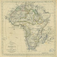
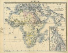 AFRIKA. - Karte. - Africa.
Farblithographie aus Adami-Kiepert bei Reimer, 1876, 24,5 x 32 cm.
Espenhorst, PP Anm. 27, S. 778. - Aus: Adami-Kiepert's "Schul-Atlas" (Ausgabe 1876). - Mit einer Nebenkarte der Nilländer. - Links im Rand eine alte hs. Notiz. (Artikelnr. 19433BG)
Erfahren Sie mehr60,00 € Inkl. MwSt. -
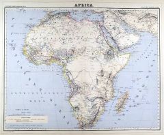
AFRIKA. - Karte. - Africa. Gesamtkarte.
Grenzkol. Kupferstich von Haubold nach Gräf und Geyer, Weimar im Geograph. Institut, 1872, 53,5 x 63,5 cm.
Espenhorst, PP 1.1.6. - Aus: Heinrich Kiepert's "Grosser Hand-Atlas" (43. Ausgabe, Auflage 1872). (Artikelnr. 32940EG)
Erfahren Sie mehr120,00 € Inkl. MwSt. -
AFRIKA. - Karte. - Africa. Gesamtkarte.
Grenzkol. Kupferstich nach Weiland, Weimar im Geograph. Institut, dat. 1841, 51 x 59,5 cm.
Espenhorst, PP 1.1.3. - Mit Farberklärungen für die Europäischen Besitzungen. (Artikelnr. 679FG)
Erfahren Sie mehr108,00 € Inkl. MwSt. -
 AFRIKA. - Karte. - Africa. Gesamtkarte.
Grenzkol. Kupferstich von Herzberg und Bembé aus Kiepert bei Reimer, Berlin, 1861, 45 x 54 cm.
Espenhorst, PP 20.1.1. - Aus: Heinrich Kiepert's "Neuer Handatlas über alle Theile der Erde" (Ausgabe 1861). - Neue Bearbeitung 1860. - Mit de... (Artikelnr. 19154BG)
Erfahren Sie mehr100,00 € Inkl. MwSt. -
AFRIKA. - Karte. - Africa. Gesamtkarte.
Grenzkol. Kupferstich von Herzberg und Bembé aus Kiepert bei Reimer, Berlin, 1858, 45 x 54 cm.
Espenhorst, PP 20.1.1. - Aus: Heinrich Kiepert's "Neuer Handatlas über alle Theile der Erde" (Ausgabe 1858). - Mit der syrischen Halbinsel (Ar... (Artikelnr. 19036BG)
Erfahren Sie mehr100,00 € Inkl. MwSt. -
AFRIKA. - Karte. - Africa. Gesamtkarte.
Grenzkol. Kupferstich von Maedel nach Weiland, Weimar im Geograph. Institut, dat. 1829, 52,5 x 61 cm.
Espenhorst, PP 1.1.2. - Mit Farberklärungen für die Europäischen Besitzungen. - Unten durchgängig wasserrandig. (Artikelnr. 33055EG)
Erfahren Sie mehr98,00 € Inkl. MwSt. -
AFRIKA. - Karte. - Africa. Gesamtkarte.
Grenzkol. Kupferstich von Biedermann und Luther aus Kiepert bei Reimer, Berlin, 1871, 45 x 54 cm.
Espenhorst, PP 20.1.2. - Aus: Heinrich Kiepert's "Neuer Handatlas über alle Theile der Erde" (Ausgabe 1871). - Neue Bearbeitung 1870. - Mit ... (Artikelnr. 19113BG)
Erfahren Sie mehr100,00 € Inkl. MwSt. -
AFRIKA. - Karte. - Africa. Gesamtkarte.
Grenzkol. Kupferstich von Biedermann und Luther aus Kiepert bei Reimer, Berlin, 1875, 45 x 54 cm.
Espenhorst, PP 20.1.2. - Aus: Heinrich Kiepert's "Neuer Handatlas über alle Theile der Erde" (Ausgabe 1875). - Neue Bearbeitung 1874. - Mit ... (Artikelnr. 19055BG)
Erfahren Sie mehr105,00 € Inkl. MwSt. -
AFRIKA. - Karte. - Africa. Große Gesamtkarte.
Grenzkol. Kupferstich von Haubold nach Gräf, Weimar im Geograph. Institut, um 1860, 53,5 x 63 cm. (Artikelnr. 18432BG)
Erfahren Sie mehr120,00 € Inkl. MwSt. -
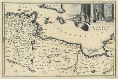
 AFRIKA. - Karte. - Africa Secundum legitimas Projectionis Steregraphicae regulas.
Altkol. Kupferstich nach J.M. Hasius bei Homann Erben, um 1750, 46 x 55,5 cm.
Tooley, Maps of Africa, S.43. - Ausgabe mit Verlagsangabe und Druckprivileg, aber ohne Datierung. Gesamtkarte mit dem Mittelmeer und Arabien. Links unten große ... (Artikelnr. 16503CG)
Erfahren Sie mehr350,00 € Inkl. MwSt. -
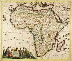 AFRIKA. - Karte. - Novissima et Perfectissima Africae descriptio.
Altkol. Kupferstich von Danckerts, um 1690, 49,5 x 57 cm.
Grenzkolorierte Gesamtkarte. Links unten prächtige figurenreiche, altkolorierte Kartusche. - Bug gering gebräunt. (Artikelnr. 10217CG)
Erfahren Sie mehr750,00 € Inkl. MwSt. -
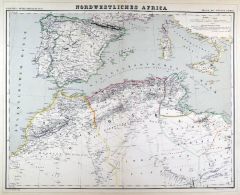
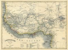
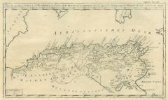
AFRIKA. - Nordwestafrika. - Karte. - Nordwestliches Africa.
Grenzkol. Kupferstich von Sulzer und Barth aus Kiepert bei Reimer, Berlin, 1875, 44 x 54,5 cm.
Espenhorst, PP 20.1.2. - Aus: Heinrich Kiepert's "Neuer Handatlas über alle Theile der Erde" (Ausgabe 1875). - Berichtigt 1875. - Die Karte zei... (Artikelnr. 19057BG)
Erfahren Sie mehr90,00 € Inkl. MwSt. -
AFRIKA. - Nordwestafrika. - Karte. - Nordwestliches Africa.
Grenzkol. Kupferstich von Sulzer und Barth aus Kiepert bei Reimer, Berlin, 1871, 44 x 54,5 cm.
Espenhorst, PP 20.1.2. - Aus: Heinrich Kiepert's "Neuer Handatlas über alle Theile der Erde" (Ausgabe 1871). - Berichtigt 1870. - Die Karte zei... (Artikelnr. 19115BG)
Erfahren Sie mehr90,00 € Inkl. MwSt. -
AFRIKA. - Nordwestafrika. - Karte. - Nordwestliches Africa.
Grenzkol. Kupferstich von Dettmers und Sulzer aus Kiepert bei Reimer, Berlin, 1858, 44 x 54,5 cm.
Espenhorst, PP 20.1.1. - Aus: Heinrich Kiepert's "Neuer Handatlas über alle Theile der Erde" (Ausgabe 1858). - Die Karte zeigt das Gebiet vo... (Artikelnr. 19038BG)
Erfahren Sie mehr90,00 € Inkl. MwSt. -
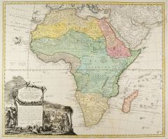
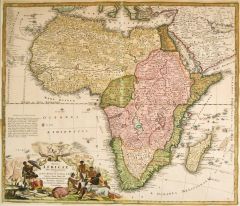 AFRIKA. - Karte. - Totius Africae nova Repraesentatio.
Altkol. Kupferstich von J.B. Homann, um 1720, 48,5 x 56,5 cm.
Vgl. Tooley, Maps of Africa, S. 43. - Ausgabe ohne Druckprivileg. Gesamtkarte mit dem Mittelmeer und Arabien. Links unten große figürliche, altkolorierte Kartusche. - Im Ganze... (Artikelnr. 27116CG)
Erfahren Sie mehr550,00 € Inkl. MwSt. -
 AFRIKA. - Nordwestafrika. - Karte. - Nordwestliches Africa.
Grenzkol. Kupferstich von Sulzer und Barth aus Kiepert bei Reimer, Berlin, 1861, 44 x 54,5 cm.
Espenhorst, PP 20.1.1. - Aus: Heinrich Kiepert's "Neuer Handatlas über alle Theile der Erde" (Ausgabe 1861). - Neue Bearbeitung 1861. - Die Kar... (Artikelnr. 19156BG)
Erfahren Sie mehr90,00 € Inkl. MwSt. -
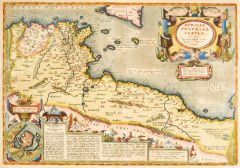 AFRIKA. - Nordostafrika. - Karte. - Africae Propriae Tabula.
Altkol. Kupferstich von Ortelius, um 1590, 33,5 x 48,5 cm.
Van den Broecke 218. - Zeigt Tunesien und Libyen sowie einen Teil von Algerien. - Mit großer figürlicher altkolorierter Kartusche rechts oben, einem Plan von Carthago links unten... (Artikelnr. 21269CG)
Erfahren Sie mehr650,00 € Inkl. MwSt. -
AFRIKA. - Nordostafrika. - Karte. - Das Nordöstiche Africa.
Grenzkol. Kupferstich von Haubold und Dietrich nach Ohmann, Weimar im Geograph. Institut, 1876, 63 x 52,5 cm.
Espenhorst, AS, 1.1.6. - Zeigt im Norden das Mittelmeer mit Griechenland und südliche Türkei bis zum Kaspischen Meer, im Osten ... (Artikelnr. 32611EG)
Erfahren Sie mehr120,00 € Inkl. MwSt. -
AFRIKA. - Nordostafrika. - Karte. - Das Nordöstiche Africa.
Grenzkol. Kupferstich von Haubold/Dietrich/Ohmann nach Gräf/Lejean, Weimar im Geograph. Institut, 1872, 64 x 52 cm.
Espenhorst, PP 1.1.6. - Aus: Heinrich Kiepert's "Grosser Hand-Atlas" (43. Ausgabe, Auflage 1872). - Gewann 1871 die einzig... (Artikelnr. 32944EG)
Erfahren Sie mehr118,00 € Inkl. MwSt. -
AFRIKA. - Nordostafrika. - Karte. - Das Nordöstiche Africa.
Grenzkol. Kupferstich von Haubold und Ohmann nach Gräf und Lejean, Weimar im Geograph. Institut, 1872, 64 x 52 cm.
Espenhorst, PP 1.1.6. - Aus: Heinrich Kiepert's "Grosser Hand-Atlas" (43. Ausgabe, Auflage 1872). - Gewann 1871 die einzige... (Artikelnr. 35474EG)
Erfahren Sie mehr120,00 € Inkl. MwSt. -
AFRIKA. - Nordwestafrika. - Karte. - Das Nordwestliche Africa.
Grenzkol. Kupferstich von Haubold/Dietrich nach Gräf, Weimar im Geograph. Institut, 1872, 64 x 52 cm.
Espenhorst, AS, 1.1.6. - Aus: Heinrich Kiepert's "Grosser Hand-Atlas" (43. Ausgabe, Auflage 1872). - Zeigt im Norden das Gebiet von Li... (Artikelnr. 32941EG)
Erfahren Sie mehr102,00 € Inkl. MwSt. -
AFRIKA. - Nordwestafrika. - Karte. - Das Nordwestliche Africa.
Grenzkol. Kupferstich von Haubold und Dietrich nach Kiepert, Weimar im Geograph. Institut, 1876, 63 x 53 cm.
Espenhorst, AS, 1.1.6. - Zeigt im Norden das Gebiet von Libyen bis Marokko, nach Süden die Länder im Inneren und die Küste bis ... (Artikelnr. 32587EG)
Erfahren Sie mehr100,00 € Inkl. MwSt. -
 AFRIKA. - Karte. - Charte von Africa gezeichnet von Friedrich Haller von Hallerstein. Gesamtkarte.
Grenzkol. Kupferstich nach Hallerstein bei Campe, Nürnberg, 1818, 25 x 25 cm.
Espenhorst, PP 52.3, aus "Neuer Handatlas". - Alt aufgezogen, leicht angestaubt, im Rand leicht fleckig, im Eck unten rechts Besitzerstempel. (Artikelnr. 32884EG)
Erfahren Sie mehr120,00 € Inkl. MwSt. -
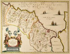 MAROKKO. - Karte. - Fezzae et Marocchi Regna Africae celeberrima. Gesamtkarte.
Altkol. Kupferstich nach Ortelius bei Blaeu, um 1650, 38 x 49,5 cm.
Die nicht genordete Karte zeigt gesamt Marokko. Dekorativ verziert mit Schiffen im Meer und einer großen, altkolorierten Rollwerkkartusche mit Figuren links unten. - Mini... (Artikelnr. 20199BG)
Erfahren Sie mehr350,00 € Inkl. MwSt. -
 AFRIKA. - Westafrika. - Karte. - Senegambien (West Africa) 1850.
Grenzkol. Stahlstich von Biedermann aus Meyer's Zeitungsatlas, 1853, 18,5 x 25 cm. (Artikelnr. 7369BG)
Erfahren Sie mehr38,00 € Inkl. MwSt. -
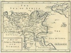 AFRIKA. - Nordafrika. - Karte. - A Map of Africa Propria and Numidia. Historische Küstenkarte zwischen Algier und Tripolis, im Nordosten Sizilien.
Kupferstich von J. Basire, um 1750, 20,5 x 27,5 cm.
Geglättete Längs- und Querfalten. (Artikelnr. 18790BG)
Erfahren Sie mehr62,00 € Inkl. MwSt. -
AFRIKA. - Karte. - Neueste Karte von Africa. Gesamtkarte, mit Südeuropa und Vorderasien bis Beludschistan.
Grenzkol. Stahlstich nach Radefeld aus Meyer bei BI, dat. 1844, 30 x 37 cm.
Espenhorst, PP 3.3. - Aus: "Meyer's Handatlas". - Im Rand etwas fleckig. (Artikelnr. 32954EG)
Erfahren Sie mehr85,00 € Inkl. MwSt. -
AFRIKA. - Nordostafrika. - Karte. - Das Nordoestliche Africa oder Aegypten, Nubien, Habesch, Kordofan und Darfur. Gebietskarte.
Grenzkol. Kupferstich nach Weiland, Weimar im Geograph. Institut, dat. 1829, 39 x 32 cm.
Espenhost, PP 1.2.2. - Aus dem verkleinerten "Hand-Atlas ... für Bürgerschulen und Zeitungsleser" (sog. Bund-Ausgabe). - Seltener ("greater rarity")... (Artikelnr. 33321EG)
Erfahren Sie mehr95,00 € Inkl. MwSt. -
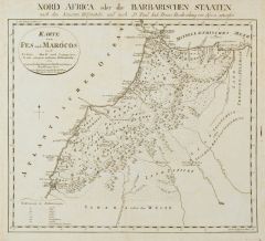 MAROKKO. - Karte. - Karte von Fes und Marócos.
Kupferstich von F.G. Canzler, Nürnberg, dat. 1797, 29,5 x 34,5 cm.
Entworfen nach "Nord Africa, oder die Barbarischen Staaten, nach den Neuesten Hilfsmitteln und nach D. Paul Iak. Bruns Beschreibung von Africa". - Auf Leinwand aufgezogen ... (Artikelnr. 2184GG)
Erfahren Sie mehr240,00 € Inkl. MwSt. -
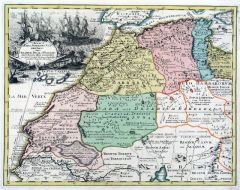
AFRIKA. - Nordwestafrika. - Karte. - Das Nordwestliche Africa. Gebietskarte, mit Nebenkarte.
Grenzkol. Kupferstich nach Weiland, Weimar im Geograph. Institut, dat. 1829, 42,5 x 65,5 cm.
Espenhost, PP 1.2.2. - Aus dem verkleinerten "Hand-Atlas ... für Bürgerschulen und Zeitungsleser" (sog. Bund-Ausgabe). - Seltener ("greater rari... (Artikelnr. 33322EG)
Erfahren Sie mehr90,00 € Inkl. MwSt. -
 ALGERIEN. - Tunesien. - Karte. - Das alte eigentliche Africa und Numidien ... oder das Reich der Massylier usw. Historische Karte, im Westen die Mündung des Muluja, im Osten die Kleine Syrte.
Kupferstich, Halle, um 1760, 20,5 x 34 cm.
Aus "Übersetzung der Allgemeinen Welthistorie". - Geglättete Längsfalten. (Artikelnr. 35844EG)
Erfahren Sie mehr92,00 € Inkl. MwSt. -
AFRIKA. - Nordostafrika. - Karte. - Das Nordoestliche Africa oder Aegypten, Nubien, Habesch, Kordofan und Dar-Fur. Gebietskarte, mit Nebenkarte.
Grenzkol. Kupferstich von Jungmann nach Weiland, Weimar im Geograph. Institut, dat. 1841, 59,5 x 48 cm.
Espenhorst, PP 1.1.3. - Zeigt Ägypten, Sudan, Nordäthiopien und das Rote Meer. Die Nebenkarte zeigt den "Grundriß von Alexandria". -... (Artikelnr. 680FG)
Erfahren Sie mehr98,00 € Inkl. MwSt. -
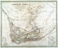
SÜDAFRIKA. - Karte. - Die Südspitze von Africa mit der Colonie am Vorgebirge der guten Hoffnung und dem Kaffern-Lande. Mit Nebenkarte.
Grenzkol. Kupferstich von Jungmann nach Weiland, Weimar im Geograph. Institut, dat. 1840, 49,5 x 64,5 cm.
Espenhorst, PP 1.1.3. - Zeigt den "Südrand von Africa und dessen Stufenlaender" ab dem 22. Breitengrad. - Die Nebenkarte zeigt "Die ... (Artikelnr. 685FG)
Erfahren Sie mehr128,00 € Inkl. MwSt. -
 AFRIKA. - Nordwestafrika. - Karte. - Das Nordwestliche Africa. Gebietskarte, mit zwei Nebenkarten.
Grenzkol. Kupferstich von Jungmann nach Weiland und Kiepert, Weimar im Geograph. Institut, dat. 1854, 43 x 65,5 cm.
Espenhorst, PP 1.1.4. - Zeigt "die Staaten Fez und Marokko, Algier, Tunis und Tripoli, die Sahara, Canarischen und Azorisch... (Artikelnr. 33176EG)
Erfahren Sie mehr120,00 € Inkl. MwSt. -
AFRIKA. - Nordwestafrika. - Karte. - Das Nordwestliche Africa. Gebietskarte, mit zwei Nebenkarten.
Grenzkol. Kupferstich von Jungmann nach Weiland, Weimar im Geograph. Institut, Weimar, dat. 1841, 42,5 x 65,5 cm.
Espenhorst, PP 1.1.3. - Zeigt "die Staaten Fez und Marokko, Algier, Tunis und Tripoli, die Sahara, Canarischen und Azorischen... (Artikelnr. 681FG)
Erfahren Sie mehr108,00 € Inkl. MwSt. -
AFRIKA. - Nordostafrika. - Karte. - Das Nordoestliche Africa oder Aegypten, Nubien, Habesch, Kordofan und Darfur. Gebietskarte, mit zwei Nebenkarten.
Grenzkol. Kupferstich von Mädel nach Weiland, Weimar im Geograph. Institut, dat. 1829, 59,5 x 48 cm.
Espenhorst, PP 1.1.2. - Zeigt Ägypten, Sudan, Nordäthiopien und das Rote Meer. Die Nebenkarten zeigt das Gebiet um Alexandria und Kairo... (Artikelnr. 33056EG)
Erfahren Sie mehr88,00 € Inkl. MwSt. -
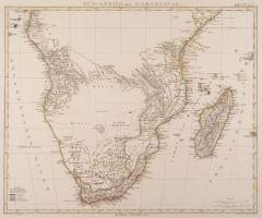
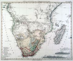
SÜDAFRIKA. - Karte. - Süd Africa mit Madagascar.
Grenzkol. Kupferstich von Haubold nach Gräf/Ohmann, Weimar im Geograph. Institut, 1872, 51 x 64 cm.
Espenhorst, PP 1.1.6. - Aus: Heinrich Kiepert's "Grosser Hand-Atlas" (43. Ausgabe, Auflage 1872). - Gewann 1871 die einzige Goldmedaille a... (Artikelnr. 32949EG)
Erfahren Sie mehr98,00 € Inkl. MwSt. -
SÜDAFRIKA. - Karte. - Süd Africa mit Madagascar.
Grenzkol. Kupferstich von Haubold nach Gräf/Ohmann, Weimar im Geograph. Institut, 1872, 50,5 x 64 cm.
Espenhorst, PP 1.1.6. - Aus: Heinrich Kiepert's "Grosser Hand-Atlas" (43. Ausgabe, Auflage 1872). - Gewann 1871 die einzige Goldmedaille... (Artikelnr. 35266EG)
Erfahren Sie mehr90,00 € Inkl. MwSt. -
 SÜDAFRIKA. - Karte. - Süd-Africa mit Madagascar.
Grenzkol. Kupferstich nach Berghaus aus Stieler bei Perthes, Gotha, dat. 1864, 32 x 39 cm.
Aus: A. Stieler's "Hand-Atlas". - Mit Einzeichnung der Reiserouten europäischer Forscher und zwei Höhenprofilen. (Artikelnr. 18038CG)
Erfahren Sie mehr85,00 € Inkl. MwSt. -
AFRIKA. - Ostafrika. - Karte. - Oestliches Hoch-Africa mit Madagascar und dem Aethiopischen Archipel.
Grenzkol. Kupferstich nach Weiland, Weimar im Geograph. Institut, dat. 1841, 60 x 51,5 cm.
Espenhorst, PP 1.1.3. - Zeigt "Die Küstenländer Sofala, Mozambique, Zanguebar und Ajan. Das Land der Somali, das südliche Habesh, Monomotapa etc.... (Artikelnr. 684FG)
Erfahren Sie mehr98,00 € Inkl. MwSt. -
AFRIKA. - Westafrika. - Karte. - Mittel- und Nord-Africa und Arabien. Westliches Blatt. Gebietskarte.
Grenzkol. Kupferstich von Edler nach Stülpnagel aus Stieler bei Perthes, Gotha, dat. 1835, 31,5 x 36,5 cm.
Espenhorst, PP 2.1.1.1. - Aus: A. Stieler's "Hand-Atlas" (First Edition, "the one least often found" (=die seltenste Ausgabe)). - Z... (Artikelnr. 33202EG)
Erfahren Sie mehr75,00 € Inkl. MwSt. -
AFRIKA. - Nordwestafrika. - Karte. - Das Nordwestliche Africa oder die Staaten Fez und Marokko, Algier, Tunis und Tripoli, nebst der Wüste Sahara. Gebietskarte mit Kanarischen Inseln, mit Nebenkarte "Die Azoren".
Grenzkol. Kupferstich nach Weiland, Weimar im Geograph. Institut, dat. 1829, 42,5 x 66,5 cm.
Espenhorst, PP 1.1.2. - Unten im Wüstengebiet ein Wasserrand. (Artikelnr. 33057EG)
Erfahren Sie mehr108,00 € Inkl. MwSt. -
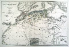
 AFRIKA. - Nordwestafrika. - Karte. - Africae Pars Superior Occidentalis in qua Theatrum Belli ab Hispanis.
Altkol. Kupferstich nach Guillaume Delisle bei Chr. Weigel, 1718, 31,5 x 41 cm.
Aus: Johann David Köhlers "Bequemer Schul= und Reisen=Atlas", 1718. - Zeigt das Gebiet von Tunesien bis zur Sahara, im Mittelmeer mit den Balearen, Sizilien u... (Artikelnr. 18669BG)
Erfahren Sie mehr280,00 € Inkl. MwSt. -
 SÜDAFRIKA. - Karte. - Die Südspitze von Africa mit der Colonie vom Vorgebirge der guten Hoffnung.
Grenzkol. Kupferstich von Kratz nach Weiland, Weimar im Geograph. Institut, dat. 1829, 32 x 39,5 cm.
Espenhost, PP 1.2.2. - Aus dem verkleinerten "Hand-Atlas ... für Bürgerschulen und Zeitungsleser" (sog. Bund-Ausgabe). - Seltener ("grea... (Artikelnr. 33326EG)
Erfahren Sie mehr100,00 € Inkl. MwSt. -
 LIBYEN. - Karte. - Africa propria. Gesamtkarte zur Zeit des Kaisers Augustus.
Kupferstich von J.G. Beck, 1773, 20,5 x 30,5 cm.
Aus: Christoph Cellarius, "Notitia orbis antiquii sive geographia plenior". - Mit figürlicher Kartusche. (Artikelnr. 19325CG)
Erfahren Sie mehr76,00 € Inkl. MwSt. -
AFRIKA. - Südwestküste. - Karte. - Nieder-Guinea und das Innere des Westlichen Mittel-Africa. Gebietskarte, mit Nebenkarte der Insel St. Helena.
Grenzkol. Kupferstich nach Weiland/Kiepert, Weimar im Geograph. Institut, dat. 1857, 61,5 x 49 cm.
Espenhorst, PP 1.1.5. - "Berichtigt 1846". Zeigt die westafrikanischen Küstenländer von Kap Lopez (Gabun) über Walfischbay bis Spencer's ... (Artikelnr. 33178EG)
Erfahren Sie mehr118,00 € Inkl. MwSt. -
AFRIKA. - Westküste. - Karte. - Westliches Mittel-Africa Senegambien, Sudan, Ober-Guinea und einen Teil der Sahara. Gebietskarte, mit drei Nebenkarten.
Grenzkol. Kupferstich von Maedel und Bernhardt nach Weiland und Kiepert, Weimar im Geograph. Institut, dat. 1857, 50,5 x 66 cm.
Espenhorst, PP 1.1.5. - "Berichtigt 1849". Zeigt die Küstenländer von Kap Blanco (Mauretanien) bis Kap Lopez ... (Artikelnr. 33177EG)
Erfahren Sie mehr120,00 € Inkl. MwSt. -
AFRIKA. - Westküste. - Karte. - Westliches Mittel-Africa Senegambien, Sudan, Ober-Guinea und einen Teil der Sahara. Gebietskarte, mit drei Nebenkarten.
Grenzkol. Kupferstich von Maedel nach Weiland, Weimar im Geograph. Institut, dat. 1840, 50 x 65 cm.
Espenhorst, PP 1.1.3. - Zeigt "Die Stufenländer des mittlern Africa's und Nordrand von Hochafrica", von Kap Blanco (Mauretanien) bis Kap L... (Artikelnr. 682FG)
Erfahren Sie mehr108,00 € Inkl. MwSt.