Suchergebnisse für: "europa karte"
-
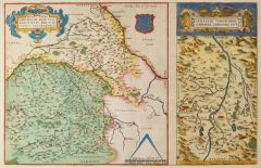
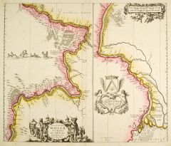
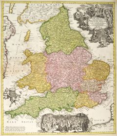 GROSSBRITANNIEN. - England. - Karte. - Magnae Britanniae pars Meridionalis in qua Regnum Anglae.
Altkol. Kupferstich von J.B. Homann, um 1730, 57 x 48,5 cm.
Die flächenkolorierte Karte zeigt England mit der Küste von Irland. Rechts oben große figürliche Kartusche mit Wappenschild und Krone, unten Parlamentsszene mit Georg I. und e... (Artikelnr. 10080CG)
Erfahren Sie mehr280,00 € Inkl. MwSt. -
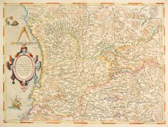
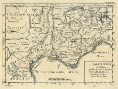 FRANKREICH. - Südfrankreich. - Karte. - Vorstellung des Weges den Hanibal genommen durch Gallien und über die Alpen bis in Italien. Historische Karte von den Pyrenäen bis Genua, im Norden der Genfer See.
Kupferstich, i.d. Platte sign. "J.F. Glasser. sch.", Halle, um 1760, 20 x 27,5 cm.
Aus "Übersetzung der Allgemeinen Welthistorie". - Geglättete Längsfalten. (Artikelnr. 35842EG)
Erfahren Sie mehr120,00 € Inkl. MwSt. -
HAUTE-VIENNE. - Karte. - Département de la Hte. Vienne, ci-devant Partie du Limosin et de la Marche.
Altkol. Aquatinta, um 1795, 16,5 x 21,5 cm.
Aus der Reihe: "Voyage dans les Departements de la France" von Joseph La Vallée, Marquis de Bois-Robert (1747 - 1816), Paris, 1793-1800. - Die Karte zeigt die Umgebung von Limoges. (Artikelnr. 16812BG)
Erfahren Sie mehr48,00 € Inkl. MwSt. -
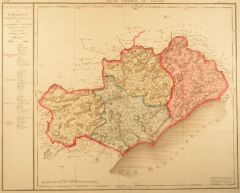 HÉRAULT. - Karte. - Département de l' Herault divisé en 4 Districts.
Altkol. Kupferstich bei B. Delaval, 1793, 50 x 55 cm.
Aus dem "Atlas National de France" der die 1790 neu geschaffenen 83 Departements darstellt. Die flächenkolorierte Karte zeigt die Umgebungen von St. Pons de Thomiere, von Beziers, von... (Artikelnr. 19488AG)
Erfahren Sie mehr190,00 € Inkl. MwSt. -
LOIRE. - Karte. - Département de la Loire Ci devant le Forez.
Altkol. Aquatinta, um 1795, 16,5 x 21,5 cm.
Aus der Reihe: "Voyage dans les Departements de la France" von Joseph La Vallée, Marquis de Bois-Robert (1747 - 1816), Paris, 1793-1800. - Die Karte zeigt die Umgebung von Roanne, Montbrison und... (Artikelnr. 16787BG)
Erfahren Sie mehr48,00 € Inkl. MwSt. -
LOIRE-ATLANTIQUE. - Karte. - Département de la Loire inférieure, ci-devant partie de la Bretagne.
Altkol. Aquatinta, um 1795, 16,5 x 21,5 cm.
Aus der Reihe: "Voyage dans les Departements de la France" von Joseph La Vallée, Marquis de Bois-Robert (1747 - 1816), Paris, 1793-1800. - Die Karte zeigt das Gebiet um Nantes. (Artikelnr. 16788BG)
Erfahren Sie mehr48,00 € Inkl. MwSt. -
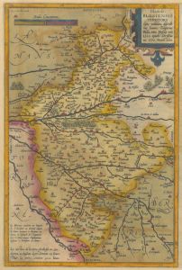
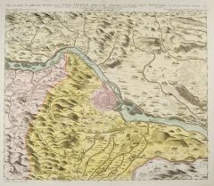
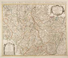 LOTHRINGEN. - Karte. - Civitas Leucorum sive Pagus Tullensis.
Grenzkol. Kupferstich von Guillaume del'Isle bei Covens & Mortier, Amsterdam, um 1730, 46 x 58 cm.
Die detaillierte Karte zeigt das Gebiet von Verdun und Metz im Norden bis Remiremont im Süden und von Saint Dizier im Westen bis Kayserberg... (Artikelnr. 972GG)
Erfahren Sie mehr340,00 € Inkl. MwSt. -
LOUDUN. - Karte. - Lovdonois. Lavdvnvm und "Mirebalais".
Altkol. Kupferstich von W.J. & J. Blaeu, um 1630, 38 x 50 cm.
Grenzkolorierte Karte (38 x 34 cm) des Gebietes um Loudun mit altkolorierter figürlicher Kartusche links unten. Rechts nicht genordete Nebenkarte (38 x 15 cm) "Mirebalais" des ... (Artikelnr. 12345BG)
Erfahren Sie mehr130,00 € Inkl. MwSt. -
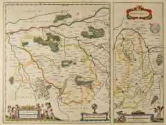 LOUDUN. - Karte. - Lovdonois. Lavdvnvm und "Mirebalais".
Altkol. Kupferstich von W.J. & J. Blaeu, um 1630, 38 x 50 cm.
Grenzkolorierte Karte (38 x 34 cm) des Gebietes um Loudun mit altkolorierter figürlicher Kartusche links unten. Rechts nicht genordete Nebenkarte (38 x 15 cm) "Mirebalais" des ... (Artikelnr. 24694CG)
Erfahren Sie mehr150,00 € Inkl. MwSt. -
MAINE-ET-LOIRE. - Karte. - Département de Mayenne et Loire, Ci-devant Partie de l'Anjou et du Saumurois.
Altkol. Aquatinta, um 1795, 16,5 x 21,5 cm.
Aus der Reihe: "Voyage dans les Departements de la France" von Joseph La Vallée, Marquis de Bois-Robert (1747 - 1816), Paris, 1793-1800. - Die Karte zeigt das Gebiet um Angers. (Artikelnr. 16793BG)
Erfahren Sie mehr48,00 € Inkl. MwSt. -
MANCHE. - Karte. - Département de la Manche, ci-devant partie de la Normandie.
Altkol. Aquatinta, um 1795, 21,5 x 16,5 cm.
Aus der Reihe: "Voyage dans les Departements de la France" von Joseph La Vallée, Marquis de Bois-Robert (1747 - 1816), Paris, 1793-1800. - Die Karte zeigt die Umgebung von Valognes, Carentan, Co... (Artikelnr. 16790BG)
Erfahren Sie mehr48,00 € Inkl. MwSt. -
MAYENNE. - Karte. - Département de la Mayenne, ci-devant partie du Maine et de l'Anjou.
Altkol. Aquatinta, um 1795, 16,5 x 21,5 cm.
Aus der Reihe: "Voyage dans les Departements de la France" von Joseph La Vallée, Marquis de Bois-Robert (1747 - 1816), Paris, 1793-1800. - Die Karte zeigt die Umgebung von Laval und Mayenne. (Artikelnr. 16792BG)
Erfahren Sie mehr48,00 € Inkl. MwSt. -
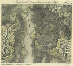
 MONTCHANIN. - Karte. - Les environs de L'Estange de Longpendu, Comprenant une grande partie du Comtè de Charolois.
Altkol. Kupferstich von Blaeu, um 1630, 38 x 50 cm.
Grenzkolorierte Karte der Umgebung von Montchanin zwischen Couches im Westen und Mont-St. Vincent im Osten mit altkolorierter figürlicher Kartusche und Wappen. Breitrandig und tadellos. (Artikelnr. 12348BG)
Erfahren Sie mehr142,00 € Inkl. MwSt. -
OISE. - Karte. - Département de l'Oise, ci-devant partie de l'Ile de France et de la Picardie.
Altkol. Aquatinta, um 1795, 16,5 x 21,5 cm.
Aus der Reihe: "Voyage dans les Departements de la France" von Joseph La Vallée, Marquis de Bois-Robert (1747 - 1816), Paris, 1793-1800. - Die Karte zeigt das Gebiet um Beauvais. (Artikelnr. 16796BG)
Erfahren Sie mehr48,00 € Inkl. MwSt. -
ORNE. - Karte. - Département de l'Orne, ci-devant partie de la Normandie et du Perche.
Altkol. Aquatinta, um 1795, 16,5 x 21,5 cm.
Aus der Reihe: "Voyage dans les Departements de la France" von Joseph La Vallée, Marquis de Bois-Robert (1747 - 1816), Paris, 1793-1800. - Die Karte zeigt die Umgebung von Argentan und Alencon. (Artikelnr. 16797BG)
Erfahren Sie mehr48,00 € Inkl. MwSt. -
SARTHE. - Karte. - Département de la Sarte, ci-devant partie du Maine et de l'Anjou.
Altkol. Aquatinta, um 1795, 16,5 x 21,5 cm.
Aus der Reihe: "Voyage dans les Departements de la France" von Joseph La Vallée, Marquis de Bois-Robert (1747 - 1816), Paris, 1793-1800. - Die Karte zeigt die Umgebung von Le Mans. (Artikelnr. 16806BG)
Erfahren Sie mehr48,00 € Inkl. MwSt. -
BALKAN. - Karte. - Die Balkanhalbinsel. Die Balkanhalbinsel (ohne Griechenland) in 4 Blättern.
4 Farblithographien aus Sohr-Berghaus bei Flemming, Glogau, um 1885, je 32 x 37,5 cm.
Espenhorst, PP 4.1.3. - Aus: Sohr-Berghaus's "Hand-Atlas über alle Teile der Erde". - Die 4-teilige Karte mit 5 Nebenkarten von Kreta, Grundrissplan von... (Artikelnr. 19501BG)
Erfahren Sie mehr320,00 € Inkl. MwSt. -
ALLIER. - Karte. - Département de l'Allier, ci-devant Partie de Bourbonnois et de l'Auvergne.
Altkol. Aquatinta, um 1795, 16,5 x 21,5 cm.
Aus der Reihe: "Voyage dans les Departements de la France" von von Joseph La Vallée, Marquis de Bois-Robert (1747 - 1816), Paris, 1793-1800. - Die Karte zeigt das Gebiet um Moulins und Montlucon... (Artikelnr. 16750BG)
Erfahren Sie mehr48,00 € Inkl. MwSt. -
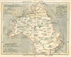 AVEYRON. - Karte. - Département de l'Avéiron, ci-devant le Rouergue, partie de la Guienne.
Altkol. Aquatinta, um 1795, 16,5 x 21,5 cm.
Aus der Reihe: "Voyage dans les Departements de la France" von Joseph La Vallée, Marquis de Bois-Robert (1747 - 1816), Paris, 1793-1800. - Die Karte zeigt das Gebiet um Rodez. (Artikelnr. 16759BG)
Erfahren Sie mehr48,00 € Inkl. MwSt. -
 BERRY. - Karte. - Regionis, Bitvrigvm exactiss: descriptio (31 x 31 cm) und "Limaniae Topographia".
Altkol. Kupferstich von Ortelius nach Chaumeau, um 1580, 31 x 48,5 cm.
Flächenkolorierte Karte des gesamten Gebiets mit altkolorierter Rollwerkkartusche und Wappen. Rechts Nebenkarte (31 x 15,5 cm) "Limaniae Topographia Gabriele Symeoneo ... (Artikelnr. 24693CG)
Erfahren Sie mehr140,00 € Inkl. MwSt. -
BESANCON. - Karte. - Département du Doubs ... en 6. Districts.
Kupferstich bei J. B. Delaval, 1793, 50 x 49,5 cm.
Aus dem "Atlas National de France" der die 1790 neu geschaffenen 83 Departements darstellt. Die flächenkolorierte Karte zeigt die Umgebung von Besancon, Baume-les-Dames, S. Hypolite, Pont... (Artikelnr. 15684BG)
Erfahren Sie mehr95,00 € Inkl. MwSt. -
 BLOIS. - Karte. - Blaisois, Blesiensis Territorii.
Altkol. Kupferstich bei A. Ortelius, 1602, 33,5 x 22 cm.
Van den Broecke 43a. - Aus der spanischen Ausgabe von 1602. Verso Text zu Blois und dem Limousin sowie zwei altkolorierte Initialen. - Die Karte zeigt das Gebiet um Blois von Amboise... (Artikelnr. 27876CG)
Erfahren Sie mehr120,00 € Inkl. MwSt. -
 BREST. - Karte. - Département du Finisterre ... en 9 Districts.
Altkol. Kupferstich bei J. B. Delaval, 1793, 50 x 49,5 cm.
Aus dem "Atlas National de France" der die 1790 neu geschaffenen 83 Departements darstellt. Die flächenkolorierte Karte zeigt die Umgebung von Brest, Lesneven, Morlaix, Carhaix, Q... (Artikelnr. 15685BG)
Erfahren Sie mehr152,00 € Inkl. MwSt. -
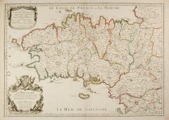 BRETAGNE. - Karte. - La Bretagne diviseé en ses neuf Eveschés qui font aussi l'estendue des recepts de la Genralité de Nantes.
Altkol. Kupferstich von Cordier bei Jaillot, dat. 1706, 46 x 65 cm.
Die grenzkolorierte Karte zeigt die neun Bistümer der Bretagne. - Vor allem im Rand etwas fleckig und gebräunt. (Artikelnr. 1765GG)
Erfahren Sie mehr400,00 € Inkl. MwSt. -
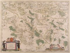
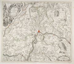
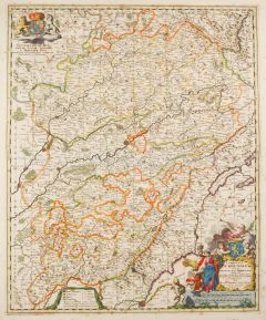 BURGUND. - Karte. - Comitatus Burgundiae tam in praecipuas ejus praefecturas.
Altkol. Kupferstich von Nicolas Visscher, um 1695, 57 x 47 cm.
Die grenzkolorierte Karte zeigt das Gebiet zwischen Remiremont (Norden), Genf (Süden), Auxonne (Westen) und dem Bielersee (Osten) . Rechts unten altkolorierte figürliche Kart... (Artikelnr. 966GG)
Erfahren Sie mehr380,00 € Inkl. MwSt. -
CHARENTE. - Karte. - Département de la Charente, ci-devant Angoumois, partie de la Saintonge et du Poitou.
Altkol. Aquatinta, um 1795, 16,5 x 21,5 cm.
Aus der Reihe: "Voyage dans les Departements de la France" von Joseph La Vallée, Marquis de Bois-Robert (1747 - 1816), Paris, 1793-1800. - Die Karte zeigt das Gebiet um Angouleme. (Artikelnr. 16776BG)
Erfahren Sie mehr48,00 € Inkl. MwSt. -
CÔTES-D'ARMOR. - Karte. - Département des Côtes du Nord, ci-devant partie de la Bretagne.
Altkol. Aquatinta, um 1795, 16,5 x 21,5 cm.
Aus der Reihe: "Voyage dans les Departements de la France" von Joseph La Vallée, Marquis de Bois-Robert (1747 - 1816), Paris, 1793-1800. - Die Karte zeigt das Gebiet zwischen Lannion und Dinan. (Artikelnr. 16795BG)
Erfahren Sie mehr48,00 € Inkl. MwSt. -
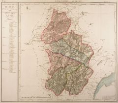 DOLE/an der Doubs. - Karte. - Département du Jura ... en 6. Districts.
Altkol. Kupferstich bei J. B. Delaval, 1793, 49,5 x 48,5 cm.
Aus dem "Atlas National de France" der die 1790 neu geschaffenen 83 Departements darstellt. Die flächenkolorierte Karte zeigt die Umgebung von Dole, Arbois, Poligny, St. Claude,... (Artikelnr. 15683BG)
Erfahren Sie mehr95,00 € Inkl. MwSt. -
EURE. - Karte. - Département de l'Eure, ci-devant Partie de la Normandie.
Altkol. Aquatinta, um 1795, 16,5 x 21,5 cm.
Aus der Reihe: "Voyage dans les Departements de la France" von Joseph La Vallée, Marquis de Bois-Robert (1747 - 1816), Paris, 1793-1800. - Die Karte zeigt das Gebiet um Évreux. - Rechts kleiner... (Artikelnr. 16781BG)
Erfahren Sie mehr48,00 € Inkl. MwSt. -
 RUSSLAND. - Karte. - Carte Nouvelle de Moscovie Represente la partie Septentrionale.
Altkol. Kupferstich bei J.B. Elwe, dat. 1792, 41 x 55 cm.
Koeman, Atlantes Neerlandici, Bd. II, S. 105 f. El 2. - Die flächenkolorierte Karte zeigt das Gebiet nördlich von Moskau mit dem Ladoga-See, Onega-See, die Halbinsel Kola und dem ... (Artikelnr. 18020BG)
Erfahren Sie mehr480,00 € Inkl. MwSt. -
 RUSSLAND. - Karte. - Tavrica Chersonesvs, Notra aetate Przecopsca, et Gazara dicitur.
Altkol. Kupferstich von Blaeu, um 1640, 38 x 50 cm.
Die grenzkolorierte Karte zeigt die nördliche Umgebung des Asowschen Meeres bis Nowgorod, Moskau, und bis zum Donez im Osten sowie im Süden die Insel Krim. Mit altkolorierter Kartusche ... (Artikelnr. 17998BG)
Erfahren Sie mehr280,00 € Inkl. MwSt. -
 WOLGA. - Karte. - Nova et Accurata Wolgae Fluminis.
Grenzkol. Kupferstich nach J. Janssonius & J. Waesberge bei Moses Pitt, um 1650, 47 x 55 cm.
Die altkolorierte Karte zeigt in zwei Segmenten nebeneinander den Lauf der Wolga von Nischni Nowgorod bis zur Mündung ins Schwarze Meer bei Astra... (Artikelnr. 25361CG)
Erfahren Sie mehr500,00 € Inkl. MwSt. -
 WIEN. - Karte. - Chorographia VI. milliarium Regionis circa Urbem Viennam Austriacam, deprompta ex inappa majori Vischeriana.
Altkol. Kupferstich nach Nicolas Visscher bei Homann Erben, dat. 1748, 46 x 55,5 cm.
Die flächenkolorierte Karte zeigt den Lauf der Donau von Klein Schöhnbühel bis Petronell, mittig ein Grundrissplan von Wien. - Die Ränder teils mit L?... (Artikelnr. 1766GG)
Erfahren Sie mehr400,00 € Inkl. MwSt. -
OBERÖSTERREICH. - Karte. - Austria Superior secundum IIII. Quadrantes & regiones contiguas.
Altkol. Kupferstich von Mich. Kauffer bei Chr. Weigel, 1718, 27,5 x 34 cm.
Aus: Johann David Köhlers "Bequemer Schul= und Reisen=Atlas", 1718. - Die Karte zeigt das gesamte Oberösterreich, eingeteilt in seine vier Viertel (Mühl-, Schwar... (Artikelnr. 4834CG)
Erfahren Sie mehr140,00 € Inkl. MwSt. -
 SCHAFFHAUSEN. - Karte. - Ditionis pagi Scaphusiani qui confoederatae Helvetiorum.
Altkol. Kupferstich von Tobias Lotter, um 1730, 49 x 57 cm.
Die grenzkolorierte Karte zeigt das Gebiet von Kaiserstuhl im Westen bis Stein im Osten, mit Schaffhausen in der Mitte. Kartusche mit figürlicher Darstellung, Wappen von Schaffha... (Artikelnr. 1362GG)
Erfahren Sie mehr750,00 € Inkl. MwSt. -
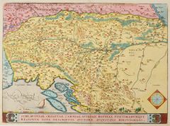 SLOWENIEN. - Karte. - Schlavoniae, Croatiae, Carniae, Istriae, Bosniae, Finitimarumque Regionum nova descriptio.
Kol. Kupferstich von Abraham Ortelius nach Augustin Hirschvogel, 1579, 33 x 45,5 cm.
Van den Broecke Nr. 145. - Die flächenkolorierte Karte zeigt das Gebiet südlich der Drau bis zum Golf von Triest, Istrien, im Osten zur Donau. Mit kolor... (Artikelnr. 20195BG)
Erfahren Sie mehr380,00 € Inkl. MwSt. -
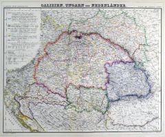
UNGARN. - Karte. - Galizien, Ungarn und Nebenländern.
Grenzkol. Kupferstich von Dekinder und Eyb aus Kiepert bei Reimer, Berlin, 1858, 45 x 54 cm.
Espenhorst, PP 20.1.1. - Aus: Heinrich Kiepert's "Neuer Handatlas über alle Theile der Erde" (Ausgabe 1858). - Die Karte zeigt das Königreich Un... (Artikelnr. 19025BG)
Erfahren Sie mehr90,00 € Inkl. MwSt. -
 UNGARN. - Karte. - Galizien, Ungarn und Nebenländern.
Grenzkol. Kupferstich von Dekinder und Eyb aus Kiepert bei Reimer, Berlin, 1861, 45 x 54 cm.
Espenhorst, PP 20.1.1. - Aus: Heinrich Kiepert's "Neuer Handatlas über alle Theile der Erde" (Ausgabe 1861). - Die Karte zeigt das Königreich Un... (Artikelnr. 19134BG)
Erfahren Sie mehr90,00 € Inkl. MwSt. -
 MAILAND. - Karte. - Ducatus Mediolanensis
Altkol. Kupferstich von A. Ortelius nach G.G. Settala, um 1575, 36 x 48 cm.
Nach Westen orientierte Karte des Herzogtums Mailand. Im Westen bis Nizza und Fribourg, im Osten bis Pisa, im Süden bis zum Mittelmeer und im Norden bis Luzern re... (Artikelnr. 27251CG)
Erfahren Sie mehr550,00 € Inkl. MwSt. -
 NEAPEL. - Karte. - Regni Neapolitani Verissima Secundum Antiquorum et Recentiorum Traditionem Descriptio, Pyrrho Ligorio Auct.
Altkol. Kupferstich von Ortelius, 1584, 36,5 x 50 cm.
Van den Broecke, Ortelius Atlas Maps Nr. 139. - Nicht genordete Karte Süditalien von Terracina bis Messina. Geschmückt mit einer Galeone und einer Kompassrose, unten mittig die Titelk... (Artikelnr. 24673CG)
Erfahren Sie mehr450,00 € Inkl. MwSt. -
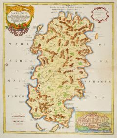 SARDINIEN. - Karte. - Sardiniae Regnum et Insula.
Altkol. Kupferstich nach P. Vincenzo Coronelli bei Homann Erben, dat. 1734, 58,5 x 49 cm.
Detaillierte Karte die auch die Inseln Tavolara, Sant Antioco, Sant Pietro, Asinara und die Meerenge von Bocche die Bonifacio zeigt. Mit altkoloriert... (Artikelnr. 23504CG)
Erfahren Sie mehr550,00 € Inkl. MwSt. -
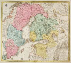 SCHWEDEN. - Karte. - Nova Mappa Geographica Sueciae ac Gothiae Regna ut et Finlandiae Ducatum ac Lappponiam.
Altkol. Kupferstich von Tobias Conrad Lotter, um 1760, 49 x 57 cm.
Die flächenkolorierte Karte zeigt Schweden, Finnland und Estland, mit Bottnischen und Finnischen Meerbusen und bis zum weißen Meer. Mit figürlicher Kartusche unten recht... (Artikelnr. 2121GG)
Erfahren Sie mehr300,00 € Inkl. MwSt. -
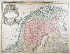 SKANDINAVIEN. - Karte. - Carte des Courones du Nord qui Comprend les Royaumes de Danemark, Suede, & Norwege.
Altkol. Kupferstich von Covens & Mortier, um 1680, 54,5 x 60,5 cm.
Die flächenkolorierte Karte zeigt das nördliche Gebiet von Skandinavien. Mit großer Kartusche und Wappen links oben und Kopftitel. - Die Ränder links und rechts etwas f... (Artikelnr. 18029BG)
Erfahren Sie mehr380,00 € Inkl. MwSt. -
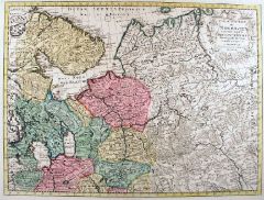
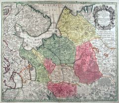
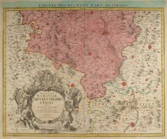 OLMÜTZ. - Karte. - Marchionatus Moraviae Circulus Olomucensis quem Mandato Caesareo accuratè emensus.
Altkol. Kupferstich nach J.Chr. Müller bei J.B. Homann, um 1720, 46,5 x 57 cm.
Die flächenkolorierte Karte zeigt das Gebiet um Olmütz und zwischen Littau (Norden), Trschitz, Morkowitz (Süden) und Boskowitz. Links unten große figürlic... (Artikelnr. 18430BG)
Erfahren Sie mehr180,00 € Inkl. MwSt. -
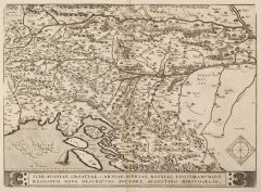
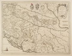 BALKAN. - Karte. - Sclavonia, Croatia, Bosnia cum Dalmatiae parte. Karte des westlichen Balkan.
Kupferstich von Gerhard Mercator, um 1600, 36 x 46 cm.
Karte der heutigen Staaten Slowenien, Kroatien, Bosnien-Herzegowina und Serbien. Sie reicht im Norden bis zur Drau, im Süden bis zum Unterlauf der Drina, im Westen bis Ptuj und im Ost... (Artikelnr. 2406GG)
Erfahren Sie mehr320,00 € Inkl. MwSt. -
 SLOWENIEN. - Karte. - Schlavoniae, Croatiae, Carniae, Istriae, Bosniae, Finitimarumque Regionum nova descriptio.
Kupferstich von Abraham Ortelius nach Augustin Hirschvogel, 1579, 33 x 45,5 cm.
Van den Broecke Nr. 145. - Die Karte zeigt das Gebiet südlich der Drau bis zum Golf von Triest, Istrien, im Osten zur Donau. Mit Rollwerkkartusche. - Im Bugbe... (Artikelnr. 2407GG)
Erfahren Sie mehr330,00 € Inkl. MwSt. -
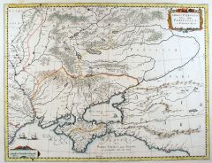
 RUSSLAND. - Karte. - Mappae Imperii Moscovitici pars Septentrionalis / pars Australis.
2 altkol. Kupferstiche von M. Seutter, um 1740, je ca. 49,5 x 57 cm.
Die zweiteilige, flächenkolorierte Karte zeigt das Gebiet nördlich und südlich von Moskau mit dem Ladoga-See, Onega-See, die Halbinsel Kola und dem Weißen Meer im Nor... (Artikelnr. 18035BG)
Erfahren Sie mehr580,00 € Inkl. MwSt. -
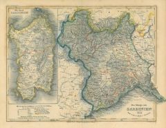 SARDINIEN. - Karte. - Das Königreich Sardinien 1856 mit Nebenkarte der Insel.
Grenzkol. Stahlstich nach Radefeld aus Meyer's Zeitungsatlas, 1856, 20 x 26 cm.
Karte des Piemont und der Insel Sardinien. (Artikelnr. 507AG)
Erfahren Sie mehr48,00 € Inkl. MwSt. -
TÜRKEI. - Karte. - Europäische und Asiatische Türkey nach den neuesten geographischen Ortsbestimmungen, und den besten Hilfsmitteln verfasst. Das gesamte Osmanische Reich, von Bosnien, Walachei und Moldau im Nordwesten bis zur persisch
Grenzkol. Kupferstich bei T. Mollo, Wien, um 1825, 32,5 x 45,5 cm.
Zeigt namentlich aufgeführt die zwölf "Länder und Provinzen in Europa" und die vier "in Asien", im Norden das Schwarze Meer und Südrußland mit Kaukasus, im Südosten d... (Artikelnr. 603FG)
Erfahren Sie mehr120,00 € Inkl. MwSt.