Suchergebnisse für: "europa karte"
-
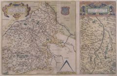
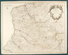
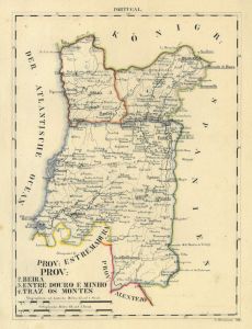 BEIRA. - Karte. - Prov: Beira, Entre Douro e Minho und Traz os Montes.
Grenzkol. Lithographie bei Schlieben, 1829, 26 x 19 cm.
Karte des nördlichen Portugal mit Braga, Porto, Braganca und Coimbra. (Artikelnr. 18130CG)
Erfahren Sie mehr86,00 € Inkl. MwSt. -
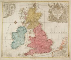 GROSSBRITANNIEN. - Karte. - La Grande Bretagne ou les Royaumes D'Angleterre et D'Ecosse comme aussi le Royaume D'Irlande.
Altkol. Kupferstich von Matthäus Albrecht Lotter bei Tobias Conrad Lotter, um 1760, 49 x 58 cm.
Die flächenkolorierte Karte zeigt Großbritannien mit Irland. Mit figürlicher Kartusche oben rechts, in der linken Ecke die Wappen von Engla... (Artikelnr. 2122GG)
Erfahren Sie mehr300,00 € Inkl. MwSt. -
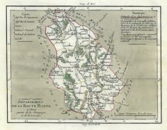 HAUTE-MARNE. - Karte. - Département de la Haute Marne, ci-devant partie de la Champagne et de la Lorraine.
Altkol. Aquatinta, um 1795, 16,5 x 21,5 cm.
Aus der Reihe: "Voyage dans les Departements de la France" von Joseph La Vallée, Marquis de Bois-Robert (1747 - 1816), Paris, 1793-1800. - Die Karte zeigt die Umgebung von Chaumont. (Artikelnr. 16791BG)
Erfahren Sie mehr48,00 € Inkl. MwSt. -
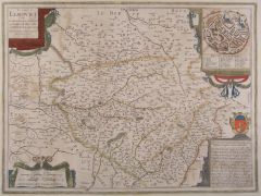
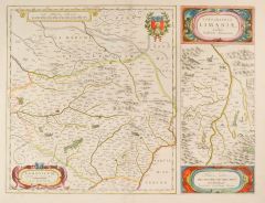 LIMOGES. - Karte. - Lemovicvm und "Topographia Limaniae".
Altkol. Kupferstich von W.J. Blaeu nach Faiano, um 1630, 38 x 50 cm.
Grenzkolorierte Karte (38 x 34 cm) des Gebietes um Limoges mit Rollwerkkartusche links unten und Wappen rechts oben (beides altkoloriert). Rechts Nebenkarte (38 x 15 cm) ... (Artikelnr. 12322BG)
Erfahren Sie mehr180,00 € Inkl. MwSt. -
 LIMOGES. - Karte. - Totius Lemovici et Confinium provinciarum quantum ad diaecesin Lemovicensen spectant.
Altkol. Kupferstich von Janssonius nach Faiano, um 1682, 38 x 50 cm.
Grenzkolorierte, nicht genordete Karte des Gebiets um Limoges mit Planansicht der Stadt (9 x 9,5 cm) sowie Legende (A-Z), Rollwerkkartusche links oben und Wappen mit Erkl... (Artikelnr. 12542BG)
Erfahren Sie mehr133,00 € Inkl. MwSt. -
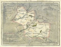 LOIR-ET-CHER. - Karte. - Département du Loir et du Cher, ci-devant partie de l'Orléanois de la Beauce et du Berri.
Altkol. Aquatinta, um 1795, 21,5 x 16,5 cm.
Aus der Reihe: "Voyage dans les Departements de la France" von Joseph La Vallée, Marquis de Bois-Robert (1747 - 1816), Paris, 1793-1800. - Die Karte zeigt das Gebiet um Blois. (Artikelnr. 16777BG)
Erfahren Sie mehr48,00 € Inkl. MwSt. -
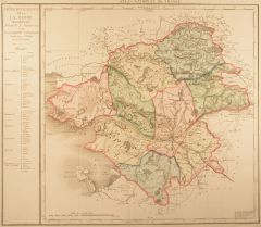 NANTES. - Karte. - Département de la La Loire Inferieure... en 9. Districts.
Altkol. Kupferstich bei J. B. Delaval, 1793, 50 x 50 cm.
Aus dem "Atlas National de France" der die 1790 neu geschaffenen 83 Departements darstellt. Die flächenkolorierte Karte zeigt die Umgebung von Blain, Chateau Briant, Ancenis, Clisso... (Artikelnr. 15690BG)
Erfahren Sie mehr133,00 € Inkl. MwSt. -
PYRÉNÉES-ATLANTIQUES. - Karte. - Département des Basses Pyrénnées, ci-devant le Béarn, la Basse Navarre et partie de la Gascogne.
Altkol. Aquatinta, um 1795, 16,5 x 21,5 cm.
Aus der Reihe: "Voyage dans les Departements de la France" von Joseph La Vallée, Marquis de Bois-Robert (1747 - 1816), Paris, 1793-1800. - Die Karte zeigt das Gebiet um Bayonne und Pau. (Artikelnr. 16800BG)
Erfahren Sie mehr48,00 € Inkl. MwSt. -
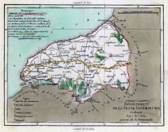 SEINE-MARITIME. - Karte. - Département de la Seine Inférieure, ci-devant Pays de Caux, partie de la Normandie.
Altkol. Aquatinta, um 1795, 16,5 x 21,5 cm.
Aus der Reihe: "Voyage dans les Departements de la France" von Joseph La Vallée, Marquis de Bois-Robert (1747 - 1816), Paris, 1793-1800. - Die Karte zeigt das Gebiet um Dieppe, Rouen und Le Havr... (Artikelnr. 16808BG)
Erfahren Sie mehr48,00 € Inkl. MwSt. -
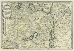
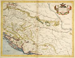 BALKAN. - Karte. - Sclavonia, Croatia, Bosnia cum Dalmatiae parte. Karte des westlichen Balkans.
Altkol. Kupferstich von Gerhard Mercator, um 1600, 36 x 46 cm.
Karte der heutigen Staaten Slowenien, Kroatien, Bosnien-Herzegowina und Serbien. Sie reicht im Norden bis zur Drau, im Süden bis zum Unterlauf der Drina, im Westen bis Ptuj un... (Artikelnr. 27180CG)
Erfahren Sie mehr380,00 € Inkl. MwSt. -
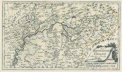
 BERRY. - Karte. - Regionis, Bitvrigvm exactiss: descriptio (31 x 31 cm) und "Limaniae Topographia".
Altkol. Kupferstich von Ortelius nach Chaumeau, um 1600, 31 x 48,5 cm.
Flächenkolorierte Karte des gesamten Gebiets mit altkolorierter Rollwerkkartusche und Wappen. Rechts Nebenkarte (31 x 15,5 cm) "Limaniae Topographia Gabriele Symeoneo ... (Artikelnr. 12551BG)
Erfahren Sie mehr120,00 € Inkl. MwSt. -
CHARENTE-MARITIME. - Karte. - Département de la Charente Inférieure, ci-devant Partie de la Saintonge et l'Aunis.
Altkol. Aquatinta, um 1795, 21,5 x 16,5 cm.
Aus der Reihe: "Voyage dans les Departements de la France" von Joseph La Vallée, Marquis de Bois-Robert (1747 - 1816), Paris, 1793-1800. - Die Karte zeigt das Gebiet um La Rochelle, Rochefort un... (Artikelnr. 16775BG)
Erfahren Sie mehr48,00 € Inkl. MwSt. -
CREUSE. - Karte. - Département de la Creuse, ci-devant partie de la Marche, du Berri et de l'Auvergne.
Altkol. Aquatinta, um 1795, 16,5 x 21,5 cm.
Aus der Reihe: "Voyage dans les Departements de la France" von Joseph La Vallée, Marquis de Bois-Robert (1747 - 1816), Paris, 1793-1800. - Die Karte zeigt das Gebiet um Guéret. (Artikelnr. 16779BG)
Erfahren Sie mehr48,00 € Inkl. MwSt. -
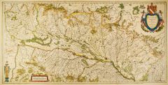
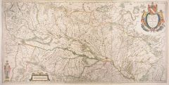 ELSASS. - Karte. - Alsatia Landgraviatus cum Suntgoia & Brisgoia.
Altkol. Kupferstich von Mercator, um 1620, 39 x 79 cm (von 2 Platten gedruckt).
Die nicht genordete Karte zeigt von links den Rheinlauf ab Basel bis Straßburg und bis Annweiler und Kaltenhausen auf der rechten Seite; das Elsass oben, der ... (Artikelnr. 13307AG)
Erfahren Sie mehr350,00 € Inkl. MwSt. -
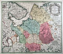 RUSSLAND. - Karte. - Mappae Imperii Moscovitici pars Septentrionalis / pars Australis.
2 altkol. Kupferstiche von M. Seutter, um 1740, je ca. 49,5 x 57 cm.
Die zweiteilige, flächenkolorierte Karte zeigt das Gebiet nördlich und südlich von Moskau mit dem Ladoga-See, Onega-See, die Halbinsel Kola und dem Weißen Meer im Nor... (Artikelnr. 18056BG)
Erfahren Sie mehr750,00 € Inkl. MwSt. -
ÖSTERREICH. - Karte. - Das Erzherzogthum Oesterreich ob- und unter der Enns. Karte von Ober- und Niederösterreich, mit Plan von Wien und Umgebung.
Grenzkol. Kupferstich nach Weiland, Weimar im Geograph. Institut, dat. 1842, 45,5 x 62,5 cm.
Espenhorst, PP 1.1.3. - Mit Farberklärungen für die Viertel: Wienerwald (2x), Mannhardsberge (2x), Mühl, Traun, Hausruck, Inn, Salzburg. - Unte... (Artikelnr. 633FG)
Erfahren Sie mehr120,00 € Inkl. MwSt. -
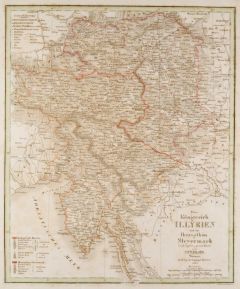 SLOWENIEN. - Karte. - Das Königreich Illyrien und das Herzogthum Steyermark. Karte von Steiermark, Kärnten, Istrien und Slowenien.
Grenzkol. Kupferstich von Maedel nach Weiland, Weimar im Geograph. Institut, dat. 1830, 37 x 31 cm.
Espenhost, PP 1.2.2. - Aus dem verkleinerten "Hand-Atlas ... für Bürgerschulen und Zeitungsleser" (sog. Bund-Ausgabe). - Seltener ("great... (Artikelnr. 33287EG)
Erfahren Sie mehr110,00 € Inkl. MwSt. -
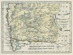
UNGARN. - Karte. - Galizien, Ungarn und Nebenländern.
Grenzkol. Kupferstich von Dekinder und Eyb aus Kiepert bei Reimer, Berlin, 1875, 45 x 54 cm.
Espenhorst, PP 20.1.2. - Aus: Heinrich Kiepert's "Neuer Handatlas über alle Theile der Erde" (Ausgabe 1875). - Berichtigt 1874. - Die Karte zeigt... (Artikelnr. 19042BG)
Erfahren Sie mehr90,00 € Inkl. MwSt. -
UNGARN. - Karte. - Galizien, Ungarn und Nebenländern.
Grenzkol. Kupferstich von Dekinder und Eyb aus Kiepert bei Reimer, Berlin, 1871, 45 x 54 cm.
Espenhorst, PP 20.1.2. - Aus: Heinrich Kiepert's "Neuer Handatlas über alle Theile der Erde" (Ausgabe 1871). - Berichtigt 1870. - Die Karte zeigt... (Artikelnr. 19089BG)
Erfahren Sie mehr90,00 € Inkl. MwSt. -
AZOREN. - Karte. - Atlantischer Ozean. Azoren Ost-Gruppe.
Kupferstich von F. Müllhaupt nach R. Enderich, Berlin, Reimer, 1918, 105 x 69 cm.
Vom Reichs-Marine-Amt herausgegebene Karte im Maßstab 1:150000 mit Angabe der Höhen und Tiefen in Metern. Sie zeigt die Inseln Sao Miguel und Santa Maria.... (Artikelnr. 15650BG)
Erfahren Sie mehr180,00 € Inkl. MwSt. -
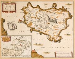 ISCHIA. - Karte. - Ischia Isola, olim Aenaria.
Altkol. Kupferstich von J. Janssonius, um 1640, 35,5 x 45,5 cm.
Schöne und seltene Gesamtkarte mit der Isola di Procida. Links unten Karte der Insel Elba (14 x 19 cm). Die Städte und wichtige Bauwerke wie Triumphbögen, Festungen, Türme... (Artikelnr. 27123CG)
Erfahren Sie mehr350,00 € Inkl. MwSt. -
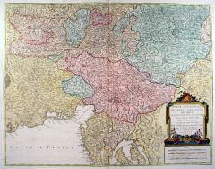 ITALIEN. - Norditalien. - Karte. - Partie méridionale du cercle d'Autriche, qui comprend la basse partie du duché de Stirie, le duché de Carinthie.
Altkol. Kupferstich von Delahaye bei R. de Vaugondy, dat. 1752, 47,5 x 61 cm.
Die flächenkolorierte Karte zeigt das Gebiet zwischen Graz (Norden), Luttenberg, die Insel Krk (Süden) und Linz. Mit altkolorierter Titelkartusche und Meilenze... (Artikelnr. 18039BG)
Erfahren Sie mehr228,00 € Inkl. MwSt. -
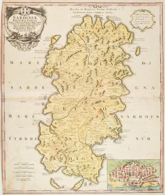 SARDINIEN. - Karte. - Sardiniae Regnum et Insula.
Altkol. Kupferstich nach P. Vincenzo Coronelli bei Homann Erben, dat. 1734, 58,5 x 49 cm.
Detaillierte Karte die auch die Inseln Tavolara, Sant Antioco, Sant Pietro, Asinara und die Meerenge von Bocche die Bonifacio zeigt. Mit altkoloriert... (Artikelnr. 27995CG)
Erfahren Sie mehr350,00 € Inkl. MwSt. -
 ARTOIS. - Karte. - Carte d'Artois, et des Environs; ou l'on voit le Ressort du Conseil provincial d'Artois
Altkol. Kupferstich von Guillaume Delisle, dat. 1704, 49 x 61 cm.
Die grenzkolorierte Karte zeigt das Gebiet von der belgischen Grenze bis zum Baie de la Somme. Die Städte sind rot hervorgehoben. - Mit schöner, figürlicher Kartusche obe... (Artikelnr. 2176GG)
Erfahren Sie mehr90,00 € Inkl. MwSt. -
 KÄRNTEN. - Karte. - Goritiae, Karstii, Chaczeolae, Carniolae, Histriae, et Windorvm Marchae Descrip.
Altkol. Kupferstich nach W. Lazius bei Abraham Ortelius, um 1575, 34 x 23 cm.
Van den Broecke 116b. - Die Karte zeigt Istrien, die Grafschaft Görz (Gorizia), Krain, und die Windische Mark sowie das nordwestliche Kroatien und die Inseln de... (Artikelnr. 2399GG)
Erfahren Sie mehr270,00 € Inkl. MwSt. -
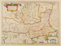 BALKAN. - Karte. - Walachia, Servia, Bulgaria, Romania. Karte des östlichen Balkans.
Altkol. Kupferstich von Gerhard Mercator, um 1600, 36 x 46 cm.
Karte der heutigen Staaten Serbien, Rumänien, Bulgarien und Türkei. Sie reicht im Norden bis Siret, im Süden bis Thessaloniki, im Westen bis Belgrad und Durres sowie im Oste... (Artikelnr. 27181CG)
Erfahren Sie mehr380,00 € Inkl. MwSt. -
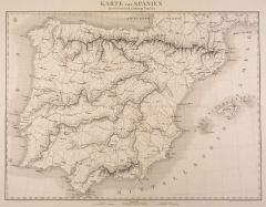
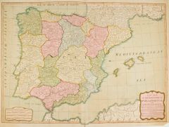 SPANIEN und PORTUGAL. - Karte. - A New Map of the Kingdoms of Spain and Portugal with their Principal Divisions.
Altkol. Kupferstich bei Laurie & Whittle, London, dat. 1794, 48 x 64 cm.
Die in England erschienene flächenkolorierte Karte zeigt die Iberische Halbinsel mit den Balearen und Gibraltar. - Mit hinterlegten Randeinrissen, unten einer bis in... (Artikelnr. 2673GG)
Erfahren Sie mehr250,00 € Inkl. MwSt. -
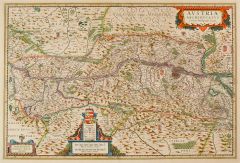 ÖSTERREICH. - Karte. - Austria archiducatus.
Altkol. Kupferstich von Blaeu nach Wolfgang Lazio, um 1630, 36,5 x 53 cm.
Karte von Ober- und Niederösterreich. Mit 3 kolorierten Kartuschen. (Artikelnr. 15330AG)
Erfahren Sie mehr350,00 € Inkl. MwSt. -
 UNGARN. - Karte. - Des Koenigreichs Ungarn östlicher Theil Nro. 32.
Grenzkol. Kupferstich von Reilly, um 1790, 20,5 x 35,5 cm.
Karte des Gebietes nördlich von Debrecin, mittig die Theiss und Szamos. (Artikelnr. 17764AG)
Erfahren Sie mehr70,00 € Inkl. MwSt. -
 UNGARN. - Karte. - Des Koenigreichs Ungarn westlicher Theil Nro 29.
Grenzkol. Kupferstich von Reilly, um 1790, 21,5 x 32 cm.
Karte des Gebietes zwischen Neusiedler und Plattensee, im Osten mit Budapest. (Artikelnr. 10359CG)
Erfahren Sie mehr80,00 € Inkl. MwSt. -
LOTHRINGEN. - Karte. - Des Ober Rheinischen Creisses Südlicher theil mit der Franche Comte und den gantzen Hertzogthum Lothringen.
Altkol. Kupferstich bei Weigel aus "Atlas Portatilis", Nürnberg, 1733, 16 x 14 cm.
Karte von Lothringen. Rechts unten Titelkartusche. (Artikelnr. 13346BG)
Erfahren Sie mehr48,00 € Inkl. MwSt. -
FRAUENFELD. - Karte. - Karte mit der Umgebung von Frauenfeld mit Uesslingen bis Bürglen und Bauma, Lichtensteig bis Mögelberg.
Kupferstich von Abel nach Ammann bei Cotta, um 1800, 43 x 37 cm. (Artikelnr. 14216AG)
Erfahren Sie mehr124,00 € Inkl. MwSt. -
 SPANIEN. - Karte. - Karte von Spanien. Zur Characteristik der Kriege Napoleons.
Lithographie bei Herder, Freiburg, um 1840, 38 x 51 cm.
Gesamtkarte mit den Balearen. - Sehr sauberes, breitrandiges Exemplar. (Artikelnr. 17336AG)
Erfahren Sie mehr52,00 € Inkl. MwSt. -
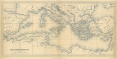 EUROPA. - Mittelmeer. - Karte. - The Mediterranean. Gesamtkarte mit den Anrainerländern.
Stahlstich von A. Findlay bei Fisher, London, dat. 1839, 19,5 x 39,5 cm.
Mit Einzeichnung aller Hafenstädte entlang der Küsten. (Artikelnr. 32621EG)
Erfahren Sie mehr75,00 € Inkl. MwSt. -
KARLSBAD. - Karte. - Karlsbad mit dem Gantzen Ellenbogner Creisse im Königreiche Böhmen.
Altkol. Kupferstich bei Weigel aus "Atlas Portatilis", Nürnberg, 1733, 14,5 x 19 cm.
Karte vom Ellenbogner Gebiet mit Titelkartusche rechts unten. (Artikelnr. 13303BG)
Erfahren Sie mehr95,00 € Inkl. MwSt. -
 UNGARN. - Karte. - Des Koenigreichs Ungarn ostsüdlicher Theil Nro. 33.
Grenzkol. Kupferstich von Reilly, um 1790, 21 x 28,5 cm.
Karte des Gebietes zwischen der Theiss im Westen und Maros im Süden. (Artikelnr. 17729AG)
Erfahren Sie mehr70,00 € Inkl. MwSt. -
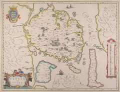 FÜNEN. - Karte. - Fionia vulgo Fynen.
Altkol. Kupferstich aus Janssonius, 1630, 37,5 x 49 cm.
Karte der Insel mit Alsen und Langeland. Mit altkol. Wappen und figürlicher, altkol. Titelkartusche. (Artikelnr. 14960AG)
Erfahren Sie mehr240,00 € Inkl. MwSt. -
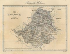 PRACHATITZ (Kreis). - Karte. - Der Prachiner Kreis. Karte.
Farblithographie von Geiger bei A. Leykum, Wien, 1840, 13 x 18,5 cm.
Nebehay-Wagner 509, 7. - Aus "Das pittoreske Österreich", Lieferung 7. (Artikelnr. 20064CG)
Erfahren Sie mehr110,00 € Inkl. MwSt. -
AISNE. - Karte. - Département de l'Aisne, ci-devant partie de l'Ile de France, de la Picardie et de la Brie.
Altkol. Aquatinta, um 1795, 21,5 x 16,5 cm.
Aus der Reihe: "Voyage dans les Departements de la France" von Joseph La Vallée, Marquis de Bois-Robert (1747 - 1816), Paris, 1793-1800. - Die Karte zeigt die Umgebung von Laon und Saint-Quentin... (Artikelnr. 16814BG)
Erfahren Sie mehr48,00 € Inkl. MwSt. -
FRANKREICH. - Südfrankreich. - Karte. - Bassin du Rhone. Karte der Provence mit Rhonemündung, nach Norden das Tal der Rhone und Saône.
Kupferstich von Jacobs nach Duvotenay aus Lavallée bei Furne, Paris, 1858, 35 x 20,5 cm.
Aus: Théophile Lavallée's "Atlas de Géographie Militaire". - Zeigt im Süden den Küstenverlauf von Sète (Cette) bis Ventimiglia, im Norden Chaum... (Artikelnr. 34859EG)
Erfahren Sie mehr60,00 € Inkl. MwSt. -
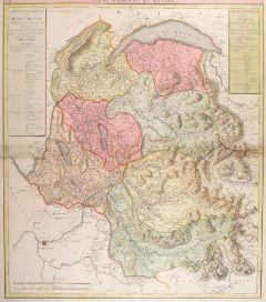 SAVOYEN. - Karte. - Département du Mont Blanc.
Altkol. Kupferstich bei J. B. Delaval, 1793, 59 x 51 cm.
Aus dem "Atlas National de France" der die 1790 neu geschaffenen 83 Departements darstellt. Das "Departement du Mont Blanc" ist erst später dazu gekommen (Nr. 85). Die Karte zeigt d... (Artikelnr. 14342CG)
Erfahren Sie mehr260,00 € Inkl. MwSt. -
SEINE-ET-MARNE. - Karte. - Département de Seine et Marne, ci-devant partie de l'Isle de France et de la Brie.
Altkol. Aquatinta, um 1795, 16,5 x 21,5 cm.
Aus der Reihe: "Voyage dans les Departements de la France" von Joseph La Vallée, Marquis de Bois-Robert (1747 - 1816), Paris, 1793-1800. - Die Karte zeigt die Umgebung von Melun, Meaux und Provi... (Artikelnr. 16807BG)
Erfahren Sie mehr48,00 € Inkl. MwSt. -
AUBE. - Karte. - Département de l'aube, ci-devant partie de la Champagne et de la Bourgogne.
Altkol. Aquatinta, um 1795, 16,5 x 21,5 cm.
Aus der Reihe: "Voyage dans les Departements de la France" von Joseph La Vallée, Marquis de Bois-Robert (1747 - 1816), Paris, 1793-1800. - Die Karte zeigt die Umgebung von Troyes. - Rechte obere... (Artikelnr. 16757BG)
Erfahren Sie mehr48,00 € Inkl. MwSt. -
 ELSASS. - Karte. - Alsatia Landgraviatus cum Suntgoia & Brisgoia.
Altkol. Kupferstich von Mercator, um 1620, 39 x 79 cm (von 2 Platten gedruckt).
Die nicht genordete Karte zeigt von links den Rheinlauf ab Basel bis Straßburg und bis Annweiler und Kaltenhausen auf der rechten Seite, das Elsass oben, der ... (Artikelnr. 25376CG)
Erfahren Sie mehr320,00 € Inkl. MwSt. -
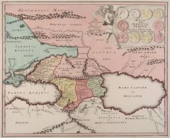 KASPISCHES MEER. - Karte. - Asia intra Maeotim Pontum et Mare Caspium.
Altkol. Kupferstich bei Chr. Weigel, 1718, 31 x 38 cm.
Aus: Johann David Köhlers "Bequemer Schul= und Reisen=Atlas", 1718. - Die historische Karte zeigt einen Teil des Schwarzen Meeres mit der Krim und das Kaspische Meer mit Wolgamündung... (Artikelnr. 18112CG)
Erfahren Sie mehr160,00 € Inkl. MwSt. -
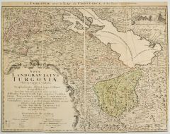 THURGAU und BODENSEE. - Karte. - La Turgovie avec le Lac de Constance. Bodensee mit dem Kanton Thurgau.
Altkol. Kupferstich von J.A. Rizzi-Zanoni bei Homann Erben, dat. 1766, 43 x 55 cm.
Gesuchte Karte der Kantone Thurgau, Schaffhausen und Appenzell, mit dem Bodensee im oberen Drittel. Mit großer Textkartusche, von Rocaillen eingerahmt und ... (Artikelnr. 27011CG)
Erfahren Sie mehr450,00 € Inkl. MwSt. -
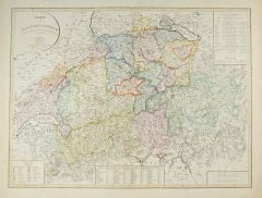 SCHWEIZ. - Karte. - Charte von Helvetien und Wallis. Nach den neuesten und vorzüglichsten Hülfsmitteln neu entworfen.
Altkol. Kupferstich von F. Götze bei Geographisches Institut, Weimar, dat. 1804, 44 x 59 cm.
Die flächenkolorierte Karte zeigt das Gebiet von Mühlhausen und Bodensee im Norden bis zum Lago Maggiore und Bergamo im Süden, im Westen von G... (Artikelnr. 1769GG)
Erfahren Sie mehr250,00 € Inkl. MwSt. -
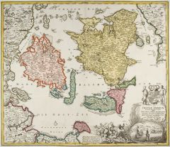 DÄNEMARK. - Karte. - Insvlae Danicae in Mari Balthico sitae, utpote Zeelandia, Fionia, Langelandia, Lalandia, Falstria, Fembria Mona.
Altkol. Kupferstich von J.B. Homann, um 1720, 48,5 x 57 cm.
Flächenkolorierte Karte der dänischen Ostseeinseln. Zeigt u.a. die Inseln Fünen, Langeland, Aero, Seeland, Falster, Lolland und Mon, sowie die deutsche Insel Fehrmarn. Rechts u... (Artikelnr. 27749CG)
Erfahren Sie mehr300,00 € Inkl. MwSt. -
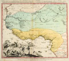 AFRIKA. - Westafrika. - Karte. - Guinea propria, nec non Nigritiae, vel Terrae Nigrorum maxima pars ... Aethiopia Inferior.
Altkol. Kupferstich von J.M. Hase bei Homann Erben, dat. 1743, 46 x 55 cm.
Zeigt Westafrika von der Atlantikküste Mauretaniens im Norden bis Equatorial Guinea im Süden. Eingezeichnet sind die Flußläufe im Inneren und die Stützpunkte d... (Artikelnr. 27327CG)
Erfahren Sie mehr550,00 € Inkl. MwSt. -
MÄHREN. - Karte. - Das Marckgraffthum Maehren mit seinen abgetheilten Creissen.
Altkol. Kupferstich bei Weigel aus "Atlas Portatilis", Nürnberg, 1733, 16 x 18,5 cm.
Karte von der Markgrafschaft Mähren mit Titelkartusche links oben. (Artikelnr. 13305BG)
Erfahren Sie mehr76,00 € Inkl. MwSt.