Suchergebnisse für: "europa karte"
-
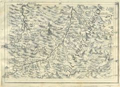
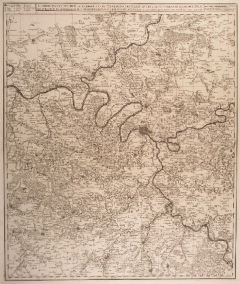
 LUZERN. - Karte. - Karte des Gebietes zwischen Huttwil, Sempacher und Zuger See bis Altdorf im Süden; im Mittelpunkt Luzern und der Vierwaldstätter See.
Kupferstich von Bodenehr nach J.C. Hurter, 1679, 17,5 x 24,5 cm. (Artikelnr. 8571CG)
Erfahren Sie mehr180,00 € Inkl. MwSt. -
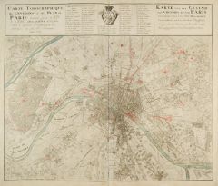 PARIS. - Karte von der Gegend und Grundris der Stadt Paris.
Kupferstich bei Homann Erben, 1739, 50 x 58 cm.
Schöner Grundrißplan mit gest. Erklärungen 1 - 63, Wappen und zweisprachigem Titel. (Artikelnr. 417CG)
Erfahren Sie mehr550,00 € Inkl. MwSt. -
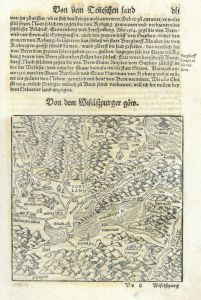 WAADT. - Karte. - Von dem Wifelspurger Göw. Mit Neuenburger-, Genfer- und Thuner See. Nicht genordete Karte.
Kol. Holzschnitt aus Seb. Münster, "Cosmographia", 1598, 15 x 15 cm (auf der ganzen Buchseite). (Artikelnr. 15314AG)
Erfahren Sie mehr140,00 € Inkl. MwSt. -
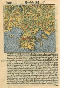
FRANKREICH. - Karte. - Gallia oder Franckreych.
Holzschnitt aus Stumpf, 1606, 28,5 x 40 cm.
Nicht genordete Karte. Am rechten Rand Kartusche, Wappen, Schiff und Seeungeheur. - Im Ganzen gebräunt, Rand beschnitten. (Artikelnr. 14507AG)
Erfahren Sie mehr142,00 € Inkl. MwSt. -
 ISTRIEN. - Karte. - Karte des Golfs von Triest mit der Gegend vom Friaul, Laibach bis Kroatien.
Kol. Holzschnitt aus Seb. Münster, "Cosmographia", um 1580, 14 x 16 cm.
Auf der ganzen Buchseite einer deutschen Ausgabe. (Artikelnr. 22762CG)
Erfahren Sie mehr150,00 € Inkl. MwSt. -
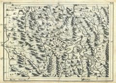
 LECHTALER ALPEN. - Karte. - Karte von Iller und Lech, vom Ursprung bis Sonthofen und Hindelang, rechts der Inn mit Imst und Nassereit.
Kupferstich von Johann Georg Bodenehr nach Johann Christoph Hurter, 1679, 18 x 24,5 cm. (Artikelnr. 378CG)
Erfahren Sie mehr180,00 € Inkl. MwSt. -
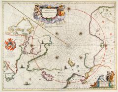 NORDPOL. - Karte. - Regiones sub Polol Arctico.
Altkolorierter Kupferstich bei W.J. Blaeu, um 1645, 41 x 53 cm.
Karte der Polargegend mit dem nördlichen Kanada, Grönland, Island, Lappland und dem nördlichen Russland. - Oben mittig altkolorierte Titelkartusche, links Wappenkartusche u... (Artikelnr. 26327CG)
Erfahren Sie mehr900,00 € Inkl. MwSt. -
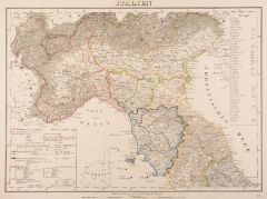
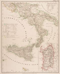
ITALIEN. - Norditalien. - Karte. - Karte des Lombardisch-Venetianischen Königreichs, mit Südtirol vom Gardasee bis zum Brenner, unten Inschrift, oben Provinzeinteilung und Erklärungen.
Grenzkol. Lithographie von Biller nach Fried bei Artaria, dat. 1866, 35,5 x 49 cm.
Karte der Lombardei und Venetiens, mit Begrenzung im Osten durch Illyrien, im Westen durch Ticino, im Süden durch Po. - Geglättete Längs- und Querfalten. (Artikelnr. 32576EG)
Erfahren Sie mehr100,00 € Inkl. MwSt. -
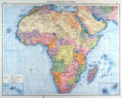 AFRIKA. - Karte. - Übersichtskarte von Afrika, mit der Arabischen Halbinsel. Mit zwei Nebenkarten.
Farblithographie nach Scrobel aus Andree bei Velhagen & Klasing, 1899, 36,5 x 46,5 cm.
Espenhorst, PP 5.1.4. - Aus: Richard Andree's "Allgemeiner Handatlas" (4. Ausgabe, Auflage 1899). - "Mit dieser Ausgabe wurde der ANDREE zum führenden ... (Artikelnr. 35042EG)
Erfahren Sie mehr95,00 € Inkl. MwSt. -
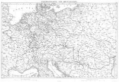 EUROPA. - Eisenbahn. - Karte. - Eisenbahnkarte von Mitteleuropa. Mitteleuropa mit den Bahnlinien.
Kupferstich von R. Schmidt nach G. Heck, 1845, 26 x 40,5 cm.
Zeigt das Gebiet von Südostengland bis Marseille, von Süddänemark bis in die Toskana, im Osten Kiew und das Schwarze Meer. (Artikelnr. 32997EG)
Erfahren Sie mehr94,00 € Inkl. MwSt. -
EUROPA. - Mittelmeer. - Karte. - Südeuropa und Mittelmeer. Verkehrskarte. Mit zwei Nebenkarten.
Farblithographie nach Scrobel aus Andree bei Velhagen & Klasing, 1900, 37,5 x 49,5 cm.
Espenhorst, PP 5.1.4. - Aus: Richard Andree's "Allgemeiner Handatlas" (4. Ausgabe, Auflage 1900). - Zeigt das Gebiet zwischen Irland und Dänemark im No... (Artikelnr. 737FG)
Erfahren Sie mehr110,00 € Inkl. MwSt. -
GRIECHENLAND. - Karte. - Karte von Griechenland.
Holzschnitt aus Seb. Münster, "Cosmographia", um 1590, 12,5 x 13 cm.
Recto und verso mit dem einleitenden Text "Griechen land nach seinen landschafften und allen Eigenschafften." - Auf der vollen Buchseite. (Artikelnr. 31849EG)
Erfahren Sie mehr98,00 € Inkl. MwSt. -
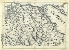 THURGAU. - Bodensee. - Karte. - Karte des Gebietes zwischen Eglisau, Stein, Meersburg, Buchhorn, Rorschach, St. Gallen bis zum Zürichsee; mit Winterthur, Frauenfeld, Bischofszell, Wil, Pfäffikon und dem Bodensee.
Kupferstich von Bodenehr nach J.C. Hurter, 1679, 17,5 x 24,5 cm. (Artikelnr. 8567CG)
Erfahren Sie mehr220,00 € Inkl. MwSt. -
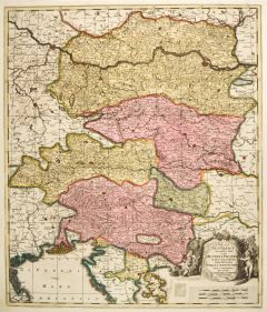
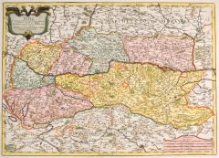 OBERÖSTERREICH. - Karte. - Arciducato d' Austria.
Altkol. Kupferstich von F. Donia nach Giacomo Cantelli bei de Rossi, dat. 1684, 40 x 56 cm.
Karte von Ober- und Niederösterreich mit dem Lauf der Donau von Passau bis Pressburg, im Norden mit Znaim, im Süden bis Graz reichend. Die Titelk... (Artikelnr. 27466CG)
Erfahren Sie mehr450,00 € Inkl. MwSt. -
 BALEAREN. - Karte. - Carte welche die Inseln Maiorca, Minorca, Yvica und Formentera nebst dem Grund Ris von dem Hafen Mahon und der Vestung St. Philip vorstellet. Zeigt die Balearen mit den Inseln Formentera, Menorca, Mallorca und Ibiza.
Kupferstich von Paul Küffner nach Bellin bei Felßecker, dat. 1756, 30 x 38 cm.
Die seltene Karte unten rechts mit Insetkarte (8 x 14,8 cm) der Bucht von Mahon mit Erklärungen von a - q, daneben Insetkarte (8,9 x 9,1 cm) der Balearen mit... (Artikelnr. 2633GG)
Erfahren Sie mehr1.400,00 € Inkl. MwSt. -
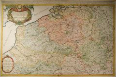
 BELGIEN. - Karte. - Des Burgundischen Creisses Südlicher theil oder Oesterreichische Nieder-lande.
Altkol. Kupferstich bei Weigel aus "Atlas Portatilis", Nürnberg, 1733, 15,5 x 16 cm.
Karte von Belgien und Luxemburg und den südlichen Niederlanden. Links oben Titelkartusche. (Artikelnr. 13344BG)
Erfahren Sie mehr48,00 € Inkl. MwSt. -
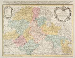
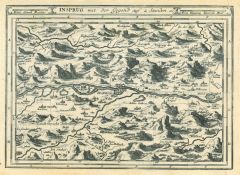 INNSBRUCK. - Karte. - Insprug mit der Gegend auf 2 Stunden.
Kupferstich von J. Stridbeck, um 1700, 16,5 x 23 cm.
Karte der Umgebung von Zirl bis Hall mit Einzeichnung der Orte als kleine Ansichten oder Grundrisse. (Artikelnr. 22050CG)
Erfahren Sie mehr140,00 € Inkl. MwSt. -
AFRIKA. - Westküste. - Karte. - Westliches Mittel-Africa Senegambien, Sudan, Ober-Guinea und einen Teil der Sahara. Gebietskarte, mit drei Nebenkarten.
Grenzkol. Kupferstich von Maedel und Bernhardt nach Weiland und Kiepert, Weimar im Geograph. Institut, dat. 1857, 50,5 x 66 cm.
Espenhorst, PP 1.1.5. - "Berichtigt 1849". Zeigt die Küstenländer von Kap Blanco (Mauretanien) bis Kap Lopez ... (Artikelnr. 33177EG)
Erfahren Sie mehr120,00 € Inkl. MwSt. -
ITALIEN. - Norditalien. - Karte. - Karte des Königreichs Lombardey-Venedig, mit Südtirol vom Gardasee bis Brixen, oben Inschrift, Provinzeinteilung und Erklärungen.
Grenzkol. Kupferstich von F. Fried bei Artaria, Wien, dat. 1824, 30,5 x 49,5 cm.
Karte der Lombardei und Venetiens, mit Begrenzung im Osten durch Illyrien, im Westen und Süden durch Ticino und Po. -Zwei alt hinterlegte Randläsuren, bei d... (Artikelnr. 594FG)
Erfahren Sie mehr130,00 € Inkl. MwSt. -
 PARIS. - Karte. - Carte Partivulire du Terroir et des Environs des Paris qui est la plus grande Partie de l'Isle de France.
Kupferstich von N. Visscher, um 1690, 57 x 48,5 cm.
Karte mit der Umgebung von Estampes im Süden bis Chantilly im Norden. Mit Kopftitel. (Artikelnr. 14330CG)
Erfahren Sie mehr160,00 € Inkl. MwSt. -
 LONDON. - Karte. - Accurater Grundriß u. Gegend der Koenigl. Großbrittanischen Haupt u. Residentz-Stadt London wie auch Prospect einiger Koenigl. Pallaeste u. Lust-Schlösser. Plan von London mit der Umgebung mit New Windsor, Watford, E
Altkol. Kupferstich von J.B. Homann, um 1720, 49 x 59 cm.
Schöne Karte des Großraums London mit dem Lauf der Themse. Rechts kleine Kartusche mit Neptun. - Alt auf Karton aufgezogen. Kräftiger Druck und schönes Altkolorit. (Artikelnr. 28448CG)
Erfahren Sie mehr1.200,00 € Inkl. MwSt. -
 RUSSLAND. - Karte. - Conspectus recens et accuratus magnae partis Lacus Ladogae et Sinus Finnici cum interjacentius et adjacentibg regionibus ad exemplar Petropolitanum.
Altkol. Kupferstich von Matthäus Seutter, um 1740, 50 x 57 cm.
Die grenzkolorierte Karte zeigt den Großraum von Sankt Petersburg mit dem östlichen Teil des Finnischen Meerbusen und dem südwestlichen Teil des Ladogasees, mit Einzeichnun... (Artikelnr. 2389GG)
Erfahren Sie mehr1.200,00 € Inkl. MwSt. -
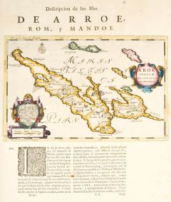 AARÖ. - Karte. - Aroe Insulae delineatio geometrica.
Altkol. Kupferstich von J. Blaeu, 1658, 19,5 x 30,5 cm.
Karte der im Kleinen Belt gelegenen Insel. Mit zwei schönen altkolorierten Kartuschen. Auf der vollen Seite mit der Beschreibung. (Artikelnr. 27053CG)
Erfahren Sie mehr280,00 € Inkl. MwSt. -
EUROPA. - Eisenbahn. - Karte. - Central Europe with Railways. Mitteleuropa mit den Bahnlinien.
Grenzkol. Kupferstich von J. Bartholomew bei A. Fullarton, London, um 1860, 41 x 51 cm.
Zeigt das Gebiet von Südostengland bis zu den Pyrenäen, von Süddänemark bis in die Toskana, im Osten Krakau und Budapest. (Artikelnr. 32994EG)
Erfahren Sie mehr128,00 € Inkl. MwSt. -
 SCHWEIZ. - Karte. - Helvetiae - Tirolis.
Kol. Kupferstich von J.B. Homann aus Scherer, "Geographia politica", um 1700, 23 x 35 cm.
Karte des Gebietes von Basel und Solothurn im Westen bis Lienz im Osten. Mit zwei wappenförmigen, kolorierten Kartuschen. Selten. (Artikelnr. 17949CG)
Erfahren Sie mehr180,00 € Inkl. MwSt. -
 ST. WOLFGANG. - Karte. - Orte der Salzach entlang von Salzburg bis Lueg, im Osten davon St. Wolfgang, darunter Felsenlandschaft mit Wind - Allegorie, Bergsteiger und Gemsen.
Kupferstich von Georg Philipp Finckh nach Philipp Apian, 1684, 18 x 23 cm.
Blatt 28 aus der großen Finckh-Karte in der revidierten Fassung von 1684. (Artikelnr. 5082AG)
Erfahren Sie mehr110,00 € Inkl. MwSt. -
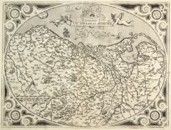
 LUXEMBURG. - Karte. - Les Provinces des Pays-Bas Catholiques, les Duchés de Brabant, Limbourg, Luxembourg, et partie de Gueldre, les Comtés de Flandre, Artois, Haynaut, le Marquisat du St. Empire.
Altkol. Kupferstich von Sanson & Jaillot, dat. 1689, 56 x 88 cm (von 2 Platten gedruckt).
Die großformatige, flächenkolorierte Karte zeigt Belgien, Brabant und Luxemburg. Im Südwesten mit Dieppe, im Norden Zeeland und der Niederrhein (M... (Artikelnr. 24791CG)
Erfahren Sie mehr600,00 € Inkl. MwSt. -
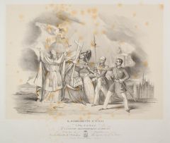 ITALIEN. - Nationalstaat. - Il Risorgimento d'Italia. Allegorische Darstellung auf die Einheit Italiens. Zeigt Papst Pius IX., eine antike Kriegerin und zwei Uniformierte, die den Papst mit einer Karte Italiens auf den Nationalstaat hinwe
Lithographie auf China von Martelli, Rom, 1847, 33 x 44,5 cm.
Als das "Risorgimento" bezeichnet man eine politische und gesellschaftliche Epoche in Italien, die nach dem Wiener Kongress von 1815 die Einheit Italiens als Nationalstaat zum Z... (Artikelnr. 42851EG)
Erfahren Sie mehr280,00 € Inkl. MwSt. -
AFRIKA. - Westküste. - Karte. - Westliches Mittel-Africa Senegambien, Sudan, Ober-Guinea und einen Teil der Sahara. Gebietskarte, mit drei Nebenkarten.
Grenzkol. Kupferstich von Maedel nach Weiland, Weimar im Geograph. Institut, dat. 1840, 50 x 65 cm.
Espenhorst, PP 1.1.3. - Zeigt "Die Stufenländer des mittlern Africa's und Nordrand von Hochafrica", von Kap Blanco (Mauretanien) bis Kap L... (Artikelnr. 682FG)
Erfahren Sie mehr108,00 € Inkl. MwSt. -
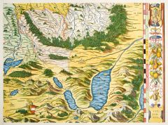 ATTERSEE. - Karte. - Karte des Gebietes um den Attersee mit dem Mattsee.
Kol. Holzschnitt nach Philipp Apian, 1568, 31 x 42 cm.
Vgl. Cartographia Bavariae S. 40-52. - Blatt 20 der 24-teiligen, nach Apian gestochenen Bayernkarte. Am rechten Rand mit Früchtegirlande. - Tadellos erhalten in sehr feinem Flächenko... (Artikelnr. 19352CG)
Erfahren Sie mehr950,00 € Inkl. MwSt. -
FRANKREICH. - Karte. - Karte von Frankreich. Mit Korsika.
Farblithographie nach Handtke bei Flemming, Glogau, um 1875, 65,5 x 78,5 cm.
Vgl. Espenhorst, PP S. 530, Illus. 4.13. - Aus: Carl Flemming's "Generalkarten. No. 28". - In 18 Segmente gefaltet. Im Rand mit Gebrauchsspuren. (Artikelnr. 32978EG)
Erfahren Sie mehr100,00 € Inkl. MwSt. -
SPANIEN und PORTUGAL. - Karte. - Karte von Spanien und Portugal, rechts die Balearen, unten Inschrift und Erklärungen.
Grenzkol. Kupferstich von R.v. Rothenburg nach A.H. Brué bei Artaria, Wien, dat. 1824, 36 x 49,5 cm.
Unten zwei alt hinterlegte Randeinrisse, bei den Ortsnamen z.T. Reste von Unterstreichungen mit Bleistift. (Artikelnr. 595FG)
Erfahren Sie mehr140,00 € Inkl. MwSt. -
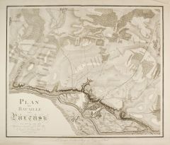 PULTUSK/Narew. - Karte. - Plan der Bataillevon Pultusk den 26ten Decembr. 1806.
Kupferstich von Carl Mare nach Both bei Schropp, Berlin, um 1810, 46 x 55 cm.
Karte des Gebietes um Pultusk mit eingezeichneten Truppenstellungen. - Mit hinterlegten Einrissen, rechts oben etwas knittrig. (Artikelnr. 2683GG)
Erfahren Sie mehr200,00 € Inkl. MwSt. -
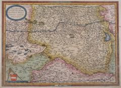
 NIEDERLANDE. - Karte. - Descriptio Germaniae inferioris.
Kupferstich von A. Ortelius bei Plantin, Antwerpen, 1572, 38 x 50,5 cm.
Karte von Holland mit Teilen der französischen Küste und vom Niederrhein. Mit dem Lauf von Mosel und dem Rhein von Köln bis zur Mündung. (Artikelnr. 27435CG)
Erfahren Sie mehr650,00 € Inkl. MwSt. -
 ÖSTERREICH. - Karte. - Circuli Austriaci Orientalior Pars.
Altkol. Kupferstich von G. Valk, um 1710, 58,5 x 49 cm.
Karte des östlichen Österreich mit Ober- und Niederösterreich, Steiermark und Kärnten sowie den südlichen Besitzungen bis Istrien. - Mit figürlicher Titelkartusche rechts unten.... (Artikelnr. 10132CG)
Erfahren Sie mehr280,00 € Inkl. MwSt. -
 ÖSTERREICH. - Karte. - Austria Ducatus chorographia, Wolfgango Lazio Auctore.
Altkol. Kupferstich nach W. Lazio bei Ortelius, um 1590, 34 x 46 cm.
Karte von Niederösterreich, Kärnten und der Steiermark. - Am linken und rechten Rand unten ca. 10 cm erneuert. Einfassungslinie etwas berieben. Schönes Altkolorit. (Artikelnr. 542BG)
Erfahren Sie mehr380,00 € Inkl. MwSt. -
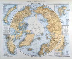 NORDPOL. - Karte. - Karte der Nordpolarregion. Mit vier Nebenkarten.
Farblithographie aus Andree bei Velhagen & Klasing, 1881, 36,5 x 46,5 cm.
Espenhorst, PP 5.1.1. - Aus: Richard Andree's "Allgemeiner Handatlas" (1. Ausgabe, Auflage 1881). - Die Nebenkarten zeigen Nowaja Semlja, Südwest-Grönland, Spitzbe... (Artikelnr. 35324EG)
Erfahren Sie mehr110,00 € Inkl. MwSt. -
 ITALIEN. - Norditalien. - Karte. - Karte von Norditalien bis Civita Vecchia und Aquila.
Grenzkol. Lithographie aus Sohr bei Flemming, Glogau, 1853, 30 x 41 cm.
Espenhorst, PP 4.1.1. - Aus: Karl Sohr's "Vollständiger Universal=Handatlas der neueren Erdbeschreibung". - Mit Angabe der politischen Einteilung und Zeichenerklärun... (Artikelnr. 18041CG)
Erfahren Sie mehr95,00 € Inkl. MwSt. -
 ITALIEN. - Süditalien. - Karte. - Karte von Süditalien mit Sizilien und Malta, rechts Nebenkarte von Sardinien.
Grenzkol. Lithographie aus Sohr bei Flemming, Glogau, 1853, 41 x 32 cm.
Espenhorst, PP 4.1.1. - Aus: Karl Sohr's "Vollständiger Universal=Handatlas der neueren Erdbeschreibung". - Mit Angabe der politischen Einteilung und Zeichenerklärun... (Artikelnr. 18040CG)
Erfahren Sie mehr95,00 € Inkl. MwSt. -
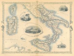 ITALIEN. - Süditalien. - Karte. - Southern Italy.
Grenzkol. Stahlstich von J. Rogers und J. Rapkin, um 1830, 24 x 32 cm.
Zeigt das südliche Italien mit Korsika, Sardinien und Sizilien. Mit Ansichten von Benevento und Neapel sowie zwei Szenen von einem Weinfest und dem Karneval. Die Karte... (Artikelnr. 20069CG)
Erfahren Sie mehr140,00 € Inkl. MwSt. -
SCHWEDEN. - Karte. - Dänemark und Süd=Schweden.
Grenzkol. Kupferstich von Ohmann und Barth aus Kiepert bei Reimer, Berlin, 1871, 44,5 x 54,5 cm.
Espenhorst, PP 20.1.2. - Aus: Heinrich Kiepert's "Neuer Handatlas über alle Theile der Erde" (Ausgabe 1871). - Berichtigt 1870. - Die dekorat... (Artikelnr. 19101BG)
Erfahren Sie mehr80,00 € Inkl. MwSt. -
SCHWEDEN. - Karte. - Dänemark und Süd=Schweden.
Grenzkol. Kupferstich von Ohmann und Barth aus Kiepert bei Reimer, Berlin, 1875, 44,5 x 54,5 cm.
Espenhorst, PP 20.1.2. - Aus: Heinrich Kiepert's "Neuer Handatlas über alle Theile der Erde" (Ausgabe 1875). - Berichtigt 1874. - Die dekorat... (Artikelnr. 19047BG)
Erfahren Sie mehr80,00 € Inkl. MwSt. -
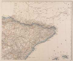 SPANIEN. - Nordostspanien. - Karte. - Karte von dern Pyrennäen bis Villareal im Süden, im Westen bis Deba an der Küste und Soria.
Grenzkol. Lithographie aus Sohr bei Flemming, Glogau, 1853, 30 x 35 cm.
Espenhorst, PP 4.1.1. - Aus: Karl Sohr's "Vollständiger Universal=Handatlas der neueren Erdbeschreibung". - Im Rand gering stockfleckig. (Artikelnr. 18060CG)
Erfahren Sie mehr70,00 € Inkl. MwSt. -
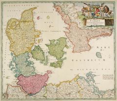 DÄNEMARK. - Karte. - Regni Daniae in quo sunt Ducatus Holsatiae et Slesviucum Insulae Danicae, Provinciae Jutia Scania Blekingia.
Altkol. Kupferstich von J.B. Homann, um 1720, 49 x 58 cm.
Karte des westlichen Ostseeraums mit Südschweden und der Küste von Mecklenburg und Pommern. Mit großer kolorierter figürlicher Kartusche rechts oben. (Artikelnr. 26319CG)
Erfahren Sie mehr300,00 € Inkl. MwSt. -
 ORLEANS. - Karte. - Nouvelle Carte du Gouvernement General et Militair d'Orleans.
Altkol. Kupferstich von Rizzi-Zanoni bei Homann Erben, 1762, 42 x 55 cm.
Karte des Gouvernements Orleans mit dem Lauf der Loire von Tours bis La Charité. - Titelkartusche rechts oben, links Meilenzeiger. Mit Kopftitel. (Artikelnr. 418CG)
Erfahren Sie mehr180,00 € Inkl. MwSt. -
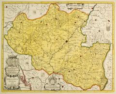 ARAGON. - Karte. - Aragonia Regnum.
Altkol. Kupferstich nach J.B. Lavanha von Petrus Schenk & Gerard Valck, um 1700, 42 x 52 cm.
Karte des Gebietes des ehemaligen Königreichs Aragon. Mit Ariza, Lerida, Villahermosa und Pamplona. Unten große Wappenkartusche und Widmung mit ... (Artikelnr. 27329CG)
Erfahren Sie mehr240,00 € Inkl. MwSt. -
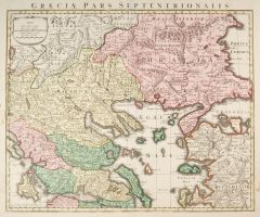 GRIECHENLAND. - Karte. - Graeciae Pars Septentrionalis.
Altkol. Kupferstich von Tobias Conrad Lotter, um 1760, 47 x 58 cm.
Zeigt Griechenland um das Ägäische Meer ohne den Peloponnes und mit der westlichen Türkei. - Mit Kopftitel. Kräftiges altes Kolorit. - Seitlich, außerhalb der Darstell... (Artikelnr. 2362GG)
Erfahren Sie mehr350,00 € Inkl. MwSt. -
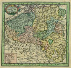
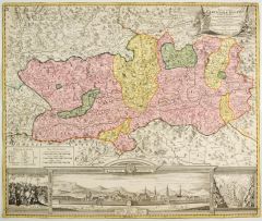 KÄRNTEN. - Karte. - Nova et accurata Carinthiae Ducatus.
Altkol. Kupferstich von J.B. Homann, um 1740, 49 x 58 cm.
Karte von Kärnten mit großer Gesamtansicht von Klagenfurt im unteren Rand (11 x 36 cm), links und rechts davon zwei weitere Ansichten. - Auf Einfassungslinie geschnitten. Schönes... (Artikelnr. 27320CG)
Erfahren Sie mehr380,00 € Inkl. MwSt. -
DÄNEMARK. - Karte. - Dania Regnum in quo sunt Ducatus Holsatia et Slesvicum Insulae Danicae et Provinciae Jutia Scania etc.
Altkol. Kupferstich von Frederik de Wit, um 1680, 50 x 58 cm.
Karte des westlichen Ostseeraums mit Südschweden und der Küste von Mecklenburg und Pommern mit Rügen. Mit figürlicher, altkolorierter Wappenkartusche rechts oben. (Artikelnr. 27068CG)
Erfahren Sie mehr450,00 € Inkl. MwSt. -
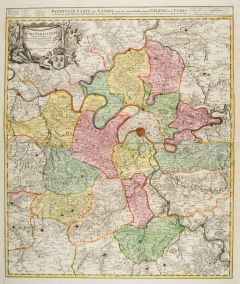 PARIS. - Karte. - Particulir Carte des Landes und der Schön-Weltberühmte Gegend umb Paris.
Altkol. Kupferstich von Johann Baptist Homann, um 1720, 57,5 x 48,5 cm.
Karte mit der Umgebung von Estampes im Süden bis Chantilly im Norden. Mit Kopftitel und Titelkartusche links oben. - Schönes, kräftiges altes Flächenkolorit. (Artikelnr. 24696CG)
Erfahren Sie mehr250,00 € Inkl. MwSt.