Suchergebnisse für: "europa karte"
-
 ARAGON. - Karte. - Novissima Arragoniae Regni Tabula.
Altkol. Kupferstich nach Joao Baptista Lavanha von Hendrik Hondius, um 1620, 45 x 55 cm.
Karte des Gebietes des ehemaligen Königreichs Aragon. Mit Ariza, Lerida, Villahermosa und Pamplona. Links oben Titelkartusche, unten Kartusche mit Wi... (Artikelnr. 27319CG)
Erfahren Sie mehr280,00 € Inkl. MwSt. -
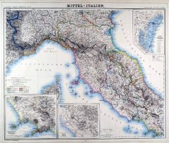 ITALIEN. - Mittelitalien. - Karte. - Mittel-Italien.
Grenzkol. Lithographie von Sulzer und Grack aus Kiepert bei Reimer, Berlin, 1871, 47 x 56,5 cm.
Espenhorst, PP 20.1.2. - Aus: Heinrich Kiepert's "Neuer Handatlas über alle Theile der Erde" (Ausgabe 1871). - Berichtigt 1870. - Die schöne ... (Artikelnr. 19094BG)
Erfahren Sie mehr120,00 € Inkl. MwSt. -
ITALIEN. - Mittelitalien. - Karte. - Mittel-Italien.
Grenzkol. Lithographie von Sulzer und Grack aus Kiepert bei Reimer, Berlin, 1875, 47 x 56,5 cm.
Espenhorst, PP 20.1.2. - Aus: Heinrich Kiepert's "Neuer Handatlas über alle Theile der Erde" (Ausgabe 1875). - Berichtigt 1874. - Die schöne ... (Artikelnr. 19067BG)
Erfahren Sie mehr120,00 € Inkl. MwSt. -
 OBERÖSTERREICH. - Karte. - Karte des Gebietes zwischen dem Inn im Westen, der Donau im Norden, Pöchlarn und Bruck im Osten sowie Lienz im Süden, die oberösterreichischen Seen im Mittelpunkt.
Grenzkol. Kupferstich, um 1800, 40 x 54 cm (breiter Rand).
Die Donau im Norden, im Westen Attersee, im Süden Hallstädter See, im Osten Waidhofen. (Artikelnr. 14351CG)
Erfahren Sie mehr170,00 € Inkl. MwSt. -
 GROSSBRITANNIEN. - Mittelengland. - Karte. - West Morlandia, Lan.Castria, Cestria, Caernaruan, Denbigh, Flint, Merionidh, Montgomery ... cum Insulis Mania et Anglesey.
Kupferstich von Gerhard Mercator, um 1580, 36 x 42 cm.
Karte der Westküste Mittelenglands mit Liverpool im Zentrum und der Isle of Man. Große Titelkartusche links, Fischungeheuer im Kartenbild. - Unten kleine restaurierte Fehlstelle. (Artikelnr. 25686CG)
Erfahren Sie mehr300,00 € Inkl. MwSt. -
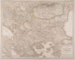 BALKAN. - Karte. - Die Europaeische Türkei - hauptsächlich nach H. Kieperts Karte.
Grenzkol. Kupferstich von Kratz und Jungmann nach Stülpnagel und Berghaus aus Stieler bei Perthes, Gotha, dat. 1856, 33 x 42 cm.
Aus: A. Stieler's "Hand-Atlas". - Zeigt das Gebiet von Bosnien, Serbien und der Walachei bis zum Schwarzen Me... (Artikelnr. 18022CG)
Erfahren Sie mehr80,00 € Inkl. MwSt. -
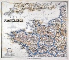 FRANKREICH. - Karte. - Karte von Frankreich in 4 Blättern. Gesamtkarte in 4 Blättern.
4 Stahlstiche mit Farblithographie nach Ravenstein aus Meyer bei BI, um 1865, je 30 x 36 cm.
Espenhorst, PP 3.4 (Meyer-Ravenstein 1862-1884). - Aus: Joseph Meyer's "Hand-Atlas", redigiert von Ludwig Ravenstein (1838-1915). - Mit 4 Nebenkar... (Artikelnr. 19335BG)
Erfahren Sie mehr280,00 € Inkl. MwSt. -
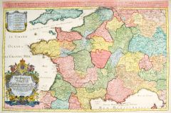 FRANKREICH. - Karte. - Le Royaume de France en Toutes ses Provinces. Gesamtkarte.
Altkol. Kupferstich von S.G. Hipschmann nach S. Sanson bei J. Hoffmann, Nürnberg, um 1680, 57 x 87 cm.
Thieme-Becker Bd. XVII, S. 126 (Hipschmann). - Landkarten des Nürnberger Kupferstechers Samuel Gabriel Hipschmann (1639 bis nach 1680)... (Artikelnr. 26665CG)
Erfahren Sie mehr650,00 € Inkl. MwSt. -
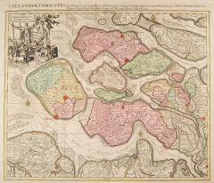 ZEELAND (Grafschaft). - Karte. - Zeelandiae Comitatus novissima et accuratissima delineatione mappa Geographica repraesentatus.
Altkol. Kupferstich von Tobias Conrad Lotter, um 1755, 47,5 x 57 cm.
Karte der Grafschaft Zeeland mit der Scheldemündung, von Vlissingen, Middelburg bis Bergen op Zoom bzw. Sandvliet. Mit maritimer Staffage und Titelei. - Unten mit schmal... (Artikelnr. 1857GG)
Erfahren Sie mehr550,00 € Inkl. MwSt. -
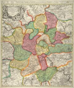 PARIS. - Karte. - Particulir Carte des Landes und der Schön-Weltberühmte Gegend umb Paris.
Altkol. Kupferstich von J.B. Homann, um 1720, 57,5 x 48,5 cm.
Karte mit der Umgebung von Estampes im Süden bis Chantilly im Norden. Mit Kopftitel und Titelkartusche links oben. - Ränder mit kleinen, nicht störenden Einrissen. Schönes, ... (Artikelnr. 14329CG)
Erfahren Sie mehr240,00 € Inkl. MwSt. -
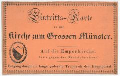 ZÜRICH. - Eintrittskarte Großmünster. - Eintritts-Karte in die Kirche zum Grossen Münster. Verschiedene Typographien, unten links ein Wappen, mit Zierbordüre.
Lithographie auf ziegelrot gekreidetem Papier, verso dat. 1832, 6,5 x 10 cm.
Auf die Emporkirche. Seite gegen das Oberstpfarrhaus. Eingang durch die lange gedeckte Treppe ob dem Hauptportal. Verso dat. von alter Hand "29 April 1832". (Artikelnr. 30620EG)
Erfahren Sie mehr60,00 € Inkl. MwSt. -
POLEN. - Karte. - Karte von den Königl. Preussischen Provinzen Preussen und Posen nebst dem Kaiserlich Russischen Königreiche Polen und dem Gebiete der freien Stadt Krakau. Mit Umgebungskarten von Königsberg, Danzig und Warschau.
Grenzkol. Kupferstich nach Weiland, Weimar im Geograph. Institut, dat. 1840, 54,5 x 50 cm.
Espenhost, PP 1.1.5. - Zeigt das Gebiet von Memel bis Krakau bzw. von Landsberg/Warthe bis Brest-Litowsk. Mit Farbangaben. (Artikelnr. 33142EG)
Erfahren Sie mehr160,00 € Inkl. MwSt. -
 VENEDIG. - Karte. - Veronae, Vicentiae et Patavii dictiones.
Altkol. Kupferstich bei G. Mercator, 1619, 37 x 49,5 cm.
Karte des Territoriums der früheren Republik Venedig. Im Norden und Westen bis nördlich des Garda Sees und Bassan, im Süden bis zum Po, im Osten bis zur Lagune von Venedig. - Rech... (Artikelnr. 28144CG)
Erfahren Sie mehr380,00 € Inkl. MwSt. -
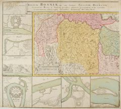 JUGOSLAWIEN. - Karte. - Regnum Bosniae, una cum finitimis Croatiae, Dalmatiae, Regni Serviae pars una finitimis Valachiae & Bulgariae, Slavoniae, Hung. et Serviae partibus.
Altkol. Kupferstich bei Homann Erben, um 1735, 51 x 111 cm (von zwei Platten gedruckt).
Seltene, übergroße Karte, die auf beiden Seiten und unten von 15 Festungsplänen umgeben ist, darunter Brodt, Wihaz, Zwornek (Ansicht), Ratscha, Saba... (Artikelnr. 9818AG)
Erfahren Sie mehr950,00 € Inkl. MwSt. -
 VENEDIG. - Karte. - Dominio Venetio Nell' Italia.
Kupferstich von Willem Janszoon Blaeu, um 1635, 38 x 50 cm.
Karte des Territoriums der Republik Venedig. Im Norden bis Villach und Meran reichend, im Süden bis Ravenna, Im Westen bis zum Comer See und im Osten bis Laibach und Fiume. Oben ... (Artikelnr. 27315CG)
Erfahren Sie mehr480,00 € Inkl. MwSt. -
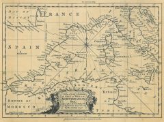 EUROPA. - Mittelmeer. - Karte. - A New Chart Exhibiting the Seat of War in the Mediterrenean Sea.
Kupferstich von Kitchin bei Baldwin, 1756, 16,5 x 23 cm.
Zeigt das Mittelmeer von Gibraltar bis Sizilien. (Artikelnr. 22859CG)
Erfahren Sie mehr120,00 € Inkl. MwSt. -
 FRANKREICH. - Karte. - Karte mit den Gebieten von Lothringen, den Herzogthümern Barrois und Champagne. Zeigt das Gebiet zwischen Ponta Mousson und Chaalons im Norden, im Westen Luistre und Piney, um Süden La Ferte und Darney, im Osten M
Grenzkol. Kupferstich von G. F. Abel bei J. G. Jaennicke für W. Jaeger, um 1780, 47 x 62 cm.
Blatt 56 der "Carte Topographique d'Allemagne". (Artikelnr. 11875AG)
Erfahren Sie mehr114,00 € Inkl. MwSt. -
 FRANKREICH. - Karte. - Karte mit den Gebieten von Lothringen, den Herzogthümern Barrois und Champagne. Zeigt das Gebiet zwischen Ponta Mousson und Chaalons im Norden, im Westen Luistre und Piney, um Süden La Ferte und Darney, im Osten M
Kupferstich von G. F. Abel nach J. G. Jaennicke bei W. Jaeger, um 1780, 47 x 62 cm.
Blatt 56 der "Carte Topographique d'Allemagne". (Artikelnr. 11876AG)
Erfahren Sie mehr114,00 € Inkl. MwSt. -
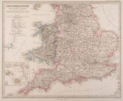 GROSSBRITANNIEN. - Karte. - Grossbritannien, Südliches Blatt: England (ohne die nördl. Grafschaften) u. Wales und "Grossbritannien. Nördliches Blatt: Schottland u. der nördlichste Theil England's".
2 grenzkol. Kupferstiche von Poppey und Jungmann nach Petermann aus Stieler bei Perthes, Gotha, dat. 1862, je 33 x 41 cm.
Aus: A. Stieler's "Hand-Atlas". - Das südliche Blatt mit Nebenkarte der Kanalinseln, das nördliche mit Nebenkarte d... (Artikelnr. 18035CG)
Erfahren Sie mehr110,00 € Inkl. MwSt. -
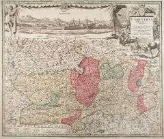 KÄRNTEN. - Karte. - Carinthia Ducatus distincta in Superiorem et Inferior ... Archiep Saliburgens. et Episcop. Bambergensis.
Altkol. Kupferstich von Seutter, um 1740, 48,5 x 57 cm.
Karte von ganz Kärnten und dem Erzbistum Salzburg. Umfasst das Gebiet zwischen Zell am See und Windisch-Grätz, Grundlsee bis Tarviso. Oben in einem Bühnenvorhang von Engel und Rabe... (Artikelnr. 13170AG)
Erfahren Sie mehr420,00 € Inkl. MwSt. -
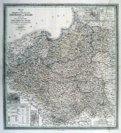 POLEN. - Karte. - Karte von den Königl. Preussischen Provinzen Preussen und Posen nebst dem Kaiserlich Russischen Königreiche Polen und dem Gebiete der freien Stadt Krakau. Mit Umgebungskarten von Königsberg, Danzig und Warschau.
Grenzkol. Kupferstich von Mädel nach Weiland, Weimar im Geograph. Institut, dat. 1840, 54,5 x 49,5 cm.
Espenhost, PP 1.1.3. - Zeigt das Gebiet von Memel bis Krakau bzw. von Landsberg/Warthe bis Brest-Litowsk. - Rechts wasserrandig bis in ... (Artikelnr. 646FG)
Erfahren Sie mehr140,00 € Inkl. MwSt. -
FRANKREICH. - Karte. - General-Karte von Frankreich nach den neuesten u. besten Quellen bearbeitet. Gesamtkarte in vier Teilen, auf insgesamt vier Blättern.
4 grenzkol. Lithographien nach Handtke aus Sohr bei Flemming, Glogau, dat. 1850, je ca. 33 x 39 cm.
Espenhorst, PP 4.1.1. - Aus: Karl Sohr's "Vollständiger Universal=Handatlas der neueren Erdbeschreibung". - Mit Grenzkolorit für die 86 D... (Artikelnr. 35236EG)
Erfahren Sie mehr180,00 € Inkl. MwSt. -
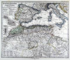 EUROPA. - Mittelmeer. - Karte. - Das Mittelländische Meer und Nord-Afrika (Westliches Blatt), mit Portugal, Spanien und Italien.
Grenzkol. Kupferstich von Poppey und Jungmann nach Petermann aus Stieler bei Perthes, Gotha, 1875, 33,5 x 40,5 cm.
Espenhorst, PP 2.1.1.1.6. - Aus: A. Stieler's "Hand-Atlas" (6. Ausgabe, Auflage 1875). - Im Süden Marokko, Algerien, Tunesi... (Artikelnr. 35362EG)
Erfahren Sie mehr90,00 € Inkl. MwSt. -
GALIZIEN. - Karte. - Karte des Königreiches Galizien. Gesamtkarte in zwei Teilen, auf Blatt eins links unten Inschrift mit Kreiseinteilung, auf Blatt zwei rechts oben Erklärungen.
Mehrfarbendrucke in Typometrie von F. Raffelsberger bei J. Bermann, Wien, 1841, je ca. 46 x 34,5 cm.
Aus "Austria. Erster Typometrischer Atlas für Geschäftsleute jeder Art, Gymnasien, Schulen und Zeitungsleser", Wien, 1841 bzw, 1843. - G... (Artikelnr. 576FG)
Erfahren Sie mehr180,00 € Inkl. MwSt. -
 ITALIEN. - Norditalien. - Karte. - Sedes Belli in Italia, Comprehendens Ducatus Mediolanensem, Parmensem ac Genuensem....
Altkol. Kupferstich von P. Schenk, um 1710, 56 x 94 cm (von zwei Platten gedruckt).
Zeigt Norditalien von Savoyen bis zum Golf von Venedig und von Trient bis La Spezia. Mit dem Lauf des Po und den oberitalienischen Seen. - Mit Kopftitel un... (Artikelnr. 24839CG)
Erfahren Sie mehr780,00 € Inkl. MwSt. -
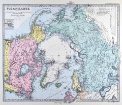 NORDPOL. - Karte. - Polar-Karte enthaltend: die Länder u. Meere vom Nord-Pol bis 50° N.Br. u. weiter, sowie Übersicht des Russischen Reiches, mit Grönland, Kanada und Alaska.
Farblithographie von Poppey nach Berghaus aus Stieler bei Perthes, Gotha, 1875, 32 x 38 cm.
Espenhorst, PP 2.1.1.1.6. - Aus: A. Stieler's "Hand-Atlas" (6. Ausgabe, Auflage 1875). - Mit Nebenkarte "Erebus & Terror Bay in Nord Devon. Winter ... (Artikelnr. 35359EG)
Erfahren Sie mehr95,00 € Inkl. MwSt. -
EUROPA. - Eisenbahn. - Karte. - Central Europe, showing the Principal Railways and the Political Boundaries. Mitteleuropa mit den Bahnlinien.
Farblithographie von Ed. Weller bei Blackie, London, um 1880, 34,5 x 50 cm.
Zeigt das Gebiet von Südostengland bis zur Dordogne, von Süddänemark bis Venedig, im Osten Warschau und Temesvar. (Artikelnr. 33082EG)
Erfahren Sie mehr88,00 € Inkl. MwSt. -
EUROPA. - Mittelmeer. - Karte. - Verkehrskarte der Mittelmeerländer, Westliche Hälfte. Verkehrskarte der Mittelmeerländer, Östliche Hälfte. Zwei Karten mit je einer Nebenkarte, auf insgesamt zwei Blättern.
2 Farblithographien nach Scrobel aus Andree bei Velhagen & Klasing, 1893, je ca. 23 x 37 cm.
Espenhorst, PP 5.1.3. - Aus: Richard Andree's "Allgemeiner Handatlas" (3. Ausgabe, Auflage 1893). - Zeigt das Gebiet zwischen den Alpen bzw. dem K... (Artikelnr. 35548EG)
Erfahren Sie mehr110,00 € Inkl. MwSt. -
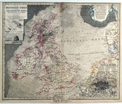
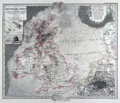 GROSSBRITANNIEN. - Karte. - Die Britischen Inseln und das umliegende Meer. Gesamtkarte mit der Nordsee und den Gegenküsten im Osten. Mit Ansicht der Felseninsel "Rockall" und vier Nebenkarten.
Grenzkol. Kupferstich von Poppey nach Petermann aus Stieler bei Perthes, Gotha, 1875, 33,5 x 40 cm.
Espenhorst, PP 2.1.1.1.6. - Aus: A. Stieler's "Hand-Atlas" (6. Ausgabe, Auflage 1875). - Die Küstenlinie reicht von Norwegen bis zu den Ka... (Artikelnr. 35376EG)
Erfahren Sie mehr110,00 € Inkl. MwSt. -
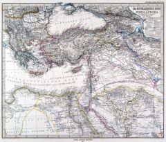 EUROPA. - Mittelmeer. - Karte. - Das Mittelländische Meer und Nord-Afrika (Öestliches Blatt), mit dem gesamten Osmanischen Reich. Mit Nebenkarte.
Grenzkol. Kupferstich von Poppey und Jungmann nach Habenicht aus Stieler bei Perthes, Gotha, 1875, 33,5 x 40 cm.
Espenhorst, PP 2.1.1.1.6. - Aus: A. Stieler's "Hand-Atlas" (6. Ausgabe, Auflage 1875). - Die Nebenkarte zeigt "Das Nil-Delta u... (Artikelnr. 35363EG)
Erfahren Sie mehr95,00 € Inkl. MwSt. -
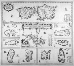 EUROPA. - Mittelmeer. - Karte. - Die Inseln Sardinien und Korsika. Die Inseln der Ägäis. Insgesamt zwei Darstellungen auf einem Blatt.
Kupferstich nach J. Janssonius bzw. A. Ortelius bei Pierre de Hondt, Den Haag, 1741, 14 x 48,5 cm bzw. 28,5 x 48,5 cm.
Aus "Georg Horn, Description exacte de l'Univers: ou l'ancienne Geographie" etc. - Die Inseln der Ägäis auf neun Einze... (Artikelnr. 31281EG)
Erfahren Sie mehr350,00 € Inkl. MwSt. -
 GROSSBRITANNIEN. - Karte. - Die Britischen Inseln und das umliegende Meer. Gesamtkarte mit der Nordsee und den Gegenküsten im Osten. Mit Ansicht der Felseninsel "Rockall" und vier Nebenkarten.
Grenzkol. Kupferstich von Poppey nach Petermann aus Stieler bei Perthes, Gotha, 1866, 34,5 x 40 cm.
Espenhorst, PP 2.1.1.1.4. - Aus: A. Stieler's "Hand-Atlas" (4. Ausgabe, Auflage 1866). - Die Küstenlinie reicht von Norwegen bis zu den Ka... (Artikelnr. 34899EG)
Erfahren Sie mehr120,00 € Inkl. MwSt. -
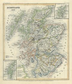 SCHOTTLAND. - Karte. - Schottland 1849.
Grenzkol. Stahlstich aus Meyer's Zeitungsatlas, 1853, 23,5 x 20 cm.
Mit zwei kleinen Karten der Shetland-Inseln und Orkney-Inseln. (Artikelnr. 140AG)
Erfahren Sie mehr50,00 € Inkl. MwSt. -
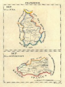 PYRENÄEN. - Karte. - Dep: der Ostpyrenaeen und Dep: des Jura. Zwei Karten übereinander.
Grenzkol. Lithographie von Hermann bei Schlieben, 1829, 26 x 19 cm. (Artikelnr. 18725AG)
Erfahren Sie mehr68,00 € Inkl. MwSt. -
76,00 € Inkl. MwSt.
-
60,00 € Inkl. MwSt.
-
19,00 € Inkl. MwSt.
-
57,00 € Inkl. MwSt.
-
38,00 € Inkl. MwSt.
-
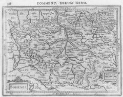 BÖHMEN. - Karte. - Bohemia.
Kupferstich von Bertius, 1616, 14,5 x 19 cm.
Gesamtkarte mit Prag im Mittelpunkt. (Artikelnr. 11525CG)
Erfahren Sie mehr95,00 € Inkl. MwSt. -
38,00 € Inkl. MwSt.
-
33,00 € Inkl. MwSt.
-
43,00 € Inkl. MwSt.
-
48,00 € Inkl. MwSt.
-
38,00 € Inkl. MwSt.
-
38,00 € Inkl. MwSt.