Suchergebnisse für: "europa karte"
-
38,00 € Inkl. MwSt.
-
60,00 € Inkl. MwSt.
-
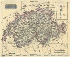 SCHWEIZ. - Karte. - Die Schweiz. Gesamtkarte.
Grenzkol. Stahlstich aus Galletti bei Hartleben, 1840, 20 x 25 cm.
Espenhorst, PP 45.1.1. - Aus: J.G.A. Galletti's "Allgemeine Weltkunde" (9. Ausgabe 1840). - Fünf Karten "neu gestochen von F(ranz) Biller ... wunderschön von Hand kolorie... (Artikelnr. 19239BG)
Erfahren Sie mehr65,00 € Inkl. MwSt. -
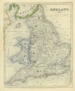 GROSSBRITANNIEN. - Karte. - England 1850.
Grenzkol. Stahlstich aus Meyer's Zeitungsatlas, 1853, 26 x 20,5 cm. (Artikelnr. 17266AG)
Erfahren Sie mehr57,00 € Inkl. MwSt. -
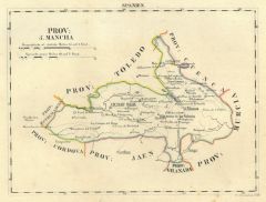
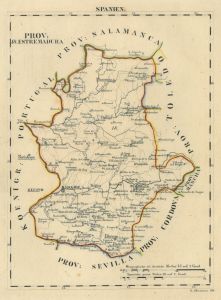
SPANIEN. - Karte. - Hispania. Gesamtkarte
Grenzkol. Stahlstich aus Meyer's Zeitungsatlas, 1853, 21 x 27 cm. (Artikelnr. 934BG)
Erfahren Sie mehr33,00 € Inkl. MwSt. -
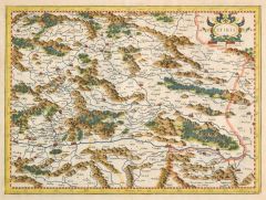
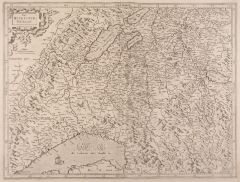
 STEIERMARK. - Karte. - Stiria. Steyermarck.
Kupferstich von Blaeu, um 1630, 38 x 49,5 cm.
Gesamtkarte mit Wappenkartusche. (Artikelnr. 4838CG)
Erfahren Sie mehr170,00 € Inkl. MwSt. -
24,00 € Inkl. MwSt.
-
DÄNEMARK. - Karte. - Dennmarck. Gesamtkarte.
Holzschnitt aus Seb. Münster, "Cosmographia", um 1590, 10 x 13,5 cm.
Auf der ganzen Buchseite. (Artikelnr. 33786EG)
Erfahren Sie mehr98,00 € Inkl. MwSt. -
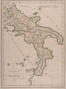
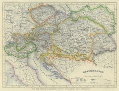 ÖSTERREICH. - Karte. - Oesterreich 1849. Gesamtkarte.
Grenzkol. Stahlstich aus Meyer's Zeitungsatlas, 1853, 19 x 26 cm. (Artikelnr. 541BG)
Erfahren Sie mehr38,00 € Inkl. MwSt. -
57,00 € Inkl. MwSt.
-
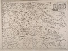
 STEIERMARK. - Karte. - Stiria.
Altkol. Kupferstich von G. Mercator, 1628, 31 x 41,5 cm.
Gesamtkarte mit altkolorierter Wappenkartusche rechts oben. - Verso mit Text. Sehr breitrandig. (Artikelnr. 27399CG)
Erfahren Sie mehr240,00 € Inkl. MwSt. -
 KORSIKA. - Karte. - Corscica. Gesamtkarte.
Altkol. Kupferstich von Mercator, um 1630, 34 x 23 cm (etwas gebräunt und fleckig). (Artikelnr. 2761GG)
Erfahren Sie mehr250,00 € Inkl. MwSt. -
66,00 € Inkl. MwSt.
-
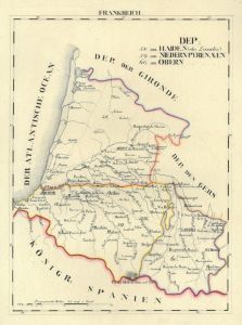
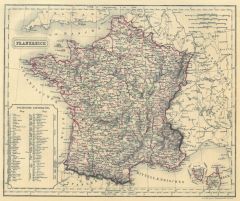 FRANKREICH. - Karte. - Frankreich. Gesamtkarte.
Grenzkol. Stahlstich von Biller aus Galletti bei Hartleben, 1840, 20 x 25 cm.
Espenhorst, PP 45.1.1. - Aus: J.G.A. Galletti's "Allgemeine Weltkunde" (9. Ausgabe 1840). - Fünf Karten "neu gestochen von F(ranz) Biller ... wunderschön von H... (Artikelnr. 19241BG)
Erfahren Sie mehr60,00 € Inkl. MwSt. -
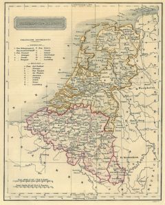 NIEDERLANDE. - Benelux. - Karte. - Niederland u. Belgien. Gesamtkarte.
Grenzkol. Stahlstich aus Galletti bei Hartleben, 1840, 25 x 20 cm.
Espenhorst, PP 45.1.1. - Aus: J.G.A. Galletti's "Allgemeine Weltkunde" (9. Ausgabe 1840). - Fünf Karten "neu gestochen von F(ranz) Biller ... wunderschön von Hand kolorie... (Artikelnr. 19240BG)
Erfahren Sie mehr60,00 € Inkl. MwSt. -
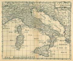
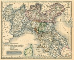 ITALIEN. - Norditalien. - Karte. - Nördliches Italien.
Grenzkol. Stahlstich aus Galletti bei Hartleben, 1840, 20 x 25 cm.
Espenhorst, PP 45.1.1. - Aus: J.G.A. Galletti's "Allgemeine Weltkunde" (9. Ausgabe 1840). - Fünf Karten "neu gestochen von F(ranz) Biller ... wunderschön von Hand kolorie... (Artikelnr. 19237BG)
Erfahren Sie mehr80,00 € Inkl. MwSt. -
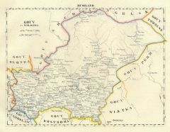
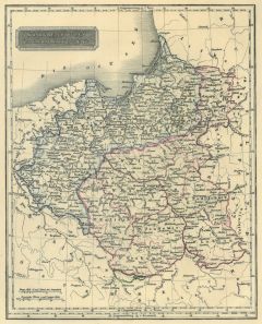 POLEN. - Karte. - Königreich Polen und die östl. Prov. Preussen's.
Grenzkol. Stahlstich aus Galletti bei Hartleben, 1840, 25 x 20 cm.
Espenhorst, PP 45.1.1. - Aus: J.G.A. Galletti's "Allgemeine Weltkunde" (9. Ausgabe 1840). - Fünf Karten "neu gestochen von F(ranz) Biller ... wunderschön von Hand kolorie... (Artikelnr. 12929CG)
Erfahren Sie mehr65,00 € Inkl. MwSt. -
 SCHWEIZ. - Karte. - Carte des Grisons et des Communautez.
Altkol. Kupferstich bei Chatelain, 1708, 35 x 47,5 cm.
Neun historische Karten der Schweizer Kantone, darunter Schrifttafeln zur Geschichte der Kantone St. Gallen, Neuchatel, Graubünden, Genf, Wallis und Bienne. - Mit breitem Rand und in ... (Artikelnr. 28184CG)
Erfahren Sie mehr380,00 € Inkl. MwSt. -
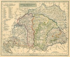 UNGARN. - Karte. - Ungarn, Siebenbürgen und Galizien.
Grenzkol. Stahlstich aus Galletti bei Hartleben, 1840, 20 x 25 cm.
Espenhorst, PP 45.1.1. - Aus: J.G.A. Galletti's "Allgemeine Weltkunde" (9. Ausgabe 1840). - Fünf Karten "neu gestochen von F(ranz) Biller ... wunderschön von Hand kolorie... (Artikelnr. 19245BG)
Erfahren Sie mehr70,00 € Inkl. MwSt. -
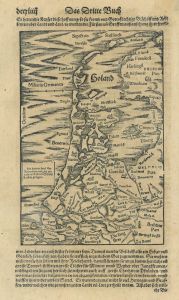 NIEDERLANDE. - Karte. - Holand.
Holzschnitt aus Seb. Münster, "Cosmographia", 1588, 20,5 x 14 cm.
Auf der vollen Buchseite der deutschen Ausgabe von 1588. - Nicht genordet. (Artikelnr. 14685CG)
Erfahren Sie mehr95,00 € Inkl. MwSt. -
IRLAND. - Karte. - Ireland.
Farblithographie aus Sohr-Berghaus bei Flemming, Glogau, um 1885, 40,5 x 33,5 cm.
Espenhorst, PP 4.1.3. - Aus: Sohr-Berghaus's "Hand-Atlas über alle Teile der Erde". (Artikelnr. 19477BG)
Erfahren Sie mehr80,00 € Inkl. MwSt. -
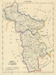
RUSSLAND. - Karte. - Russland.
Farblithographie aus Sohr-Berghaus bei Flemming, Glogau, um 1885, 40,5 x 33 cm.
Espenhorst, PP 4.1.3. - Aus: Sohr-Berghaus's "Hand-Atlas über alle Teile der Erde". (Artikelnr. 19484BG)
Erfahren Sie mehr80,00 € Inkl. MwSt. -
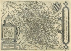 BURGUND. - Karte. - Burgundiae inferioris.
Kupferstich bei J. Bussemacher, 1592, 18 x 26 cm.
Gebietskarte mit 2 kleinen Kartuschen und Wappen. (Artikelnr. 5529CG)
Erfahren Sie mehr120,00 € Inkl. MwSt. -
GROSSBRITANNIEN. - Karte. - Isles Britanniques.
Altkol. Kupferstich von Lemercier bei Furne, Paris, um 1865, 42,5 x 34 cm.
Aus "Atlas de Géographie Militaire". (Artikelnr. 34781EG)
Erfahren Sie mehr90,00 € Inkl. MwSt. -
95,00 € Inkl. MwSt.
-
 STEIERMARK. - Karte. - Stiria. Steyermarck.
Altkol. Kupferstich von Blaeu, um 1630, 38 x 49,5 cm.
Gesamtkarte mit altkolorierter Wappenkartusche rechts oben. - Sehr breitrandig. (Artikelnr. 26380CG)
Erfahren Sie mehr280,00 € Inkl. MwSt. -
 GENFER SEE. - Karte. - Wiflispurgergou.
Kupferstich von Mercator, 1620, 36 x 48 cm.
Zeigt das Gebiet zwischen Bieler-, Thuner- und Genfer See.- Gering wasserrandig. (Artikelnr. 11231CG)
Erfahren Sie mehr280,00 € Inkl. MwSt. -
76,00 € Inkl. MwSt.
-
BELGIEN. - Karte. - Belgien.
Farblithographie aus Sohr-Berghaus bei Flemming, Glogau, um 1885, 33 x 40 cm.
Espenhorst, PP 4.1.3. - Aus: Sohr-Berghaus's "Hand-Atlas über alle Teile der Erde". (Artikelnr. 19480BG)
Erfahren Sie mehr70,00 € Inkl. MwSt. -
NIEDERLANDE. - Karte. - Niederlande.
Farblithographie aus Sohr-Berghaus bei Flemming, Glogau, um 1885, 40 x 32,5 cm.
Espenhorst, PP 4.1.3. - Aus: Sohr-Berghaus's "Hand-Atlas über alle Teile der Erde". (Artikelnr. 19479BG)
Erfahren Sie mehr70,00 € Inkl. MwSt. -
LIMOGES. - Karte. - Limaniae descriptio. Gesamtkarte.
Kupferstich bei Botero, um 1590, 8 x 11 cm (auf der vollen Buchseite). (Artikelnr. 16385CG)
Erfahren Sie mehr48,00 € Inkl. MwSt. -
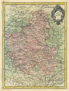 CHAMPAGNE. - Karte. - La Campagne.
Altkol. Kupferstich nach Brion de la Tour, um 1765, 27 x 20,5 cm.
Flächenkolorierte Gesamtkarte. Rechts oben kleine Titelkartusche. (Artikelnr. 16395CG)
Erfahren Sie mehr95,00 € Inkl. MwSt. -
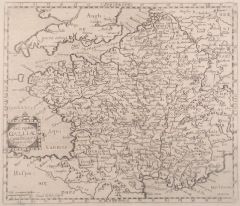 FRANKREICH. - Karte. - Descriptio Galliae.
Kupferstich aus Bellus, 1627, 26 x 30 cm.
Zeigt das Gebiet von Brest bis Zürich, von Leyden bis Marseille. (Artikelnr. 4654AG)
Erfahren Sie mehr114,00 € Inkl. MwSt. -
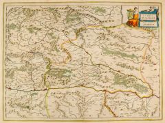
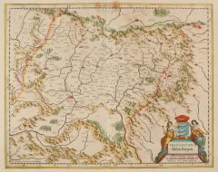 SIEBENBÜRGEN. - Karte. - Transylvania, Sibenburgen.
Altkol. Kupferstich von Janssonius nach Mercator, um 1630, 34,5 x 43,5 cm.
Mit schöner, figürlicher Kartusche. - Mit kleinen Braunflecken. (Artikelnr. 1226BG)
Erfahren Sie mehr240,00 € Inkl. MwSt. -
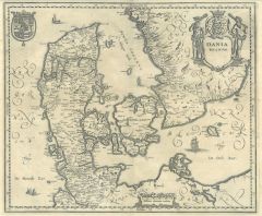 DÄNEMARK. - Karte. - Dania Regnum.
Kupferstich aus Gottfried, "Archontologia", 1649, 28,5 x 33,5 cm.
Gesamtkarte einschließlich Schleswig-Holstein, Rügen und Teil von Schweden. Mit Kartusche und Wappen. (Artikelnr. 6261AG)
Erfahren Sie mehr114,00 € Inkl. MwSt. -
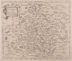 MÄHREN. - Karte. - Moravia Merhern.
Kupferstich aus Bellus, 1627, 26 x 30 cm.
Zeigt das Gebiet von Trebbin bis Meseritz und Freudental bis Mistelbach. (Artikelnr. 4651AG)
Erfahren Sie mehr120,00 € Inkl. MwSt.