Suchergebnisse für: "europa karte"
-
52,00 € Inkl. MwSt.
-
 IRLAND. - Karte. - Irland.
Farblithographie nach Scrobel aus Andree bei Velhagen & Klasing, 1893, 36 x 23 cm.
Espenhorst, PP 5.1.3. - Aus: Richard Andree's "Allgemeiner Handatlas" (3. Ausgabe, Auflage 1893). (Artikelnr. 34946EG)
Erfahren Sie mehr75,00 € Inkl. MwSt. -
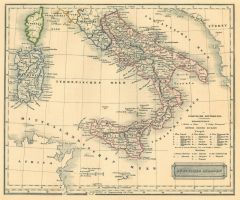
ITALIEN. - Karte. - Italie.
Altkol. Kupferstich von Lemercier bei Furne, Paris, um 1871, 42,5 x 34 cm.
Aus "Atlas de Géographie Militaire". - Italien nach der Einigung von 1870. (Artikelnr. 34783EG)
Erfahren Sie mehr90,00 € Inkl. MwSt. -
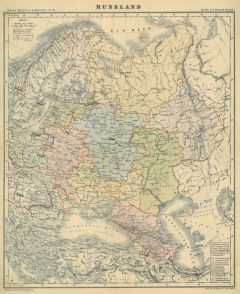 RUSSLAND. - Karte. - Russland.
Farblithographie aus Adami-Kiepert bei Reimer, 1876, 32,5 x 27,5 cm.
Espenhorst, PP Anm. 27, S. 778. - Aus: Adami-Kiepert's "Schul-Atlas" (Ausgabe 1876). - Mit alten Tusche Unterstreichungen. (Artikelnr. 19426BG)
Erfahren Sie mehr60,00 € Inkl. MwSt. -
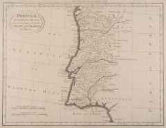 PORTUGAL. - Karte. - Portugal.
Kupferstich nach Bowen aus Barlow, 1789, 30 x 39 cm.
Zeigt das Gebiet zwischen Lissabon im Westen und Alcantara im Osten, im Norden Vigo, im Süden Cadiz. (Artikelnr. 13231AG)
Erfahren Sie mehr86,00 € Inkl. MwSt. -
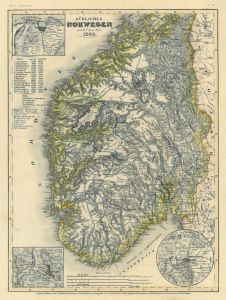 NORWEGEN. - Karte. - Südliches Norwegen.
Grenzkol. Stahlstich aus Meyer's Zeitungsatlas, 1853, 24,5 x 18,5 cm.
Reicht im Norden bis Trondheim. Mit drei Umgebungskarten von Bergen, Trondheim und Oslo. (Artikelnr. 17263AG)
Erfahren Sie mehr57,00 € Inkl. MwSt. -
 BÖHMEN. - Karte. - Regni Bohemiae.
Altkol. Kupferstich von Johann Baptist Homann, um 1720, 47 x 56 cm.
Flächenkolorierte Gesamtkarte des Königreichs. Mit großer figürlicher Kartusche rechts oben. (Artikelnr. 27407CG)
Erfahren Sie mehr220,00 € Inkl. MwSt. -
FLANDERN. - Karte. - Die Graffschafft Flandern.
Altkol. Kupferstich bei Schreiber, um 1730, 16,5 x 24 cm.
Mit kleiner Kartusche und Legende. (Artikelnr. 5954AG)
Erfahren Sie mehr62,00 € Inkl. MwSt. -
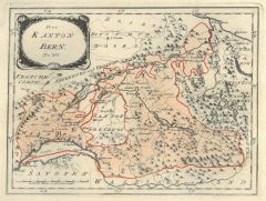
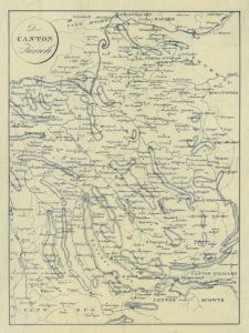 ZÜRICH. - Karte. - Der Canton Zürich.
Kupferstich, um 1830, 25,5 x 19 cm.
Kantonskarte von Schaffhausen bis zum Zürichsee und Bremgarten bis Fischental. (Artikelnr. 10145AG)
Erfahren Sie mehr130,00 € Inkl. MwSt. -
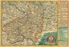 LEITMERITZ. - Karte. - Der Leutmeritzer Creys.
Altkol. Kupferstich bei Schreiber, um 1730, 16 x 23 cm.
Mit hübscher kleiner Kartusche und Legende. (Artikelnr. 5975AG)
Erfahren Sie mehr81,00 € Inkl. MwSt. -
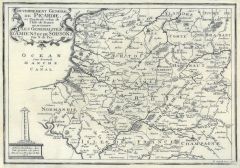
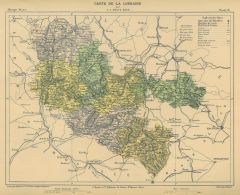 LOTHRINGEN. - Karte. - Carte de la Lorraine.
Farblithographie von Erhard aus Malte-Brun, um 1880, 24 x 31 cm. (Artikelnr. 194AG)
Erfahren Sie mehr38,00 € Inkl. MwSt. -
SCHOTTLAND. - Karte. - Schottland.
Farblithographie aus Sohr-Berghaus bei Flemming, Glogau, um 1885, 40 x 33 cm.
Espenhorst, PP 4.1.3. - Aus: Sohr-Berghaus's "Hand-Atlas über alle Teile der Erde". - Mit einer Nebenkarte der Shetlandinseln. (Artikelnr. 19476BG)
Erfahren Sie mehr70,00 € Inkl. MwSt. -
ITALIEN. - Karte. - Italie.
Altkol. Kupferstich von Lemercier bei Furne, Paris, um 1865, 42,5 x 34 cm.
Aus "Atlas de Géographie Militaire". - Die Italienischen Staaten vor der Einigung von 1860 bzw. 1870. (Artikelnr. 34782EG)
Erfahren Sie mehr90,00 € Inkl. MwSt. -
BELGIEN. - Karte. - Die Oesterreichische Niederlande.
Altkol. Kupferstich bei Schreiber, um 1730, 16 x 24 cm.
Gesamtkarte mit kleiner Kartusche und Legende. (Artikelnr. 5951AG)
Erfahren Sie mehr57,00 € Inkl. MwSt. -
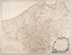 FLANDERN. - Karte. - Comté de Flandre.
Grenzkol. Kupferstich von Robert de Vaugondy, 1752, 48 x 62 cm.
Gesamtkarte mit Kartusche und Meilenzeiger. (Artikelnr. 4862CG)
Erfahren Sie mehr114,00 € Inkl. MwSt. -
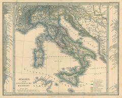
ITALIEN. - Karte. - Italien. Gesamtkarte.
Farblithographie aus Sohr-Berghaus bei Flemming, Glogau, um 1885, 40,5 x 33 cm.
Espenhorst, PP 4.1.3. - Aus: Sohr-Berghaus's "Hand-Atlas über alle Teile der Erde". (Artikelnr. 19469BG)
Erfahren Sie mehr85,00 € Inkl. MwSt. -
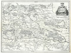 STEIERMARK. - Karte. - Stiria Steyermarckt.
Kupferstich von Merian, 1649, 27 x 36 cm.
Gesamtkarte zwischen St. Lambrecht, im Süden die Draun, Hartberg und Afflenz, Graz im Mittelpunkt (rechts angerändert). (Artikelnr. 17207AG)
Erfahren Sie mehr114,00 € Inkl. MwSt. -
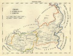 BRABANT. - Karte. - Prov: Südbrabant und Limburg.
Grenzkol. Lithographie von O. Hermann bei Schlieben, 1829, 19 x 26 cm. (Artikelnr. 18706AG)
Erfahren Sie mehr75,00 € Inkl. MwSt. -
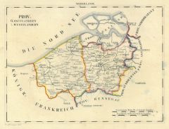 FLANDERN. - Karte. - Prov: Ostflandern und Westflandern.
Grenzkol. Lithographie von O. Hermann bei Schlieben, 1829, 19 x 26 cm. (Artikelnr. 18709AG)
Erfahren Sie mehr60,00 € Inkl. MwSt. -
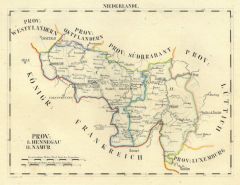 HENNEGAU. - Karte. - Prov: Hennegau und Namur.
Grenzkol. Lithographie von O. Hermann bei Schlieben, 1829, 19 x 26 cm. (Artikelnr. 18704AG)
Erfahren Sie mehr62,00 € Inkl. MwSt. -
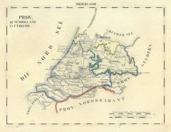 UTRECHT. - Karte. - Prov: Südholland und Utrecht.
Grenzkol. Lithographie von O. Hermann bei Schlieben, 1829, 19 x 26 cm. (Artikelnr. 18707AG)
Erfahren Sie mehr68,00 € Inkl. MwSt. -
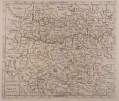 ÖSTERREICH. - Karte. - Austria Archi Ducatus.
Kupferstich aus Bellus, 1627, 26 x 30 cm.
Zeigt die Donau von Passau bis Hainburg, von Znaim bis Graz. (Artikelnr. 4652AG)
Erfahren Sie mehr142,00 € Inkl. MwSt. -
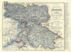 KÄRNTEN. - Karte. - Herzogthum Kaernthen und Krain 1852.
Grenzkol. Stahlstich aus Meyer's Zeitungsatlas, 1853, 19 x 27 cm. (Artikelnr. 12923CG)
Erfahren Sie mehr48,00 € Inkl. MwSt. -
57,00 € Inkl. MwSt.
-
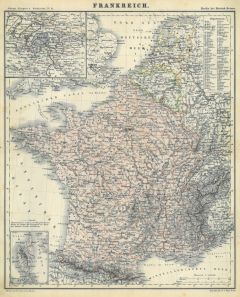 FRANKREICH. - Karte. - Frankreich.
Farblithographie aus Adami-Kiepert bei Reimer, 1876, 32,5 x 27 cm.
Espenhorst, PP Anm. 27, S. 778. - Aus: Adami-Kiepert's "Schul-Atlas" (Ausgabe 1876). - Mit zwei Nebenkarten von Paris und Koriska. (Artikelnr. 19423BG)
Erfahren Sie mehr50,00 € Inkl. MwSt. -
114,00 € Inkl. MwSt.
-
57,00 € Inkl. MwSt.
-
70,00 € Inkl. MwSt.
-
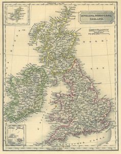 GROSSBRITANNIEN. - Karte. - England, Schotland, Ireland. Gesamtkarte, mit zwei kleinen Nebenkarten.
Grenzkol. Stahlstich aus Galletti bei Hartleben, 1840, 25 x 20 cm.
Espenhorst, PP 45.1.1. - Aus: J.G.A. Galletti's "Allgemeine Weltkunde" (9. Ausgabe 1840). - Fünf Karten "neu gestochen von F(ranz) Biller ... wunderschön von Hand kolorie... (Artikelnr. 19243BG)
Erfahren Sie mehr70,00 € Inkl. MwSt. -
 ITALIEN. - Süditalien. - Karte. - Südliches Italien.
Grenzkol. Stahlstich aus Galletti bei Hartleben, 1840, 20 x 25 cm.
Espenhorst, PP 45.1.1. - Aus: J.G.A. Galletti's "Allgemeine Weltkunde" (9. Ausgabe 1840). - Fünf Karten "neu gestochen von F(ranz) Biller ... wunderschön von Hand kolorie... (Artikelnr. 19238BG)
Erfahren Sie mehr75,00 € Inkl. MwSt. -
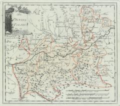
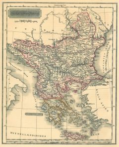 BALKAN. - Karte. - Europaeische Türkey. Zeigt die gesamte Balkanhalbinsel, mit Kreta.
Grenzkol. Stahlstich aus Galletti bei Hartleben, 1840, 25 x 20 cm.
Espenhorst, PP 45.1.1. - Aus: J.G.A. Galletti's "Allgemeine Weltkunde" (9. Ausgabe 1840). - Fünf Karten "neu gestochen von F(ranz) Biller ... wunderschön von Hand kolorie... (Artikelnr. 19235BG)
Erfahren Sie mehr75,00 € Inkl. MwSt. -
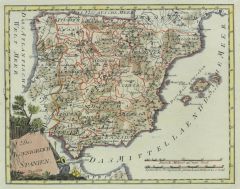
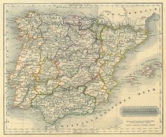 SPANIEN und PORTUGAL. - Karte. - Spanien und Portugal. Gesamtkarte mit den Balearen.
Grenzkol. Stahlstich aus Galletti bei Hartleben, 1840, 20 x 25 cm.
Espenhorst, PP 45.1.1. - Aus: J.G.A. Galletti's "Allgemeine Weltkunde" (9. Ausgabe 1840). - Fünf Karten "neu gestochen von F(ranz) Biller ... wunderschön von Hand kolorie... (Artikelnr. 19242BG)
Erfahren Sie mehr75,00 € Inkl. MwSt. -
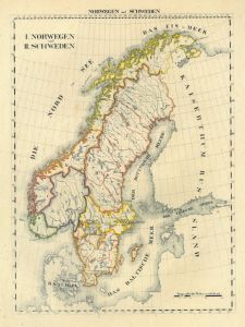
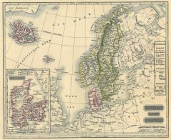 SKANDINAVIEN. - Karte. - Schweden und Norwegen.
Grenzkol. Stahlstich aus Galletti bei Hartleben, 1840, 20 x 25 cm.
Espenhorst, PP 45.1.1. - Aus: J.G.A. Galletti's "Allgemeine Weltkunde" (9. Ausgabe 1840). - Fünf Karten "neu gestochen von F(ranz) Biller ... wunderschön von Hand kolorie... (Artikelnr. 19236BG)
Erfahren Sie mehr75,00 € Inkl. MwSt. -
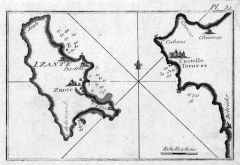
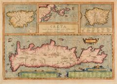 KRETA. - Karte. - Creta Iouis magni, medio iacet insula ponto.
Altkol. Kupferstich von Abraham Ortelius, um 1620 34 x 49 cm.
Van den Broecke 217. - Gesamtkarte der Insel Kreta (19 x 47 cm), darüber Karten von Korsika, den Ionischen Inseln und Sardinien. - Insgesamt gebräunt, verso umlaufend Papierst... (Artikelnr. 2760GG)
Erfahren Sie mehr400,00 € Inkl. MwSt. -
 BURGUND. - Karte. - Vtrivsque Bvrvndiae.
Kupferstich aus Gottfried, "Archontologia", 1649, 27 x 35 cm.
Gebietskarte zwischen Verzelet und Clermont sowie zwischen Tornus und Longres. Mit Titelkartusche und zwei Wappen. (Artikelnr. 6757AG)
Erfahren Sie mehr110,00 € Inkl. MwSt.