Suchergebnisse für: "europa karte"
-
 HENNEGAU. - Karte. - Comitatus Hannoniaes.
Altkol. Kupferstich von J.B. Homann, um 1720, 48,5 x 57,5 cm.
Gebietskarte mit den Städten als Befestigungsgrundriß, links oben Kartusche mit Wappen und Putti. (Artikelnr. 16019CG)
Erfahren Sie mehr133,00 € Inkl. MwSt. -
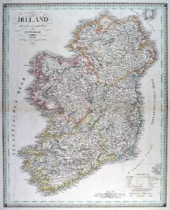
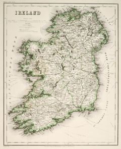 IRLAND. - Karte. - Ireland. Gesamtkarte.
Grenzkol. Stahlstich aus Meyer bei BI, um 1865, 37 x 30 cm.
Espenhorst, PP 3.4 (Meyer-Ravenstein 1862-1884). - Aus: Joseph Meyer's "Hand-Atlas", redigiert von Ludwig Ravenstein (1838-1915). (Artikelnr. 19303BG)
Erfahren Sie mehr140,00 € Inkl. MwSt. -
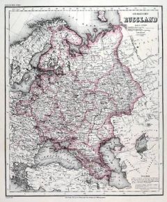 RUSSLAND. - Karte. - Europaeisches Russland.
Grenzkol. Stahlstich aus Meyer bei BI, um 1865, 36 x 30 cm.
Espenhorst, PP 3.4 (Meyer-Ravenstein 1862-1884). - Aus: Joseph Meyer's "Hand-Atlas", redigiert von Ludwig Ravenstein (1838-1915). (Artikelnr. 19266BG)
Erfahren Sie mehr120,00 € Inkl. MwSt. -
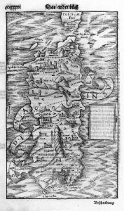 SARDINIEN. - Karte. - Sardinia. Gesamtkarte, mit Schriftband.
Holzschnitt aus Seb. Münster, "Cosmographia", um 1590, 25,5 x 15,5 cm.
Auf der ganzen Buchseite. (Artikelnr. 33789EG)
Erfahren Sie mehr140,00 € Inkl. MwSt. -
GRIECHENLAND. - Karte. - La Turquie d'Europe.
Grenzkol. Kupferstich nach Hérisson, 1806, 18 x 22 cm.
Griechenland und der Balkan mit Kroatien, Bosnien, Serbien, der Walachei und Moldawien. (Artikelnr. 19178CG)
Erfahren Sie mehr76,00 € Inkl. MwSt. -
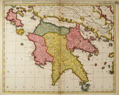 GRIECHENLAND. - Peloponnes. - Karte. - Regnum Moreae.
Altkol. Kupferstich von G. u. L. Valck, um 1710, 49 x 59 cm.
Gesamtkarte der Halbinsel. Mit Kopftitel. Bugfalte leicht gebräunt. (Artikelnr. 10196CG)
Erfahren Sie mehr280,00 € Inkl. MwSt. -
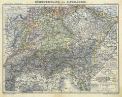 ÖSTERREICH. - Karte. - Süddeutschland und Alpenländer.
Farblithographie aus Adami-Kiepert bei Reimer, 1876, 24,5 x 32 cm.
Espenhorst, PP Anm. 27, S. 778. - Aus: Adami-Kiepert's "Schul-Atlas" (Ausgabe 1876). (Artikelnr. 19437BG)
Erfahren Sie mehr60,00 € Inkl. MwSt. -
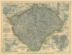 BÖHMEN. - Karte. - Königreich Böhmen 1849.
Grenzkol. Stahlstich aus Meyer's Zeitungsatlas, 1853, 18,5 x 25 cm.
Gesamtkarte mit vier kleinen Vignetten von Prag, Teplitz, Karlsbad und Marienbad. (Artikelnr. 1206AG)
Erfahren Sie mehr60,00 € Inkl. MwSt. -
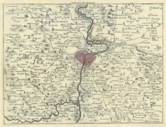 PRAG. - Karte. - Environs de Prague
Altkol. Kupferstich bei Le Rouge aus "Atlas Portatif", 1759, 21 x 27,5 cm.
Stadtgrundriss von Prag mit der näheren Umgebung. (Artikelnr. 26100CG)
Erfahren Sie mehr120,00 € Inkl. MwSt. -
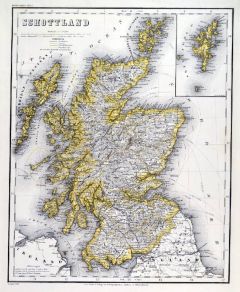 SCHOTTLAND. - Karte. - Schottland.
Grenzkol. Stahlstich aus Meyer bei BI, um 1865, 36,5 x 29,5 cm.
Espenhorst, PP 3.4 (Meyer-Ravenstein 1862-1884). - Aus: Joseph Meyer's "Hand-Atlas", redigiert von Ludwig Ravenstein (1838-1915). - Mit einer Nebenkarte der Shetlandinseln. (Artikelnr. 19256BG)
Erfahren Sie mehr100,00 € Inkl. MwSt. -
57,00 € Inkl. MwSt.
-
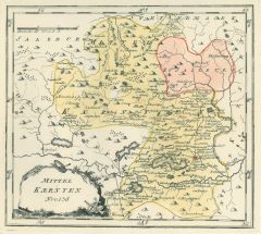 KÄRNTEN. - Karte. - Mittel Kaernten Nro. 138.
Grenzkol. Kupferstich von Reilly, um 1790, 22 x 26 cm.
Seitlich aufgeklebtes Exlibris-Wappen von "Freiherr von Malsen-Ponickau". (Artikelnr. 6477AG)
Erfahren Sie mehr110,00 € Inkl. MwSt. -
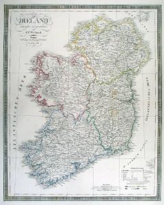
 IRLAND. - Karte. - Ireland. Gesamtkarte.
Grenzkol. Kupferstich nach Weiland, Weimar im Geograph. Institut, dat. 1827, 60 x 48,5 cm.
Espenhorst, PP 1.1.2. - Mit Farberklärungen für die Provinzen Leinster, Ulster, Connaught und Munster. (Artikelnr. 33072EG)
Erfahren Sie mehr108,00 € Inkl. MwSt. -
 IRLAND. - Karte. - Ireland. Gesamtkarte.
Grenzkol. Kupferstich nach Weiland, Weimar im Geograph. Institut, dat. 1857, 61 x 49,5 cm.
Espenhorst, PP 1.1.5. - Mit Farberklärungen für die Provinzen Leinster, Ulster, Connaught und Munster. (Artikelnr. 33158EG)
Erfahren Sie mehr158,00 € Inkl. MwSt. -
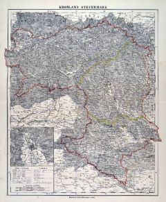 STEIERMARK. - Karte. - Kronland Steyermark.
Farblithographie aus Sohr-Berghaus bei Flemming, Glogau, um 1885, 40,5 x 33 cm.
Espenhorst, PP 4.1.3. - Aus: Sohr-Berghaus's "Hand-Atlas über alle Teile der Erde". - Mit einer Nebenkarte. (Artikelnr. 19462BG)
Erfahren Sie mehr80,00 € Inkl. MwSt. -
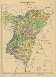 ELSASS. - Karte. - Carte de la Basse Alsace.
Farblithographie von Erhard aus Malte-Brun, um 1880, 31 x 24 cm. (Artikelnr. 180AG)
Erfahren Sie mehr38,00 € Inkl. MwSt. -
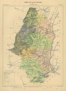 ELSASS. - Karte. - Carte de la Haute Alsace.
Farblithographie von Erhard aus Malte-Brun, um 1880, 31 x 23,5 cm. (Artikelnr. 11822CG)
Erfahren Sie mehr38,00 € Inkl. MwSt. -
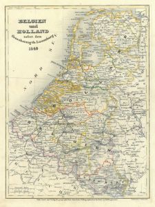 BELGIEN. - Holland. - Karte. - Belgien und Holland 1849.
Grenzkol.Stahlstich von Metzeroth aus Meyer's Zeitungsatlas, 1853, 24 x 18 cm. (Artikelnr. 17267AG)
Erfahren Sie mehr57,00 € Inkl. MwSt. -
PROVENCE. - Karte. - Comté, et Gouvernement de Provence.
Kupferstich von Merian aus "Theatrum Europaeum", 1657, 25 x 36 cm. (Artikelnr. 19709CG)
Erfahren Sie mehr95,00 € Inkl. MwSt. -
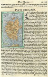
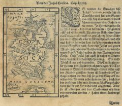 KORSIKA. - Karte. - Von der Insel Corsica. Gesamtkarte.
Holzschnitt aus Seb. Münster, "Cosmographia", um 1580, 12,5 x 8 cm. (Artikelnr. 8388CG)
Erfahren Sie mehr50,00 € Inkl. MwSt. -
BALKAN. - Karte. - Die Balkan-Halbinsel.
Farblithographie aus Sohr-Berghaus bei Flemming, Glogau, um 1885, 40,5 x 33 cm.
Espenhorst, PP 4.1.3. - Aus: Sohr-Berghaus's "Hand-Atlas über alle Teile der Erde". (Artikelnr. 19485BG)
Erfahren Sie mehr80,00 € Inkl. MwSt. -
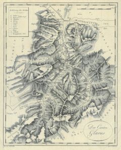 GLARUS. - Karte. - Der Canton Glarus.
Kupferstich von Scheurman nach Keller, um 1840, 26,5 x 21 cm.
Schöne Kantonskarte von Reichenburg und Wallenstätter See bis Dödiberg, Segnes- Pass und Falzhabern. (Artikelnr. 10140AG)
Erfahren Sie mehr114,00 € Inkl. MwSt. -
SKANDINAVIEN. - Karte. - Gotland oder Gothen.
Holzschnitt aus Seb. Münster, "Cosmographia", um 1590, 10 x 13,5 cm.
Zeigt Norwegen, Schweden, Finnland, Livland, Reval und Riga. - Auf der ganzen Buchseite. (Artikelnr. 33791EG)
Erfahren Sie mehr88,00 € Inkl. MwSt. -
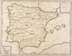 SPANIEN. - Karte. - L'Espagne Selon les Anciens.
Kupferstich bei J.-R. Joly, 1801, 30,5 x 39 cm.
Gesamtkarte mit kleiner Nebenkarte von Cadiz. - Faltspuren. (Artikelnr. 14781BG)
Erfahren Sie mehr114,00 € Inkl. MwSt. -
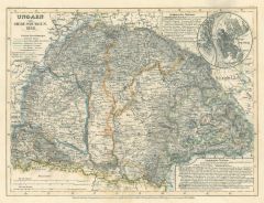 UNGARN. - Karte. - Ungarn und Siebenbürgen 1849.
Grenzkol. Stahlstich aus Meyer's Zeitungsatlas, 1853, 18,5 x 24 cm.
Gesamtkarte, rechts kleine Vignette mit Plan von Budapest. (Artikelnr. 17261AG)
Erfahren Sie mehr45,00 € Inkl. MwSt. -
UNGARN. - Karte. - Ungarn und Siebenbürgen 1858.
Grenzkol. Stahlstich aus BI, um 1860, 14 x 9 cm.
Gesamtkarte, rechts kleine Vignette mit Plan von Budapest. (Artikelnr. 17303AG)
Erfahren Sie mehr19,00 € Inkl. MwSt. -
 KORSIKA. - Karte. - Von der inseln Corsica. Gesamtkarte.
Kol. Holzschnitt aus Seb. Münster, "Cosmographia", um 1580, 12,5 x 8 cm. (Artikelnr. 36116EG)
Erfahren Sie mehr80,00 € Inkl. MwSt. -
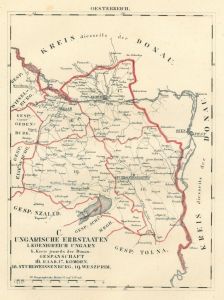 STUHLWEISSENBURG. - Karte. - Gespanschaft, Raab, Komorn, Stuhlweissenburg, Weszprim.
Grenzkol. Lithographie bei Schlieben, 1829, 26 x 19 cm.
Gebietskarte zwischen Raab und Plattensee. (Artikelnr. 18749AG)
Erfahren Sie mehr60,00 € Inkl. MwSt. -
SCHWEIZ. - Karte. - Die Schweiz.
Farblithographie aus Sohr-Berghaus bei Flemming, Glogau, um 1885, 33 x 40,5 cm.
Espenhorst, PP 4.1.3. - Aus: Sohr-Berghaus's "Hand-Atlas über alle Teile der Erde". - Mit einer Nebenkarte vom Vierwaldstättersee. (Artikelnr. 19468BG)
Erfahren Sie mehr70,00 € Inkl. MwSt. -
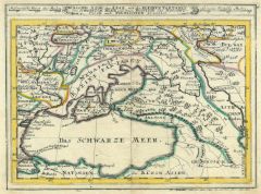
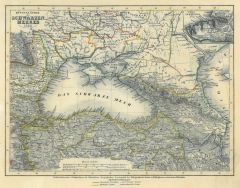 SCHWARZES MEER. - Karte. - Küstenländer des Schwarzen Meeres 1850.
Grenzkol. Stahlstich aus Meyer's Zeitungsatlas, 1853, 18 x 24 cm. (Artikelnr. 695AG)
Erfahren Sie mehr38,00 € Inkl. MwSt. -
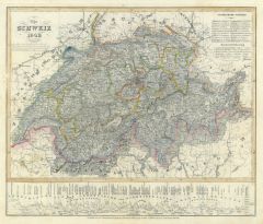 SCHWEIZ. - Karte. - Die Schweiz 1849. Gesamtkarte, unten Höhenprofile.
Grenzkol. Stahlstich aus Meyer's Zeitungsatlas, 1853, 21,5 x 25 cm. (Artikelnr. 974AG)
Erfahren Sie mehr45,00 € Inkl. MwSt. -
 NIEDERLANDE. - Karte. - Hollande.
Kupferstich von Dyonnet nach Duvotenay aus Lavallée bei Furne, Paris, 1858, 20,5 x 26 cm.
Aus: Théophile Lavallée's "Atlas de Géographie Militaire". - Zeigt das Gebiet von Brügge bzw. Düsseldorf im Süden bis Emden im Norden. (Artikelnr. 34856EG)
Erfahren Sie mehr55,00 € Inkl. MwSt. -
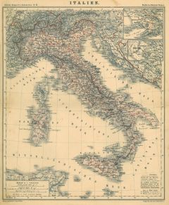 ITALIEN. - Karte. - Italien.
Farblithographie aus Adami-Kiepert bei Reimer, 1876, 32,5 x 27,5 cm.
Espenhorst, PP Anm. 27, S. 778. - Aus: Adami-Kiepert's "Schul-Atlas" (Ausgabe 1876). - Mit zwei kleinen Nebenkarten von Neapel und Rom. - Mit alten Tusche Einzeichnungen. (Artikelnr. 19421BG)
Erfahren Sie mehr55,00 € Inkl. MwSt. -
 POLEN. - Karte. - Poland.
Holzschnitt aus Seb. Münster, "Cosmographia", um 1590, 8 x 13,5 cm.
Nicht genordet. Zeigt folgendes Gebiet: links Danzig, Thorn und Oder, unten Przemysl, Lemberg und der Bug, oben Ostpreußen und Lithauen, rechts "Kyouia". - Auf der ganze... (Artikelnr. 33783EG)
Erfahren Sie mehr98,00 € Inkl. MwSt. -
SCHWEIZ. - Karte. - Suisse.
Kupferstich von Dyonnet nach Duvotenay aus Lavallée bei Furne, Paris, 1858, 20,5 x 26,5 cm.
Aus: Théophile Lavallée's "Atlas de Géographie Militaire". - Zeigt im Norden den Bodensee, im Süden den St. Bernhardino, im Westen Laupen, im ... (Artikelnr. 34863EG)
Erfahren Sie mehr55,00 € Inkl. MwSt. -
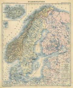 SKANDINAVIEN. - Karte. - Scandinavien.
Farblithographie aus Adami-Kiepert bei Reimer, 1876, 31,5 x 26 cm.
Espenhorst, PP Anm. 27, S. 778. - Aus: Adami-Kiepert's "Schul-Atlas" (Ausgabe 1876). - Mit zwei Nebenkarten von Island und den Färöer Inseln. - Mit alten Tusche Unterstre... (Artikelnr. 19425BG)
Erfahren Sie mehr55,00 € Inkl. MwSt. -
ITALIEN. - Norditalien. - Karte. - Nördliches Italien.
Farblithographie aus Sohr-Berghaus bei Flemming, Glogau, um 1885, 33 x 40,5 cm.
Espenhorst, PP 4.1.3. - Aus: Sohr-Berghaus's "Hand-Atlas über alle Teile der Erde". (Artikelnr. 19470BG)
Erfahren Sie mehr85,00 € Inkl. MwSt. -
 BÖHMEN. - Karte. - Das Königreich Böhmen.
Grenzkol. Kupferstich von Metzeroth nach Weiland, Weimar im Geograph. Institut, dat. 1829, 46,5 x 58 cm.
Espenhorst, PP 1.1.2. - Im Unterrand etwas fleckig. (Artikelnr. 33030EG)
Erfahren Sie mehr110,00 € Inkl. MwSt. -
SKANDINAVIEN. - Karte. - Das Koenigreich Schweden und Norwegen.
Altkol. Kupferstich bei Schreiber, um 1730, 16 x 24 cm.
Mit Kartusche (Löwe) und Legende. (Artikelnr. 5970AG)
Erfahren Sie mehr57,00 € Inkl. MwSt. -
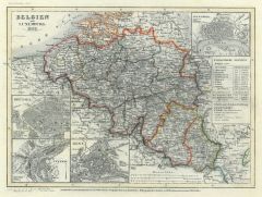 BELGIEN. - Karte. - Belgien und Luxemburg 1849.
Grenzkol. Stahlstich aus Meyer's Zeitungsatlas, 1853, 18 x 25 cm.
Mit 4 Plänen von Brüssel, Lüttich, Gent und Antwerpen. (Artikelnr. 13BG)
Erfahren Sie mehr52,00 € Inkl. MwSt. -
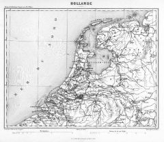
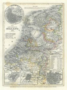 NIEDERLANDE. - Karte. - Das Königreich Holland 1849.
Grenzkol. Stahlstich aus Meyer's Zeitungsatlas, 1853, 25 x 18 cm.
Mit vier Plänen von Amsterdam, Breda, Haarlem und Leyden. (Artikelnr. 106BG)
Erfahren Sie mehr48,00 € Inkl. MwSt. -
GROSSBRITANNIEN. - Karte. - Beschreibung Engellandes und Schottlandtes.
Holzschnitt aus Seb. Münster, "Cosmographia", 1588, 25 x 17 cm.
Gesamtkarte auf der vollen Buchseite der deutschen Ausgabe von 1588. (Artikelnr. 14688CG)
Erfahren Sie mehr140,00 € Inkl. MwSt. -
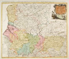 PICARDIE. - Karte. - Gouvernement General de Picardie.
Altkol. Kupferstich bei Homann Erben, um 1750, 47 x 56 cm.
Gebietskarte mit großer Titelkartusche rechts oben und Kopftitel. (Artikelnr. 28483CG)
Erfahren Sie mehr180,00 € Inkl. MwSt.