Suchergebnisse für: "europa karte"
-
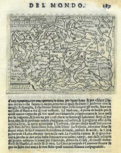
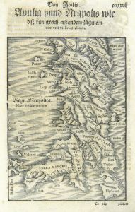 ITALIEN. - Süditalien. - Karte. - Apulia und Neapolis.
Holzschnitt aus Seb. Münster, "Cosmographia", um 1590, 20,5 x 15 cm.
Zeigt Süditalien ab Terracina. - Auf der ganzen Buchseite. (Artikelnr. 33788EG)
Erfahren Sie mehr108,00 € Inkl. MwSt. -
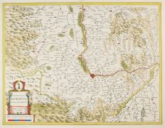 BASEL. - Karte. - Territory Basiliensis Nova Descriptio.
Altkol. Kupferstich von J. Janssonius bei P. Kaerius, 1647, 38 x 49 cm.
Breitrandige, wohl erhaltene Gebietskarte mit schöner Kartusche. (Artikelnr. 28361CG)
Erfahren Sie mehr320,00 € Inkl. MwSt. -
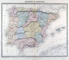 SPANIEN und PORTUGAL. - Karte. - Espagne & Portugal.
Altkol. Kupferstich von Lemercier bei Furne, Paris, um 1865, 34 x 42,5 cm.
Aus "Atlas de Géographie Militaire". (Artikelnr. 34784EG)
Erfahren Sie mehr95,00 € Inkl. MwSt. -
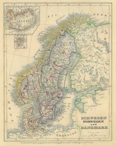 SKANDINAVIEN. - Karte. - Schweden Norwegen und Dänemark.
Grenzkol. Stahlstich aus Meyer's Zeitungsatlas, 1853, 23 x 18 cm.
Mit kleinen Plänen von Island und den Faröer Inseln links oben. (Artikelnr. 17264AG)
Erfahren Sie mehr43,00 € Inkl. MwSt. -
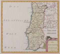
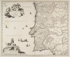 PORTUGAL. - Karte. - Portugalliae et Algarbiae regna.
Kupferstich von Nicolas Visscher, um 1690, 46 x 56 cm.
Gesamtkarte mit zwei großen, figürlichen Kartuschen links oben und unten. (Artikelnr. 2677GG)
Erfahren Sie mehr250,00 € Inkl. MwSt. -
GROSSBRITANNIEN. - England. - Karte. - Royme d'Angleterre. Gesamtkarte von England.
Grenzkol. Kupferstich von Robert de Vaugondy, 1748, 16 x 16 cm. (Artikelnr. 18814AG)
Erfahren Sie mehr76,00 € Inkl. MwSt. -
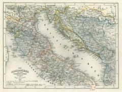 ADRIA. - Karte. - Das Adriameer mit seinen Unterstaaten 1852.
Grenzkol. Stahlstich aus Meyer's Zeitungsatlas, 1853, 18 x 24 cm. (Artikelnr. 246CG)
Erfahren Sie mehr45,00 € Inkl. MwSt. -
57,00 € Inkl. MwSt.
-
66,00 € Inkl. MwSt.
-
48,00 € Inkl. MwSt.
-
57,00 € Inkl. MwSt.
-
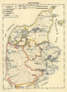 JÜTLAND. - Karte. - Stift Aalborg, Wiborg, Aarhuus, Ribe. Gesamtkarte
Grenzkol. Lithographie von Hermann bei Schlieben, 1829, 26 x 19 cm. (Artikelnr. 18748AG)
Erfahren Sie mehr66,00 € Inkl. MwSt. -
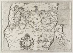
 NEAPEL. - Karte. - Neapolitanum Regnum.
Kupferstich von Hondius, um 1625, 43 x 52 cm.
Zeigt das Königreich Neapel zwischen Rom und der Nordspitze von Sizilien. Rechts unten Titelkartusche mit Wappen und allegorischen Figuren. Verso mit deutschem Text. (Artikelnr. 16458CG)
Erfahren Sie mehr350,00 € Inkl. MwSt. -
RUSSLAND. - Karte. - Russland. Gesamtkarte.
Grenzkol. Kupferstich von Reyher und Seitz aus Kiepert bei Reimer, Berlin, 1858, 54,5 x 44 cm.
Espenhorst, PP 20.1.1. - Aus: Heinrich Kiepert's "Neuer Handatlas über alle Theile der Erde" (Ausgabe 1858). (Artikelnr. 19016BG)
Erfahren Sie mehr90,00 € Inkl. MwSt. -
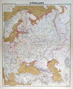 RUSSLAND. - Karte. - Russland. Gesamtkarte.
Grenzkol. Kupferstich von Reyher und Seitz aus Kiepert bei Reimer, Berlin, 1861, 54,5 x 44 cm.
Espenhorst, PP 20.1.1. - Aus: Heinrich Kiepert's "Neuer Handatlas über alle Theile der Erde" (Ausgabe 1861). (Artikelnr. 19145BG)
Erfahren Sie mehr90,00 € Inkl. MwSt. -
RUSSLAND. - Karte. - Russland. Gesamtkarte.
Grenzkol. Lithographie von Sulzer aus Kiepert bei Reimer, Berlin, 1875, 54,5 x 44 cm.
Espenhorst, PP 20.1.2. - Aus: Heinrich Kiepert's "Neuer Handatlas über alle Theile der Erde" (Ausgabe 1875). - Berichtigt 1874. (Artikelnr. 19020BG)
Erfahren Sie mehr90,00 € Inkl. MwSt. -
RUSSLAND. - Karte. - Russland. Gesamtkarte.
Grenzkol. Lithographie von Sulzer aus Kiepert bei Reimer, Berlin, 1871, 54,5 x 44 cm.
Espenhorst, PP 20.1.2. - Aus: Heinrich Kiepert's "Neuer Handatlas über alle Theile der Erde" (Ausgabe 1871). - Berichtigt 1870. (Artikelnr. 19103BG)
Erfahren Sie mehr90,00 € Inkl. MwSt. -
SCHWEIZ. - Karte. - Schweiz. Gesamtkarte.
Grenzkol. Kupferstich von Brose und Jaeck aus Kiepert bei Reimer, Berlin, 1861, 44,5 x 56 cm.
Espenhorst, PP 20.1.1. - Aus: Heinrich Kiepert's "Neuer Handatlas über alle Theile der Erde" (Ausgabe 1861). (Artikelnr. 19137BG)
Erfahren Sie mehr70,00 € Inkl. MwSt. -
SCHWEIZ. - Karte. - Schweiz. Gesamtkarte.
Grenzkol. Kupferstich von Brose und Jaeck aus Kiepert bei Reimer, Berlin, 1858, 44,5 x 56 cm.
Espenhorst, PP 20.1.1. - Aus: Heinrich Kiepert's "Neuer Handatlas über alle Theile der Erde" (Ausgabe 1858). (Artikelnr. 19012BG)
Erfahren Sie mehr70,00 € Inkl. MwSt. -
SPANIEN und PORTUGAL. - Karte. - Spanien und Portugal.
Altkol. Kupferstich bei Schreiber, um 1730, 16 x 25 cm.
Gesamtkarte mit hübscher Kartusche und Legende. (Artikelnr. 5968AG)
Erfahren Sie mehr62,00 € Inkl. MwSt. -
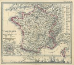 FRANKREICH. - Karte. - Gesamtkarte mit kleiner Nebenkarte "Seine-Departement".
Grenzkol. Kupferstich von Eulenstein bei Perthes, 1860 21 x 24 cm. (Artikelnr. 83CG)
Erfahren Sie mehr28,00 € Inkl. MwSt. -
76,00 € Inkl. MwSt.
-
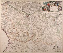
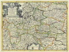 ÖSTERREICH. - Karte. - Cercle d'Austriche. Gesamtkarte mit schöner Kartusche.
Grenzkol. Kupferstich bei Covens & Mortier, um 1740, 22,5 x 29,5 cm. (Artikelnr. 14024AG)
Erfahren Sie mehr95,00 € Inkl. MwSt. -
ELSASS. - Karte. - Von dem Elsasz.
Holzschnitt aus Seb. Münster, "Cosmographia", um 1590, 9 x 13,5 cm.
Nicht genordete Gebietskarte mit dem Rheinlauf zwischen Basel und Straßburg. - Auf der ganzen Buchseite. (Artikelnr. 33795EG)
Erfahren Sie mehr92,00 € Inkl. MwSt. -
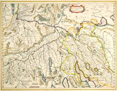
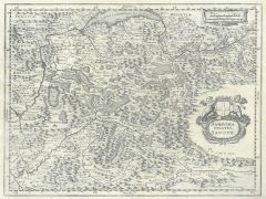 SAVOYEN. - Karte. - Sabavdia ducatus Savoye.
Kupferstich aus Gottfried, "Archontologia", 1649, 26,5 x 35,5 cm.
Zeigt das Gebiet südlich des Genfer Sees, im Westen Grenoble, im Osten die Walliser Alpen. Mit Kartusche. (Artikelnr. 6266AG)
Erfahren Sie mehr80,00 € Inkl. MwSt. -
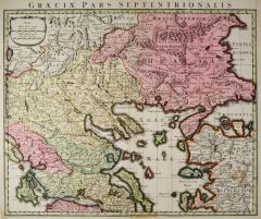 GRIECHENLAND. - Karte. - Graeciae Pars Septentrionalis.
Altkol. Kupferstich bei Covens & Mortier, um 1740, 47 x 58 cm.
Zeigt Griechenland ohne den Peloponnes und mit der westlichen Türkei. - Mit Kopftitel. Kräftiges altes Kolorit. (Artikelnr. 24667CG)
Erfahren Sie mehr320,00 € Inkl. MwSt. -
 DÄNEMARK. - Jütland. - Karte. - Iutia septentrionalis.
Kupferstich von G. Mercator, um 1580, 29 x 40 cm.
Jütlandkarte von Horsens im Süden bis Aalborg im Norden. - Breitrandig, mit lateinischem Text auf der Rückseite. (Artikelnr. 25687CG)
Erfahren Sie mehr200,00 € Inkl. MwSt. -
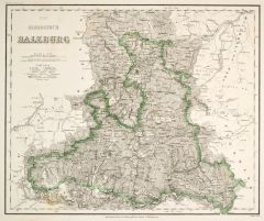 SALZBURG. - Karte. - Das Herzogthum Salzburg.
Grenzkol. Stahlstich aus Meyer bei BI, um 1865, 29,5 x 35,5 cm.
Espenhorst, PP 3.4 (Meyer-Ravenstein 1862-1884). - Aus: Joseph Meyer's "Hand-Atlas", redigiert von Ludwig Ravenstein (1838-1915). (Artikelnr. 19277BG)
Erfahren Sie mehr140,00 € Inkl. MwSt. -
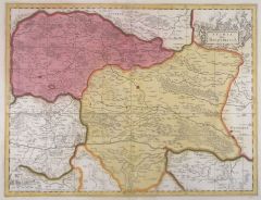 STEIERMARK. - Karte. - Stiria vulgo Steyrmarck.
Altkol. Kupferstich von Valck & P. Schenk d.Ä., um 1710, 38,5 x 49 cm.
Gesamtkarte mit figürlicher Titelkartusche rechts oben und kleinem Meilenzeiger mit Putte links unten. Breitrandig. (Artikelnr. 10131CG)
Erfahren Sie mehr180,00 € Inkl. MwSt. -
SCHWEIZ. - Karte. - Die Schweiz. Gesamtkarte.
Farblithographie nach Scrobel aus Andree bei Velhagen & Klasing, 1893, 36,5 x 46,5 cm.
Espenhorst, PP 5.1.3. - Aus: Richard Andree's "Allgemeiner Handatlas" (3. Ausgabe, Auflage 1893). - (Artikelnr. 35545EG)
Erfahren Sie mehr75,00 € Inkl. MwSt. -
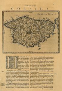
 KORSIKA. - Karte. - Corsica Insula. Gesamtkarte.
Altkol. Kupferstich bei Blaeu, um 1660, 18 x 24 cm (Darstellung).
Auf der vollen Buchseite (49,5 x 29 cm). - Leicht gebräunt, links ein hinterlegter Randeinriss. (Artikelnr. 2763GG)
Erfahren Sie mehr220,00 € Inkl. MwSt. -
 KORSIKA. - Karte. - Corsica Insula. Gesamtkarte.
Kupferstich bei Blaeu, um 1660, 18 x 24 cm (Darstellung).
Auf der vollen Buchseite (46 x 27,5 cm). - Gebräunt und links unten kleine Randläsuren (Artikelnr. 2762GG)
Erfahren Sie mehr180,00 € Inkl. MwSt. -
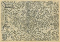
 ARTOIS. - Karte. - Tabula Comitatus Artesiae. Grafschaft Artois.
Altkol. Kupferstich von de Wit, um 1720, 46,5 x 55 cm.
Mit schöner, figürlicher altkolorierter Kartusche! (Artikelnr. 4863CG)
Erfahren Sie mehr100,00 € Inkl. MwSt. -
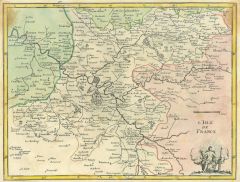 ISLE DE FRANCE. - Karte. - L'Isle de France.
Altkol. Kupferstich bei Crepy, 1767, 20 x 27 cm.
Mit kleiner figürlicher Kartusche rechts unten. Etwas gebräunt. (Artikelnr. 3634CG)
Erfahren Sie mehr66,00 € Inkl. MwSt. -
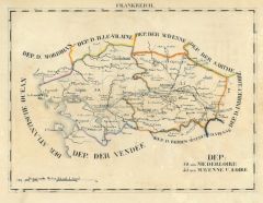 LOIRE. - Karte. - Dep: Niderloire, Mayenne u. Loire.
Grenzkol. Lithographie bei Schlieben, 1829, 19 x 26 cm.
Gebietskarte mit Nantes und Angers im Mittelpunkt. (Artikelnr. 18724AG)
Erfahren Sie mehr62,00 € Inkl. MwSt. -
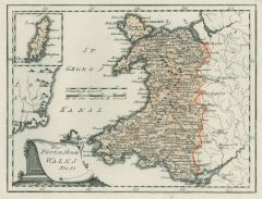 WALES. - Karte. - Das Fürstenthum Wales Nro. 85.
Altkol. Kupferstich von Reilly, um 1790, 20,5 x 27 cm.
Mit kleiner Nebenkarte der Isle of Man. (Artikelnr. 10365CG)
Erfahren Sie mehr110,00 € Inkl. MwSt. -
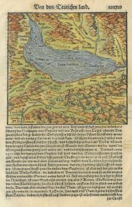 GENFER SEE. - Karte. - Lacus Lemanus Genffer See.
Kol. Holzschnitt aus Seb. Münster, "Cosmographia", 1598, 14,5 x 15,5 cm.
Auf der vollen Buchseite einer deutschen Ausgabe. (Artikelnr. 22743CG)
Erfahren Sie mehr128,00 € Inkl. MwSt. -
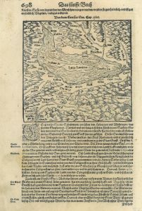 GENFER SEE. - Karte. - Von dem Genffer See.
Holzschnitt aus Seb. Münster, "Cosmographia", 1598, 14,5 x 15,5 cm.
Auf der vollen Buchseite einer deutschen Ausgabe. (Artikelnr. 16741BG)
Erfahren Sie mehr95,00 € Inkl. MwSt. -
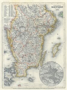 SCHWEDEN. - Karte. - Südliches Schweden nach Forsell 1852.
Grenzkol. Stahlstich aus Meyer's Zeitungsatlas, 1853, 25 x 18,5 cm.
Mit kleinem Plan von Stockholm rechts unten. (Artikelnr. 1188AG)
Erfahren Sie mehr43,00 € Inkl. MwSt. -
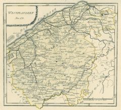
 FLANDERN. - Ostflandern. - Karte. - Ostflandern Nro. 172.
Grenzkol. Kupferstich von Reilly, um 1790, 26 x 28,5 cm.
Zeigt das Gebiet um Gent bis Mechelen, Derfting, Rupelmonde und Winkel. (Artikelnr. 17768AG)
Erfahren Sie mehr60,00 € Inkl. MwSt. -
 FLANDERN. - Westflandern. - Karte. - Westflandern Nro. 171.
Grenzkol. Kupferstich von Reilly, um 1790, 26 x 28,5 cm.
Zeigt das Gebiet zwischen Ostende, Veuren, Warneton, Meenen, Ingelminster und Aardenborg. (Artikelnr. 17767AG)
Erfahren Sie mehr60,00 € Inkl. MwSt. -
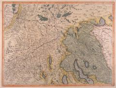
 ZÜRICH. - Karte. - Zurichgow et Basiliensis provincia.
Altkol. Kupferstich von J. Janssonius, um 1630, 38,5 x 49,5 cm.
Gesuchte Kantonskarte in sehr guter Erhaltung. - Verso mit Beschreibung in französisch. (Artikelnr. 27044CG)
Erfahren Sie mehr380,00 € Inkl. MwSt. -
 ZÜRICHGAU. - Karte. - Zurichgow et Basiliensis Provincia.
Altkol. Kupferstich von Mercator, um 1620, 36 x 47 cm.
Zeigt das Gebiet zwischen Basel, Radolfzell, Zürichsee und Solothurn. - Etwas gebräunt. (Artikelnr. 1067AG)
Erfahren Sie mehr320,00 € Inkl. MwSt. -
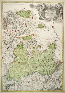 PRERAU. - Karte. - Marchionatus Moraviae circulus Preroviensis.
Altkol. Kupferstich von Johann Baptist Homann, um 1730, 80 x 56 cm.
Schöne, detailreiche Gebietskarte mit großer Kartusche, von zwei Platten gedruckt. (Artikelnr. 27332CG)
Erfahren Sie mehr300,00 € Inkl. MwSt. -
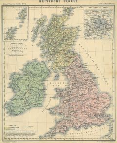 GROSSBRITANNIEN. - Karte. - Britische Inseln.
Farblithographie aus Adami-Kiepert bei Reimer, 1876, 33 x 27 cm.
Espenhorst, PP Anm. 27, S. 778. - Aus: Adami-Kiepert's "Schul-Atlas" (Ausgabe 1876). - Mit zwei Nebenkarten von London und den Shetland- und Orkney Inseln. (Artikelnr. 19424BG)
Erfahren Sie mehr55,00 € Inkl. MwSt. -
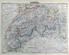 SCHWEIZ. - Karte. - Schweiz. Gesamtkarte.
Grenzkol. Kupferstich von Brose und Jaeck aus Kiepert bei Reimer, Berlin, 1875, 44,5 x 56 cm.
Espenhorst, PP 20.1.2. - Aus: Heinrich Kiepert's "Neuer Handatlas über alle Theile der Erde" (Ausgabe 1875). - Berichtigt 1874. (Artikelnr. 19013BG)
Erfahren Sie mehr70,00 € Inkl. MwSt.