Suchergebnisse für: "europa karte"
-
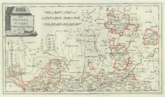
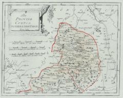
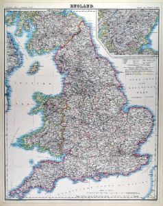
GROSSBRITANNIEN. - England. - Karte. - Anglia Cambdeni.
Altkol. Kupferstich von Mich. Kauffer bei Chr. Weigel, 1718, 39 x 33 cm.
Aus: Johann David Köhlers "Bequemer Schul= und Reisen=Atlas", 1718. - Zeigt das gesamte England mit Wales, rechts oben Kartusche. (Artikelnr. 18615BG)
Erfahren Sie mehr180,00 € Inkl. MwSt. -
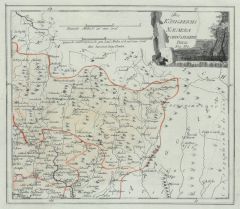
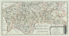
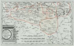
 POLEN. - Karte. - Das Köngireich Polen.
Grenzkol. Kupferstich von Eulenstein nach Stülpnagel aus Stieler bei Perthes, Gotha, dat. 1856, 42 x 35 cm.
Aus: A. Stieler's "Hand-Atlas". - Gesamtkarte in der von C. Vogel revidierten Fassung von 1863. (Artikelnr. 18027CG)
Erfahren Sie mehr95,00 € Inkl. MwSt. -
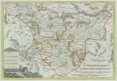
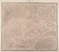 SCHAFFHAUSEN. - Karte. - Schaffhausen. Tübingen. Zürich.
Lithographie nach I.E. Woerl bei Herder, 1834, 38,5 x 44,5 cm.
Zeigt das Gebiet zwischen Waldshut, St. Blasien, Villingen, Messkirch, Überlinger See und Wyl. Die Strassen und Eisenbahnlinien in Rot gedruckt. (Artikelnr. 13582CG)
Erfahren Sie mehr190,00 € Inkl. MwSt. -
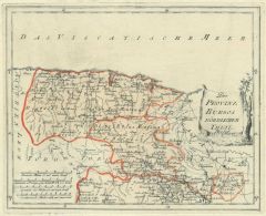
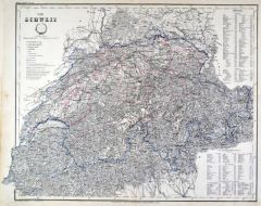 SCHWEIZ. - Karte. - Die Schweiz. Gesamtkarte.
Grenzkol. Stahlstich nach Radefeld und Ravenstein aus Meyer bei BI, um 1865, 34 x 44 cm.
Espenhorst, PP 3.4 (Meyer-Ravenstein 1862-1884). - Aus: Joseph Meyer's "Hand-Atlas", redigiert von Ludwig Ravenstein (1838-1915). (Artikelnr. 19272BG)
Erfahren Sie mehr90,00 € Inkl. MwSt. -
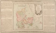 DÄNEMARK. - Karte. - Le Danemark. Gesamtkarte.
Altkol. Kupferstich von Brion de la Tour, 1790, 23 x 26 cm, mit Legende 28 x 48 cm.
Beidseitig montierte Legende, die geographische, statistische und historische Besonderheiten beschreibt. - Mit Kartusche. (Artikelnr. 7686AG)
Erfahren Sie mehr86,00 € Inkl. MwSt. -
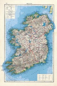 IRLAND. - Karte. - Irland.
Farblithographie nach Scrobel aus Andree bei Velhagen & Klasing, 1899, 36 x 23 cm.
Espenhorst, PP 5.1.4. - Aus: Richard Andree's "Allgemeiner Handatlas" (4. Ausgabe, Auflage 1899). - "Mit dieser Ausgabe wurde der ANDREE zum führenden deut... (Artikelnr. 35015EG)
Erfahren Sie mehr75,00 € Inkl. MwSt. -
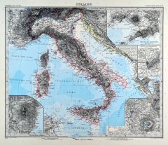
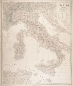 ITALIEN. - Karte. - Italien.
Grenzkol. Kupferstich von Jungmann nach Gräf und Kiepert, Weimar im Geograph. Institut, dat. 1862, 63 x 53 cm.
Espenhorst, PP 1.1.5. - Aus: Heinrich Kiepert's "Hand-Atlas" (42. Ausgabe, 1856/69). - Gesamtkarte einschließlich Korsika und ... (Artikelnr. 17086AG)
Erfahren Sie mehr120,00 € Inkl. MwSt. -
76,00 € Inkl. MwSt.
-
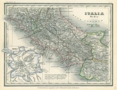 ITALIEN. - Mittelitalien. - Karte. - Italie media. Mit Plan von Rom.
Grenzkol. Stahlstich aus Meyer's Zeitungsatlas, 1853, 21 x 27,5 cm. (Artikelnr. 355AG)
Erfahren Sie mehr40,00 € Inkl. MwSt. -
66,00 € Inkl. MwSt.
-
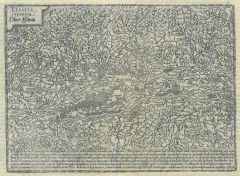 ELSASS. - Karte. - Alsatia superior Ober Elsas.
Kupferstich bei J. Bussemacher, 1594, 20 x 27 cm.
Nicht genordete Gebietskarte mit dem Rheinlauf am unteren Rand von Basel bis Rheinau. Oben links Titelkartusche. (Artikelnr. 13872CG)
Erfahren Sie mehr124,00 € Inkl. MwSt. -
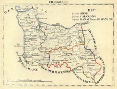
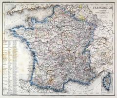
FRANKREICH. - Karte. - Frankreich. Gesamtkarte mit Korsika.
Farblithographie aus Sohr-Berghaus bei Flemming, Glogau, um 1885, 33 x 41 cm.
Espenhorst, PP 4.1.3. - Aus: Sohr-Berghaus's "Hand-Atlas über alle Teile der Erde". (Artikelnr. 19472BG)
Erfahren Sie mehr70,00 € Inkl. MwSt. -
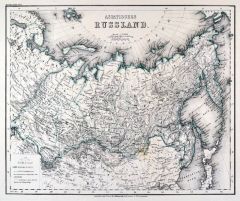 RUSSLAND. - Asiatischer Teil. - Karte. - Asiatisches Russland.
Grenzkol. Stahlstich aus Meyer bei BI, um 1865, 29,5 x 36 cm.
Espenhorst, PP 3.4 (Meyer-Ravenstein 1862-1884). - Aus: Joseph Meyer's "Hand-Atlas", redigiert von Ludwig Ravenstein (1838-1915). (Artikelnr. 19291BG)
Erfahren Sie mehr120,00 € Inkl. MwSt. -
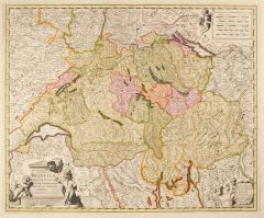 SCHWEIZ. - Karte. - Exactissima Helvetiae, Rhaetiae, Valesiae.
Altkol. Kupferstich von Nicolas Visscher, um 1670, 46 x 56 cm.
Flächenkolorierte Gesamtkarte mit dekorativen Kartuschen. - Im Bug an einer Stelle (ca. 6 cm) hinterlegt. (Artikelnr. 2420GG)
Erfahren Sie mehr380,00 € Inkl. MwSt. -
SCHWARZES MEER. - Karte. - Schwarzes Meer mit angrenzenden Küstenländern.
Kupferstich von J. Stridbeck, um 1700, 17 x 23 cm.
Von Joh. Stridbeck signiert und mit Privileg. (Artikelnr. 22193CG)
Erfahren Sie mehr100,00 € Inkl. MwSt. -
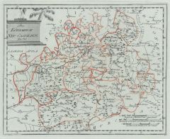 KASTILIEN. - Karte. - Das Koenigreich Neu Castilien Nro. 556.
Altkol. Kupferstich von Reilly, um 1790, 21,5 x 27 cm.
Zeigt Kastilien mit Toledo im Zentrum. (Artikelnr. 24430CG)
Erfahren Sie mehr140,00 € Inkl. MwSt. -
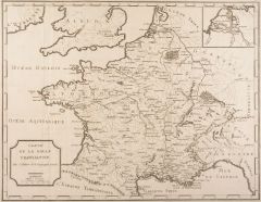 FRANKREICH. - Karte. - Carte de la Gaule Transalpine.
Kupferstich bei J.-R. Joly, 1801, 38 x 49 cm.
Gesamtkarte, rechts oben kleine Detailkarte mit der Rhein und Mosel Mündung. (Artikelnr. 14777BG)
Erfahren Sie mehr76,00 € Inkl. MwSt. -
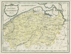 FLANDERN. - Karte. - Die Grafschaft Flandern Nro. 170.
Grenzkol. Kupferstich von Reilly, um 1790, 23,5 x 30,5 cm.
Zeigt das Gebiet zwischen Ostende, Nieuwkerke, Gramont und Antwerpen. (Artikelnr. 17766AG)
Erfahren Sie mehr50,00 € Inkl. MwSt. -
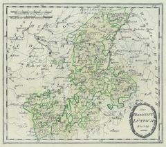 LÜTTICH. - Karte. - Das Hochstift Lüttich Nro. 269.
Grenzkol. Kupferstich von Reilly, um 1790, 25,5 x 28,5 cm.
Zeigt das Gebiet zwischen Namur, Charlemont, Malmedy Maastrich und Weert. (Artikelnr. 17815AG)
Erfahren Sie mehr90,00 € Inkl. MwSt. -
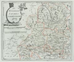
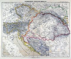 ÖSTERREICH und UNGARN. - Karte. - Österreichisch-Ungarische Monarchie.
Farblithographie aus Sohr-Berghaus bei Flemming, Glogau, um 1885, 33 x 40,5 cm.
Espenhorst, PP 4.1.3. - Aus: Sohr-Berghaus's "Hand-Atlas über alle Teile der Erde". (Artikelnr. 19459BG)
Erfahren Sie mehr80,00 € Inkl. MwSt. -
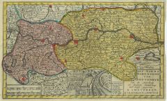 ÖSTERREICH. - Karte. - Het aards Hartogdom van Oostenryk.
Altkol. Kupferstich von G. Delisle bei J.B. Elwe, 1791, 18 x 26 cm.
Ober- und Niederösterreich mit kleinem Plan von Linz. (Artikelnr. 5498CG)
Erfahren Sie mehr120,00 € Inkl. MwSt. -
70,00 € Inkl. MwSt.
-
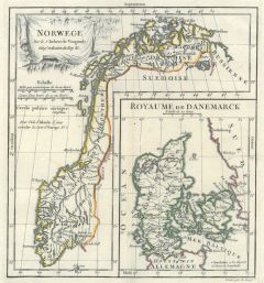 NORWEGEN. - Karte. - Norwege mit Nebenkarte "Royaume de Danemarck". Gesamtkarte.
Altkol. Kupferstich bei Robert de Vaugondy, um 1770, 24 x 22 cm. (Artikelnr. 25857CG)
Erfahren Sie mehr140,00 € Inkl. MwSt. -
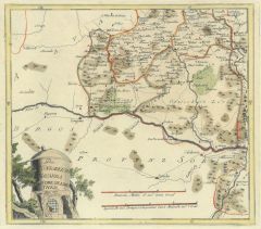
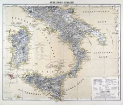 ITALIEN. - Süditalien. - Karte. - Südliches Italien.
Farblithographie aus Sohr-Berghaus bei Flemming, Glogau, um 1885, 33 x 40,5 cm.
Espenhorst, PP 4.1.3. - Aus: Sohr-Berghaus's "Hand-Atlas über alle Teile der Erde". - Mit zwei Nebenkarten von Sardinien und Malta. (Artikelnr. 19471BG)
Erfahren Sie mehr80,00 € Inkl. MwSt. -
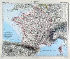
 FRANKREICH. - Karte. - Frankreich. Gesamtkarte.
Grenzkol. Stahlstich nach Radefeld und Ravenstein aus Meyer bei BI, um 1865, 29,5 x 35,5 cm.
Espenhorst, PP 3.4 (Meyer-Ravenstein 1862-1884). - Aus: Joseph Meyer's "Hand-Atlas", redigiert von Ludwig Ravenstein (1838-1915). - Mit einer klei... (Artikelnr. 19318BG)
Erfahren Sie mehr100,00 € Inkl. MwSt. -
 FRANKREICH. - Karte. - Frankreich. Gesamtkarte.
Kupferstich mit Farblithographie von Kühn und Kramer aus Stieler bei Perthes, Gotha, 1891, 33 x 40 cm.
Espenhorst, PP 2.1.1.1.8. - Aus: A. Stieler's "Hand-Atlas" (8. Ausgabe, Auflage 1891). - Gesamtkarte mit Einzeichnung der Départements... (Artikelnr. 19169BG)
Erfahren Sie mehr70,00 € Inkl. MwSt. -
NIEDERLANDE. - Karte. - Die Niederlande.
Farblithographie nach Scrobel aus Andree bei Velhagen & Klasing, 1893, 37 x 23,5 cm.
Espenhorst, PP 5.1.3. - Aus: Richard Andree's "Allgemeiner Handatlas" (3. Ausgabe, Auflage 1893). - Zeigt im Süden einen Teil von Belgien, im Osten Köln... (Artikelnr. 35546EG)
Erfahren Sie mehr60,00 € Inkl. MwSt. -
GROSSBRITANNIEN. - England. - Karte. - England.
Grenzkol. Kupferstich von Lechner und Eyb aus Kiepert bei Reimer, Berlin, 1875, 57 x 45 cm.
Espenhorst, PP 20.1.2. - Aus: Heinrich Kiepert's "Neuer Handatlas über alle Theile der Erde" (Ausgabe 1875). - Berichtigt 1872. - Übersichtskarte... (Artikelnr. 19065BG)
Erfahren Sie mehr75,00 € Inkl. MwSt. -
 GROSSBRITANNIEN. - England. - Karte. - England.
Grenzkol. Kupferstich von Lechner und Eyb aus Kiepert bei Reimer, Berlin, 1871, 57 x 45 cm.
Espenhorst, PP 20.1.2. - Aus: Heinrich Kiepert's "Neuer Handatlas über alle Theile der Erde" (Ausgabe 1871). - Berichtigt 1870. - Übersichtskarte... (Artikelnr. 19100BG)
Erfahren Sie mehr75,00 € Inkl. MwSt. -
ITALIEN. - Karte. - Italien. Gesamtkarte.
Grenzkol. Kupferstich von Reyher und Seitz aus Kiepert bei Reimer, Berlin, 1875, 55 x 43,5 cm.
Espenhorst, PP 20.1.2. - Aus: Heinrich Kiepert's "Neuer Handatlas über alle Theile der Erde" (Ausgabe 1875). - Berichtigt 1874. - Mit einer Ins... (Artikelnr. 19068BG)
Erfahren Sie mehr90,00 € Inkl. MwSt. -
ITALIEN. - Karte. - Italien. Gesamtkarte.
Grenzkol. Kupferstich von Jungmann nach Kiepert und Gräf, Weimar im Geograph. Institut, dat. 1857, 64,5 x 54,5 cm.
Espenhorst, PP 1.1.5. - Mit Farbangaben für den Kirchenstaat, die Königreiche Neapel-Sizilien, Sardinien und Lombardo-Ven... (Artikelnr. 33150EG)
Erfahren Sie mehr110,00 € Inkl. MwSt. -
ITALIEN. - Karte. - Italien. Gesamtkarte.
Grenzkol. Kupferstich von Reyher und Seitz aus Kiepert bei Reimer, Berlin, 1871, 55 x 43,5 cm.
Espenhorst, PP 20.1.2. - Aus: Heinrich Kiepert's "Neuer Handatlas über alle Theile der Erde" (Ausgabe 1871). - Berichtigt 1870. - Mit einer Ins... (Artikelnr. 19093BG)
Erfahren Sie mehr90,00 € Inkl. MwSt. -
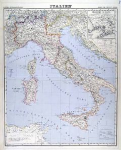
 ITALIEN. - Karte. - Italien. Gesamtkarte.
Kupferstich mit Farblithographie von Kühn nach Scherrer aus Stieler bei Perthes, Gotha, 1891, 33 x 40 cm.
Espenhorst, PP 2.1.1.1.8. - Aus: A. Stieler's "Hand-Atlas" (8. Ausgabe, Auflage 1891). - Mit 4 Nebenkarten von Neapel, Turin, Rom un... (Artikelnr. 19166BG)
Erfahren Sie mehr90,00 € Inkl. MwSt. -
ITALIEN. - Karte. - Italien. Gesamtkarte.
Grenzkol. Kupferstich von Metzeroth nach Weiland, Weimar im Geograph. Institut, dat. 1830, 38,5 x 32,5 cm.
Espenhost, PP 1.2.2. - Aus dem verkleinerten "Hand-Atlas ... für Bürgerschulen und Zeitungsleser" (sog. Bund-Ausgabe). - Seltener ... (Artikelnr. 33296EG)
Erfahren Sie mehr100,00 € Inkl. MwSt. -
 ITALIEN. - Karte. - Italien. Gesamtkarte.
Grenzkol. Kupferstich von Reyher und Seitz aus Kiepert bei Reimer, Berlin, 1861, 55 x 43,5 cm.
Espenhorst, PP 20.1.1. - Aus: Heinrich Kiepert's "Neuer Handatlas über alle Theile der Erde" (Ausgabe 1861). - Berichtigt 1860. - Mit einer Ins... (Artikelnr. 19138BG)
Erfahren Sie mehr90,00 € Inkl. MwSt. -
ITALIEN. - Norditalien. - Karte. - Oberitalien.
Farblithographie nach Scrobel aus Andree bei Velhagen & Klasing, 1893, 23 x 36 cm.
Espenhorst, PP 5.1.3. - Aus: Richard Andree's "Allgemeiner Handatlas" (3. Ausgabe, Auflage 1893). - Zeigt im Norden Südtirol ab Meran, im Süden Livorno un... (Artikelnr. 35551EG)
Erfahren Sie mehr75,00 € Inkl. MwSt.