Suchergebnisse für: "europa karte"
-
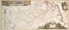
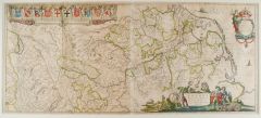
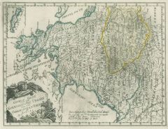
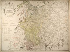
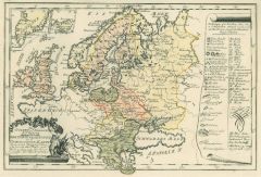 EUROPA. - Karte. - Das östliche und nördliche Europa. Dritte Einleitungs- und Uebersichtskarte.
Grenzkol. Kupferstich von Reilly, um 1790, 23,5 x 35,5 cm.
Karte mit England im Westen, im Südosten bis zum Schwarzen Meer. Mit zwei kleinen Nebenkarten von Grönland und Island und großer Legende mit gestochenen Erklärungen auf der rec... (Artikelnr. 10332CG)
Erfahren Sie mehr90,00 € Inkl. MwSt. -
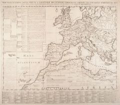 EUROPA. - Karte. - Nouvelle Carte pour servir a l'histoire de l'Empire d'Occident.
Kupferstich bei Chatelain, um 1710, 50 x 58 cm.
Historische Gesamtkarte Europas mit der nordafrikanischen Küste. Am unteren Rand und links umfangreiche, gestochene Erklärungen. Faltspuren. (Artikelnr. 3617CG)
Erfahren Sie mehr160,00 € Inkl. MwSt. -
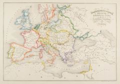
EUROPA. - Karte. - Europa zu Übersicht der politischen Verhältnisse. Gesamtkarte bis zum Ural.
Grenzkol. Kupferstich nach Berghaus aus Stieler bei Perthes, Gotha, 1866, 31 x 41 cm.
Espenhorst, PP 2.1.1.1.4. - Aus: A. Stieler's "Hand-Atlas" (4. Ausgabe, Auflage 1866). - Mittelbug verso verstärkt. Links am Rand (im Meer) ein Fleck vo... (Artikelnr. 34896EG)
Erfahren Sie mehr80,00 € Inkl. MwSt. -
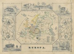 EUROPA. - Karte. - Europa. Gesamtkarte (10 x 13 cm), umgeben von historischen Szenen und Tieren.
Grenzkol. Kupferstich bei J. Berlin, 1853, 16 x 20,5 cm.
Espenhorst, PP 63,5. - Im Rand gering unfrisch. (Artikelnr. 26796CG)
Erfahren Sie mehr100,00 € Inkl. MwSt. -
EUROPA. - Karte. - Übersicht der politischen Eintheilungen Europas, mit insgesamt neun Einzelkarten auf einem Blatt.
Altkol. Lithographie von C. Hellfarth bei J. Perthes, Gotha, 1862, 33,5 x 39 cm.
Espenhorst, PP 38.2; vgl. Abb. S. 1056, Illustration Nr. 38.10; aus "E. von Sydow's methodischer Hand-Atlas". - Vorhanden: Deutschland, mit drei Nebenkarten: ... (Artikelnr. 32896EG)
Erfahren Sie mehr100,00 € Inkl. MwSt. -
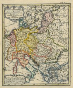 EUROPA. - Karte. - Conspectus generalis omnium regionum, quae ad Franco-Romanum v. Romano-Germanicum Imperium unquam pertinuerunt Pars II Orientalior.
Altkol. Kupferstich von Johann Matthias Hase, um 1740, 20 x 16 cm.
Die flächenkolorierte Karte zeigt Mitteleuropa, im Westen Paris, im Osten Kiew, im Süden Sizilien, im Norden die Alandinseln (Schweden). - Oben rechts "Tab.XX". (Artikelnr. 42968EG)
Erfahren Sie mehr100,00 € Inkl. MwSt. -
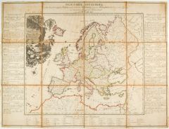
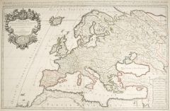 EUROPA. - Karte. - L'Europe distingueé suivant l'esten due de ses Principales Parties scavoir Les Isles Britanniques, La Scandinavie, La Moscovie, La France, L'Allemagne....
Grenzkolorierter Kupferstich von Cordier bei G. Sanson, um 1690, 57,5 x 89 cm.
Grenzkolorierte Gesamtkarte von Island bis zur nordafrikanischen Küste, im Osten bis zur Wolgamündung bei Astrachan. - Mit großer Titelkartusche links oben, ... (Artikelnr. 24269CG)
Erfahren Sie mehr780,00 € Inkl. MwSt. -
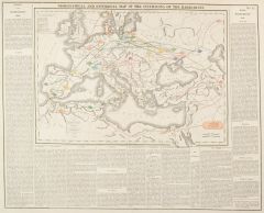 EUROPA. - Karte. - Geographical an Historical Map of the Incursions of the Barbarians. Gesamtkarte mit den Völkerwanderbewegungen in Europa, Nordafrika und dem Nahen Osten.
Grenzkol. Kupferstich von Kneass, Young & Co bei M. Carey, Philadelphia, dat. 1821, 27,5 x 38,5 cm.
Von den Hunnen 376 n.Chr. über Araber, Normannen und Sarazenen bis zu Saladin 1193. Unten und seitlich ausführliche Legende zu den einzel... (Artikelnr. 32992EG)
Erfahren Sie mehr118,00 € Inkl. MwSt. -
 EUROPA. - Karte. - Uebersichts-Karte für die Zeit vom westphälischen Frieden bis zur französischen Revolution 1789. Gesamtkarte Europas von Marokko bis zum kaspischen Meer.
Altkol. Lithographie von J. Loewenberg bei B. Herder, Freiburg, um 1790, 33 x 48 cm. (Artikelnr. 2660GG)
Erfahren Sie mehr150,00 € Inkl. MwSt. -
EUROPA. - Karte. - Empire Romain à l'époche de l'invasion des barbares sous le règne d'Honorius l'an 406 de J.C.. Das Römische Reich z.Zt. der Völkerwanderung unter Kaiser Honorius 406. Historische Karte.
Grenzkol. Kupferstich aus Delamarche, dat. 1833, 27,5 x 40,5 cm.
Aus: Felix Delamarche's "Atlas de la Géographie ancienne, du moyen-age et moderne". - Der Ingenieur und Mechaniker für Erd- und Himmelsgloben übernahm 1811 das Atlantenges... (Artikelnr. 34851EG)
Erfahren Sie mehr70,00 € Inkl. MwSt. -
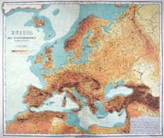
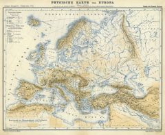 EUROPA. - Physische Karte. - Physische Karte von Europa.
Farblithographie aus Adami-Kiepert bei Reimer, 1876, 25,5 x 33 cm.
Espenhorst, PP Anm. 27, S. 778. - Aus: Adami-Kiepert's "Schul-Atlas" (Ausgabe 1876). (Artikelnr. 19414BG)
Erfahren Sie mehr65,00 € Inkl. MwSt. -
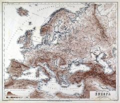
EUROPA. - Gebirge und Gewässer. - Karte. - Orographisch-Hydrographische Karte von Europa.
Kupferstich von C. Jungmann nach Weiland, Weimar im Geograph. Institut, dat. 1857, 50 x 62,5 cm.
Espenhorst, PP 1.1.5. - Mit "Erklaerung der, die einzelnen Bergspitzen und Gebirgstheile bezeichnenden Buchstaben." (Artikelnr. 33127EG)
Erfahren Sie mehr130,00 € Inkl. MwSt. -
 EUROPA. - Gebirge und Gewässer. - Karte. - Oro-Hydrographische Karte von Europa.
Stahlstich mit Farblithographie nach Ravenstein aus Meyer bei BI, um 1865, 32 x 38 cm.
Espenhorst, PP 3.4 (Meyer-Ravenstein 1862-1884). - Aus: Joseph Meyer's "Hand-Atlas", redigiert von Ludwig Ravenstein (1838-1915). (Artikelnr. 19293BG)
Erfahren Sie mehr130,00 € Inkl. MwSt. -
EUROPA. - Physische Karte. - Europa, Physische Übersicht.
Farblithographie nach Wolf bei Spamer, 1902, 31,5 x 41,5 cm.
Espenhorst, PP 23.2. - Aus: O. Spamer's "Grosser Hand-Atlas" (2. Ausgabe, Auflage 1902). - In drei Flächenfarben: Unter dem Meeresspiegel, Flachland, Bergland. - Verso Typograph... (Artikelnr. 35067EG)
Erfahren Sie mehr80,00 € Inkl. MwSt. -
 EUROPA. - Wirtschaft. - Karte. - Neue Carte von Europa welche die merkwürdigsten Producte und vornehmsten Handelspläze nebst dem Flächen-Inhalt aller europäischen Länder in deutschen Quadrat=Meilen enhält. Zu beiden Seiten der Karte
Grenzkol. Kupferstich in 12 Segmenten auf Leinen nach A.F.W. Crome, Dessau, 1782, 43 x 51 cm (Karte); 56 x 73 cm (mit Legende).
Erste Auflage. - Vgl. ADB, IV, 606 f.; Engelmann I, 263. - Der Volkswirt und Statistiker August Friedrich Wilhe... (Artikelnr. 41441EG)
Erfahren Sie mehr600,00 € Inkl. MwSt. -
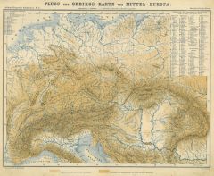 EUROPA. - Gebirge und Gewässer. - Karte. - Fluss und Gebirgs-Karte von Mittel-Europa.
Farblithographie aus Adami-Kiepert bei Reimer, 1876, 25,5 x 33,5 cm.
Espenhorst, PP Anm. 27, S. 778. - Aus: Adami-Kiepert's "Schul-Atlas" (Ausgabe 1876). (Artikelnr. 19416BG)
Erfahren Sie mehr65,00 € Inkl. MwSt. -
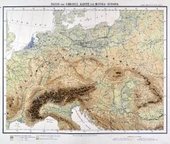 EUROPA. - Gebirge und Gewässer. - Karte. - Fluss- und Gebirgs-Karte von Mittel-Europa.
Farblithographie aus Sohr-Berghaus bei Flemming, Glogau, um 1885, 31 x 40 cm.
Espenhorst, PP 4.1.2. - Aus: Sohr-Berghaus's "Hand-Atlas über alle Teile der Erde". (Artikelnr. 19440BG)
Erfahren Sie mehr95,00 € Inkl. MwSt. -
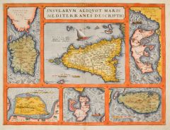 EUROPA. - Mittelmeer. - Karte. - Insvlarvm aliqvot maris Mediterranei descriptio. Karte der Mittelmeerinseln.
Kol. Kupferstich von A. Ortelius, um 1580, 36 x 47,5 cm.
Von den Broecke 142 (lateinische Ausgabe). - Sizilien in der Mitte, umgeben von Sardinien, Djerba, Elba, Malta und Korfu. - Dekorative Karte in kräftigem Kolorit, auf Japanpapier au... (Artikelnr. 1219GG)
Erfahren Sie mehr800,00 € Inkl. MwSt. -
RUSSLAND. - Karte. - Europäische Russland. Gesamtkarte in 4 Blättern.
4 Farblithographien aus Sohr-Berghaus bei Flemming, Glogau, um 1885, je 40,5 x 33 cm.
Espenhorst, PP 4.1.3. - Aus: Sohr-Berghaus's "Hand-Atlas über alle Teile der Erde". - Die 4-teilige Karte zeigt den europäischen Teil von Russland von ... (Artikelnr. 19502BG)
Erfahren Sie mehr340,00 € Inkl. MwSt. -
EUROPA. - Gebirge und Gewässer. - Karte. - Fluss- und Gebirgs-Karte von Mittel-Europa.
Lithographie von Müller nach Handtke aus Sohr bei Flemming, Glogau, um 1850, 31 x 40 cm.
Espenhorst, PP 4.1.1. - Aus: Karl Sohr's "Vollständiger Universal=Handatlas der neueren Erdbeschreibung". - Zeigt Mitteleuropa von Kopenhagen bis zu... (Artikelnr. 35245EG)
Erfahren Sie mehr80,00 € Inkl. MwSt. -
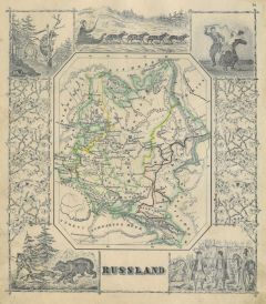 RUSSLAND. - Karte. - Russland. Karte des europäischen Teils, umgeben von historischen Szenen und Tierdarstellungen.
Grenzkol. Kupferstich bei J. Berlin, 1853, 16 x 20,5 cm.
Espenhorst, PP 63,5. - Im Rand gering unfrisch. (Artikelnr. 27133CG)
Erfahren Sie mehr100,00 € Inkl. MwSt. -
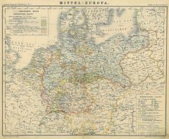 DEUTSCHLAND. - Karte. - Mittel-Europa.
Farblithographie aus Adami-Kiepert bei Reimer, 1876, 26,5 x 33,5 cm.
Espenhorst, PP Anm. 27, S. 778. - Aus: Adami-Kiepert's "Schul-Atlas" (Ausgabe 1876). - Zeigt das Deutsche Kaiserreich. - Der Bug hinterlegt. (Artikelnr. 19418BG)
Erfahren Sie mehr60,00 € Inkl. MwSt. -
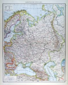
 RUSSLAND. - Karte. - Europäisches Russland.
Farblithographie von Scrobel aus Andree bei Velhagen & Klasing, 1899, 46,5 x 36,5 cm.
Espenhorst, PP 5.1.4. - Aus: Richard Andree's "Allgemeiner Handatlas" (4. Ausgabe, Auflage 1899). - "Mit dieser Ausgabe wurde der ANDREE zum führenden d... (Artikelnr. 35029EG)
Erfahren Sie mehr70,00 € Inkl. MwSt. -
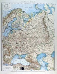
RUSSLAND. - Karte. - Europäisches Russland.
Farblithographie nach Wolf aus Spamer, 1902, 41,5 x 31,5 cm.
Espenhorst, PP 23.2. - Aus: O. Spamer's "Grosser Hand-Atlas" (2. Ausgabe, Auflage 1902). - Zeigt das Gebiet von der Deutschen Grenze bis zum Ural, im Süden die heutige Türkei, ... (Artikelnr. 35101EG)
Erfahren Sie mehr95,00 € Inkl. MwSt. -
RUSSLAND. - Karte. - Europäisches Russland.
Farblithographie von Scrobel aus Andree bei Velhagen & Klasing, 1893, 46,5 x 36,5 cm.
Espenhorst, PP 5.1.3. - Aus: Richard Andree's "Allgemeiner Handatlas" (3. Ausgabe, Auflage 1893). - Zeigt Rußland von der deutsch-ungarischen Grenze bis... (Artikelnr. 35555EG)
Erfahren Sie mehr95,00 € Inkl. MwSt. -
EUROPA. - Karolinger. - Karte. - Imperium Caroli Magni. Das Europa Karls des Großen.
Kupferstich von Janssonius, Amsterdam, um 1640, 37 x 52 cm.
Die Inschrift oben rechts in bekrönter Wappenkartusche, links eine Windrose, auf dem Mittelmeer Segelschiffe. - Im Mittelbug leicht faltig. Breitrandig. (Artikelnr. 35852EG)
Erfahren Sie mehr200,00 € Inkl. MwSt. -
 RHEIN. - Karte. - Rhenus Fluviorum Europae celemberrimus.
Altkol. Kupferstich von Willem Janszoon Blaeu, Amsterdam, um 1630, 41,5 x 95,5 cm.
Der Rheinlauf vom Bodensee bis zur Nordsee. - Mit altkolorierter von Putten gehaltenen Wappenkartusche der angrenzenden Länder, sowie altkolorierter Kartus... (Artikelnr. 27362CG)
Erfahren Sie mehr650,00 € Inkl. MwSt. -
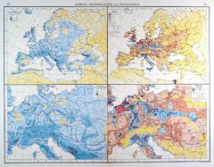
EUROPA. - Meteorologie. - Einwohner. - Karte. - Niederschläge und Volksdichte. Vier Karten auf einem Blatt.
Farblithographie nach Scrobel aus Andree bei Velhagen & Klasing, 1900, 37,5 x 49,5 cm.
Espenhorst, PP 5.1.4. - Aus: Richard Andree's "Allgemeiner Handatlas" (4. Ausgabe, Auflage 1900). - Die Karten zeigen Bevölkerungsdichte bzw. Niedersch... (Artikelnr. 705FG)
Erfahren Sie mehr95,00 € Inkl. MwSt. -
 EUROPA. - Eisenbahn. - Karte. - Eisenbahn-Nachträge zu Kiepert's Handatlas, für alle Europäischen Länder.
Lithographie aus Kiepert bei Reimer, Berlin, 1860, 33 x 44 cm. - Espenhorst, A.S., 20.1. (Artikelnr. 34771EG)
Erfahren Sie mehr95,00 € Inkl. MwSt. -
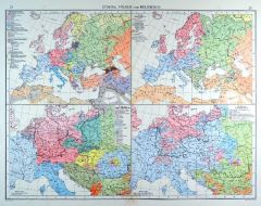
EUROPA. - Volkszugehörigkeit. - Religion. - Karte. - Völker und Religionen. Vier Karten auf einem Blatt.
Farblithographie nach Scrobel aus Andree bei Velhagen & Klasing, 1900, 37,5 x 49,5 cm.
Espenhorst, PP 5.1.4. - Aus: Richard Andree's "Allgemeiner Handatlas" (4. Ausgabe, Auflage 1900). - Die Karten zeigen Völkerverteilung und Sprachgebiet... (Artikelnr. 706FG)
Erfahren Sie mehr90,00 € Inkl. MwSt. -
BALKAN. - Karte. - Europäische Türkei. Griechenland.
Grenzkol. Kupferstich von Dellinger nach Gräf, Weimar im Geograph. Institut, 1876, 56 x 50 cm.
Espenhorst, AS, 1.1.6. - Zeigt das Gebiet von Linz, Wien und dem Djepr im Norden, im Osten Odessa, die westliche Schwarzmeerküste und das west... (Artikelnr. 32590EG)
Erfahren Sie mehr110,00 € Inkl. MwSt. -
 RUSSLAND. - Karte. - Das europäische Russland.
Grenzkol. Kupferstich nach Gräf und Kiepert, Weimar im Geograph. Institut, dat. 1860, 57 x 46 cm.
Espenhorst, PP 1.1.5. - Aus: Kiepert, "Hand-Atlas", 42. Ausgabe (1856/69). - Gesamtkarte zwischen Eismeer, Ostsee, dem Schwarzen- und dem Ka... (Artikelnr. 17087AG)
Erfahren Sie mehr120,00 € Inkl. MwSt. -
 RHEIN. - Karte. - Rhenus Fluviorum Europae celemberrimus.
Altkol. Kupferstich von W.J. Blaeu, Amsterdam, um 1630, 41,5 x 95,5 cm.
Der Rheinlauf vom Bodensee bis zur Nordsee. - Mit altkolorierter von Putten gehaltenen Wappenkartusche der angrenzenden Länder, sowie altkolorierter Kartusche mit dre... (Artikelnr. 3060AG)
Erfahren Sie mehr850,00 € Inkl. MwSt. -
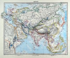 ASIEN. - Karte. - Asien. Gesamtkarte mit Europa.
Kupferstich mit Farblithographie von Hafermalz aus Stieler bei Perthes, Gotha, 1891, 33 x 40 cm.
Espenhorst, PP 2.1.1.1.8. - Aus: A. Stieler's "Hand-Atlas" (8. Ausgabe, Auflage 1891). (Artikelnr. 19183BG)
Erfahren Sie mehr100,00 € Inkl. MwSt. -
ASIEN. - Karte. - Asien. Gesamtkarte, mit Europa.
Grenzkol. Kupferstich von Schmidt nach Lange aus Stein bei Hinrichs, 1857, 40 x 47,5 cm.
Espenhorst, PP 31.1.1.2. - Aus: C.G.D. Stein "Neuer Atlas der ganzen Erde" (29. Ausgabe, Auflage 1857). (Artikelnr. 34916EG)
Erfahren Sie mehr100,00 € Inkl. MwSt. -
 BALKAN. - Karte. - General Karte von dem Koenigreiche Ungarn und dem Osmanischen Reiche in Europa Nro. 1.
Grenzkol. Kupferstich von Reilly, um 1790, 30 x 23 cm.
Karte des Gebietes von Kroatien bis zum Schwarzen Meer und von Galizien bis Griechenland. (Artikelnr. 10333CG)
Erfahren Sie mehr90,00 € Inkl. MwSt. -
 EUROPA. - Gebirge und Gewässer. - Karte. - Europa nach seinen Oro-Hydrographischen Verhältnissen. Bis zum Ural.
Kupferstich mit Farblithographie nach Delitsch, Weimar im Geograph. Institut, 1886, 52 x 62 cm.
Espenhorst, PP 1.1.6. - Aus: Heinrich Kiepert's "Grosser Hand-Atlas" (49. Ausgabe, Auflage 1886). (Artikelnr. 35140EG)
Erfahren Sie mehr90,00 € Inkl. MwSt. -
EUROPA. - Mittelmeer. - Karte. - Imperii Romani Tabula Augusti Principatu. Karte des Römischen Reiches unter Augustus.
Grenzkol. Kupferstich aus Delamarche, dat. 1833, 28 x 41 cm.
Aus: Felix Delamarche's "Atlas de la Géographie ancienne, du moyen-age et moderne". - Der Ingenieur und Mechaniker für Erd- und Himmelsgloben übernahm 1811 das Atlantengeschä... (Artikelnr. 34842EG)
Erfahren Sie mehr90,00 € Inkl. MwSt. -
RUSSLAND. - Karte. - Karte des Europäischen Rußlands und der angrenzenden Länder.
Farblithographie nach Petermann bei Pethers, Gotha, dat. 1855, 60,5 x 48 cm.
Mit genauer Bezeichnung der Strassen und Angabe einiger historisch-physikalisch-geographischen Hauptmomente. - In acht Segmente unterteilt, dort hinterlegte Rande... (Artikelnr. 32981EG)
Erfahren Sie mehr85,00 € Inkl. MwSt. -
FRANKEN. - Roser, Hans. - Klöster in Franken. Werke und Gestalten einer europäischen Kulturlandschaft.
Freiburg im Breisgau, Eulen Verlag, 1988.
24,5 x 15,5 cm. 408 S. Mit 87 Abbildungen und 1 Karte. OPp. mit OUmschlag. (Artikelnr. 6868BB)
Erfahren Sie mehr12,00 € Inkl. MwSt. -
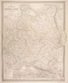
RUSSLAND. - Karte. - Europäisches Russland ... in zwey Blatt.
2 grenzkol. Kupferstiche nach Stülpnagel aus Stieler bei Perthes, Gotha, dat. 1845, je 31 x 37,5 cm.
Espenhorst, PP 2.1.1.1. - Aus: A. Stieler's "Hand-Atlas" (First Edition, "the one least often found" (=die seltenste Ausgabe)). - Zeigt R... (Artikelnr. 33200EG)
Erfahren Sie mehr140,00 € Inkl. MwSt. -
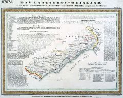
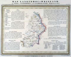 WEIN. - Languedoc. - Das Languedoc-Weinland 1. Karte des Dept. Gard mit den Tavel-, Conteperdrix- und Calvissons - Weinen. Mit Beschreibung des Weinbaus, der Rebsorten, der Charakteristik der Weine.
Altkol. Lithographie von Hesse nach Hellrung, um 1840, 30 x 40 cm.
Aus: "Atlas der vorzüglichen Weinberge in Europa, Nr.17". (Artikelnr. 6708AG)
Erfahren Sie mehr104,00 € Inkl. MwSt. -
 WEIN. - Languedoc. - Das Languedoc-Weinland 2. Karte des Dept. l'Herault mit den Lunel-, Frontignan-, Beziers- und Cette - Weinen. Mit Beschreibung des Weinbaus, der Rebsorten, der Charakteristik der Weine.
Altkol. Lithographie von Hesse nach Hellrung, um 1840, 30 x 40 cm.
Aus: "Atlas der vorzüglichen Weinberge in Europa, Nr.18". (Artikelnr. 6707AG)
Erfahren Sie mehr104,00 € Inkl. MwSt. -
 RUSSLAND. - Karte. - Europäisches Russland. Bis zum Ural.
Farblithographie aus Andree bei Velhagen & Klasing, 1881, 46,5 x 36,5 cm.
Espenhorst, PP 5.1.1. - Aus: Richard Andree's "Allgemeiner Handatlas" (1. Ausgabe, Auflage 1881). - Verso 4 weitere Darstellungen: "Schweden und Norwegen", "Völkerk... (Artikelnr. 35337EG)
Erfahren Sie mehr95,00 € Inkl. MwSt. -
 EUROPA. - Meteorologie. - Einwohner. - Karte. - Niederschläge und Volksdichte. Vier Karten auf einem Blatt.
Farblithographie von Maasch nach Ambrosius aus Andree bei Velhagen & Klasing, 1899, 37,5 x 49,5 cm.
Espenhorst, PP 5.1.4. - Aus: Richard Andree's "Allgemeiner Handatlas" (4. Ausgabe, Auflage 1899). - "Mit dieser Ausgabe wurde der ANDREE zu... (Artikelnr. 34982EG)
Erfahren Sie mehr95,00 € Inkl. MwSt. -
 EUROPA. - Volkszugehörigkeit. - Religion. - Karte. - Völker und Religionen. Vier Karten auf einem Blatt.
Farblithographie von Franke nach Thomas aus Andree bei Velhagen & Klasing, 1899, 37,5 x 49,5 cm.
Espenhorst, PP 5.1.4. - Aus: Richard Andree's "Allgemeiner Handatlas" (4. Ausgabe, Auflage 1899). - "Mit dieser Ausgabe wurde der ANDREE zum f... (Artikelnr. 34983EG)
Erfahren Sie mehr90,00 € Inkl. MwSt. -
 RUSSLAND. - Karte. - Karte von dem Russischen Reiche in Europa. Neu verzeichnet und herausgegeben.
Grenzkol. Kupferstich von F. Müller bei F.J.J. Reilly, dat. 1796, 56 x 75 cm.
Die große Übersichtskarte mit Kartusche links oben und mehreren gestochenen Erklärungen. (Artikelnr. 26063CG)
Erfahren Sie mehr180,00 € Inkl. MwSt. -
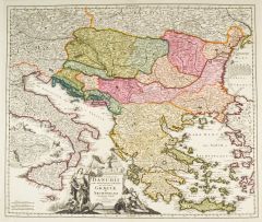 GRIECHENLAND. - Karte. - Fluviorum in Europa principis Danubii cum Adiacentibus Regnis nec non totius Graeciae et Archipelagi Novißima Tabula.
Altkol. Kupferstich von Johann Baptist Homann, um 1710, 47 x 56 cm.
Die Flächenkolorierte Karte zeigt das gesamte Griechenland mit ägäischen Inseln, sowie die Adria mit Italien, Kroatien, Bosnien, Montenegro, Albanien und Teile von Bulg... (Artikelnr. 20192BG)
Erfahren Sie mehr380,00 € Inkl. MwSt. -
EUROPA. - Gebirge und Gewässer. - Karte. - Strom und Gebirgs-System von Mittel-Europa. Mitteleuropa mit Gewässern und Gebirgen.
Kupferstich von Carl Jättnig nach G. Heck, dat. 1845, 26 x 40,5 cm.
Zeigt das Gebiet von Südostengland bis Marseille, von Süddänemark bis in die Toskana, im Osten Dnjepr und Dnjester. (Artikelnr. 32998EG)
Erfahren Sie mehr78,00 € Inkl. MwSt.