Suchergebnisse für: "europa karte"
-
GRIECHENLAND. - Karte. - Turquie D'Europe.
Grenzkol. Kupferstich aus Delamarche, dat. 1833, 27 x 31 cm.
Aus: Felix Delamarche's "Atlas de la Géographie ancienne, du moyen-age et moderne". - Der Ingenieur und Mechaniker für Erd- und Himmelsgloben übernahm 1811 das Atlantengeschä... (Artikelnr. 34834EG)
Erfahren Sie mehr75,00 € Inkl. MwSt. -
SCHWEIZ. - Karte. - Schweiz. Gesamtkarte.
Grenzkol. Kupferstich von Eberhardt und Weiler nach Vogel aus Stieler bei Perthes, Gotha, 1868, 33 x 40 cm.
Espenhorst, PP 2.1.1.1.5. - Aus: A. Stieler's "Hand-Atlas" (5. Ausgabe, Auflage 1868). - Espenhorst S. 252: die Gruppen b-d der 5. ... (Artikelnr. 34882EG)
Erfahren Sie mehr80,00 € Inkl. MwSt. -
 SCHWEIZ. - Karte. - Die Schweiz.
Grenzkol. Kupferstich aus Stieler bei Perthes, Gotha, dat. 1834, 28 x 38 cm.
Espenhorst, PP 2.1.1.1 (vgl. dort die Illus. 2.41, S. 229). Aus: A. Stieler's "Hand-Atlas" (First Edition, "the one least often found" (=die seltenste Ausgabe)). ... (Artikelnr. 33208EG)
Erfahren Sie mehr90,00 € Inkl. MwSt. -
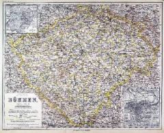 BÖHMEN. - Karte. - Königreich Böhmen.
Stahlstich mit Farblithographie nach Ravenstein aus Meyer bei BI, um 1865, 34 x 42,5 cm.
Espenhorst, PP 3.4 (Meyer-Ravenstein 1862-1884). - Aus: Joseph Meyer's "Hand-Atlas", redigiert von Ludwig Ravenstein (1838-1915). - Mit 2 Nebenkarten ... (Artikelnr. 19311BG)
Erfahren Sie mehr130,00 € Inkl. MwSt. -
SKANDINAVIEN. - Karte. - Scandinavien. Gesamtkarte.
Grenzkol. Kupferstich von Sulzer aus Kiepert bei Reimer, Berlin, 1858, 54 x 44 cm.
Espenhorst, PP 20.1.1. - Aus: Heinrich Kiepert's "Neuer Handatlas über alle Theile der Erde" (Ausgabe 1858). - Mit zwei kleinen Insetkarten von Island und ... (Artikelnr. 19015BG)
Erfahren Sie mehr80,00 € Inkl. MwSt. -
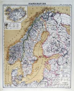 SKANDINAVIEN. - Karte. - Scandinavien. Gesamtkarte.
Grenzkol. Kupferstich von Sulzer aus Kiepert bei Reimer, Berlin, 1861, 54 x 44 cm.
Espenhorst, PP 20.1.1. - Aus: Heinrich Kiepert's "Neuer Handatlas über alle Theile der Erde" (Ausgabe 1861). - Mit zwei kleinen Insetkarten von Island und ... (Artikelnr. 19144BG)
Erfahren Sie mehr80,00 € Inkl. MwSt. -
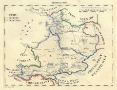
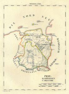 GRONINGEN. - Karte. - Prov: Gröningen und Drenthe. Mit Dollart-Mündung.
Grenzkol. Lithographie von O. Hermann bei Schlieben, 1829, 25,5 x 19 cm. (Artikelnr. 18708AG)
Erfahren Sie mehr60,00 € Inkl. MwSt. -
NEUCHATEL. - Karte. - Kaartje van Neuchatel en Valangin. Schöne Gebietskarte.
Altkol. Kupferstich von G. Delisle bei J.B. Elwe, 1791, 18 x 26 cm. (Artikelnr. 5488CG)
Erfahren Sie mehr95,00 € Inkl. MwSt. -
 NAVARRA. - Karte. - Des Koenigreichs Navarra südöstlicher Theil Nro. 586.
Altkol. Kupferstich von Reilly, um 1790, 25,5 x 26,5 cm (unten angerändert). (Artikelnr. 24453CG)
Erfahren Sie mehr110,00 € Inkl. MwSt. -
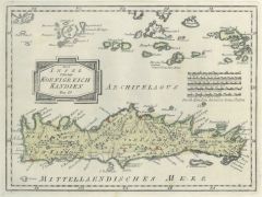
SERIFOS. - Karte. - Port de Serfanto. Grundriß mit kleinen Gebäuden.
Kol. Kupferstich von J. Roux, um 1800, 12,5 x 18,5 cm (leicht angeschmutzt). (Artikelnr. 18860AG)
Erfahren Sie mehr52,00 € Inkl. MwSt. -
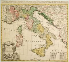 ITALIEN. - Karte. - Italia in suos Status.
Altkol. Kupferstich bei Homann Erben, um 1742, 50 x 58 cm.
Gesamtkarte mit großer, figürlicher Kartusche links unten und Kopftitel. Rechts unten Meilenzeiger - Auf Einfassungslinie beschnitten. (Artikelnr. 27368CG)
Erfahren Sie mehr280,00 € Inkl. MwSt. -
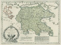
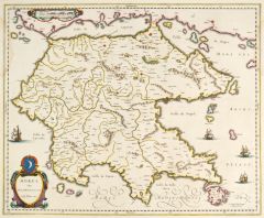 GRIECHENLAND. - Peloponnes. - Karte. - Morea olim Peloponensus.
Altkol. Kupferstich bei W.J. Blaeu, um 1640, 41,5 x 50,5 cm.
Mit kleiner altkolorierter Titelkartusche links unten. Verso mit lateinischem Text. - Links kleiner Wasserrand, sonst tadellos erhalten. (Artikelnr. 27078CG)
Erfahren Sie mehr280,00 € Inkl. MwSt. -
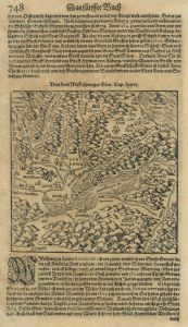 SCHWEIZ. - Karte. - Von dem Wifflispurger Gow.
Holzschnitt aus Seb. Münster, "Cosmographia", 1598, 15 x 15,5 cm.
Zeigt das Gebiet um Bern. Auf der vollen Buchseite einer deutschen Ausgabe, verso Gesamtansicht von Spiez. - Leicht gebräunt. (Artikelnr. 16739BG)
Erfahren Sie mehr95,00 € Inkl. MwSt. -
PORTUGAL. - Karte. - Portugallia ex deseriptione exactissima.
Altkol. Kupferstich bei Chr. Weigel, 1718, 40 x 34 cm.
Aus: Johann David Köhlers "Bequemer Schul= und Reisen=Atlas", 1718. - Dekorative Gesamtkarte, mit großer figürlicher Kartusche links oben. (Artikelnr. 18611BG)
Erfahren Sie mehr240,00 € Inkl. MwSt. -
PORTUGAL. - Karte. - Portugalliae et Algarbiae regna.
Altkol. Kupferstich von N. Visscher, um 1690, 46 x 56 cm.
Gesamtkarte mit zwei großen, figürlichen Kartuschen links oben und unten. Bugfalte unten mit winziger, nicht störender Fehlstelle. (Artikelnr. 20260CG)
Erfahren Sie mehr280,00 € Inkl. MwSt. -
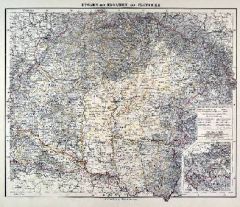
UNGARN. - Karte. - Ungarn und Galizien. Gesamtkarte.
Farblithographie nach Wolf aus Spamer, 1902, 31,5 x 41,5 cm.
Espenhorst, PP 23.2. - Aus O. Spamer "Grosser Hand-Atlas", 2. Ausgabe, Auflage 1902. - Verso Typographie, mit 8 Gebietskarten. (Artikelnr. 35086EG)
Erfahren Sie mehr95,00 € Inkl. MwSt. -
 120,00 € Inkl. MwSt.
 -
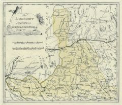
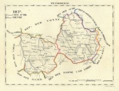 BURGUND. - Karte. - Dep: der Côte 'Or, der Nièvre.
Grenzkol. Lithographie von Hermann bei Schlieben, 1829, 20 x 15 cm.
Gebietskarte zwischen Nievers und Dijon. (Artikelnr. 18741AG)
Erfahren Sie mehr52,00 € Inkl. MwSt. -
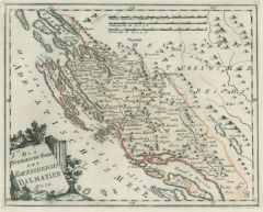
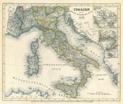 ITALIEN. - Karte. - Italien mit der dalmat.albanesischen Küste 1849.
Grenzkol. Stahlstich aus Meyer's Zeitungsatlas 1853, 19 x 28 cm.
Gesamtkarte mit drei Nebenkarten: Rom, Neapel, Malta. (Artikelnr. 353AG)
Erfahren Sie mehr30,00 € Inkl. MwSt. -
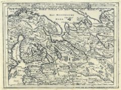 RUSSLAND. - Karte. - Russlands oder Moskoviens Nord-West-Theil.
Kupferstich von Bodenehr, um 1720, 17 x 23 cm.
Zeigt Russland dem Moscowischen Meer bis Moskau und von Stockholm bis Permawelick. (Artikelnr. 11118AG)
Erfahren Sie mehr90,00 € Inkl. MwSt. -
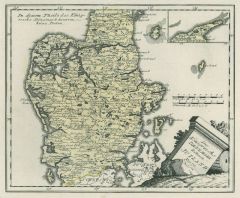
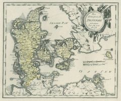
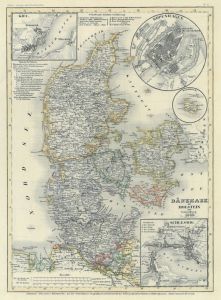 DÄNEMARK. - Karte. - Dänemark mit Holstein und Lauenburg 1849.
Grenzkol. Stahlstich aus Meyer's Zeitungsatlas, 1853, 25 x 18 cm.
Mit 4 Plänen von Stockholm, Bornholm, Schleswig und Kiel. (Artikelnr. 1093AG)
Erfahren Sie mehr43,00 € Inkl. MwSt. -
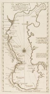 KASPISCHES MEER. - Karte. - Carte de la Merr Caspiene.
Kupferstich von Guillaume Delisle nach van Verden und Czariene, dat. 1725, 44 x 23 cm (rechts mit schmalem Rand). (Artikelnr. 2709GG)
Erfahren Sie mehr280,00 € Inkl. MwSt. -
RUSSLAND. - Karte. - Carte de la Russie d'Europe.
Grenzkol. Kupferstich nach A. Delamarche, dat. 1838, 41 x 29,5 cm.
Zeigt Rußland von Polen bis zum Ural, mit Grenzkolorit für die Provinzen. (Artikelnr. 32906EG)
Erfahren Sie mehr84,00 € Inkl. MwSt. -
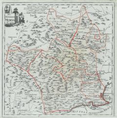 MURCIA. - Karte. - Das Königreich Murcia Nro. 570.
Altkol. Kupferstich von Reilly, um 1790, 28 x 27,5 cm.
Die Autonome Gemeinschaft Murcia liegt im Südosten Spaniens am Mittelmeer. - Unten angerändert. (Artikelnr. 24443CG)
Erfahren Sie mehr120,00 € Inkl. MwSt. -
 UNGARN. - Karte. - Ungarn mit Kroatien und Slavonien.
Farblithographie aus Sohr-Berghaus bei Flemming, Glogau, um 1885, 33 x 40,5 cm.
Espenhorst, PP 4.1.3. - Aus: Sohr-Berghaus's "Hand-Atlas über alle Teile der Erde". (Artikelnr. 19464BG)
Erfahren Sie mehr80,00 € Inkl. MwSt. -
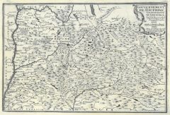 DAUPHINE. - Karte. - Gouvernement de Dauphine.
Kupferstich von Starckman bei Nicolas de Fer, 1705, 23 x 34 cm.
Gebietskarte mit der Rhone zwischen Lyon und St. Paul im Westen, im Osten bis Monstier und Chateau Dauphin, in der Mitte Grenoble. (Artikelnr. 15087AG)
Erfahren Sie mehr76,00 € Inkl. MwSt. -
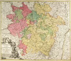 LOTHRINGEN. - Karte. - Lotharingae Tabula Generalis.
Altkol. Kupferstich von Johann Baptist Homann, um 1720, 49,5 x 57 cm.
Zeigt ganz Lothringen mit Nancy im Mittelpunkt. Im Nordosten noch das Saarland und Teile der Pfalz. - Mit großer figürlicher Kartusche links unten. (Artikelnr. 8938CG)
Erfahren Sie mehr190,00 € Inkl. MwSt. -
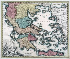 GRIECHENLAND. - Karte. - Graeciae Novae Tabula.
Altkol. Kupferstich von Mich. Kauffer bei Chr. Weigel, 1718, 32,5 x 40 cm.
Aus: Johann David Köhlers "Bequemer Schul= und Reisen=Atlas", 1718. - Zeigt Griechenland mit den ägäischen Inseln und Kreta, sowie die Küste der Türkei. (Artikelnr. 18664BG)
Erfahren Sie mehr220,00 € Inkl. MwSt. -
GRIECHENLAND. - Karte. - Turquie d'Europe & Grèce.
Altkol. Kupferstich von Lemercier bei Furne, Paris, um 1865, 42,5 x 34 cm.
Aus "Atlas de Géographie Militaire". - Griechenland und die Balkanstaaten vor der Vereinigung von Walachei und Moldawien 1859, im Osten die Westtürkei. (Artikelnr. 34785EG)
Erfahren Sie mehr95,00 € Inkl. MwSt. -
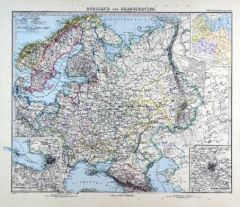 RUSSLAND. - Karte. - Russland und Skandinavien.
Kupferstich mit Farblithographie nach Habenicht aus Stieler bei Perthes, Gotha, 1891, 33 x 40 cm.
Espenhorst, PP 2.1.1.1.8. - Aus: A. Stieler's "Hand-Atlas" (8. Ausgabe, Auflage 1891). - Übersichtskarte mit drei Nebenkarten von "Russland'... (Artikelnr. 19182BG)
Erfahren Sie mehr90,00 € Inkl. MwSt. -
 OBERÖSTERREICH. - Karte. - Archiducatus Austriae Superioris.
Altkol. Kupferstich von J.B. Homann, um 1730, 48,5 x 58 cm.
Zeigt das Gebiet zwischen Salzburg, Braunau und Passau im Westen und Ypps im Osten mit den oberösterreichischen Seen im Mittelpunkt. Links oben Titelkartusche. - Rechts knapprand... (Artikelnr. 12254CG)
Erfahren Sie mehr280,00 € Inkl. MwSt. -
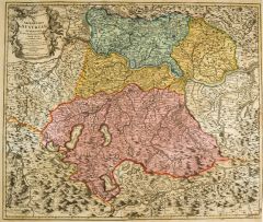
ÖSTERREICH. - Karte. - Die Österreichischen Alpenländer.
Farblithographie nach Scrobel aus Andree bei Velhagen & Klasing, 1893, 36,5 x 48 cm.
Espenhorst, PP 5.1.3. - Aus: Richard Andree's "Allgemeiner Handatlas" (3. Ausgabe, Auflage 1893). - Zeigt die Länder zwischen Bodensee und Wien bzw. Sch?... (Artikelnr. 35544EG)
Erfahren Sie mehr95,00 € Inkl. MwSt. -
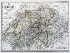
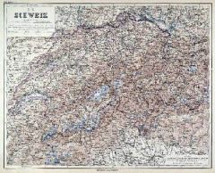 SCHWEIZ. - Karte. - Die Schweiz. Gesamtkarte.
Stahlstich mit Farblithographie nach Ravenstein aus Meyer bei BI, um 1865, 34 x 43 cm.
Espenhorst, PP 3.4 (Meyer-Ravenstein 1862-1884). - Aus: Joseph Meyer's "Hand-Atlas", redigiert von Ludwig Ravenstein (1838-1915). - Mit zwei kleinen Lö... (Artikelnr. 19305BG)
Erfahren Sie mehr100,00 € Inkl. MwSt. -
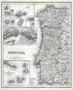 PORTUGAL. - Karte. - Das Königreich Portugal.
Grenzkol. Stahlstich nach Radefeld aus Meyer bei BI, um 1865, 39,5 x 29,5 cm.
Espenhorst, PP 3.4 (Meyer-Ravenstein 1862-1884). - Aus: Joseph Meyer's "Hand-Atlas", redigiert von Ludwig Ravenstein (1838-1915). - Mit Nebenkarten der Azoren, K... (Artikelnr. 19254BG)
Erfahren Sie mehr120,00 € Inkl. MwSt. -
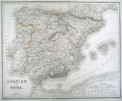 SPANIEN. - Karte. - Spanien und Portugal.
Grenzkol. Kupferstich von v.Eyb/Dellinger/Biedermann nach Franzisco Coello, Weimar im Geograph. Institut, 1876, 52,5 x 64,5 cm.
Espenhorst, AS, 1.1.6. - Im Norden bis Toulouse und Marseille, im Süden die Nordafrikanische Küste. Mit Bale... (Artikelnr. 32597EG)
Erfahren Sie mehr128,00 € Inkl. MwSt. -
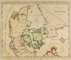 DÄNEMARK. - Karte. - Postkarte von Daenemark.
Altkol. Kupferstich von F.J.J. Reilly, um 1790, 36 x 43 cm.
Gesamtkarte mit Südschweden und Pommern mit der Insel Rügen. Mit Einzeichnung der Postverbindungen zu Lande und zu Wasser ("Wasserfahrt"). - Im Ganzen etwas gebräunt. Breitrand... (Artikelnr. 27710CG)
Erfahren Sie mehr250,00 € Inkl. MwSt. -
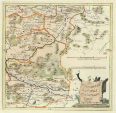
 GELDERN. - Karte. - Prov: Geldern un Oberyssel, mit dem Zuydersee.
Grenzkol. Lithographie von O. Hermann bei Schlieben, 1829, 19 x 26 cm. (Artikelnr. 18705AG)
Erfahren Sie mehr68,00 € Inkl. MwSt. -
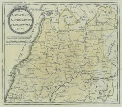
 UNGARN. - Karte. - Kreis jenseits der Theiss. Gespanschaft Bihar, Bekes.
Grenzkol. Lithographie bei Schlieben, 1829, 19 x 26 cm.
Gebietskarte mit Großwardein im Mittelpunkt. (Artikelnr. 18756AG)
Erfahren Sie mehr60,00 € Inkl. MwSt. -
MÄHREN. - Karte. - Kaartje van het Markgraafschap Moravien. Schöne Gebietskarte.
Altkol. Kupferstich von G. Delisle bei J.B. Elwe, 1791, 18 x 26 cm. (Artikelnr. 5500CG)
Erfahren Sie mehr114,00 € Inkl. MwSt. -
48,00 € Inkl. MwSt.
-
 100,00 € Inkl. MwSt.