Suchergebnisse für: "europa karte"
-
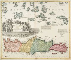 KRETA. - Karte. - Insula Creta hodie Candia.
Altkol. Kupferstich von Johann Baptist Homann, um 1740, 49 x 57,5 cm.
Gesamtkarte mit den umliegenden Inseln. Links große figürliche Kartusche. - Am Mittelbug zwei kleine Braunfleckchen, sonst wohl erhalten. (Artikelnr. 20163CG)
Erfahren Sie mehr600,00 € Inkl. MwSt. -
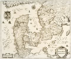 DÄNEMARK. - Karte. - Sedes Belli Dano. Suecici.
Kupferstich von Merian aus "Theatrum Europaeum", 1667, 32 x 38,5 cm.
Zeigt Dänemark mit Holstein, Schleswig, Südschweden und der Küste von Mecklenburg und Pommern mit Rügen. Rechts unten Titelkartusche, links Wappen. (Artikelnr. 18594CG)
Erfahren Sie mehr124,00 € Inkl. MwSt. -
BOULOGNE. - Karte. - Calete siu et bononiensi. Nicht genordete Gesamtkarte.
Kupferstich bei Botero, um 1590, 8 x 10,5 cm (auf der vollen Buchseite). (Artikelnr. 16384CG)
Erfahren Sie mehr48,00 € Inkl. MwSt. -
 POLEN. - Karte. - Compendiosa Polonia Repraesentatio Polen Mitt Angraentzenden Laendern.
Kupferstich von J. Stridbeck, um 1700, 16x 21 cm.
Von Joh. Stridbeck signiert und mit Privileg. (Artikelnr. 22195CG)
Erfahren Sie mehr120,00 € Inkl. MwSt. -
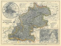 OBERÖSTERREICH. - Karte. - Erz- Herzogthum Oesterreich: Ob der Enns 1849.
Grenzkol. Stahlstich aus Meyer's Zeitungsatlas, 1853, 18 x 24,5 cm.
Mit zwei Nebenkarten: Linz und Salzburg. (Artikelnr. 537BG)
Erfahren Sie mehr48,00 € Inkl. MwSt. -
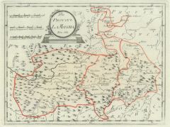
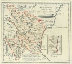 VALENCIA. - Karte. - Des Königreichs Valencia mittlerer Theil Nro. 573.
Altkol. Kupferstich von Reilly, um 1790, 26 x 29 cm. - Mit kleiner Nebenkarte. (Artikelnr. 24445CG)
Erfahren Sie mehr130,00 € Inkl. MwSt. -
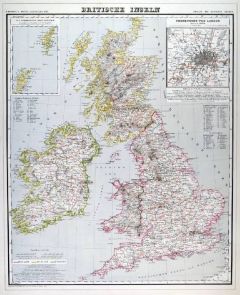
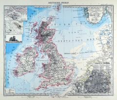
GROSSBRITANNIEN. - Karte. - Britische Inseln.
Grenzkol. Kupferstich von Brose und Jaeck aus Kiepert bei Reimer, Berlin, 1875, 55 x 44,5 cm.
Espenhorst, PP 20.1.2. - Aus: Heinrich Kiepert's "Neuer Handatlas über alle Theile der Erde" (Ausgabe 1875). - Berichtigt 1871. - Schöne Gesamt... (Artikelnr. 19046BG)
Erfahren Sie mehr80,00 € Inkl. MwSt. -
GROSSBRITANNIEN. - Karte. - Britische Inseln.
Grenzkol. Kupferstich von Brose und Jaeck aus Kiepert bei Reimer, Berlin, 1871, 55 x 44,5 cm.
Espenhorst, PP 20.1.2. - Aus: Heinrich Kiepert's "Neuer Handatlas über alle Theile der Erde" (Ausgabe 1871). - Berichtigt 1869. - Schöne Gesamt... (Artikelnr. 19099BG)
Erfahren Sie mehr80,00 € Inkl. MwSt. -
GROSSBRITANNIEN. - Karte. - Britische Inseln.
Grenzkol. Kupferstich von Brose und Jaeck aus Kiepert bei Reimer, Berlin, 1861, 55 x 44,5 cm.
Espenhorst, PP 20.1.1. - Aus: Heinrich Kiepert's "Neuer Handatlas über alle Theile der Erde" (Ausgabe 1861). - Schöne Gesamtkarte von Großbrit... (Artikelnr. 19142BG)
Erfahren Sie mehr80,00 € Inkl. MwSt. -
 GROSSBRITANNIEN. - Karte. - Britische Inseln.
Grenzkol. Kupferstich von Brose und Jaeck aus Kiepert bei Reimer, Berlin, 1858, 55 x 44,5 cm.
Espenhorst, PP 20.1.1. - Aus: Heinrich Kiepert's "Neuer Handatlas über alle Theile der Erde" (Ausgabe 1858). - Schöne Gesamtkarte von Großbrit... (Artikelnr. 19027BG)
Erfahren Sie mehr80,00 € Inkl. MwSt. -
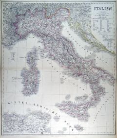
ITALIEN. - Karte. - Italien. Gesamtkarte.
Grenzkol. Kupferstich von Stier nach Petermann aus Stieler bei Perthes, Gotha, 1866, 33 x 40,5 cm.
Espenhorst, PP 2.1.1.1.4. - Aus: A. Stieler's "Hand-Atlas" (4. Ausgabe, Auflage 1866). - Mit 3 Nebenkarten von Turin mit Umgebung, Rom mit C... (Artikelnr. 34903EG)
Erfahren Sie mehr80,00 € Inkl. MwSt. -
 ITALIEN. - Karte. - Italien. Gesamtkarte.
Grenzkol. Kupferstich von Jungmann nach Kiepert, Weimar im Geograph. Institut, 1876, 63 x 54 cm.
Espenhorst, AS, 1.1.6. - Zeigt Italien mit Sizilien und Sardinien, dazu Korsika und die Maltesischen Inseln, im Süden Tunis und das östliche... (Artikelnr. 32601EG)
Erfahren Sie mehr130,00 € Inkl. MwSt. -
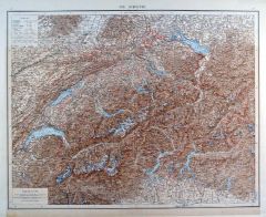
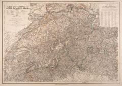 SCHWEIZ. - Karte. - Die Schweiz.
Grenzkol. Kupferstich von Kratz nach Gräf, Weimar im Geograph. Institut, um 1860, 45 x 63,5 cm.
Espenhorst, PP 1.1.5. - Aus: Kiepert, "Hand-Atlas", 42. Ausgabe (1856/69). - Gesamtkarte zwischen Neuchateler- und Genfer See bis zum Bodensee... (Artikelnr. 980AG)
Erfahren Sie mehr104,00 € Inkl. MwSt. -
SCHOTTLAND. - Karte. - Scotland, mit Nebenkarte "Shetland Inseln".
Grenzkol. Kupferstich von Maedel nach Weiland, Weimar im Geograph. Institut, dat. 1857, 54 x 46 cm.
Espenhorst, PP 1.1.5. - Zeigt im Südwesten die Irische Nordostküste. (Artikelnr. 33157EG)
Erfahren Sie mehr108,00 € Inkl. MwSt. -
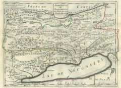 NEUCHATEL. - Karte. - Principauté de Neuchatel et Valangin.
Altkol. Kupferstich bei Le Rouge aus "Atlas Portatif", 1759, 21 x 28 cm.
Gebietskarte bis zum Neuchateler See im Süden, im Norden von Ronde bis Renans. (Artikelnr. 8573AG)
Erfahren Sie mehr130,00 € Inkl. MwSt. -
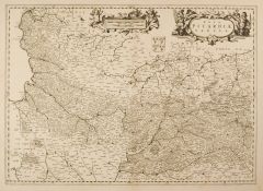
 ARTOIS. - Karte. - Tabula Comitatus Artesiae. Die Grafschaft Artois.
Kupferstich von Frederik de Wit, um 1690, 46,5 x 55 cm.
Mit schöner, figürlicher Kartusche oben rechts. Etwas gebräunt. (Artikelnr. 41437EG)
Erfahren Sie mehr150,00 € Inkl. MwSt. -
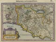 ITALIEN. - Mittelitalien. - Karte. - Latium nunc Campagna di Roma.
Kol. Kupferstich von Mercator, um 1600, 14,5 x 20 cm.
Mit Kopftitel und kolorierter Kartusche links unten. - Dekorativ gerahmt. (Artikelnr. 25988CG)
Erfahren Sie mehr180,00 € Inkl. MwSt. -
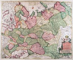 RUSSLAND. - Karte. - Imperii Russici, sive Moscoviae, Status Generalis.
Altkol. Kupferstich von de Wit, um 1650, 44,5 x 55 cm.
Flächenkolorierte Gesamtkarte von Russland. Mit altkolorierter Kartusche mit Wappenrechts unten. (Artikelnr. 18019BG)
Erfahren Sie mehr500,00 € Inkl. MwSt. -
48,00 € Inkl. MwSt.
-
66,00 € Inkl. MwSt.
-
57,00 € Inkl. MwSt.
-
 GROSSBRITANNIEN. - Karte. - Britische Inseln. Gesamtkarte.
Kupferstich mit Farblithographie nach Petermann aus Stieler bei Perthes, Gotha, 1891, 33 x 40 cm.
Espenhorst, PP 2.1.1.1.8. - Aus: A. Stieler's "Hand-Atlas" (8. Ausgabe, Auflage 1891). - Mit 6 Nebenkarten von Southampton, Helgoland, Helgol... (Artikelnr. 19173BG)
Erfahren Sie mehr75,00 € Inkl. MwSt. -
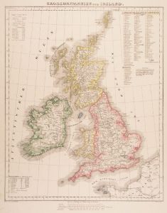 GROSSBRITANNIEN. - Karte. - Grossbritannien und Ireland.
Grenzkol. Lithographie von Thomas nach Handtke aus Sohr bei Flemming, Glogau, 1853, 37 x 30 cm.
Espenhorst, PP 4.1.1. - Aus: Karl Sohr's "Vollständiger Universal=Handatlas der neueren Erdbeschreibung". - Mit Angabe der politischen Einteil... (Artikelnr. 18039CG)
Erfahren Sie mehr80,00 € Inkl. MwSt. -
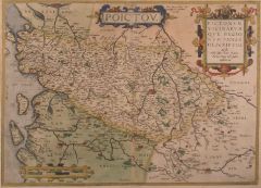 POITIERS. - Karte. - Poictov. Pictonum vicinarum.
Altkol. Kupferstich von Ortelius, dat. 1579, 36 x 50 cm.
Zeigt das Gebiet um Poitiers zwischen Nantes, Lymoges, Le Blanc und la Haye. Mit zwei altkol. Titelkartuschen und Meilenzeiger. - Insgesamt ein wenig gebräunt, aber sehr schön. (Artikelnr. 17059AG)
Erfahren Sie mehr180,00 € Inkl. MwSt. -
LYON. - Karte. - Lyon. Kleinteilige Umgebungskarte.
Kupferstich von Jacobs nach Duvotenay aus Lavallée bei Furne, Paris, 1858, 14 x 23 cm.
Aus: Théophile Lavallée's "Atlas de Géographie Militaire". - Zeigt im Süden La Mulatiere, im Westen Eculy, im Norden St. Didier, im Osten Les Brott... (Artikelnr. 34872EG)
Erfahren Sie mehr60,00 € Inkl. MwSt. -
ITALIEN. - Süditalien. - Karte. - Unter Italien.
Grenzkol. Kupferstich von Haubold nach Kiepert, Weimar im Geograph. Institut, 1876, 58,5 x 51,5 cm.
Espenhorst, AS, 1.1.6. - Zeigt Unteritalien mit Sizilien, im Norden ab Orvieto und Terni. Mit zwei Nebenkarten: Neapel mit Campagna Felice... (Artikelnr. 32600EG)
Erfahren Sie mehr128,00 € Inkl. MwSt. -
SIZILIEN. - Karte. - Sizilien und Sardinien.
Farblithographie nach Scrobel aus Andree bei Velhagen & Klasing, 1893, 23 x 36 cm.
Espenhorst, PP 5.1.3. - Aus: Richard Andree's "Allgemeiner Handatlas" (3. Ausgabe, Auflage 1893). - Zeigt im Norden die Liparischen Inseln, im Süden Malta.... (Artikelnr. 35552EG)
Erfahren Sie mehr75,00 € Inkl. MwSt. -
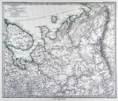
RUSSLAND. - Karte. - Nordost-Russland. Gebietskarte.
Grenzkol. Kupferstich von Alt nach Petermann aus Stieler bei Perthes, Gotha, 1867, 33,5 x 40 cm.
Espenhorst, PP 2.1.1.1.4. - Aus: A. Stieler's "Hand-Atlas" (4. Ausgabe, Auflage 1867). - Zeigt das Nördliche Eismeer und die Gouvernements Ar... (Artikelnr. 34888EG)
Erfahren Sie mehr100,00 € Inkl. MwSt. -
 RUSSLAND. - Karte. - Nordost-Russland. Gebietskarte.
Grenzkol. Kupferstich von Alt nach Petermann aus Stieler bei Perthes, Gotha, 1875, 33,5 x 40 cm.
Espenhorst, PP 2.1.1.1.6. - Aus: A. Stieler's "Hand-Atlas" (6. Ausgabe, Auflage 1875). - Zeigt das Nördliche Eismeer und die Gouvernements Ar... (Artikelnr. 35382EG)
Erfahren Sie mehr90,00 € Inkl. MwSt. -
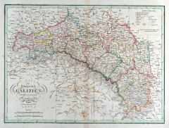 GALIZIEN. - Karte. - Das Königreich Galizien.
Grenzkol. Kupferstich nach Weiland, Weimar im Geograph. Institut, dat. 1830, 29 x 39,5 cm.
Espenhost, PP 1.2.2. - Aus dem verkleinerten "Hand-Atlas ... für Bürgerschulen und Zeitungsleser" (sog. Bund-Ausgabe). - Seltener ("greater rarity... (Artikelnr. 33311EG)
Erfahren Sie mehr100,00 € Inkl. MwSt. -
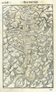 WALLIS. - Karte. - Valesia Wallisser land.
Holzschnitt aus Seb. Münster, "Cosmographia", um 1590, 26 x 16 cm.
Nicht genordet. Zeigt den Lauf der Rotten zwischen Furka bzw. Grimsel und S. Maurice bzw. Martinach, mittig Brig mit "Thermae Brieger Bad". Verso Text zum Wallis in Deutsc... (Artikelnr. 33781EG)
Erfahren Sie mehr130,00 € Inkl. MwSt. -
 NIEDERÖSTERREICH. - Karte. - Archiducatus Austriae Inferioris.
Altkol. Kupferstich von Johann Baptist Homann, um 1735, 48 x 57 cm.
Zeigt das Gebiet zwischen Mauthausen an der Donau und dem Neusiedler See. Die verschiedenen Kreise ("Viertel") sind durch unterschiedliche Kolorierung hervorgehoben. Recht... (Artikelnr. 15332AG)
Erfahren Sie mehr190,00 € Inkl. MwSt. -
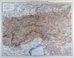 ÖSTERREICH. - Karte. - Die Österreichischen Alpenländer.
Farblithographie aus Andree bei Velhagen & Klasing, 1881, 36 x 47,5 cm.
Espenhorst, PP 5.1.1. - Aus: Richard Andree's "Allgemeiner Handatlas" (1. Ausgabe, Auflage 1881). - Zeigt die Länder zwischen Bodensee und Wien bzw. Schärding und Is... (Artikelnr. 35330EG)
Erfahren Sie mehr95,00 € Inkl. MwSt. -
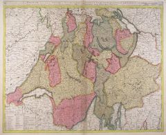
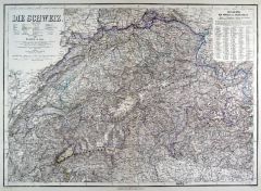 SCHWEIZ. - Karte. - Die Schweiz. Gesamtkarte.
Grenzkol. Kupferstich von Kratz und Luther nach Gräf und Geyer, Weimar im Geograph. Institut, 1876, 45,5 x 63,5 cm.
Espenhorst, AS, 1.1.6. - Im Norden bis zum Südschwarzwald und zum Bodensee, im Süden bis Mailand. Mit Titel, Maßstab un... (Artikelnr. 32598EG)
Erfahren Sie mehr110,00 € Inkl. MwSt. -
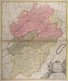
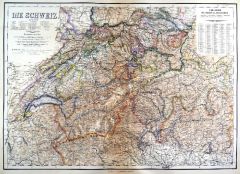 SCHWEIZ. - Karte. - Die Schweiz. Gesamtkarte.
Kupferstich mit Farblithographie nach Gräf, Weimar im Geograph. Institut, 1886, 46 x 64,5 cm.
Espenhorst, PP 1.1.6. - Aus: Heinrich Kiepert's "Grosser Hand-Atlas" (49. Ausgabe, Auflage 1886). - Zeigt im Norden den Bodensee, im Osten Glurn... (Artikelnr. 35157EG)
Erfahren Sie mehr95,00 € Inkl. MwSt. -
 SCHWEIZ. - Karte. - Die Schweiz. Gesamtkarte.
Farblithographie aus Andree bei Velhagen & Klasing, 1881, 37 x 47 cm.
Espenhorst, PP 5.1.1. - Aus: Richard Andree's "Allgemeiner Handatlas" (1. Ausgabe, Auflage 1881). - Verso 3 weitere Darstellungen: "Italien Nördliche Hälfte" bis zur L... (Artikelnr. 35332EG)
Erfahren Sie mehr80,00 € Inkl. MwSt. -
BÖHMEN. - Karte. - Das Königreich Boehmen.
Grenzkol. Kupferstich nach Weiland, Weimar im Geograph. Institut, dat. 1830, 30,5 x 38 cm.
Espenhost, PP 1.2.2. - Aus dem verkleinerten "Hand-Atlas ... für Bürgerschulen und Zeitungsleser" (sog. Bund-Ausgabe). - Seltener ("greater rarity... (Artikelnr. 33283EG)
Erfahren Sie mehr110,00 € Inkl. MwSt. -
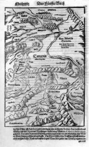
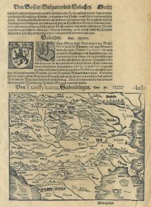 SIEBENBÜRGEN. - Karte. - Von Transsylvania, Siebenbürgen.
Holzschnitt aus Seb. Münster, "Cosmographia", um 1590, 15 x 19 cm.
Zeigt das Gebiet zwischen Lemberg im Norden und Mazdonien im Süden, im Südosten Konstantinopel, im Osten die Westküste des Schwarzen Meres, im Westen Dalmatien. - Auf d... (Artikelnr. 26726CG)
Erfahren Sie mehr120,00 € Inkl. MwSt. -
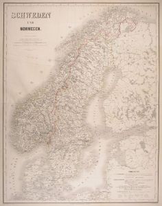 SKANDINAVIEN. - Karte. - Schweden und Norwegen
Grenzkol. Kupferstich von Haubold und Poppey nach Gräf, Weimar im Geograph. Institut, dat. 1864, 66 x 52 cm.
Espenhorst, PP 1.1.5. - Aus: Kiepert, "Hand-Atlas", 42. Ausgabe (1856/69). - Gesamtkarte bis einschließlich Dänemark (Dänemark... (Artikelnr. 17084AG)
Erfahren Sie mehr104,00 € Inkl. MwSt. -
SKANDINAVIEN. - Karte. - Schweden und Norwegen.
Grenzkol. Kupferstich von Bürck nach Weiland, Weimar im Geograph. Institut, dat. 1827, 61 x 44 cm.
Espenhorst, PP 1.1.2. - Zeigt unten Dänemark bis Flensburg, rechts die Finnische Küste. Mit Maßstäben und Zeichenerklärungen. - Im Ran... (Artikelnr. 33075EG)
Erfahren Sie mehr104,00 € Inkl. MwSt. -
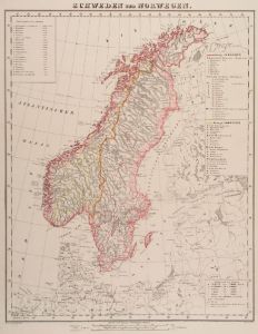 SKANDINAVIEN. - Karte. - Schweden und Norwegen.
Grenzkol. Lithographie von Thomas nach Handtke aus Sohr bei Flemming, Glogau, 1853, 35 x 28 cm.
Espenhorst, PP 4.1.1. - Aus: Karl Sohr's "Vollständiger Universal=Handatlas der neueren Erdbeschreibung". - Mit Angabe der politischen Einteil... (Artikelnr. 18043CG)
Erfahren Sie mehr75,00 € Inkl. MwSt. -
SKANDINAVIEN. - Karte. - Schweden und Norwegen.
Grenzkol. Kupferstich von Wibel/Haubold/Poppey nach Gräf, Weimar im Geograph. Institut, 1876, 66 x 51,5 cm.
Espenhorst, AS, 1.1.6. - Zeigt das Gebiet von Norwegen, Schweden, Finnland und Dänemark, im Osten Estland und St. Petersburg, im ... (Artikelnr. 32591EG)
Erfahren Sie mehr94,00 € Inkl. MwSt. -
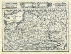
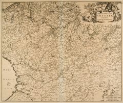
 PICARDIE. - Karte. - Nova Picardiae Tabula.
Kupferstich von Janssonius, um 1690, 39 x 54,5 cm.
Im Zentrum die Somme mit Amiens und S. Quentin, im Nordwesten die Atlantikküste von Calais bis Dieppe, im Süden Noyon und Laon, im Osten bis Namur und Reims. (Artikelnr. 2414GG)
Erfahren Sie mehr220,00 € Inkl. MwSt. -
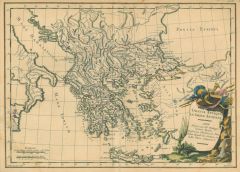 GRIECHENLAND. - Karte. - Graecia Antiqua, la Gréce Ancienne.
Altkol. Kupferstich von Moithey nach Herault, um 1780, 26 x 37 cm.
Zeigt Griechenland und die Küste der Türkei. Mit kolorierter Kartusche. Minimal fleckig, Bugeinriß unten hinterlegt. (Artikelnr. 12940BG)
Erfahren Sie mehr110,00 € Inkl. MwSt. -
 RUSSLAND. - Karte. - Tartaria. Historische Gebietskarte des Wolgalaufs.
Holzschnitt aus Seb. Münster, "Cosmographia", um 1590, 24 x 16 cm.
Zeigt im Süden den Kaukasus, im Westen das Asowsche Meer (Maeotis Palus). - Auf der vollen Buchseite. (Artikelnr. 33798EG)
Erfahren Sie mehr98,00 € Inkl. MwSt. -
 SCHWEIZ. - Karte. - Helvetia, divisa in tredecim Cantones.
Altkol. Kupferstich von G. u. L. Valk, um 1710, 49 x 59,5 cm.
Gesamtkarte mit Kopftitel und gestochenen Erklärungen links unten. Schönes, kräftiges Flächenkolorit. Bugfalte etwas gebräunt. (Artikelnr. 10134CG)
Erfahren Sie mehr450,00 € Inkl. MwSt. -
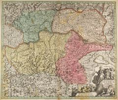
 BURGUND. - Karte. - Superior Burgundiae Comitatus vulgo La Franche Comte.
Altkol. Kupferstich von Valk, um 1710, 58 x 49 cm.
Mit allegorischer Titelkartusche rechts unten. (Artikelnr. 10186CG)
Erfahren Sie mehr170,00 € Inkl. MwSt.