Suchergebnisse für: "europa karte"
-
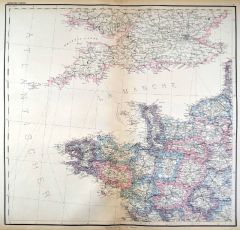 FRANKREICH. - Nordfrankreich. - Karte. - Nordwestliches Frankreich.
Kupferstich mit Farblithographie nach Kiepert, Weimar im Geograph. Institut, 1886, 54,5 x 57,5 cm.
Espenhorst, PP 1.1.6. - Aus: Heinrich Kiepert's "Grosser Hand-Atlas" (49. Ausgabe, Auflage 1886). - Zeigt die Küste von Boulogne bis St. Gi... (Artikelnr. 35161EG)
Erfahren Sie mehr90,00 € Inkl. MwSt. -
FRANKREICH. - Südfrankreich. - Karte. - Die Westalpen.
Farblithographie nach Scrobel aus Andree bei Velhagen & Klasing, 1893, 36 x 23 cm.
Espenhorst, PP 5.1.3. - Aus: Richard Andree's "Allgemeiner Handatlas" (3. Ausgabe, Auflage 1893). - Zeigt das Gebiet zwischen Genf im Norden und der Westlic... (Artikelnr. 35550EG)
Erfahren Sie mehr70,00 € Inkl. MwSt. -
SCHWEIZ. - Karte. - Die Schweiz. Gesamtkarte.
Grenzkol. Kupferstich von Kratz und Luther nach Gräf und Geyer, Weimar im Geograph. Institut, um 1860, 45,5 x 63,5 cm.
Espenhorst, PP 1.1.5. - Aus: Heinrich Kiepert's "Hand-Atlas" (42. Ausgabe, 1856/69). - Die 22 Kantone mit Grenzkolorit.... (Artikelnr. 35503EG)
Erfahren Sie mehr100,00 € Inkl. MwSt. -
SKANDINAVIEN. - Karte. - Schweden und Norwegen.
Grenzkol. Kupferstich nach Weiland, Weimar im Geograph. Institut, dat. 1830, 40 x 29 cm.
Espenhost, PP 1.2.2. - Aus dem verkleinerten "Hand-Atlas ... für Bürgerschulen und Zeitungsleser" (sog. Bund-Ausgabe). - Seltener ("greater rarity")... (Artikelnr. 33307EG)
Erfahren Sie mehr100,00 € Inkl. MwSt. -
43,00 € Inkl. MwSt.
-
57,00 € Inkl. MwSt.
-
 WALACHAI. - Karte. - Tabula Geographica continens Despotatus Wallachiae atque Moldaviae, Provinciam Bessarabiae.
Altkol. Kupferstich bei Homann Erben, dat. 1769, 47 x 50,5 cm. (Artikelnr. 24932CG)
Erfahren Sie mehr240,00 € Inkl. MwSt. -
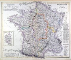 FRANKREICH. - Karte. - Frankreich. Gesamtkarte, mit Nebenkarte Corsica.
Grenzkol. Kupferstich nach Koehler aus Stein bei Hinrichs, 1857, 39,5 x 48,5 cm.
Espenhorst, PP 31.1.1.2. - Aus: C.G.D. Stein "Neuer Atlas der ganzen Erde" (29. Ausgabe, Auflage 1857). (Artikelnr. 34922EG)
Erfahren Sie mehr80,00 € Inkl. MwSt. -
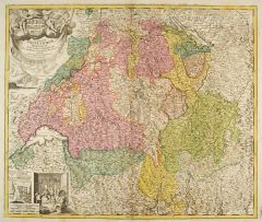 SCHWEIZ. - Karte. - Potentissimae Helvetiorum Reipublicae Cantones Tredecim.
Altkol. Kupferstich von Johann Baptist Homann, um 1720, 47,5 x 56 cm.
Schöne Gesamtkarte mit großer figürlicher und heraldischer Kartusche (mit den Wappen der Kantone und Städte), unten links Innenansicht einer Sennhütte. (Artikelnr. 5755CG)
Erfahren Sie mehr350,00 € Inkl. MwSt. -
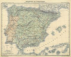 SPANIEN und PORTUGAL. - Karte. - Spanien und Portugal.
Farblithographie aus Adami-Kiepert bei Reimer, 1876, 25,5 x 33 cm.
Espenhorst, PP Anm. 27, S. 778. - Aus: Adami-Kiepert's "Schul-Atlas" (Ausgabe 1876). - Mit zwei Nebenkarten von Madeira und den Kanarischen Inseln. (Artikelnr. 19422BG)
Erfahren Sie mehr60,00 € Inkl. MwSt. -
SKANDINAVIEN. - Karte. - Schweden, Norwegen und Finland. Gesamtkarte.
Grenzkol. Kupferstich von Leutemann nach Koehler aus Stein bei Hinrichs, 1857, 49 x 40 cm.
Espenhorst, PP 31.1.1.2. - Aus: C.G.D. Stein "Neuer Atlas der ganzen Erde" (29. Ausgabe, Auflage 1857). (Artikelnr. 34924EG)
Erfahren Sie mehr90,00 € Inkl. MwSt. -
 ELSASS. - Karte. - Dep: des Oberrheins, des Doubs, der oberen Saone
Grenzkol. Lithographie bei Schlieben, 1829, 26 x 19 cm.
Gebietskarte zwischen Schlettstadt, Altkirch, Vesoul, Pontarlier. (Artikelnr. 18742AG)
Erfahren Sie mehr66,00 € Inkl. MwSt. -
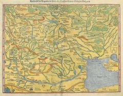
SCHWEIZ. - Karte. - Ury. Schweiz. Gesamtansichten von Altdorf und Schwyz nebeneinander.
Kol. Holzschnitt aus Seb. Münster, "Cosmographia", 1598, je 8 x 8 cm (auf der ganzen Buchseite). (Artikelnr. 15315AG)
Erfahren Sie mehr142,00 € Inkl. MwSt. -
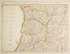 PORTUGAL. - Algarve. - Karte. - Carte des Royaumes de Portugal et d'Algarve.
Grenzkol. Kupferstich nach M. Rizzi-Zanoni, um 1760, 31 x 42 cm.
Mit Kopftitel und Privileg. (Artikelnr. 27400CG)
Erfahren Sie mehr150,00 € Inkl. MwSt. -
 SÜDOSTEUROPA. - Karte. - Landtafel des Ungerlandes / Polands / Reussen / Littaw / Walachei / Bulgarei.
Kol. Holzschnitt aus Seb. Münster, "Cosmographia", um 1580, 26 x 34 cm. (Artikelnr. 22757CG)
Erfahren Sie mehr260,00 € Inkl. MwSt. -
NIEDERLANDE. - Benelux. - Karte. - Niederlande und Belgien, mit Luxemburg.
Farblithographie aus Sohr-Berghaus bei Flemming, Glogau, um 1885, 33,5 x 27,5 cm.
Espenhorst, PP 4.1.3. - Aus: Sohr-Berghaus's "Hand-Atlas über alle Teile der Erde". (Artikelnr. 19478BG)
Erfahren Sie mehr75,00 € Inkl. MwSt. -
 RUSSLAND. - Karte. - Russlands oder Moskoviens Nord-West-Theil.
Kupferstich von J. Stridbeck, um 1700, 17 x 23 cm.
Zeigt Russland dem Moscowischen Meer bis Moskau und von Stockholm bis Permawelick. Von Joh. Stridbeck signiert und mit Privileg. (Artikelnr. 22191CG)
Erfahren Sie mehr100,00 € Inkl. MwSt. -
 WIEN. - Karte. - Les Environs de Vienne En Autriche.
Kupferstich von Nicolas de Fer, dat. 1705, 17 x 51 cm.
Zeigt den Donaulauf von Krems bis Pressburg, im Süden mit Laxenburg. Am linken Rand hinterlegter Durchriß. (Artikelnr. 14440CG)
Erfahren Sie mehr114,00 € Inkl. MwSt. -
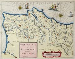 PORTUGAL. - Karte. - Portugallia et Algarbia que olim Lusitania.
Kol. Kupferstich von Gaspar Bouttats, um 1680, 33 x 42 cm.
Nicht genordete Gesamtkarte. Links unten Titelkartusche und Meilenzeiger. Links oben am Rand geringer Textabklatsch. (Artikelnr. 24736CG)
Erfahren Sie mehr200,00 € Inkl. MwSt. -
 PORTUGAL. - Karte. - Portvgallia et algarbia quae olim lvsitania.
Kupferstich nach A. Secco von Merian aus "Theatrum Europaeum", 1717, 28 x 36,5 cm.
Gesamtkarte mit Kartusche und zwei Wappen, im Meer Segelschiffe und Neptun. (Artikelnr. 18816CG)
Erfahren Sie mehr162,00 € Inkl. MwSt. -
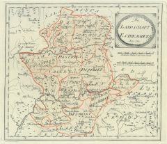 EXTREMADURA/Spanien. - Karte. - Die Landschaft Estremadura Nr. 550.
Altkol. Kupferstich von Reilly, um 1790, 23 x 26 cm.
Zeigt die im Südwesten des Landes gelegene, an Portugal grenzende Gemeinschaft mit den Provinzen Càceres und Badajoz. (Artikelnr. 24424CG)
Erfahren Sie mehr100,00 € Inkl. MwSt. -
 PORTUGAL. - Karte. - Portugallia et Algarbia que olim Lusitania.
Altkol. Kupferstich nach V.A. Secco bei Blaeu, um 1640, 38 x 50 cm.
Nicht genordete Gesamtkarte. Mit figürlicher Kartusche, 2 Wappen, Windrosen, Segelschiffen und Meeresgott. (Artikelnr. 2678GG)
Erfahren Sie mehr480,00 € Inkl. MwSt. -
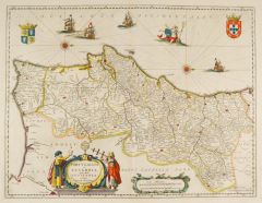
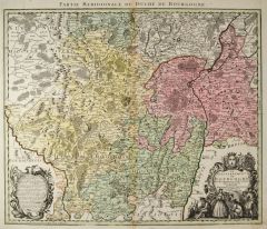 BOURGOGNE. - Karte. - Le Gouvernement de Bourgogne.
Altkol. Kupferstich von M. Seutter, um 1720, 48 x 57 cm.
Mit dem Kopftitel "Partie Meridionale du Duché de Bourgogne", großer, figürlicher Kartusche unten rechts und Kartusche mit Erklärungen unten links. - Mittelbug etwas gebräunt, s... (Artikelnr. 24695CG)
Erfahren Sie mehr180,00 € Inkl. MwSt. -
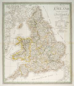 GROSSBRITANNIEN. - England. - Karte. - Gesamtkarte, mit Wales.
Grenzkol. Kupferstich nach Weiland, Weimar im Geograph. Institut, dat. 1836, 54 x 46,5 cm.
Espenhorst, PP 1.1.3. - Zeigt links die Irische Ostküste, rechts die Französische Küste von Calais bis Dieppe. - Rechts wasserrandig bis in die D... (Artikelnr. 660FG)
Erfahren Sie mehr108,00 € Inkl. MwSt. -
GROSSBRITANNIEN. - Karte. - Grosbritannien und Ireland. Gesamtkarte.
Grenzkol. Kupferstich nach Weiland, Weimar im Geograph. Institut, dat. 1830, 40 x 30,5 cm.
Espenhost, PP 1.2.2. - Aus dem verkleinerten "Hand-Atlas ... für Bürgerschulen und Zeitungsleser" (sog. Bund-Ausgabe). - Seltener ("greater rarity... (Artikelnr. 33301EG)
Erfahren Sie mehr110,00 € Inkl. MwSt. -
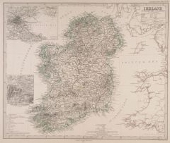
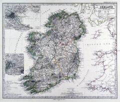 IRLAND. - Karte. - Ireland. Mit zwei Nebenkarten.
Grenzkol. Kupferstich von Poppey nach Petermann aus Stieler bei Perthes, Gotha, 1875, 33,5 x 40 cm.
Espenhorst, PP 2.1.1.1.6. - Aus: A. Stieler's "Hand-Atlas" (6. Ausgabe, Auflage 1875). - Die Nebenkarten zeigen: "Die Seen von Killarney" u... (Artikelnr. 35379EG)
Erfahren Sie mehr85,00 € Inkl. MwSt. -
SCHOTTLAND. - Karte. - Schottland. Mit zwei Nebenkarten.
Farblithographie nach Scrobel aus Andree bei Velhagen & Klasing, 1893, 47,5 x 36,5 cm.
Espenhorst, PP 5.1.3. - Aus: Richard Andree's "Allgemeiner Handatlas" (3. Ausgabe, Auflage 1893). - Die Nebenkarten zeigen die "Orkney Islands" und die ... (Artikelnr. 34944EG)
Erfahren Sie mehr90,00 € Inkl. MwSt. -
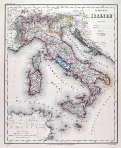 ITALIEN. - Karte. - Das Koenigreich Italien. Gesamtkarte.
Grenzkol. Stahlstich nach Radefeld auch Meyer bei BI, um 1868, 37 x 29,5 cm.
Espenhorst, PP 3.4 (Meyer-Ravenstein 1862-1884). - Aus: Joseph Meyer's "Hand-Atlas", redigiert von Ludwig Ravenstein (1838-1915). - Zeigt im Osten die Dalmatinisc... (Artikelnr. 32942EG)
Erfahren Sie mehr120,00 € Inkl. MwSt. -
SCHWEIZ. - Karte. - Die Schweiz, mit Nebenkarte.
Grenzkol. Kupferstich von Metzeroth nach Stülpnagel aus Stieler bei Perthes, Gotha, dat. 1852, 31 x 41 cm.
Espenhorst, PP 2.1.1.1.2. - Aus: A. Stieler's "Hand-Atlas" ("Second Edition"). - Die Nebenkarte zeigt das Unterengadin. - Oben ein ... (Artikelnr. 33232EG)
Erfahren Sie mehr85,00 € Inkl. MwSt. -
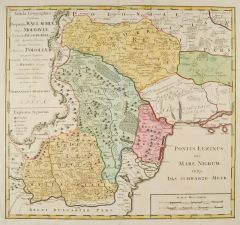
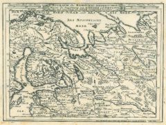
SÜDOSTEUROPA. - Karte. - Ungarn mit angrenzenden Ländern.
Kupferstich, um 1700, 14 x 21,5 cm.
Zeigt das Gebiet zwischen den Flüssen Theiß, Donau, Drau und Sann und zwischen den Städten Wien, Klausenburg, Griechisch-Weissenburg und Celje. - Links Legende mit einem Verzeichnis ungarischer König... (Artikelnr. 18921AG)
Erfahren Sie mehr104,00 € Inkl. MwSt. -
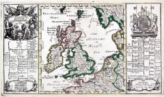 GROSSBRITANNIEN. - Karte. - Geographische Vorstellung der Königreiche Grosbrittannien und Irland.
Altkol. Kupferstich von Bodenehr, um 1720, 17 x 30 cm.
Die grenzkolorierte Gesamtkarte mit Kartusche, Wappen und Erklärungen links und rechts. Gerahmt. (Artikelnr. 4652CG)
Erfahren Sie mehr120,00 € Inkl. MwSt. -
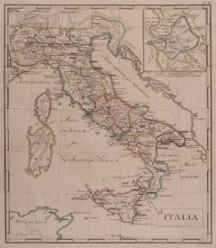 ITALIEN. - Karte. - Italia. Gesamtkarte mit Sizilien, Sardinien und Korsika.
Grenzkol. Kupferstich von W. Sander, Berlin, um 1825, 30 x 26 cm.
Mit kleiner Nebenkarte rechts oben. Alte Unterstreichungen von Ortsnamen. (Artikelnr. 19081CG)
Erfahren Sie mehr95,00 € Inkl. MwSt. -
ITALIEN. - Süditalien. - Karte. - Partie Septentrionale du Royaumes des Naples.
Grenzkol. Kupferstich bei Robert, 1748, 16 x 19 cm.
Zeigt das Gebiet von den Abruzzen bis zum Golf von Tarent. (Artikelnr. 18692AG)
Erfahren Sie mehr66,00 € Inkl. MwSt. -
DÄNEMARK. - Karte. - Charte des Königreichs Daenemark, im Süden bis einschließlich Lauenburg.
Altkol. Kupferstich bei Joh. Walch, Augsburg, um 1815, 18 x 21,5 cm. (Artikelnr. 31385EG)
Erfahren Sie mehr90,00 € Inkl. MwSt. -
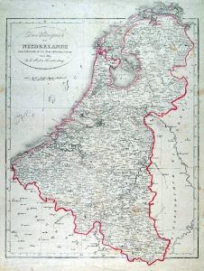 NIEDERLANDE. - Benelux. - Karte. - Das Königreich der Niederlande.
Grenzkol. Kupferstich bei J. Riedl, Wien, dat. 1819, 42,5 x 34 cm.
Zum Gebrauche der k.k. Österreichischen Schulen. Gesamtkarte mit Belgien und Luxemburg, oben links Inschrift. - Geglättete Längs- und Querfalte, geringe Gebrauchsspuren. (Artikelnr. 593FG)
Erfahren Sie mehr120,00 € Inkl. MwSt. -
 IRLAND. - Karte. - Ireland im Maassstabe 1:1.00.000.
Grenzkol. Kupferstich von Poppey und Jungmann nach Petermann aus Stieler bei Perthes, Gotha, dat. 1863, 33,5 x 40 cm.
Aus: A. Stieler's "Hand-Atlas". - Gesamtkarte mit Nebenkarte der Seen von Killarney und Umgebungsplan von Dublin. (Artikelnr. 7857CG)
Erfahren Sie mehr75,00 € Inkl. MwSt. -
RUSSLAND. - Karte. - Europaeisches Russland mit Polen. Gesamtkarte.
Farblithographie aus J.M. Ziegler bei J. Wurster, Winterthur, 1864, 53 x 44 cm.
Espenhorst, PP 65.1. - Aus: Jakob Melchior Ziegler's "Geographischer Atlas über alle Theile der Erde" (2. Auflage von 1864). - Leicht fleckig. (Artikelnr. 18992BG)
Erfahren Sie mehr160,00 € Inkl. MwSt. -
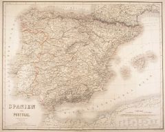 SPANIEN und PORTUGAL. - Karte. - Spanien und Portugal.
Grenzkol. Kupferstich von Dellinger und Biedermann nach Gräf, Weimar im Geograph. Institut, um 1860, 52,5 x 66 cm.
Espenhorst, PP 1.1.5. - Aus: Kiepert, "Hand-Atlas", 42. Ausgabe (1856/69). - Gesamtkarte einschließlich der Balearen. (Artikelnr. 17085AG)
Erfahren Sie mehr114,00 € Inkl. MwSt. -
FRANKREICH. - Nordfrankreich. - Karte. - Nordost-Frankreich.
Farblithographie nach Scrobel aus Andree bei Velhagen & Klasing, 1900, 36,5 x 49,5 cm.
Espenhorst, PP 5.1.4. - Aus: Richard Andree's "Allgemeiner Handatlas" (4. Ausgabe, Auflage 1900). - Zeigt im Westen das Gebiet ab der Linie Boulogne-Cha... (Artikelnr. 729FG)
Erfahren Sie mehr80,00 € Inkl. MwSt. -
FRANKREICH. - Ostfrankreich. - Karte. - Ost-Frankreich.
Farblithographie nach Scrobel aus Andree bei Velhagen & Klasing, 1900, 36,5 x 50,5 cm.
Espenhorst, PP 5.1.4. - Aus: Richard Andree's "Allgemeiner Handatlas" (4. Ausgabe, Auflage 1900). - Zeigt im Westen das Gebiet ab der Linie Orléans-Cha... (Artikelnr. 730FG)
Erfahren Sie mehr75,00 € Inkl. MwSt. -
52,00 € Inkl. MwSt.
-
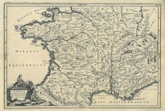
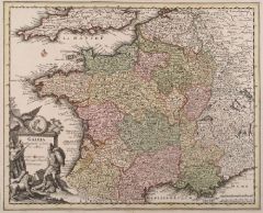 FRANKREICH. - Karte. - Gallia Cum Provinciis insertis et adsitis.
Altkol. Kupferstich bei Chr. Weigel, 1718, 27,5 x 34 cm.
Aus: Johann David Köhlers "Bequemer Schul= und Reisen=Atlas", 1718. - Gesamtkarte mit schöner Kartusche links unten. (Artikelnr. 3639CG)
Erfahren Sie mehr140,00 € Inkl. MwSt. -
NIEDERLANDE. - Benelux. - Karte. - Niederlande und Belgien, mit Luxemburg.
Grenzkol. Lithographie nach Handtke aus Sohr bei Flemming, Glogau, um 1850, 34 x 27,5 cm.
Espenhorst, PP 4.1.1. - Aus: Karl Sohr's "Vollständiger Universal=Handatlas der neueren Erdbeschreibung". (Artikelnr. 35234EG)
Erfahren Sie mehr85,00 € Inkl. MwSt. -
RUSSLAND. - Karte. - Das Europaeische Russland, bis zum Ural.
Grenzkol. Kupferstich von Maedel nach Weiland, Weimar im Geograph. Institut, dat. 1829, 56,5 x 45,5 cm.
Espenhorst, PP 1.1.2. - Zeigt Ostsee, Eismeer, Schwarzes und Kaspisches Meer. Mit Farberklärungen. (Artikelnr. 33046EG)
Erfahren Sie mehr148,00 € Inkl. MwSt. -
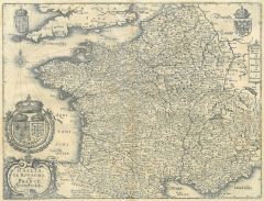 FRANKREICH. - Karte. - Gallia le Royavme de France. Franckreych. Gesamtkarte.
Kupferstich aus Gottfried, "Archontologia", 1649, 27 x 35,5 cm.
Mit dekorativer Wappenkartusche an den oberen Ecken Wappen. - Schönes, sauberes Exemplar. (Artikelnr. 15384AG)
Erfahren Sie mehr114,00 € Inkl. MwSt. -
 FRANKREICH. - Karte. - Gallia Narbonensis, Lugdunensis et Aquitania. Historische Gesamtkarte.
Kupferstich von J.G. Beck, 1773, 20,5 x 30,5 cm.
Aus: Christoph Cellarius, "Notitia orbis antiquii sive geographia plenior". - Mit figürlicher Kartusche. (Artikelnr. 19310CG)
Erfahren Sie mehr48,00 € Inkl. MwSt. -
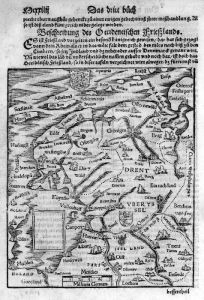 NIEDERLANDE. - Karte. - Beschreibung des Occidentischen Frießlands, oben das Wappen.
Holzschnitt aus Seb. Münster, "Cosmographia", 1590, 19,5 x 16,5 cm.
Zeigt das Gebiet zwischen Emden und Muijden. - Auf der vollen Buchseite. (Artikelnr. 33794EG)
Erfahren Sie mehr98,00 € Inkl. MwSt. -
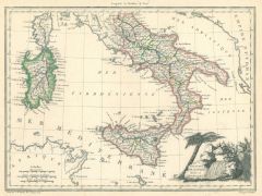 ITALIEN. - Süditalien. - Karte. - Royaumes de Naples, Sicile et Sardaigne.
Grenzkol. Kupferstich von J.B. Tardieu, um 1800, 22,5 x 30 cm.
Zeigt das südliche Italien von Elba bis Sizilien. Mit Titelkartusche rechts unten. (Artikelnr. 19706CG)
Erfahren Sie mehr95,00 € Inkl. MwSt. -
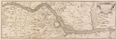
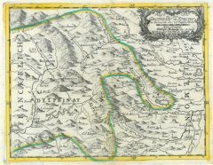 PINEROLO. - Karte. - Reyse Cart aus dem Delphinat in Italien.
Altkol. Kupferstich von Bodenehr, um 1720, 15 x 19,5 cm.
Zeigt die Umgegend von Pinerolo, im Westen bis Briancon und Embrun. - Breitrandig. (Artikelnr. 16979BG)
Erfahren Sie mehr110,00 € Inkl. MwSt. -
KYTHNOS. - Karte. - Divers ports sur l'isle de Termie. Küstenkarte.
Kol. Kupferstich von J. Roux, um 1800, 12,5 x 18,5 cm.
Betrifft "Port Colonne, Port fichada, Port du Millieu, Port Piscopia, Port America, Puits". (Artikelnr. 18868AG)
Erfahren Sie mehr48,00 € Inkl. MwSt.