Suchergebnisse für: "europa karte"
-
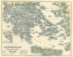
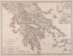 GRIECHENLAND. - Karte. - Griechenland und die Ionischen Inseln.
Grenzkol. Kupferstich von Eulenstein und Kratz aus Stieler bei Perthes, Gotha, dat. 1857, 31,5 x 41,5 cm.
Aus: A. Stieler's "Hand-Atlas". - Mit Plan der Gegend zwischen Athen und Piraeus sowie Stadtplan von Athen. Mit gestochener "Eintheil... (Artikelnr. 18034CG)
Erfahren Sie mehr95,00 € Inkl. MwSt. -
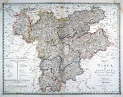 TIROL. - Karte. - Charte von Tirol und Vorarlberg.
Grenzkol. Kupferstich nach Streit, Weimar im Geograph. Institut, dat. 1822, 47 x 60,5 cm.
Espenhorst, PP 1.1.2. - Zeigt Nord- und Südtirol bis zum Gardasee, Vorarlberg und den östlichen Bodensee. - In den Ecken wasserrandig bis in den Zi... (Artikelnr. 33034EG)
Erfahren Sie mehr112,00 € Inkl. MwSt. -
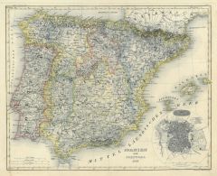
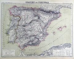 SPANIEN und PORTUGAL. - Karte. - Spanien und Portugal.
Grenzkol. Kupferstich von Dettmers und Sulzer aus Kiepert bei Reimer, Berlin, 1858, 44 x 56 cm.
Espenhorst, PP 20.1.1. - Aus: Heinrich Kiepert's "Neuer Handatlas über alle Theile der Erde" (Ausgabe 1858). - Schöne Gesamtkarte mit den Bal... (Artikelnr. 19021BG)
Erfahren Sie mehr100,00 € Inkl. MwSt. -
SPANIEN und PORTUGAL. - Karte. - Spanien und Portugal.
Grenzkol. Kupferstich von Dettmers und Sulzer aus Kiepert bei Reimer, Berlin, 1861, 44 x 56 cm.
Espenhorst, PP 20.1.1. - Aus: Heinrich Kiepert's "Neuer Handatlas über alle Theile der Erde" (Ausgabe 1861). - Schöne Gesamtkarte mit den Bal... (Artikelnr. 19139BG)
Erfahren Sie mehr100,00 € Inkl. MwSt. -
NORDPOL. - Karte. - Nordpolargebiete. Nordpolarregion, mit vier Nebenkarten.
Farblithographie nach Scrobel aus Andree bei Velhagen & Klasing, 1893, 36,5 x 46,5 cm.
Espenhorst, PP 5.1.3. - Aus: Richard Andree's "Allgemeiner Handatlas" (3. Ausgabe, Auflage 1893). - Die Nebenkarten zeigen Nowaja Semlja, Südwest-Grön... (Artikelnr. 35535EG)
Erfahren Sie mehr120,00 € Inkl. MwSt. -
 GRIECHENLAND. - Karte. - Griechenland, die Ionischen Inseln und Candia 1852 mit Nebenkarte Korfu.
Grenzkol. Stahlstich von Jean Adam aus Meyer's Zeitungsatlas, 1853, 20 x 25 cm. (Artikelnr. 1036BG)
Erfahren Sie mehr45,00 € Inkl. MwSt. -
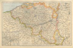 BELGIEN. - Karte. - Belgien. Mit Nebenkarte "Umgebung v. Charleroi".
Farblithographie nach Scrobel aus Andree bei Velhagen & Klasing, 1893, 23,5 x 36,5 cm.
Espenhorst, PP 5.1.3. - Aus: Richard Andree's "Allgemeiner Handatlas" (3. Ausgabe, Auflage 1893). - Zeigt im Südosten Luxemburg. (Artikelnr. 35547EG)
Erfahren Sie mehr60,00 € Inkl. MwSt. -
GRIECHENLAND. - Karte. - Griechenland. Mit Nebenkarte "Kreta oder Kandia".
Farblithographie nach Scrobel aus Andree bei Velhagen & Klasing, 1893, 23 x 36 cm.
Espenhorst, PP 5.1.3. - Aus: Richard Andree's "Allgemeiner Handatlas" (3. Ausgabe, Auflage 1893). - Zeigt im Norden Korfu und den Olymp. (Artikelnr. 35553EG)
Erfahren Sie mehr75,00 € Inkl. MwSt. -
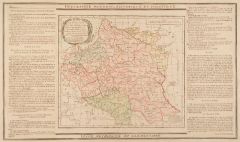 POLEN. - Karte. - Etats de Pologne et de Lithuanie.
Altkol. Kupferstich von Brion de la Tour, 1790, 23 x 26 cm, mit Legende 28 x 48 cm.
Gesamtkarte mit Lithauen. Beidseitig montierte Legende, die geographische, statistische und historische Besonderheiten beschreibt. Mit Kartusche. (Artikelnr. 7682AG)
Erfahren Sie mehr95,00 € Inkl. MwSt. -
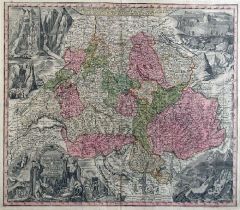 SCHWEIZ. - Karte. - Nova totius Helvetiae cum suis Subditis.
Altkol. Kupferstich bei Seutter, um 1742, 49 x 57 cm.
Dekorative Gesamtkarte der Schweiz, unten links große figürliche Titelkartusche, in den anderen Ecken große Ansichten mit Berglandschaften. - Unten hinterlegter Randeinriss. Gerahmt. (Artikelnr. 9816AG)
Erfahren Sie mehr450,00 € Inkl. MwSt. -
SCHWEIZ. - Karte. - Die Schweiz. Gesamtkarte, mit Anschlußkarte Unterengadin.
Grenzkol. Kupferstich von Metzeroth nach Stülpnagel aus Stieler bei Perthes, Gotha, 1866, 31 x 41 cm.
Espenhorst, PP 2.1.1.1.4. - Aus: A. Stieler's "Hand-Atlas" (4. Ausgabe, Auflage 1866). - Mittelbug verso verstärkt. (Artikelnr. 34902EG)
Erfahren Sie mehr70,00 € Inkl. MwSt. -
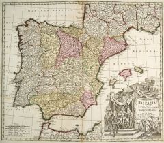 SPANIEN. - Karte. - Hispania ex Archetypo Roderici Mendez Sylvae.
Altkol. Kupferstich von G. de L'Isle bei Matthäus Seutter, um 1730, 50 x 57,5 cm.
Die schöne Gesamtkarte der iberischen Halbinsel zeigt auch die Balearen sowie die Nordküste Afrikas. Große figürliche Kartusche rechts unten. (Artikelnr. 27190CG)
Erfahren Sie mehr300,00 € Inkl. MwSt. -
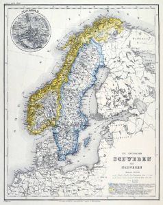 SKANDINAVIEN. - Karte. - Die Königreiche Schweden und Norwegen. Gesamtkarte.
Grenzkol. Stahlstich aus Meyer bei BI, um 1865, 37,5 x 29,5 cm.
Espenhorst, PP 3.4 (Meyer-Ravenstein 1862-1884). - Aus: Joseph Meyer's "Hand-Atlas", redigiert von Ludwig Ravenstein (1838-1915). - Mit einer kleinen Nebenkarte von Stockholm. (Artikelnr. 19269BG)
Erfahren Sie mehr120,00 € Inkl. MwSt. -
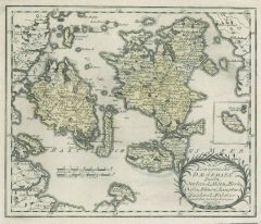
SCHOTTLAND. - Karte. - Schotland mit der Nördlichen Spitze von England.
Grenzkol. Kupferstich aus Stieler bei Perthes, Gotha, dat. 1824, 29 x 34 cm.
Espenhorst, PP 2.1.1.1.0.a. - Aus: A. Stieler's "Hand-Atlas" (Zero Edition). - Im Rand etwas fleckig. (Artikelnr. 33198EG)
Erfahren Sie mehr75,00 € Inkl. MwSt. -
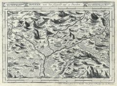 BOZEN. - Karte. - Botzen mit der Gegend auf 2 Stund.
Kupferstich von J. Stridbeck, um 1700, 16,5 x 22,5 cm.
Umgebungskarte von Bozen. Mit herausragenden Gebäuden der eingezeichneten Orte. Von Joh. Stridbeck signiert und mit Privileg. (Artikelnr. 22071CG)
Erfahren Sie mehr180,00 € Inkl. MwSt. -
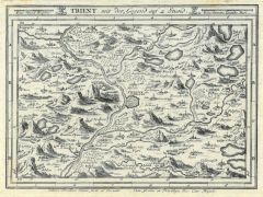 TRIENT. - Karte. - Trient mit der Gegend auf 2 Stund.
Kupferstich von J. Stridbeck, um 1700, 16,5 x 22,5 cm.
Umgebungskarte von Trient. Mit herausragenden Gebäuden der eingezeichneten Orte. Von Joh. Stridbeck signiert und mit Privileg. (Artikelnr. 22072CG)
Erfahren Sie mehr160,00 € Inkl. MwSt. -
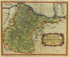 NIEDERÖSTERREICH. - Karte. - Primus Quadrans Erstes Viertl Unter Wienner Wald.
Altkol. Kupferstich von Seb. Insprugger bei M.T. Voigtin Wwe., Wien, um 1728, 13,5 x 16,5 cm.
Im Norden die Donau von Tuln bis Preßburg, im Süden Manigkirchen. (Artikelnr. 36137EG)
Erfahren Sie mehr180,00 € Inkl. MwSt. -
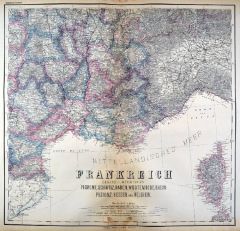
FRANKREICH. - Karte. - Frankreich. Gesamtkarte, mit Korsika.
Grenzkol. Kupferstich von Ohmann und Dellinger nach Gräf und Müller, Weimar im Geograph. Institut, 1872, 56,5 x 63,5 cm.
Espenhorst, PP 1.1.6. - Aus: Heinrich Kiepert's "Grosser Hand-Atlas" (43. Ausgabe, Auflage 1872). - Gewann 1871 die ... (Artikelnr. 35460EG)
Erfahren Sie mehr100,00 € Inkl. MwSt. -
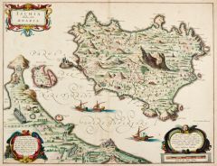 ISCHIA. - Karte. - Ischia Isola, olim Aenaria.
Altkol. Kupferstich von Joh. & Corn. Blaeu, um 1640, 38 x 49,5 cm.
Schöne und seltene Gesamtkarte mit der Isola di Procida, der Meerenge und dem Festland bei Miseno. Die Städte und wichtige Bauwerke wie Triumphbögen, Festungen, Türme u... (Artikelnr. 20723CG)
Erfahren Sie mehr500,00 € Inkl. MwSt. -
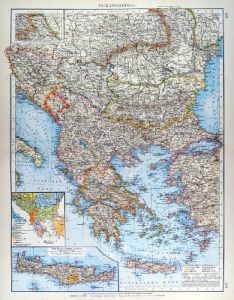 BALKAN. - Karte. - Balkanhalbinsel. Mit zwei Nebenkarten.
Farblithographie nach Scrobel aus Andree bei Velhagen & Klasing, 1900, 49,50 x 38 cm.
Espenhorst, PP 5.1.4. - Aus: Richard Andree's "Allgemeiner Handatlas" (4. Ausgabe, Auflage 1900). - Zeigt Griechenland, die Ägäis und die westliche Tü... (Artikelnr. 741FG)
Erfahren Sie mehr120,00 € Inkl. MwSt. -
GRIECHENLAND. - Karte. - Griechenland. Mit vier Nebenkarten.
Farblithographie nach Scrobel aus Andree bei Velhagen & Klasing, 1900, 38,5 x 49,50 cm.
Espenhorst, PP 5.1.4. - Aus: Richard Andree's "Allgemeiner Handatlas" (4. Ausgabe, Auflage 1900). - Zeigt im Norden Korfu und den Olymp. Die Nebenkarte... (Artikelnr. 740FG)
Erfahren Sie mehr130,00 € Inkl. MwSt. -
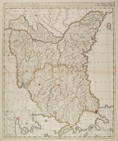
 BANAT. - Karte. - Die Banat oder ungarische Grenze nebst dem Tschaikistenbataillon.
Grenzkol. Lithographie bei Schlieben, 1829, 19,5 x 26 cm.
Zeigt das Gebiet nördlich der Donau von Peterwardein bis zur Walachei, im Mittelpunkt Weisskirchen. (Artikelnr. 18165CG)
Erfahren Sie mehr52,00 € Inkl. MwSt. -
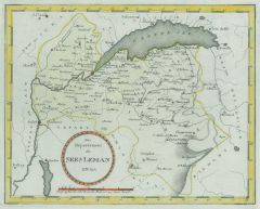 GENFER SEE. - Karte. - Das Departement des Sees Leman Nro. 823.
Altkol. Kupferstich von Reilly, um 1800, 21 x 26 cm.
Zeigt den See und das Gebiet südlich davon bis Chatillon, Nicholas und Chamouny. (Artikelnr. 24392CG)
Erfahren Sie mehr120,00 € Inkl. MwSt. -
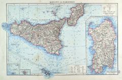 SIZILIEN. - Karte. - Sizilien und Sardinien.
Farblithographie nach Scrobel aus Andree bei Velhagen & Klasing, 1899, 23 x 36 cm.
Espenhorst, PP 5.1.4. - Aus: Richard Andree's "Allgemeiner Handatlas" (4. Ausgabe, Auflage 1899). - "Mit dieser Ausgabe wurde der ANDREE zum führenden deut... (Artikelnr. 35023EG)
Erfahren Sie mehr80,00 € Inkl. MwSt. -
SKANDINAVIEN. - Karte. - Schweden und Norwegen.
Grenzkol. Kupferstich von Wibel und Haubold nach Gräf, Weimar im Geograph. Institut, 1872, 67 x 51,5 cm.
Espenhorst, PP 1.1.6. - Aus: Heinrich Kiepert's "Grosser Hand-Atlas" (43. Ausgabe, Auflage 1872). - Gewann 1871 die einzige Goldmedai... (Artikelnr. 35468EG)
Erfahren Sie mehr110,00 € Inkl. MwSt. -
 KASTILIEN - La Mancha. - Karte. - Der Provinz La Mancha oestlicher Theil Nro. 564.
Altkol. Kupferstich von Reilly, um 1790, 24,5 x 27,5 cm. - Mit Nebenkarte. (Artikelnr. 24437CG)
Erfahren Sie mehr130,00 € Inkl. MwSt. -
 SPANIEN und PORTUGAL. - Karte. - Spanien und Portugal 1849 mit kleinem Plan von Madrid.
Grenzkol. Stahlstich aus Meyer's Zeitungsatlas, 1853, 21 x 27 cm. (Artikelnr. 933BG)
Erfahren Sie mehr38,00 € Inkl. MwSt. -
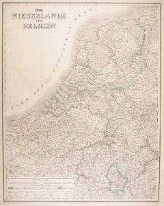 NIEDERLANDE. - Benelux. - Karte. - Die Niederlande und Belgien.
Grenzkol. Kupferstich von Eulenstein nach Gräf, Weimar im Geograph. Institut, dat. 1861, 66 x 52 cm.
Espenhorst, PP 1.1.5. - Aus: Kiepert, "Hand-Atlas", 42. Ausgabe (1856/69). - Gesamtkarte mit Maßstab und Erklärungen. Das Grenzkolorit... (Artikelnr. 126BG)
Erfahren Sie mehr76,00 € Inkl. MwSt. -
NIEDERLANDE. - Benelux. - Karte. - Niederland und Belgien. Gesamtkarte.
Farblithographie aus J.M. Ziegler bei J. Wurster, Winterthur, 1864, 55 x 41,5 cm.
Espenhorst, PP 65.1. - Aus: Jakob Melchior Ziegler's "Geographischer Atlas über alle Theile der Erde" (2. Auflage von 1864). - Zeigt Belgien, die Niederland... (Artikelnr. 18997BG)
Erfahren Sie mehr120,00 € Inkl. MwSt. -
GROSSBRITANNIEN. - England. - Karte. - England, Wales und Südschottland.
Farblithographie nach Wolf aus Spamer, 1902, 31,5 x 41,5 cm.
Espenhorst, PP 23.2. - Aus: O. Spamer's "Grosser Hand-Atlas" (2. Ausgabe, Auflage 1902). - Südschottland als Anschlußkarte, im Norden Inverness. Im Westen die Ostküste Irlands... (Artikelnr. 35091EG)
Erfahren Sie mehr85,00 € Inkl. MwSt. -
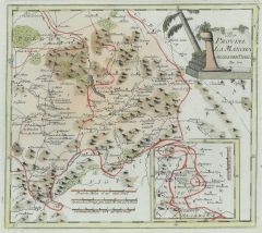
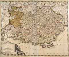 FRANKREICH. - Südfrankreich. - Karte. - Provincia ... Gouvernement de Provence.
Altkol. Kupferstich von G. Valck, um 1700, 49,5 x 60 cm.
Gesamtkarte der südfranzösischen Provinzen von Nizza bis zum Lauf der Rhone, im Norden bis Sisteron. Mit großer Kartusche links unten. - Mit schmalem Rand. Bugfalte hinterlegt. Gl... (Artikelnr. 27752CG)
Erfahren Sie mehr180,00 € Inkl. MwSt. -
 FRANKREICH. - Südfrankreich. - Karte. - Südöstliches Frankreich. Mit Korsika.
Kupferstich mit Farblithographie nach Kiepert, Weimar im Geograph. Institut, 1886, 54,5 x 57,5 cm.
Espenhorst, PP 1.1.6. - Aus: Heinrich Kiepert's "Grosser Hand-Atlas" (49. Ausgabe, Auflage 1886). - Zeigt die Küste von Barcelona bis Porto... (Artikelnr. 35163EG)
Erfahren Sie mehr90,00 € Inkl. MwSt. -
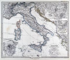 ITALIEN. - Karte. - Italien. Gesamtkarte, mit drei Nebenkarten.
Grenzkol. Kupferstich von Stier nach Petermann und Habenicht aus Stieler bei Perthes, Gotha, 1875, 33,5 x 40,5 cm.
Espenhorst, PP 2.1.1.1.6. - Aus: A. Stieler's "Hand-Atlas" (6. Ausgabe, Auflage 1875). - Die Nebenkarten zeigen: Turin, Rom ... (Artikelnr. 35368EG)
Erfahren Sie mehr85,00 € Inkl. MwSt. -
ITALIEN. - Süditalien. - Karte. - Italien, Südlicher Teil. Gebietskarte.
Farblithographie nach Wolf aus Spamer, 1902, 31,5 x 41,5 cm.
Espenhorst, PP 23.2. - Aus: O. Spamer's "Grosser Hand-Atlas" (2. Ausgabe, Auflage 1902). - Zeigt das Gebiet von Korsika - Toskana - Marken bis Hammamet in Tunesien. - Verso Typog... (Artikelnr. 35099EG)
Erfahren Sie mehr90,00 € Inkl. MwSt. -
GRIECHENLAND. - Karte. - Griechenland. Gesamtkarte, mit Nebenkarte (Inseln).
Altkol. Lithographie von E. Serth bei E. Hochdanz und C. Hoffmann, Stuttgart, 1875, 28 x 37,5 cm.
Espenhorst, PP 21.2.3; aus "Illustrirter Volks-Atlas", nach T. Brommes Handatlas hrg. v. C.G. Reuschle. - Die Nordgrenze verläuft vom Golf v... (Artikelnr. 32911EG)
Erfahren Sie mehr98,00 € Inkl. MwSt. -
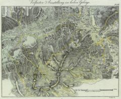
AUSTERLITZ. - Karte. - Kleinteilige Umgebungskarte, im Nordwesten Brünn.
Kupferstich von Jacobs nach Duvotenay aus Lavallée bei Furne, Paris, 1858, 14 x 20 cm.
Aus: Théophile Lavallée's "Atlas de Géographie Militaire". - Zeigt im Süden Groß Raigern, Mönitz und Milleschowitz, im Westen Medritz, im Norden ... (Artikelnr. 34871EG)
Erfahren Sie mehr65,00 € Inkl. MwSt. -
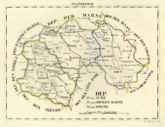 CHAMPAGNE. - Karte. - Dep: der Aube, der oberen Marne, der Yonne.
Grenzkol. Lithographie von Hermann bei Schlieben, 1829, 19 x 26 cm.
Mit Auxierre, Troyes, Bar sur Seine, Chaumont und Langres im Mittelpunkt. (Artikelnr. 18727AG)
Erfahren Sie mehr66,00 € Inkl. MwSt. -
 BULGARIEN und RUMÄNIEN. - Karte. - Bulgaria et Romania divisa in singulares.
Altkol. Kupferstich von Gerard & Leonard Valck, um 1700, 59 x 48 cm.
Große, grenzkolorierte Übersichtskarte mit Teilen von Nordgriechenland und der Türkei. - Gut erhalten. (Artikelnr. 988BG)
Erfahren Sie mehr300,00 € Inkl. MwSt. -
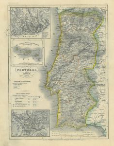 PORTUGAL. - Karte. - Portugal und die Azoren 1849, mit 3 Nebenkarten: Lissabon, Porto, Azoren.
Grenzkol. Stahlstich aus Meyer's Zeitungsatlas, 1853, 25 x 18 cm. (Artikelnr. 965BG)
Erfahren Sie mehr48,00 € Inkl. MwSt. -
70,00 € Inkl. MwSt.
-
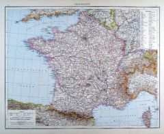 FRANKREICH. - Karte. - Frankreich. Gesamtkarte mit Korsika.
Farblithographie aus Andree bei Velhagen & Klasing, 1881, 37 x 47 cm.
Espenhorst, PP 5.1.1. - Aus: Richard Andree's "Allgemeiner Handatlas" (1. Ausgabe, Auflage 1881). - Mit Farbgrenzen für die 86 Departements. - Verso 3 weitere Darstellu... (Artikelnr. 35333EG)
Erfahren Sie mehr80,00 € Inkl. MwSt.