Suchergebnisse für: "europa karte"
-
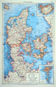 DÄNEMARK. - Karte. - Dänemark. Mit drei Nebenkarten.
Farblithographie nach Scrobel aus Andree bei Velhagen & Klasing, 1899, 36 x 23 cm.
Espenhorst, PP 5.1.4. - Aus: Richard Andree's "Allgemeiner Handatlas" (4. Ausgabe, Auflage 1899). - "Mit dieser Ausgabe wurde der ANDREE zum führenden deut... (Artikelnr. 35016EG)
Erfahren Sie mehr60,00 € Inkl. MwSt. -
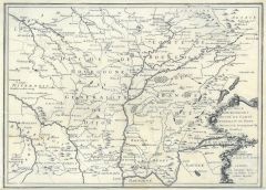 BOURGOGNE. - Karte. - Le deux Bourgognes Duché et Comté.
Kupferstich, Paris, 1705, 25 x 35 cm.
Gebietskarte zwischen Tonnerre und Befort im Norden, im Süden zwischen Riom, Trevoux und Genfer See, mittig der Saonelauf zwischen Lyon und Jonvelle. - Am Unterrand bis zum Bildrand beschnitten. (Artikelnr. 15083AG)
Erfahren Sie mehr86,00 € Inkl. MwSt. -
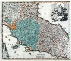 ITALIEN. - Mittelitalien. - Karte. - Tabula Etruriae, et Status Ecclesiast..
Altkol. Kupferstich von Mich. Kauffer bei Chr. Weigel, 1718, 32,5 x 39 cm.
Aus: Johann David Köhlers "Bequemer Schul= und Reisen=Atlas", 1718. - Zeigt das Gebiet zwischen Mantua und Fuciner See, mit der Insel Elba. Kartusche rechts oben. (Artikelnr. 18647BG)
Erfahren Sie mehr280,00 € Inkl. MwSt. -
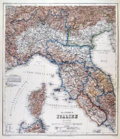 ITALIEN. - Norditalien. - Karte. - Das Koenigreich Italien. Nördliches Blatt.
Stahlstich mit Farblithographie nach Ravenstein auch Meyer bei BI, um 1865, 38 x 33 cm.
Espenhorst, PP 3.4 (Meyer-Ravenstein 1862-1884). - Aus: Joseph Meyer's "Hand-Atlas", redigiert von Ludwig Ravenstein (1838-1915). - Zeigt Norditalien m... (Artikelnr. 19296BG)
Erfahren Sie mehr140,00 € Inkl. MwSt. -
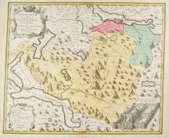 SCHWYZ. - Karte. - Canton Schweiz sive Pagus Helvetiae Suitensis.
Altkol. Kupferstich von Homann Erben, 1767, 48 x 53 cm.
Gesuchte Kantonskarte mit Wappenkartusche und einer Ansicht von Kloster Einsiedeln. Zeigt das Gebiet zwischen Zürich- und Vierwaldstätter See mit Zuger- und Luzerner See. - Stellenw... (Artikelnr. 27984CG)
Erfahren Sie mehr500,00 € Inkl. MwSt. -
DÄNEMARK. - Karte. - Daenemark mit Schleswig, Holstein u. Lauenburg.
Grenzkol. Kupferstich aus Stieler bei Perthes, Gotha, dat. 1850, 30 x 36,5 cm.
Espenhorst, PP 2.1.1.1.2. - Aus: A. Stieler's "Hand-Atlas" ("Second Edition"). - Mit 4 Nebenkarten von Hamburg, "Die Faer-Öer", Island, und Kopenhagen. - Im Ra... (Artikelnr. 33228EG)
Erfahren Sie mehr90,00 € Inkl. MwSt. -
SPANIEN und PORTUGAL. - Karte. - Spanien und Portugal. Gesamtkarte.
Altkol. Lithographie von E. Serth bei E. Hochdanz und C. Hoffmann, Stuttgart, 1875, 28,5 x 37 cm.
Espenhorst, PP 21.2.3; aus "Illustrirter Volks-Atlas", nach T. Brommes Handatlas hrg. v. C.G. Reuschle. - Im Süden die Nordafrikanische Küs... (Artikelnr. 32914EG)
Erfahren Sie mehr98,00 € Inkl. MwSt. -
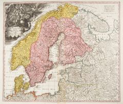 SKANDINAVIEN. - Karte. - Scandinavia complectens Sueciae, Daniae & Norvegiae Regna.
Altkol. Kupferstich von J.B. Homann, um 1730, 48 x 56 cm.
Gesamtkarte mit Dänemark, Finnland und dem gesamten Ostseeraum. Oben links große Kartusche mit figürlichen Allegorien und Porträtmedaillon. Mit Druckprivileg. - Im Bug etwas geb... (Artikelnr. 10103CG)
Erfahren Sie mehr300,00 € Inkl. MwSt. -
SKANDINAVIEN. - Karte. - Scandinavia complectens Sueciae, Daniae & Norvegiae Regna.
Altkol. Kupferstich von Mich. Kauffer bei Chr. Weigel, 1718, 33 x 38,5 cm.
Aus: Johann David Köhlers "Bequemer Schul= und Reisen=Atlas", 1718. - Gesamtkarte mit Dänemark, Finnland und dem gesamten Ostseeraum. Oben links Kartusche mit Por... (Artikelnr. 18652BG)
Erfahren Sie mehr220,00 € Inkl. MwSt. -
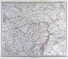
FRANKREICH. - Ostfrankreich. - Karte. - Ost-Frankreich.
Farblithographie von Kreutziger nach Mielisch aus Andree bei Velhagen & Klasing, 1899, 36,5 x 50,5 cm.
Espenhorst, PP 5.1.4. - Aus: Richard Andree's "Allgemeiner Handatlas" (4. Ausgabe, Auflage 1899). - "Mit dieser Ausgabe wurde der ANDREE... (Artikelnr. 35009EG)
Erfahren Sie mehr75,00 € Inkl. MwSt. -
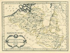
NIEDERLANDE. - Benelux. - Karte. - Die Niederlande und Belgien. Mit Luxemburg.
Farblithographie nach Wolf aus Spamer, 1902, 41,5 x 31,5 cm.
Espenhorst, PP 23.2. - Aus: O. Spamer's "Grosser Hand-Atlas" (2. Ausgabe, Auflage 1902). - Verso Typographie, mit 11 Gebietskarten. (Artikelnr. 35088EG)
Erfahren Sie mehr80,00 € Inkl. MwSt. -
NIEDERLANDE. - Benelux. - Karte. - Niederlande und Belgien. Gesamtkarte der Beneluxstaaten.
Grenzkol. Kupferstich von Herzberg und Sporer aus Kiepert bei Reimer, Berlin, 1861, 55 x 43,5 cm.
Espenhorst, PP 20.1.1. - Aus: Heinrich Kiepert's "Neuer Handatlas über alle Theile der Erde" (Ausgabe 1861). (Artikelnr. 19141BG)
Erfahren Sie mehr80,00 € Inkl. MwSt. -
 GALIZIEN. - Karte. - Allgemeine Charte der Koenigreiche Beider Galizien". Gesamtkarte.
Kupferstich nach J.M. Freiherr von Liechtenstern bei Kunst- und Industrie Comptoir, Wien, dat. 1804, 52 x 63 cm.
Bezeichnung und Erklärungen in Deutsch und Französisch. - Links oben fachmännisch ausgebesserter Einriß, mit geglätteten ... (Artikelnr. 2093GG)
Erfahren Sie mehr650,00 € Inkl. MwSt. -
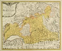 BERN. - Karte. - Canton Bern sive Illustris Helvetiorum Respublica Bernensis.
Alltkol. Kupferstich von S. Dorn nach G. Walser bei Homann Erben, dat. 1766, 47 x 56,5 cm.
Die gesuchte Kantonskarte mit dem Gebiet von Basel bis Luzern und dem Genfer See. (Artikelnr. 27275CG)
Erfahren Sie mehr400,00 € Inkl. MwSt. -
SKANDINAVIEN. - Karte. - Schweden und Norwegen. Mit Umgebungskarte von Stockholm.
Grenzkol. Kupferstich von Maedel nach Weiland, Weimar im Geograph. Institut, dat. 1842, 61 x 44 cm.
Espenhorst, PP 1.1.3. - Zeigt unten Dänemark bis Flensburg, rechts die Finnische Küste. - Rechts gering wasserrandig. (Artikelnr. 666FG)
Erfahren Sie mehr108,00 € Inkl. MwSt. -
SKANDINAVIEN. - Karte. - Schweden und Norwegen. Mit Umgebungskarte von Stockholm.
Grenzkol. Kupferstich von Maedel nach Weiland, Weimar im Geograph. Institut, dat. 1857, 61 x 45 cm.
Espenhorst, PP 1.1.5. - Zeigt im Süden Dänemark bis Flensburg, im Osten die Finnische Küste. (Artikelnr. 33161EG)
Erfahren Sie mehr112,00 € Inkl. MwSt. -
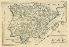 SPANIEN und PORTUGAL. - Karte. - Das Alte Spanien. Historische Gesamtkarte der Iberischen Halbinsel.
Kupferstich, Halle, um 1760, 19,5 x 29 cm.
Aus "Übersetzung der Allgemeinen Welthistorie". - Geglättete Längsfalten. (Artikelnr. 18791BG)
Erfahren Sie mehr88,00 € Inkl. MwSt. -
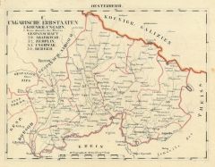
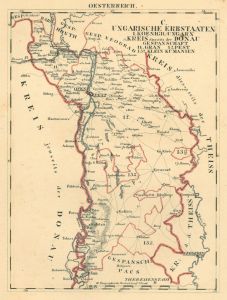
UNGARN. - Karte. - Kreis diesseits der Donau, Gespannschaft Gran, Pest und Klein Kumanien.
Grenzkol. Lithographie bei Schlieben, 1829, 26 x 19,5 cm.
Gebietskarte um Budapest von Gran bis Baja. (Artikelnr. 13963CG)
Erfahren Sie mehr62,00 € Inkl. MwSt. -
BALKAN. - Karte. - Balkanhalblinsel. Gesamtkarte mit Kreta. Mit Anschlußkarte "Moldau" (Nordrumänien).
Farblithographie nach Scrobel aus Andree bei Velhagen & Klasing, 1893, 47 x 37 cm.
Espenhorst, PP 5.1.3. - Aus: Richard Andree's "Allgemeiner Handatlas" (3. Ausgabe, Auflage 1893). (Artikelnr. 35554EG)
Erfahren Sie mehr100,00 € Inkl. MwSt. -
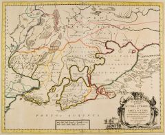 UKRAINE. - Karte. - Cimmeria quae Postea Scythia Europaea seu Parva Scythia.
Grenzkol. Kupferstich von P. Mortier nach G. Sanson, um 1705, 41 x 49 cm.
Zeigt das Gebiet nördlich des Schwarzen Meers. - Große figürliche Titelkartusche rechts unten. (Artikelnr. 27679CG)
Erfahren Sie mehr280,00 € Inkl. MwSt. -
BÖHMEN. - Mähren und Schlesien. - Karte. - Böhmen, Mähren und Österreichisch-Schlesien.
Farblithographie nach Scrobel aus Andree bei Velhagen & Klasing, 1893, 36,5 x 49 cm.
Espenhorst, PP 5.1.3. - Aus: Richard Andree's "Allgemeiner Handatlas" (3. Ausgabe, Auflage 1893). - (Artikelnr. 35542EG)
Erfahren Sie mehr90,00 € Inkl. MwSt. -
BÖHMEN. - Mähren und Schlesien. - Karte. - Böhmen, Mähren und Österreichisch-Schlesien.
Farblithographie nach Scrobel aus Andree bei Velhagen & Klasing, 1900, 36,5 x 49 cm.
Espenhorst, PP 5.1.4. - Aus: Richard Andree's "Allgemeiner Handatlas" (4. Ausgabe, Auflage 1900). (Artikelnr. 721FG)
Erfahren Sie mehr90,00 € Inkl. MwSt. -
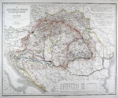 UNGARN. - Karte. - Das Königreich Ungarn mit seinen Nebenländern und Galizien.
Grenzkol. Kupferstich nach Gräf, Weimar im Geograph. Institut, um 1860, 51,5 x 64 cm.
Gesamtkarte mit dem Gebiet bis zur Adria (Slowenien, Kroatien, Dalmatien und Montenegro). (Artikelnr. 18431BG)
Erfahren Sie mehr140,00 € Inkl. MwSt. -
UNGARN. - Karte. - Ungarn und Galizien. Mit Nebenkarte "Budapest und Umgebung".
Farblithographie nach Scrobel aus Andree bei Velhagen & Klasing, 1900, 38 x 49 cm.
Espenhorst, PP 5.1.4. - Aus: Richard Andree's "Allgemeiner Handatlas" (4. Ausgabe, Auflage 1900). (Artikelnr. 722FG)
Erfahren Sie mehr100,00 € Inkl. MwSt. -
UNGARN. - Karte. - Ungarn und Galizien. Mit Nebenkarte "Budapest und Umgebung".
Farblithographie nach Scrobel aus Andree bei Velhagen & Klasing, 1893, 38 x 49 cm.
Espenhorst, PP 5.1.3. - Aus: Richard Andree's "Allgemeiner Handatlas" (3. Ausgabe, Auflage 1893). (Artikelnr. 35543EG)
Erfahren Sie mehr95,00 € Inkl. MwSt. -
 BELGIEN. - Karte. - Der Burgundische Kreis oder die Oestreichischen Niederlande Nro. 169.
Grenzkol. Kupferstich von Reilly, um 1790, 19 x 23,5 cm.
Zeigt das Gebiet zwischen Ostende, Charlemont, Remich, Lüttich, Wachtendonk. (Artikelnr. 17765AG)
Erfahren Sie mehr60,00 € Inkl. MwSt. -
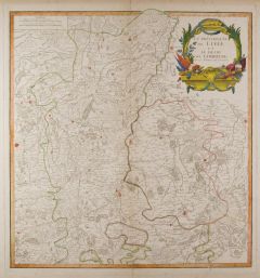 LÜTTICH. - Karte. - La Principaute de Liége et le Duché de Limbourg.
Grenzkol. Kupferstich von Robert de Vaugondy, 1754, 48 x 45 cm.
Zeigt das Gebiet bis Aachen und Jülich! - Mittelbug. (Artikelnr. 4859CG)
Erfahren Sie mehr150,00 € Inkl. MwSt. -
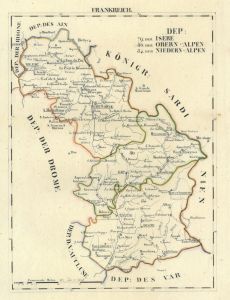 GRENOBLE. - Karte. - Dep: der Isere, der Obern - Alpen, der Nieder - Alpen.
Grenzkol. Lithographie bei Schlieben, 1829, 26 x 19 cm.
Gebietskarte zwischen Vienne, Grenoble, Gap und Digne. (Artikelnr. 18737AG)
Erfahren Sie mehr62,00 € Inkl. MwSt. -
 GRIECHENLAND. - Thrakien. - Karte. - Thracia antiqua. Gesamtkarte zur Zeit des Kaisers Augustus.
Kupferstich von J.G. Beck, 1773, 20,5 x 30,5 cm.
Aus: Christoph Cellarius, "Notitia orbis antiquii sive geographia plenior". - Mit figürlicher Kartusche. (Artikelnr. 19316CG)
Erfahren Sie mehr75,00 € Inkl. MwSt. -
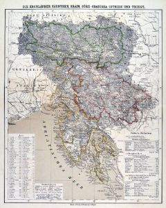 SLOWENIEN. - Karte. - Die Kronländer Kärnthen, Krain, Görz-Gradiska-Istrien und Triest.
Farblithographie aus Sohr-Berghaus bei Flemming, Glogau, um 1885, 41 x 33 cm.
Espenhorst, PP 4.1.3. - Aus: Sohr-Berghaus's "Hand-Atlas über alle Teile der Erde". (Artikelnr. 19461BG)
Erfahren Sie mehr80,00 € Inkl. MwSt. -
 KORSIKA. - Karte. - Die Insul Corsica mit dessen Districten und Aemtern abgetheilet.
Altkol. Kupferstich bei J.Ch. Schreiber, um 1730, 17 x 23 cm.
Schöne Gesamtkarte. Mit kleiner Kartusche, Legende links und rechts. (Artikelnr. 5980AG)
Erfahren Sie mehr140,00 € Inkl. MwSt. -
ARCOLE/bei Verona. - Karte. - Arcole. Kleinteilige Umgebungskarte.
Kupferstich von Dyonnet nach Duvotenay aus Lavallée bei Furne, Paris, 1858, 20 x 26 cm.
Aus: Théophile Lavallée's "Atlas de Géographie Militaire". - Zeigt den Lauf der Adige und das Gebiet um die Stadt, bei der Napoleon 1796 die Öster... (Artikelnr. 34867EG)
Erfahren Sie mehr70,00 € Inkl. MwSt. -
CASTIGLIONE delle Stiviere. - Karte. - Castiglione. Kleinteilige Umgebungskarte.
Kupferstich von Dyonnet nach Duvotenay aus Lavallée bei Furne, Paris, 1858, 20 x 25,5 cm.
Aus: Théophile Lavallée's "Atlas de Géographie Militaire". - Zeigt das Gebiet um die Stadt (Partnerstadt von Leutkirch im Allgäu), im Nordosten ... (Artikelnr. 34866EG)
Erfahren Sie mehr80,00 € Inkl. MwSt. -
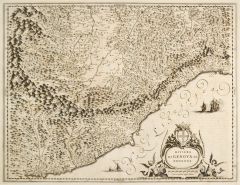 GENUA. - Karte. - Riviera di Genova da Ponente.
Kupferstich von W.J. Blaeu, um 1620, 39 x 50 cm.
Gebietskarte der Mittelmeerküste von Genua bis Nizza im Westen. Im Norden mit Piemont bis Turin reichend. - Mit großer, von zwei Nereiden gehaltenen Wappenkartusche der Republik Genua. Ver... (Artikelnr. 27321CG)
Erfahren Sie mehr450,00 € Inkl. MwSt. -
 RUSSLAND. - Karte. - Central-Russland. Gebietskarte mit Moskau.
Grenzkol. Kupferstich nach Petermann aus Stieler bei Perthes, Gotha, 1867, 33,5 x 40 cm.
Espenhorst, PP 2.1.1.1.6. - Aus: A. Stieler's "Hand-Atlas" (6. Ausgabe, Auflage 1875). - Zeigt das Gebiet um Moskau, im Norden die Gouvernements von N... (Artikelnr. 35384EG)
Erfahren Sie mehr85,00 € Inkl. MwSt. -
RUSSLAND. - Karte. - Central-Russland. Gebietskarte mit Moskau.
Grenzkol. Kupferstich nach Petermann aus Stieler bei Perthes, Gotha, 1867, 33,5 x 40 cm.
Espenhorst, PP 2.1.1.1.4. - Aus: A. Stieler's "Hand-Atlas" (4. Ausgabe, Auflage 1867). - Zeigt das Gebiet um Moskau, im Norden die Gouvernements von N... (Artikelnr. 34890EG)
Erfahren Sie mehr100,00 € Inkl. MwSt. -
RUSSLAND. - Karte. - Central-Russland. Gebietskarte mit Moskau.
Grenzkol. Kupferstich nach Petermann aus Stieler bei Perthes, Gotha, 1867, 33,5 x 40 cm.
Espenhorst, PP 2.1.1.1.4. - Aus: A. Stieler's "Hand-Atlas" (4. Ausgabe, Auflage 1867). - Zeigt das Gebiet um Moskau, im Norden die Gouvernements von N... (Artikelnr. 34889EG)
Erfahren Sie mehr100,00 € Inkl. MwSt. -
UKRAINE. - Karte. - Das Westliche Russland und Rumänien.
Farblithographie nach Wolf aus Spamer, 1902, 41,5 x 31,5 cm.
Espenhorst, PP 23.2. - Aus: O. Spamer's "Grosser Hand-Atlas" (2. Ausgabe, Auflage 1902). - Zeigt das Gebiet von St. Petersburg bis zur Krim, im Westen die Deutsche Grenze, im Ost... (Artikelnr. 35103EG)
Erfahren Sie mehr90,00 € Inkl. MwSt. -
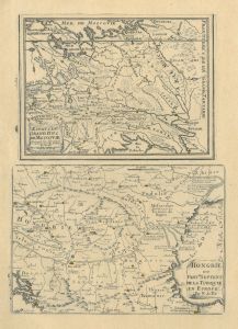 RUSSLAND. - Karte. - Estats du Grand Duc de Moscovie und "Hongrie ou Partie Septent. de la Turquie en Europe". Zwei Karten auf einem Blatt.
2 Kupferstiche von Nicolas de Fer, um 1700, 28 x 20 cm.
Die Russlandkarte reicht vom Asowschen Meer im Süden bis zum Weißen Meer im Norden. Die Ungarnkarte reicht von Wien bis Constantinopel. - Mit dem Textblatt. - Minimal gebräunt. (Artikelnr. 2398GG)
Erfahren Sie mehr280,00 € Inkl. MwSt. -
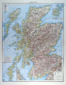 SCHOTTLAND. - Karte. - Schottland. Mit zwei Nebenkarten.
Farblithographie von Kehr nach Umbreit aus Andree bei Velhagen & Klasing, 1899, 47,5 x 38,5 cm.
Espenhorst, PP 5.1.4. - Aus: Richard Andree's "Allgemeiner Handatlas" (4. Ausgabe, Auflage 1899). - "Mit dieser Ausgabe wurde der ANDREE zum f?... (Artikelnr. 35014EG)
Erfahren Sie mehr90,00 € Inkl. MwSt. -
FRANKREICH. - Nordfrankreich. - Karte. - Nordost-Frankreich.
Farblithographie von Endlich nach Mielisch aus Andree bei Velhagen & Klasing, 1899, 36,5 x 49,5 cm.
Espenhorst, PP 5.1.4. - Aus: Richard Andree's "Allgemeiner Handatlas" (4. Ausgabe, Auflage 1899). - "Mit dieser Ausgabe wurde der ANDREE zu... (Artikelnr. 35008EG)
Erfahren Sie mehr80,00 € Inkl. MwSt. -
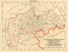
 BUDAPEST. - Karte. - Kreis diesseits der Donau, Gespannschaft Gran, Pest und Klein Kumanien.
Grenzkol. Lithographie bei Schlieben, 1829, 26 x 19,5 cm.
Zeigt das Gebiet östlich der Donau von Gran bis Theresienstadt. (Artikelnr. 18136CG)
Erfahren Sie mehr85,00 € Inkl. MwSt. -
ÖSTERREICH und UNGARN. - Karte. - Der Kaiserstaat Oesterreich. Gesamtkarte der Österreich-Ungarischen Monarchie.
Grenzkol. Stahlstich nach Radefeld aus Meyer bei BI, dat. 1851, 29,5 x 35,5 cm.
Espenhorst, PP 3.3. - Aus: "Meyer's Handatlas". (Artikelnr. 32951EG)
Erfahren Sie mehr110,00 € Inkl. MwSt. -
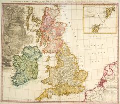 GROSSBRITANNIEN. - Karte. - Magna Britannia complectens Anglia, Scotiae et Hiberniae Regna.
Altkol. Kupferstich von Johann Baptist Homann, dat. 1749, 48,5 x 57 cm.
Gesamtkarte mit Irland, links oben große, dekorative Titelkartusche, rechts oben Nebenkarte der Shetland Inseln. Mit englischem Kopftitel. (Artikelnr. 27118CG)
Erfahren Sie mehr300,00 € Inkl. MwSt. -
SCHWEIZ. - Karte. - Die Schweiz. Gesamtkarte, mit Nebenkarte "Politische Übersicht" (Kantonseinteilung).
Farblithographie nach Scrobel aus Andree bei Velhagen & Klasing, 1900, 36,5 x 47,5 cm.
Espenhorst, PP 5.1.4. - Aus: Richard Andree's "Allgemeiner Handatlas" (4. Ausgabe, Auflage 1900). (Artikelnr. 724FG)
Erfahren Sie mehr80,00 € Inkl. MwSt. -
MÄHREN. - Karte. - Die Markgrafschaft Mähren nebst dem Oesterreichischen Herzogthum Schlesien.
Grenzkol. Kupferstich von Hensgen nach Weiland, Weimar im Geograph. Institut, dat. 1857, 41,5 x 58,5 cm.
Espenhorst, PP 1.1.5. - Mit Farberklärungen für die "Neueste politische Eintheilung". (Artikelnr. 33132EG)
Erfahren Sie mehr118,00 € Inkl. MwSt.