Suchergebnisse für: "europa karte"
-
FRANKREICH. - Karte. - Charte von Frankreich. Gesamtkarte, mit Korsika.
Grenzkol. Kupferstich nach Weiland, Weimar im Geograph. Institut, dat. 1828, 33 x 35 cm.
Espenhost, PP 1.2.2. - Aus dem verkleinerten "Hand-Atlas ... für Bürgerschulen und Zeitungsleser" (sog. Bund-Ausgabe). - Seltener ("greater rarity")... (Artikelnr. 33299EG)
Erfahren Sie mehr90,00 € Inkl. MwSt. -
 FRANKREICH. - Karte. - Frankreich, Südliche Hälfte, mit Nebenkarte "Corsica".
Farblithographie nach Scrobel aus Andree bei Velhagen & Klasing, 1893, 37 x 46 cm.
Espenhorst, PP 5.1.3. - Aus: Richard Andree's "Allgemeiner Handatlas" (3. Ausgabe, Auflage 1893). - Zeigt die Mittelmeerküste von Barcelona bis Ventimiglia... (Artikelnr. 34940EG)
Erfahren Sie mehr80,00 € Inkl. MwSt. -
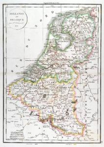 NIEDERLANDE. - Benelux. - Karte. - Hollande et Belgique, mit Luxemburg.
Grenzkol. Kupferstich aus Delamarche, dat. 1833, 41 x 29,5 cm.
Aus: Felix Delamarche's "Atlas de la Géographie ancienne, du moyen-age et moderne". - Der Ingenieur und Mechaniker für Erd- und Himmelsgloben übernahm 1811 das Atlantengesch... (Artikelnr. 34830EG)
Erfahren Sie mehr75,00 € Inkl. MwSt. -
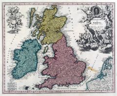 GROSSBRITANNIEN. - Karte. - Anglia, Scotia & Hibernia cum Insulis vicinis.
Altkol. Kupferstich bei Chr. Weigel, 1718, 27 x 34 cm.
Aus: Johann David Köhlers "Bequemer Schul= und Reisen=Atlas", 1718. - Gesamtkarte von Großbritannien und Irland, rechts oben mit dekorativer, allegorischer Kartusche und drei Wappen ... (Artikelnr. 18614BG)
Erfahren Sie mehr200,00 € Inkl. MwSt. -
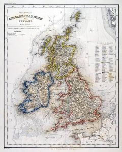 GROSSBRITANNIEN. - Karte. - Das Koenigreich Grossbritannien und Ireland. Gesamtkarte.
Grenzkol. Stahlstich aus Meyer bei BI, um 1865, 36,5 x 29,5 cm.
Espenhorst, PP 3.4 (Meyer-Ravenstein 1862-1884). - Aus: Joseph Meyer's "Hand-Atlas", redigiert von Ludwig Ravenstein (1838-1915). - Zeigt im Nordosten die Strömung vor der no... (Artikelnr. 32943EG)
Erfahren Sie mehr100,00 € Inkl. MwSt. -
GROSSBRITANNIEN. - Nordengland. - Karte. - England und Wales, Nördliche Hälfte.
Farblithographie nach Scrobel aus Andree bei Velhagen & Klasing, 1893, 36,5 x 50 cm.
Espenhorst, PP 5.1.3. - Aus: Richard Andree's "Allgemeiner Handatlas" (3. Ausgabe, Auflage 1893). - Zeigt das Gebiet von Glasgow im Norden bis zur Linie S... (Artikelnr. 34942EG)
Erfahren Sie mehr90,00 € Inkl. MwSt. -
GROSSBRITANNIEN. - Nordengland. - Karte. - England und Wales. Nördliche Hälfte.
Farblithographie nach Scrobel aus Andree bei Velhagen & Klasing, 1900, 36,5 x 49,5 cm.
Espenhorst, PP 5.1.4. - Aus: Richard Andree's "Allgemeiner Handatlas" (4. Ausgabe, Auflage 1900). - Zeigt das Gebiet ab Glasgow im Norden bis zur Linie ... (Artikelnr. 734FG)
Erfahren Sie mehr90,00 € Inkl. MwSt. -
GROSSBRITANNIEN. - Südengland. - Karte. - England und Wales, Südliche Hälfte.
Farblithographie nach Scrobel aus Andree bei Velhagen & Klasing, 1893, 36,5 x 50 cm.
Espenhorst, PP 5.1.3. - Aus: Richard Andree's "Allgemeiner Handatlas" (3. Ausgabe, Auflage 1893). - Zeigt das Gebiet ab der Linie Shrewsbury - Norwich im ... (Artikelnr. 34943EG)
Erfahren Sie mehr90,00 € Inkl. MwSt. -
GROSSBRITANNIEN. - Südengland. - Karte. - England und Wales. Südliche Hälfte.
Farblithographie nach Scrobel aus Andree bei Velhagen & Klasing, 1900, 37,5 x 49,5 cm.
Espenhorst, PP 5.1.4. - Aus: Richard Andree's "Allgemeiner Handatlas" (4. Ausgabe, Auflage 1900). - Zeigt im Norden das Gebiet ab der Linie Shrewsbury-N... (Artikelnr. 733FG)
Erfahren Sie mehr90,00 € Inkl. MwSt. -
SCHOTTLAND. - Karte. - Scotland. Mit Nebenkarte "Die Shetland Inseln".
Grenzkol. Kupferstich nach Weiland, Weimar im Geograph. Institut, dat. 1826, 33,5 x 29 cm.
Espenhost, PP 1.2.2. - Aus dem verkleinerten "Hand-Atlas ... für Bürgerschulen und Zeitungsleser" (sog. Bund-Ausgabe). - Seltener ("greater rarity... (Artikelnr. 33303EG)
Erfahren Sie mehr100,00 € Inkl. MwSt. -
 ITALIEN. - Kirchenstaat. - Karte. - Status Ecclesiastici Magnique Ducatus Florentini.
Altkol. Kupferstich von Johann Baptist Homann, um 1720, 49 x 57,5 cm.
Zeigt den Kirchenstaat und die Toskana bis Ferrara und Mantua im Norden, im Süden Gaeta reichend. Mit großer figürlicher Kartusche rechts oben. - Aufwendig in Echtsil... (Artikelnr. 23922CG)
Erfahren Sie mehr380,00 € Inkl. MwSt. -
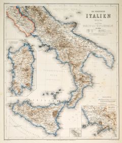 ITALIEN. - Süditalien. - Karte. - Das Koenigreich Italien. Südliches Blatt.
Stahlstich mit Farblithographie nach Ravenstein auch Meyer bei BI, um 1865, 38 x 33 cm.
Espenhorst, PP 3.4 (Meyer-Ravenstein 1862-1884). - Aus: Joseph Meyer's "Hand-Atlas", redigiert von Ludwig Ravenstein (1838-1915). - Zeigt Süditalien m... (Artikelnr. 19297BG)
Erfahren Sie mehr130,00 € Inkl. MwSt. -
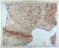
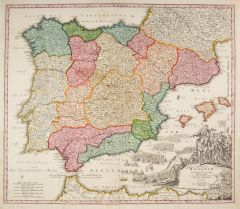 SPANIEN. - Karte. - Regnorum Hispaniae et Portugalliae Tabula Generalis.
Altkol. Kupferstich von Johann Baptist Homann, um 1720, 47,5 x 57,5 cm.
Die schöne, flächenkolorierte Gesamtkarte der iberischen Halbinsel zeigt auch die Balearen sowie die Nordküste Afrikas. Große figürliche Kartusche mit zahlreichen... (Artikelnr. 1439GG)
Erfahren Sie mehr290,00 € Inkl. MwSt. -
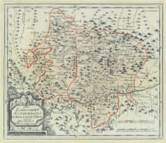
MÄHREN. - Karte. - Die Markgrafschaft Mähren nebst Oesterreichisch Schlesien.
Grenzkol. Kupferstich von Jungmann nach Weiland, Weimar im Geograph. Institut, dat. 1840, 41,5 x 58,5 cm.
Espenhorst, PP 1.1.3. - Mit Farberklärung für die Kreise: Olmütz, Brünn, Iglau, Znaim, Hradisch, Prerau, Troppau und Teschen. - U... (Artikelnr. 635FG)
Erfahren Sie mehr108,00 € Inkl. MwSt. -
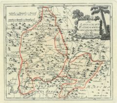
MÄHREN. - Karte. - Die Markgrafschaft Mähren nebst Oesterreichisch Schlesien.
Grenzkol. Kupferstich von Jungmann nach Weiland, Weimar im Geograph. Institut, dat. 1825, 42 x 58 cm.
Espenhorst, PP 1.1.2. - Mit Farberklärung für die Kreise: Olmütz, Brünn, Iglau, Znaim, Hradisch, Prerau, Troppau und Teschen. - In de... (Artikelnr. 33031EG)
Erfahren Sie mehr108,00 € Inkl. MwSt. -
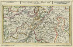 FORT LOUIS. - Karte. - Fort Luis mitt der Gegend auff 6 Stunden.
Altkol. Kupferstich bei Bodenehr, um 1720, 16 x 25,5 cm.
Grenzkolorierte Umgebungskarte mit Baden, der Grafschaft Eberstein und dem Oberamt Hagenau. (Artikelnr. 16144CG)
Erfahren Sie mehr95,00 € Inkl. MwSt. -
 BÖHMEN. - Karte. - Des Königreichs Böheim Kreise Bitschow und Königingraetz Nro. 98.
Grenzkol. Kupferstich von Reilly, um 1790, 20,5 x 28 cm.
Zeigt das Gebiet nördlich von Königgrätz mit Habelschwerd, Glatz, Wunschelberg, Trautnau und Landeshut. (Artikelnr. 24398CG)
Erfahren Sie mehr110,00 € Inkl. MwSt. -
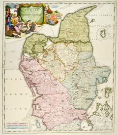 JÜTLAND. - Karte. - Tabula Generalis Jutiae continens ... Alburgensem, Wiburgensem, Ripensem et Arhusiensem.
Altkol. Kupferstich von J.B. Homann, um 1730, 58 x 49,5 cm.
Gesamtkarte der vier Herrschaften. Mit großer, altkolorierter figürlicher Titelkartusche links oben. (Artikelnr. 26282CG)
Erfahren Sie mehr280,00 € Inkl. MwSt. -
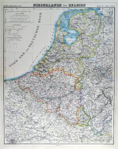
NIEDERLANDE. - Benelux. - Karte. - Niederlande und Belgien. Gesamtkarte der Beneluxstaaten.
Grenzkol. Kupferstich von Herzberg und Sporer aus Kiepert bei Reimer, Berlin, 1875, 55 x 43,5 cm.
Espenhorst, PP 20.1.2. - Aus: Heinrich Kiepert's "Neuer Handatlas über alle Theile der Erde" (Ausgabe 1875). - Berichtigt 1874. (Artikelnr. 19045BG)
Erfahren Sie mehr85,00 € Inkl. MwSt. -
 NIEDERLANDE. - Benelux. - Karte. - Niederlande und Belgien. Gesamtkarte der Beneluxstaaten.
Grenzkol. Kupferstich von Herzberg und Sporer aus Kiepert bei Reimer, Berlin, 1871, 55 x 43,5 cm.
Espenhorst, PP 20.1.2. - Aus: Heinrich Kiepert's "Neuer Handatlas über alle Theile der Erde" (Ausgabe 1871). - Berichtigt 1870. (Artikelnr. 19098BG)
Erfahren Sie mehr85,00 € Inkl. MwSt. -
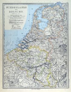 NIEDERLANDE. - Benelux. - Karte. - Niederlande und Belgien. Gesamtkarte der Beneluxstaaten.
Kupferstich mit Farblithographie nach Vogel aus Stieler bei Perthes, Gotha, 1891, 41,5 x 32,5 cm.
Espenhorst, PP 2.1.1.1.8. - Aus: A. Stieler's "Hand-Atlas" (8. Ausgabe, Auflage 1891). - Mit einer kleinen Nebenkarte von Antwerpen. (Artikelnr. 19180BG)
Erfahren Sie mehr70,00 € Inkl. MwSt. -
ITALIEN. - Karte. - Italiae Cum adjacentibus Insulis accurata consignatio Curante.
Altkol. Kupferstich von Mich. Kauffer bei Chr. Weigel, 1718, 27,5 x 34 cm.
Aus: Johann David Köhlers "Bequemer Schul= und Reisen=Atlas", 1718. - Schöne Gesamtkarte mit Sizilien, Sardinien und Korsika. Rechts oben Kartusche. Breitrandig. (Artikelnr. 18641BG)
Erfahren Sie mehr280,00 € Inkl. MwSt. -
ITALIEN. - Nord- und Mittelitalien. - Karte. - Ober- und Mittel-Italien.
Grenzkol. Kupferstich von Mädel/Weiler nach Kiepert, Weimar im Geograph. Institut, 1876, 51,5 x 62 cm.
Espenhorst, AS, 1.1.6. - Zeigt Italien von Brixen bis Terracina und Benevent. Mit Nebenkarte Rom und Umgebung, Titel, Maßstab und Erkl... (Artikelnr. 32599EG)
Erfahren Sie mehr128,00 € Inkl. MwSt. -
 MAILAND. - Karte. - Ducatus Mediolanensis Placentini et Parmensis nova Tabula.
Altkol. Kupferstich von Mich. Kauffer bei Chr. Weigel, 1718, 33,5 x 39,5 cm.
Aus: Johann David Köhlers "Bequemer Schul= und Reisen=Atlas", 1718. - Zeigt das nordwestliche Italien mit Mailand im Mittelpunkt und den oberitalienischen Seen. ... (Artikelnr. 18645BG)
Erfahren Sie mehr320,00 € Inkl. MwSt. -
RUSSLAND. - Karte. - Asiatisches Russland, vom Ural bis zur Behringstraße.
Grenzkol. Lithographie nach Handtke aus Sohr bei Flemming, Glogau, 1853, 30 x 41 cm.
Espenhorst, PP 4.1.1. - Aus: Karl Sohr's "Vollständiger Universal=Handatlas der neueren Erdbeschreibung". - Insgesamt etwas fleckig, wie meistens (PP S. ... (Artikelnr. 31941EG)
Erfahren Sie mehr80,00 € Inkl. MwSt. -
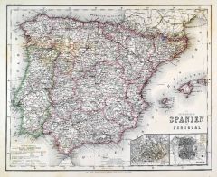 SPANIEN und PORTUGAL. - Karte. - Die Königreiche Spanien und Portugal.
Grenzkol. Stahlstich nach Radefeld aus Meyer bei BI, um 1865, 29,5 x 37 cm.
Espenhorst, PP 3.4 (Meyer-Ravenstein 1862-1884). - Aus: Joseph Meyer's "Hand-Atlas", redigiert von Ludwig Ravenstein (1838-1915). - Mit zwei Nebenkarten von Lissab... (Artikelnr. 19255BG)
Erfahren Sie mehr110,00 € Inkl. MwSt. -
SPANIEN und PORTUGAL. - Karte. - Spanien und Portugal, mit Balearen.
Farblithographie nach Scrobel aus Andree bei Velhagen & Klasing, 1893, 36,5 x 46,5 cm.
Espenhorst, PP 5.1.3. - Aus: Richard Andree's "Allgemeiner Handatlas" (3. Ausgabe, Auflage 1893). - Im Süden die Nordafrikanische Küste zwischen El Ar... (Artikelnr. 35549EG)
Erfahren Sie mehr110,00 € Inkl. MwSt. -
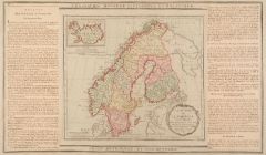 SKANDINAVIEN. - Karte. - La Suéde et la Norwége avec l'Island.
Altkol. Kupferstich von Brion de la Tour, 1790, 23 x 26 cm, mit Legende 28 x 48 cm.
Gesamtkarte mit kleiner Nebenkarte von Island. Beidseitig montierte Legende, die geographische, statistische und historische Besonderheiten beschreibt. - M... (Artikelnr. 7685AG)
Erfahren Sie mehr86,00 € Inkl. MwSt. -
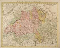 SCHWEIZ. - Karte. - Helvetia tredecim statibvs liebris qvos Cantones vocant.
Altkol. Kupferstich bei Homann Erben, dat. 1751, 43 x 55 cm.
Schöne Gesamtkarte mit großer figürlicher und heraldischer Kartusche (mit den Wappen der Kantone und Städte). - Im Bug fachmännisch restauriert, vor allem im Rand etwas flec... (Artikelnr. 2418GG)
Erfahren Sie mehr280,00 € Inkl. MwSt. -
FRANKREICH. - Südfrankreich. - Karte. - Frankreich, Generalkarte Nr. IV.
Grenzkol. Lithographie nach Handtke aus Sohr bei Flemming, Glogau, 1850, 32,5 x 38,5 cm.
Espenhorst, PP 4.1.1. - Aus: Karl Sohr's "Vollständiger Universal=Handatlas der neueren Erdbeschreibung". - Zeigt die Küstenlinie vom Golf von Rosas... (Artikelnr. 35237EG)
Erfahren Sie mehr80,00 € Inkl. MwSt. -
 FRANKREICH. - Südfrankreich. - Karte. - Südost-Frankreich. Mit Nebenkarte.
Farblithographie nach Scrobel aus Andree bei Velhagen & Klasing, 1900, 37 x 49,5 cm.
Espenhorst, PP 5.1.4. - Aus: Richard Andree's "Allgemeiner Handatlas" (4. Ausgabe, Auflage 1900). - Zeigt im Westen Toulouse, im Osten Mentone, im Norden ... (Artikelnr. 731FG)
Erfahren Sie mehr110,00 € Inkl. MwSt. -
SPANIEN und PORTUGAL. - Karte. - Spanien und Portugal.
Grenzkol. Kupferstich von Dettmers und Sulzer aus Kiepert bei Reimer, Berlin, 1875, 44 x 56 cm.
Espenhorst, PP 20.1.2. - Aus: Heinrich Kiepert's "Neuer Handatlas über alle Theile der Erde" (Ausgabe 1875). - Berichtigt 1874. - Schöne Gesa... (Artikelnr. 19043BG)
Erfahren Sie mehr110,00 € Inkl. MwSt. -
SPANIEN und PORTUGAL. - Karte. - Spanien und Portugal.
Grenzkol. Kupferstich von Ohmann und Sulzer aus Kiepert bei Reimer, Berlin, 1871, 44 x 56 cm.
Espenhorst, PP 20.1.2. - Aus: Heinrich Kiepert's "Neuer Handatlas über alle Theile der Erde" (Ausgabe 1871). - Berichtigt 1870. - Schöne Gesamt... (Artikelnr. 19095BG)
Erfahren Sie mehr110,00 € Inkl. MwSt. -
GROSSBRITANNIEN. - Karte. - Die Britischen Inseln.
Grenzkol. Farblithographie nach L. Ewald bei Jonghaus & Venator, Darmstadt, um 1865/68, 33,5 x 39,5 cm.
Neue Auflage, revidirt von Dr. F. Schäffer, 1860; oben rechts: "Ewald's Handatlas Nr. 60"; Espenhorst, PP 19.1.3. - "Der Darmstädter ... (Artikelnr. 34741EG)
Erfahren Sie mehr120,00 € Inkl. MwSt. -
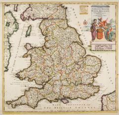 GROSSBRITANNIEN. - England. - Karte. - Accuratissima Angliae Regni et Walliae Principatus Descriptio.
Altkol. Kupferstich von Danckerts, um 1680, 51 x 53 cm.
Zeigt England mit der Küste von Irland. Mit großer, altkolorierter figürlicher Kartusche mit Wappenschild und Krone. - Ränder gering unfrisch. Schönes Altkolorit. (Artikelnr. 10145CG)
Erfahren Sie mehr240,00 € Inkl. MwSt. -
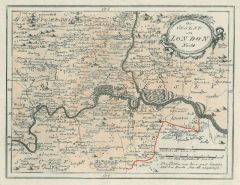
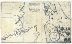 LONDON. - Karte. - Representationde la maniere Comment le A' de Ruyter.
Kupferstich, um 1650, insgesamt: 22,5 x 38 cm.
Zeigt den Themselauf von London bis zur Nordsee sowie die Küste mit Oxford und Colchester. Rechts Nebenkarte mit der Belagerung der Insel Queenborough. (Artikelnr. 15670BG)
Erfahren Sie mehr140,00 € Inkl. MwSt. -
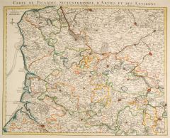 PICARDIE. - Karte. - Carte de Picardie Septentrionale d'Artois es des Environs.
Grenzkol. Kupferstich von Guillaume de l'Isle bei Covens & Mortier, um 1720, 48 x 61 cm.
Gebietskarte mit Kopftitel und kleinem Meilenzeiger. Zeigt die Picardie mit dem nördlichen Teil des Artois. (Artikelnr. 27324CG)
Erfahren Sie mehr200,00 € Inkl. MwSt. -
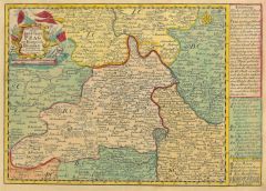
BÖHMEN. - Karte. - Das Königreich Böhmen. Mit drei Umgebungskarten: Karlsbad, Teplitz und Prag.
Grenzkol. Kupferstich nach Weiland, Weimar im Geograph. Institut, dat. 1857, 47,5 x 59,5 cm.
Espenhorst, PP 1.1.5. - Mit Farberklärungen. (Artikelnr. 33131EG)
Erfahren Sie mehr128,00 € Inkl. MwSt. -
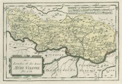 MÜHLVIERTEL. - Karte. - Des Landes ob der Enns Mühl Viertel Nro. 128.
Grenzkol. Kupferstich von Reilly, um 1790, 20 x 29 cm.
Zeigt die Donau von Passau bis St. Nikola im Osten, darüber Mühlviertel mit Freistadt im Mittelpunkt. (Artikelnr. 6499AG)
Erfahren Sie mehr180,00 € Inkl. MwSt.