Suchergebnisse für: "europa karte"
-
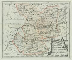
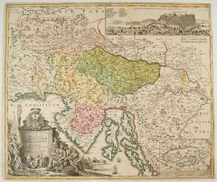
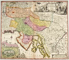
 ÖSTERREICH. - Karte. - Die Kronländer Österreich unter und ob der Enns und Salzburg.
Farblithographie aus Sohr-Berghaus bei Flemming, Glogau, um 1885, 33 x 41 cm.
Espenhorst, PP 4.1.3. - Aus: Sohr-Berghaus's "Hand-Atlas über alle Teile der Erde". (Artikelnr. 19460BG)
Erfahren Sie mehr80,00 € Inkl. MwSt. -
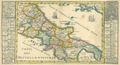
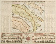
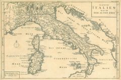 ITALIEN. - Karte. - Gantz Italien Nach Der Alten Zeit. Historische Gesamtkarte, mit Sardinien und Korsika.
Kupferstich, Halle, um 1760, 23 x 35 cm.
Aus "Übersetzung der Allgemeinen Welthistorie". - Geglättete Längsfalten. (Artikelnr. 33844EG)
Erfahren Sie mehr85,00 € Inkl. MwSt. -
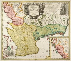
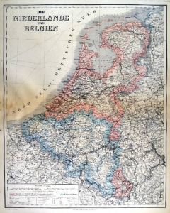 NIEDERLANDE. - Benelux. - Karte. - Die Niederlande und Belgien. Mit Luxemburg.
Kupferstich mit Farblithographie nach Kiepert, Weimar im Geograph. Institut, 1886, 62,5 x 50 cm.
Espenhorst, PP 1.1.6. - Aus: Heinrich Kiepert's "Grosser Hand-Atlas" (49. Ausgabe, Auflage 1886). - Zeigt die Küstenlinie von Spiekeroog bis ... (Artikelnr. 35167EG)
Erfahren Sie mehr85,00 € Inkl. MwSt. -
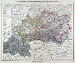
 SLOWENIEN. - Karte. - Tabula Ducatus Carnioliae Vindorum Marchiae et Histriae.
Altkol. Kupferstich von Johann Baptist Homann, um 1720, 49 x 57 cm.
Gesamtkarte der Anrainerstaaten der nördlichen Adria bis Klagenfurt. Mit dem Golf von Triest, Slowenien und Kroatien. Mit großer figürlichen Titelkartusche links unten,... (Artikelnr. 2082GG)
Erfahren Sie mehr450,00 € Inkl. MwSt. -
 ITALIEN. - Mittelitalien. - Karte. - Italien Eigentlich also genandt. Mit gestochenen Erklärungen an beiden Seiten.
Altkol. Kupferstich von Bodenehr, um 1720, 15,5 x 28 cm.
Zeigt Italien vom Lauf des Po bis südlich von Rom. (Artikelnr. 21019CG)
Erfahren Sie mehr100,00 € Inkl. MwSt. -
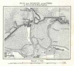 WKRA. - Karte. - Plan der Gegend an der Wkra zur Characteristik der Kriege Napoleons.
Lithographie bei Herder, Freiburg, um 1840, 15 x 19 cm.
Umgebungskarte zwischen Nowidwor, Pomiechowko und Czarnowo mit Zusammenfluss der Wrka und Narew. (Artikelnr. 17335AG)
Erfahren Sie mehr28,00 € Inkl. MwSt. -
 BÖHMEN. - Karte. - Des Königreichs Böheim Kreise Chrudim, Tschaslau und Kaurzim Nro. 99.
Grenzkol. Kupferstich von Reilly, um 1790, 22,5 x 32 cm.
Zeigt das Gebiet südlich von Königgrätz bis Tabor und Pilgram, links die Moldau mit Prag. (Artikelnr. 24399CG)
Erfahren Sie mehr120,00 € Inkl. MwSt. -
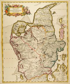
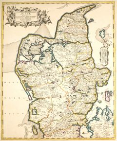 JÜTLAND. - Karte. - Jutiae Tabula in qua sunt ... Alburgensis, Wiburgensis, Ripensis et Arhusiensis.
Altkol. Kupferstich von Frederik de Wit bei P. Mortier, um 1680, 59 x 48 cm.
Grenzkolorierte Gesamtkarte der vier Herrschaften. Mit großer, figürlicher Titelkartusche links oben. (Artikelnr. 27051CG)
Erfahren Sie mehr250,00 € Inkl. MwSt. -
 JÜTLAND. - Karte. - Jutiae Tabula in qua sunt ... Alburgensis, Wiburgensis, Ripensis et Arhusiensis.
Altkol. Kupferstich von F. de Wit bei P. Mortier, um 1680, 59 x 48 cm.
Gesamtkarte der vier Herrschaften. Mit figürlicher, kolorierter Titelkartusche links oben. (Artikelnr. 19514CG)
Erfahren Sie mehr280,00 € Inkl. MwSt. -
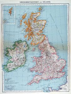
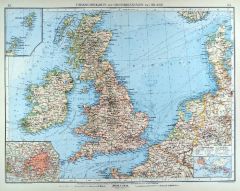 GROSSBRITANNIEN. - Karte. - Übersichtskarte von Grossbritannien und Irland. Mit drei Nebenkarten.
Farblithographie nach Scrobel aus Andree bei Velhagen & Klasing, 1900, 37,5 x 50 cm.
Espenhorst, PP 5.1.4. - Aus: Richard Andree's "Allgemeiner Handatlas" (4. Ausgabe, Auflage 1900). - Die Nebenkarten zeigen die Shetland- und Orkney-Inseln... (Artikelnr. 732FG)
Erfahren Sie mehr100,00 € Inkl. MwSt. -
GROSSBRITANNIEN. - Karte. - Übersichtskarte von Grossbritannien und Irland. Mit zwei Nebenkarten.
Farblithographie nach Scrobel aus Andree bei Velhagen & Klasing, 1893, 46,5 x 37 cm.
Espenhorst, PP 5.1.3. - Aus: Richard Andree's "Allgemeiner Handatlas" (3. Ausgabe, Auflage 1893). - Die Nebenkarten zeigen die "Kanal Inseln" und die "She... (Artikelnr. 34941EG)
Erfahren Sie mehr90,00 € Inkl. MwSt. -
FRANKREICH. - Karte. - Übersichtskarte von Frankreich, mit Korsika. Mit einer Nebenkarte.
Farblithographie nach Scrobel aus Andree bei Velhagen & Klasing, 1900, 36,5 x 46,5 cm.
Espenhorst, PP 5.1.4. - Aus: Richard Andree's "Allgemeiner Handatlas" (4. Ausgabe, Auflage 1900). - Die Nebenkarte zeigt eine Weltkarte: "Französische ... (Artikelnr. 726FG)
Erfahren Sie mehr85,00 € Inkl. MwSt. -
ITALIEN. - Karte. - Italien. Gesamtkarte, mit Nebenkarte "Malta Gozzo und Comino".
Grenzkol. Kupferstich von Maedel nach Weiland, Weimar im Geograph. Institut, dat. 1839, 58 x 50 cm.
Espenhorst, PP 1.1.3. - Zeigt die Riviera bis Toulon, im Norden Sterzing, die Dalmatinische Küste bis Ragusa, Korsika, Sardinien, Sizilien... (Artikelnr. 654FG)
Erfahren Sie mehr98,00 € Inkl. MwSt. -
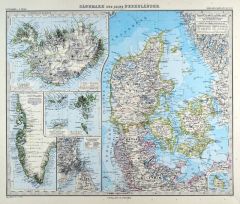 DÄNEMARK. - Karte. - Dänemark und seine Nebenländer. Gesamtkarte mit 6 Nebenkarten.
Kupferstich mit Farblithographie nach Vogel aus Stieler bei Perthes, Gotha, 1891, 33 x 40,5 cm.
Espenhorst, PP 2.1.1.1.8. - Aus: A. Stieler's "Hand-Atlas" (8. Ausgabe, Auflage 1891). - Die 6 Nebenkarten zeigen Island, Grönland, Bornholm, ... (Artikelnr. 19181BG)
Erfahren Sie mehr85,00 € Inkl. MwSt. -
TIROL. - Karte. - Südbayern, Tirol und Salzburg, mit Südtirol. Mit Anschlußkarte.
Farblithographie Simon nach Scrobel aus Andree bei Velhagen & Klasing, 1893, 36,5 x 48,5 cm.
Espenhorst, PP 5.1.3. - Aus: Richard Andree's "Allgemeiner Handatlas" (3. Ausgabe, Auflage 1893). - Zeigt das Gebiet zwischen München und (auf An... (Artikelnr. 35541EG)
Erfahren Sie mehr110,00 € Inkl. MwSt. -
SPANIEN und PORTUGAL. - Karte. - Spanien und Portugal. Gesamtkarte, mit Balearen.
Grenzkol. Kupferstich von Dellinger/Biedermann/Eyb nach Coello, Weimar im Geograph. Institut, um 1872, 52,5 x 65 cm.
Espenhorst, PP 1.1.6. - Aus: Heinrich Kiepert's "Grosser Hand-Atlas" (43. Ausgabe, Auflage 1872). - Gewann 1871 die einzig... (Artikelnr. 32902EG)
Erfahren Sie mehr118,00 € Inkl. MwSt. -
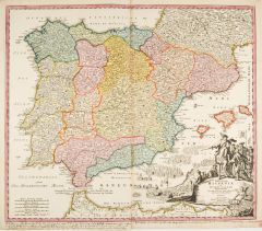
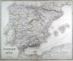 SPANIEN und PORTUGAL. - Karte. - Spanien und Portugal. Gesamtkarte, mit Balearen.
Grenzkol. Kupferstich von Dellinger und Biedermann nach Coello, Weimar im Geograph. Institut, 1873, 52,5 x 65 cm.
Espenhorst, PP 1.1.6. - Aus: Heinrich Kiepert's "Grosser Hand-Atlas" (44. Ausgabe, Auflage 1873). - Zeigt im Süden die norda... (Artikelnr. 35250EG)
Erfahren Sie mehr100,00 € Inkl. MwSt. -
 SLOWENIEN. - Karte. - Exactissima Ducatus Carniolae Vinidorum Marchiae et Historiae delineatio.
Altkol. Kupferstich von M. Seutter, um 1740, 49 x 57 cm.
Gesamtkarte der Anrainerstaaten der nördlichen Adria bis Klagenfurt. Mit dem Golf von Triest, Slowenien und Kroatien. Mit großer figürlichen Titelkartusche rechts oben und Nebenka... (Artikelnr. 27113CG)
Erfahren Sie mehr320,00 € Inkl. MwSt. -
 SCHWEDEN. - Karte. - Descriptio Nova et Accurata Scaniae, Blekingiae et Hallandiae.
Altkol. Kupferstich von M. Seutter, um 1740, 50 x 57,5 cm.
Teilkarte von Südschweden mit Nebenkarte von Gotland rechts unten. Mit großer Titelkartusche oben mittig und zwei kleineren Kartuschen rechts oben und links unten. - Schönes, kr... (Artikelnr. 10116CG)
Erfahren Sie mehr240,00 € Inkl. MwSt. -
 SPANIEN und PORTUGAL. - Karte. - Regnorum Hispaniae et Portugalliae Tabula Generalis.
Altkol. Kupferstich von Johann Baptist Homann, um 1720, 48,5 x 57 cm.
Gesamtkarte der iberischen Halbinsel mit den Balearen und der Küste von Nordafrika. Mit großer figürlicher Kartusche, Wappen und vielen Segelschiffen rechts unten. - ... (Artikelnr. 10084CG)
Erfahren Sie mehr240,00 € Inkl. MwSt. -
 ITALIEN. - Karte. - Übersichtskarte von Italien. Mit zwei Nebenkarten.
Farblithographie nach Scrobel aus Andree bei Velhagen & Klasing, 1899, 47 x 36,5 cm.
Espenhorst, PP 5.1.4. - Aus: Richard Andree's "Allgemeiner Handatlas" (4. Ausgabe, Auflage 1899). - "Mit dieser Ausgabe wurde der ANDREE zum führenden de... (Artikelnr. 35021EG)
Erfahren Sie mehr120,00 € Inkl. MwSt. -
FRANKREICH. - Karte. - Carte Géographique et Historique de la France avant 1790.
Grenzkol. Kupferstich von Marlier aus Dussieux bei Lecoffre, dat. 1846, 28 x 39 cm.
Aus: Louis Dussieux's "Atlas Général de Géographie". - Zeigt Frankreich mit den Gouvernements vor 1790. Mit ausführlichen Erklärungen. (Artikelnr. 34802EG)
Erfahren Sie mehr70,00 € Inkl. MwSt. -
FRANKREICH. - Karte. - Frankreich. Gesamtkarte, mit Nebenkarte Korsika und Umgebungsplan von Paris.
Grenzkol. Kupferstich nach Weiland, Weimar im Geograph. Institut, dat. 1841, 61 x 52,5 cm.
Espenhorst, PP 1.1.3. - Mit grenzkol. Einteilung nach Departements. - Rechts gering wasserrandig. Mehrere von alter Hand farbig eingezeichnete Reise... (Artikelnr. 657FG)
Erfahren Sie mehr128,00 € Inkl. MwSt. -
GROSSBRITANNIEN. - Karte. - Grossbritannien. England, Scotland und Ireland. Gesamtkarte, oben die Shetlandinseln.
Farblithographie aus J.M. Ziegler bei J. Wurster, Winterthur, 1864, 55,5 x 42 cm.
Espenhorst, PP 65.1. - Aus: Jakob Melchior Ziegler's "Geographischer Atlas über alle Theile der Erde" (2. Auflage von 1864). - Leicht fleckig. (Artikelnr. 18993BG)
Erfahren Sie mehr150,00 € Inkl. MwSt. -
 ITALIEN. - Karte. - Italie das son premier etablissement sous la republique Romaine.
Altkol. Kupferstich von Chatelain, 1705, 34 x 44 cm.
Italienkarte zur Zeit Cäsars, seitlich Erläuterungen und Tabellen, im unteren Rand Grundriss des antiken Rom, seitlich zwei Darstellungen von Triumphzügen mit Reitern, Kampfwagen und ... (Artikelnr. 27036CG)
Erfahren Sie mehr240,00 € Inkl. MwSt. -
ITALIEN. - Karte. - Italien. Schöne Gesamtkarte mit Sizilien, Korsika, Sardinien und Malta.
Farblithographie aus J.M. Ziegler bei J. Wurster, Winterthur, 1864, 56 x 44,5 cm.
Espenhorst, PP 65.1. - Aus: Jakob Melchior Ziegler's "Geographischer Atlas über alle Theile der Erde" (2. Auflage von 1864). - Leicht fleckig. (Artikelnr. 19001BG)
Erfahren Sie mehr180,00 € Inkl. MwSt. -
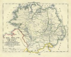
 UKRAINE. - Karte. - Taurica Chersonesus VS. Nostra aetate Przecopsca et Gazara dicitur.
Kupferstich nach Gerard Mercator, um 1630, 31,5 x 40 cm.
Zeigt die Ukraine mit der Halbinsel Krim, dem Asowschen Meer und dem nördlichen Schwarzen Meer. Oben rechts Titelkartusche, unten links Meilenzeiger, darunter Verlegername und Druck... (Artikelnr. 25699CG)
Erfahren Sie mehr250,00 € Inkl. MwSt. -
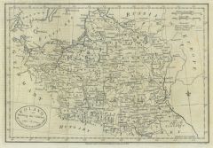 POLEN. - Karte. - Poland shewing(sic!) the Claims of Austria, Russia & Prussia.
Kupferstich von J. Cary bei Fielding, London, dat. 1782, 19 x 28 cm.
Zeigt das Gebiet Polens vor der ersten Teilung 1772, mit den Gebietsansprüchen Österreichs, Rußlands und Österreichs. Längsfalten, z.T. leichter Abklatsch von Typogr... (Artikelnr. 35858EG)
Erfahren Sie mehr98,00 € Inkl. MwSt. -
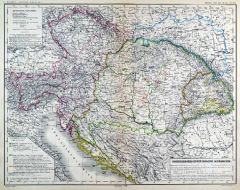 ÖSTERREICH und UNGARN. - Karte. - Österreichisch-Ungrische Monarchie. Gesamtkarte mit "Ausserdeutsche Kronländer".
Grenzkol. Lithographie von Sulzer aus Kiepert bei Reimer, 1875, 33,5 x 43 cm.
Espenhorst, PP 20.3.2. - Aus: Heinrich Kiepert's "Kleiner Hand-Atlas der neueren Geographie für Schule und Haus" (Ausgabe 1875). - Berichtigt 1874. (Artikelnr. 35293EG)
Erfahren Sie mehr85,00 € Inkl. MwSt. -
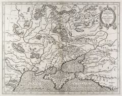
UNGARN. - Karte. - Nuova Carta del Tegno di Ungheria e della Transilvania.
Kupferstich von Isaak Tirion, Amsterdam, um 1740, 26 x 30,5 cm.
Zeigt die Donau von Krainburg bis Widdin, reicht im Norden bis Olmütz, im Westen bis Laibach, im Süden bis Belgrad, im Osten bis Kronstadt. (Artikelnr. 15013AG)
Erfahren Sie mehr130,00 € Inkl. MwSt. -
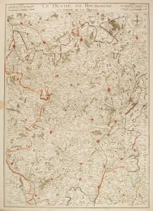 BURGUND. - Karte. - Le Duché de Bourgogne et Partie de la Bresse.
Kupferstich nach "de Vit und de Vischer", dat. 1737, 65 x 48,5 cm.
Die grenzkolorierte Gebietskarte zeigt Burgund mit Teilen von Bresse. - Links im Bug kleiner Braunfleck außerhalb der Darstellung. (Artikelnr. 2416GG)
Erfahren Sie mehr180,00 € Inkl. MwSt. -
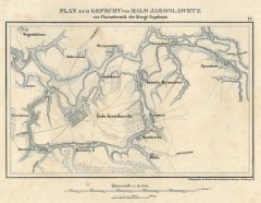 MALO-JAROSLAWETZ. - Karte. - Plan zum Gefecht von Malo Jaroslawetz zur Characteristik der Kriege Napoleons.
Lithographie bei Herder, Freiburg, um 1840, 13 x 21 cm.
Umgebungskarte bis Bogodukhino, Illinka, Spasskoie. - Insgesamt etwas stockfleckig. (Artikelnr. 17332AG)
Erfahren Sie mehr28,00 € Inkl. MwSt. -
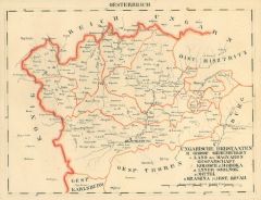 SIEBENBÜRGEN. - Karte. - Grossf. Siebenbürgen. Land der Magyaren, Gespannschaft Kolosch, Doboka, Szolnok, Kraszna und Kövar.
Grenzkol. Lithographie bei Schlieben, 1829, 20 x 26 cm.
Gebietskarte mit Klausenburg im Süden bis Nagybanya im Norden. (Artikelnr. 13966CG)
Erfahren Sie mehr68,00 € Inkl. MwSt. -
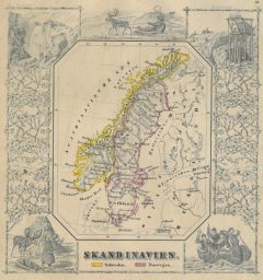 SKANDINAVIEN. - Karte. - Skandinavien. Schweden. Norwegen. Gesamtkarte (13,5 x 11 cm), umgeben von landestypischen Szenen.
Grenzkol. Kupferstich bei J. Berlin, 1853, 16 x 20,5 cm.
Espenhorst, PP 63,5. - Im Rand gering unfrisch. (Artikelnr. 27135CG)
Erfahren Sie mehr100,00 € Inkl. MwSt. -
NIEDERLANDE. - Benelux. - Karte. - Die Niederlande und Belgien, mit Luxemburg. Gesamtkarte der Beneluxstaaten.
Grenzkol. Kupferstich von Eulenstein nach Kiepert und Gräf, Weimar im Geograph. Institut, dat. 1856, 62 x 49 cm.
Espenhorst, PP 1.1.5. - Aus: Heinrich Kiepert's "Hand-Atlas" (42. Ausgabe, 1856/69). (Artikelnr. 33159EG)
Erfahren Sie mehr110,00 € Inkl. MwSt. -
 GROSSBRITANNIEN. - Karte. - Grossbritannien und Irland. Gesamtkarte, mit Nebenkarte Shetland- und Orkney-Inseln.
Farblithographie nach Wolf aus Spamer, 1902, 41,5 x 31,5 cm.
Espenhorst, PP 23.2. - Aus: O. Spamer's "Grosser Hand-Atlas" (2. Ausgabe, Auflage 1902). - Verso Typographie, mit 9 Gebietskarten. (Artikelnr. 35090EG)
Erfahren Sie mehr85,00 € Inkl. MwSt. -
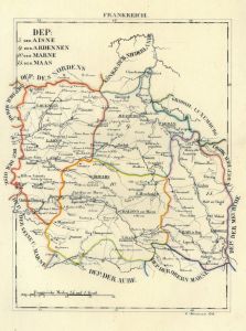 ISLE DE FRANCE. - Karte. - Dep: der Aisne, der Ardennen, der Marne, der Maas.
Grenzkol. Lithographie von Hermann bei Schlieben, 1829, 26 x 20 cm.
Gebietskarte zwischen St. Quentins, Mezieres, Reims, Epernay und Bar de luc. (Artikelnr. 18739AG)
Erfahren Sie mehr66,00 € Inkl. MwSt. -
 KAURZIM. - Karte. - Elbelauf von Nimburg bis Lohenitz, im Norden Rozdialowitz, im Süden Janowitz.
Kupferstich, Weimar im Geograph. Institut, 1807, 32 x 41 cm.
Sehr detaillierte Sektionskarte (113) mit auch kleinsten Orten, Gewässern etc. - Etwas knapprandig. (Artikelnr. 9900AG)
Erfahren Sie mehr66,00 € Inkl. MwSt. -
FRANKREICH. - Nordfrankreich. - Karte. - Der Nordöstliche Theil von Frankreich. Gebietskarte.
Grenzkol. Kupferstich von Jättnig aus Stieler bei Perthes, Gotha, dat. 1820, 35 x 29 cm.
Espenhorst, PP 2.1.1.1.0.a. - Aus: A. Stieler's "Hand-Atlas" (Zero Edition, basic version). - Mit grenzkol. Einteilung nach Departements. Zeigt das G... (Artikelnr. 33197EG)
Erfahren Sie mehr75,00 € Inkl. MwSt. -
DÄNEMARK. - Karte. - Daenemark mit Holstein u. Lauenburg, mit Nebenkarte.
Grenzkol. Kupferstich aus Stieler bei Perthes, Gotha, dat. 1819, 29 x 34,5 cm.
Espenhorst, PP 2.1.1.1.0.a. - Aus: A. Stieler's "Hand-Atlas". ("Initial Version (Urausgabe)"). - Zeigt im Osten Südschweden und Mecklenburg. Die Nebenkarte zei... (Artikelnr. 33217EG)
Erfahren Sie mehr95,00 € Inkl. MwSt. -
SKANDINAVIEN. - Karte. - Dänemark, Island u. Faröer, Schweden und Norwegen.
Grenzkol. Kupferstich aus Stieler bei Perthes, Gotha, dat. 1822, 28,5 x 35 cm.
Espenhorst, PP 2.1.1.1.0.a. - Aus: A. Stieler's "Hand-Atlas". ("Initial Version (Urausgabe)"). - Zeigt im Osten Finnland, Baltikum und Polen, im Süden Großbri... (Artikelnr. 33218EG)
Erfahren Sie mehr95,00 € Inkl. MwSt. -
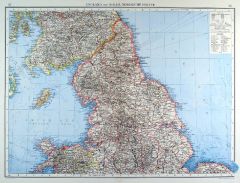 GROSSBRITANNIEN. - Nordengland. - Karte. - England und Wales. Nördliche Hälfte.
Farblithographie von Wagner nach Umbreit aus Andree bei Velhagen & Klasing, 1899, 36,5 x 49,5 cm.
Espenhorst, PP 5.1.4. - Aus: Richard Andree's "Allgemeiner Handatlas" (4. Ausgabe, Auflage 1899). - "Mit dieser Ausgabe wurde der ANDREE zum ... (Artikelnr. 35013EG)
Erfahren Sie mehr90,00 € Inkl. MwSt. -
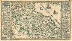
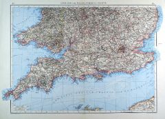 GROSSBRITANNIEN. - Südengland. - Karte. - England und Wales. Südliche Hälfte.
Farblithographie von Anschütz nach Umbreit aus Andree bei Velhagen & Klasing, 1899, 37 x 49,5 cm.
Espenhorst, PP 5.1.4. - Aus: Richard Andree's "Allgemeiner Handatlas" (4. Ausgabe, Auflage 1899). - "Mit dieser Ausgabe wurde der ANDREE zum... (Artikelnr. 35012EG)
Erfahren Sie mehr90,00 € Inkl. MwSt.