Suchergebnisse für: "ansichten ausland europa russland"
-
RUSSLAND. - Karte. - Carte Générale de L'Empire des Russes et de la Tatarie Universelle. Gesamtkarte.
Grenzkol. Kupferstich von R. de Vaugondy, dat. 1769, 16 x 20,5 cm.
Zeigt das Gebiet von Polen bis zum Pazifik mit Japan, im Südosten China. (Artikelnr. 32539EG)
Erfahren Sie mehr98,00 € Inkl. MwSt. -
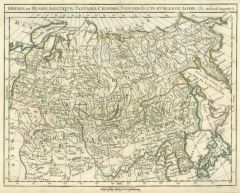 RUSSLAND. - Asiatischer Teil. - Karte. - Siberie ou Russie Asiatique, Tartarie Chinoise, Pays des Fluts et Isles du Japon.
Grenzkol. Kupferstich von R. de Vaugondy, um 1780, 24 x 31 cm.
Zeigt das Gebiet vom Polen bis zum Pazifik mit Japan, im Südosten Korea. (Artikelnr. 32540EG)
Erfahren Sie mehr128,00 € Inkl. MwSt. -
 RUSSLAND. - Tracht. - Fünf Darstellungen von Ureinwohnern Sibiriens auf einem Blatt: Sibirischer Buchar, Kalmücke, Baschkir, Mann und Frau von den Jakuten.
Altkol. Radierung von Cl. Kohl nach Sollerer, Wien, 1791, 16 x 11,5 cm.
Mit vollständigem vierseitigen Text. (Artikelnr. 2234EG)
Erfahren Sie mehr85,00 € Inkl. MwSt. -
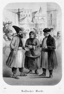 RUSSLAND. - Tracht. - Russischer Markt. Blick auf das Markttreiben, vorne ein Bauernpaar in Tracht, dazu ein Mann mit hoher Mütze, besticktem Mantel und Pantoffeln.
Altkol. Lithographie mit Tonplatte, dat. 1867, 14,5 x 10,5 cm.
Im Rand leicht fingerfleckig. (Artikelnr. 26406EG)
Erfahren Sie mehr57,00 € Inkl. MwSt. -
RUSSLAND. - Schaukel. - Blick auf eine Volksbelustigung mit Schaukeln "auf dem Platze vor dem steinernen Theater zu St. Petersburg".
Altkol. Radierung von J.B. Pfitzer, um 1810, 9,5 x 15 cm.
Mit dem vollständigen, die verschiedenen Arten von Schaukeln genau erklärenden Text "Fig. 2. Russische Schaukeln". - Oben bis zur Einfassungslinie beschnitten und angerändert. Gu... (Artikelnr. 2286EG)
Erfahren Sie mehr57,00 € Inkl. MwSt. -
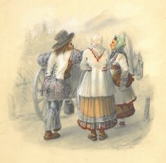 RUSSLAND. - Tracht. - Russische Bauern in Tracht. Ein Mann und zwei Frauen an einem Fuhrwerk stehend, von hinten betrachtet.
Aquarellierte Bleistiftzeichnung von Ludwig Franz Karl Bohnstedt, sign. und dat. "St. Petersburg 1845", 25 x 22 cm (Blattgröße).
Der Architekt Ludwig Bohnstedt (1822-1885) studierte in Berlin und arbeitete ab 1854 als Hofarchitekt und Pr... (Artikelnr. 43564EG)
Erfahren Sie mehr400,00 € Inkl. MwSt. -
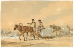 RUSSLAND. - Eistransport. - Männer transportieren jeweils einen großen Eisblock auf Pferdeschlitten. Links im Hintergrund weitere Eiswerker, sowie Gebäude.
Aquarell mit Deckweiß über Bleistift von Karl Ivanovitch Kollmann, sign. "Collman", um 1800, 16 x 24 cm.
Thieme-Becker Bd. XXI, S. 243. - Der in St. Petersburg tätige Aquarellmaler Karl Ivanovitch Kollmann (1786-1846) war bekannt für s... (Artikelnr. 43142EG)
Erfahren Sie mehr1.200,00 € Inkl. MwSt. -
RUSSLAND. - Russisch-Orthodoxe Taufe. - Ceremonies in Christening observed by the Russians etc. Blick in eine orthodoxe Kirche, der Pope taucht den Täufling in ein Becken, dazu Kirchendiener und Angehörige.
Kupferstich, 1788, 16,5 x 36 cm.
Aus "Dr. Hurd's Religious Rites & Ceremonies of all Nations". (Artikelnr. 33482EG)
Erfahren Sie mehr78,00 € Inkl. MwSt. -
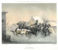 RUSSLAND. - Schlittenfahrt. - Attellages Russes. Blick auf einen Pferdeschlitten mit Troika, Fuhrmann und sieben Passagieren in Pelzdecken und -mänteln bei der winterlichen Fahrt durch ein russisches Dorf, mit Unterschrift in Russisch.
Farblithographie von Schultz nach Gr(o)usinsky bei Velten, St. Petersburg, um 1870, 17 x 23 cm. (Artikelnr. 29593EG)
Erfahren Sie mehr160,00 € Inkl. MwSt. -
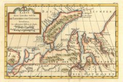
 RUSSLAND. - Karte. - Conspectus recens et accuratus magnae partis Lacus Ladogae et Sinus Finnici cum interjacentius et adjacentibg regionibus ad exemplar Petropolitanum.
Altkol. Kupferstich von Matthäus Seutter, um 1740, 50 x 57 cm.
Die grenzkolorierte Karte zeigt den Großraum von Sankt Petersburg mit dem östlichen Teil des Finnischen Meerbusen und dem südwestlichen Teil des Ladogasees, mit Einzeichnun... (Artikelnr. 2389GG)
Erfahren Sie mehr1.200,00 € Inkl. MwSt. -
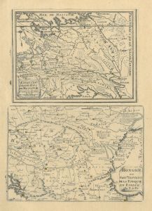 RUSSLAND. - Karte. - Estats du Grand Duc de Moscovie und "Hongrie ou Partie Septent. de la Turquie en Europe". Zwei Karten auf einem Blatt.
2 Kupferstiche von Nicolas de Fer, um 1700, 28 x 20 cm.
Die Russlandkarte reicht vom Asowschen Meer im Süden bis zum Weißen Meer im Norden. Die Ungarnkarte reicht von Wien bis Constantinopel. - Mit dem Textblatt. - Minimal gebräunt. (Artikelnr. 2398GG)
Erfahren Sie mehr280,00 € Inkl. MwSt. -
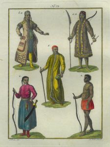
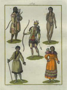 RUSSLAND. - Tracht. - Fünf Darstellungen von Ureinwohnern Sibiriens auf einem Blatt: Tunguse mit Pfeil und Bogen, Mann und Frau der Kamtschadalen (Halbinsel Kamtschatka), Mann von den Kurilen mit Pfeil und Bogen und Frau von den Tschukts
Altkol. Radierung von Cl. Kohl nach Sollerer, Wien, 1791, 16 x 11,5 cm.
Mit vollständigem vierseitigen Text. (Artikelnr. 2233EG)
Erfahren Sie mehr85,00 € Inkl. MwSt. -
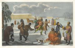 RUSSLAND. - Schlittschuhlaufen. - Winterliches Eislaufvergnügen auf einem gefrorenen See vor einem großen Schloß. Zahlreiche Männer, teils in russischer Tracht, laufen auf Kufen, andere trinken Glühwein und auch eine Kutsche auf Kufe
Altkol. Aquatinta von A. Biasioli nach Bramatti, um 1820, 18 x 29 cm.
Aus: Ferrario, "Il Costume Antico e Moderno". - Zeigt wohl Schloß Peterhof in St. Petersburg. - In leuchtend frischem Kolorit. - Oben rechts num. "20". (Artikelnr. 43020EG)
Erfahren Sie mehr300,00 € Inkl. MwSt. -
KAPURGA. - Gesamtansicht, darunter Ansicht von Gama.
Kupferstich von J. Stridbeck, um 1700, 16 x 14 cm.
Fauser 6893. - Zwei Ansichten auf einem Blatt. (Artikelnr. 22194CG)
Erfahren Sie mehr100,00 € Inkl. MwSt. -
MOSKAU. - Sammlung von drei Souvenirblättern.
3 Stahlstiche, um 1840, je ca. 17 x 22 cm.
Um eine zentrale Ansicht sind jeweils 8 Ansichten in reicher floraler Umrahmung dargestellt. Sie zeigen Schlösser, Kirchen und andere Sehenswürdigkeiten. Alle Ansichten in kyrillischer Sprache b... (Artikelnr. 24270CG)
Erfahren Sie mehr180,00 € Inkl. MwSt. -
 NOWAJA SEMLJA. - Karte. - Karte derer Laender welche die Samojeden und Ostiaken bewohnen.
Altkol. Kupferstich, um 1780, 15 x 23,5 cm.
Die Karte zeigt die Insel Nowaja Semlja im Eismeer und Teile von Nordwest-Russland. (Artikelnr. 2703GG)
Erfahren Sie mehr80,00 € Inkl. MwSt. -
MOSKAU. - The Kremlin. From the Quay, Moskow. Blick vom Moskwa-Ufer zum Kreml.
Stahlstich von Willmore nach Vickers, London, um 1840, 9,5 x 14,5 cm.
Thieme-Becker Bd. XXXIV, S. 328: Vickers war "1833 in Rußland zwecks Anfertigung von Zeichnungen" usw. - Mit Staffage. (Artikelnr. 36158EG)
Erfahren Sie mehr58,00 € Inkl. MwSt. -
SKANDINAVIEN. - Karte. - Gesamtkarte des nördlichen Ostseeraums mit Norwegen, Schweden und Finnland, in vier Teilen.
Mehrfarbendruck in Typometrie von F. Raffelsberger bei J. Bermann, Wien, 1843, je ca. 34 x 51 cm (3x) bzw. 33 x 22 cm (1x).
Aus "Erste typometrische General-Karte von Europa", Wien, 1843. - Die vier Karten zeigen Norwegen und Finnland komp... (Artikelnr. 589FG)
Erfahren Sie mehr320,00 € Inkl. MwSt. -
14,00 € Inkl. MwSt.
-
19,00 € Inkl. MwSt.
-
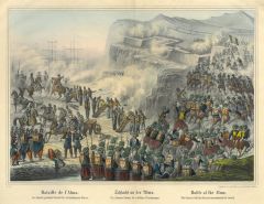 SEWASTOPOL. - Krimkrieg. - Schlacht an der Alma. Die Zouaven stürmen die russischen Verschanzungen.
Altkol. Lithographien bei Joseph Scholz, Mainz, um 1855, 24 x 34 cm.
Die Schlacht an der Alma am 20. September 1854 war eine Schlacht im Krimkrieg zwischen Russland einerseits und Frankreich und Großbritannien andererseits. Sie war das er... (Artikelnr. 2736GG)
Erfahren Sie mehr220,00 € Inkl. MwSt. -
32,00 € Inkl. MwSt.
-
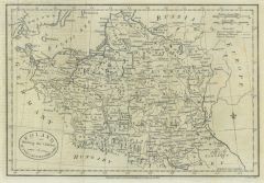 POLEN. - Karte. - Poland shewing(sic!) the Claims of Austria, Russia & Prussia.
Kupferstich von J. Cary bei Fielding, London, dat. 1782, 19 x 28 cm.
Zeigt das Gebiet Polens vor der ersten Teilung 1772, mit den Gebietsansprüchen Österreichs, Rußlands und Österreichs. Längsfalten, z.T. leichter Abklatsch von Typogr... (Artikelnr. 35858EG)
Erfahren Sie mehr98,00 € Inkl. MwSt. -
32,00 € Inkl. MwSt.
-
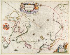 NORDPOL. - Karte. - Regiones sub Polol Arctico.
Altkolorierter Kupferstich bei W.J. Blaeu, um 1645, 41 x 53 cm.
Karte der Polargegend mit dem nördlichen Kanada, Grönland, Island, Lappland und dem nördlichen Russland. - Oben mittig altkolorierte Titelkartusche, links Wappenkartusche u... (Artikelnr. 26327CG)
Erfahren Sie mehr900,00 € Inkl. MwSt. -
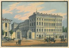 PETERSBURG. - Hübsche Ansicht eines Stadtpalais.
Altkol. Umrißradierung, um 1820, 10 x 15 cm (auf Einfassungslinie beschnitten). (Artikelnr. 688AG)
Erfahren Sie mehr114,00 € Inkl. MwSt. -
38,00 € Inkl. MwSt.
-
ERZERUM/Armenien. - Ansicht von Erzerum. Gesamtansicht.
Holzstich, 1878, 15 x 48,5 cm (mit kleiner Hinterlegung im Bug). (Artikelnr. 19616BG)
Erfahren Sie mehr55,00 € Inkl. MwSt. -
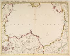 SCHWARZES MEER. - Seconde Partie de la Crimée, la Mer Noire.
Altkol. Kupferstich bei Covens & Mortier, Amsterdam, um 1730, 47 x 61 cm.
Die flächenkolorierte Karte zeigt das Schwarze Meer und einen kleinen Teil der Halbinsel Krim, sowie der Türkei, Bulgarien, Armenien, Rumänien und Rußland. - In ... (Artikelnr. 2825GG)
Erfahren Sie mehr340,00 € Inkl. MwSt. -
28,00 € Inkl. MwSt.
-
28,00 € Inkl. MwSt.
-
20,00 € Inkl. MwSt.
-
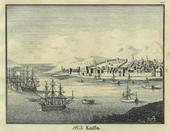
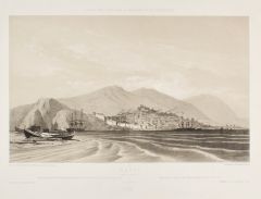 FEODOSSIJA/Krim. - Kaffa. Ansicht vom Meer aus.
Lithographie mit Tonplatte von Eugene Cicéri und Philippe Benoist nach Durand-Brager bei Lemercier, um 1840, 25,5 x 41,5 cm. (Artikelnr. 2731GG)
Erfahren Sie mehr320,00 € Inkl. MwSt. -
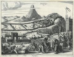 DERBENT/Kaukasus. - Derbendt. Gesamtansicht der am Berg gelegenen Stadt, im Vordergrund Wallfahrt und Beerdigungsszene.
Kupferstich, um 1680, 24 x 32 cm.
Lebendige Ansicht, mit zahlreichen Landleuten und zwei Kamelen staffagiert. (Artikelnr. 27686CG)
Erfahren Sie mehr250,00 € Inkl. MwSt. -
24,00 € Inkl. MwSt.
-
43,00 € Inkl. MwSt.
-
24,00 € Inkl. MwSt.
-
38,00 € Inkl. MwSt.
-
24,00 € Inkl. MwSt.
-
48,00 € Inkl. MwSt.
-
28,00 € Inkl. MwSt.
-
TIFLIS. - Der Meidan. Ansicht mit zahlreichen Personen, Ochsenfuhrwerk und Kamelen.
Holzstich nach Dmitrijew-Orenburgsky, um 1880, 21,5 x 30 cm. cm (verso ohne Text). (Artikelnr. 20875CG)
Erfahren Sie mehr42,00 € Inkl. MwSt. -
24,00 € Inkl. MwSt.
-
28,00 € Inkl. MwSt.