Suchergebnisse für: "europa karte"
-
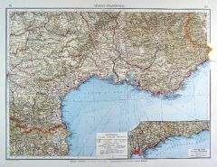
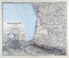
 FRANKREICH. - Südfrankreich. - Karte. - Frankreich. Südliche Hälfte. Mit Nebenkarte.
Farblithographie nach Scrobel aus Andree bei Velhagen & Klasing, 1899, 36,5 x 45,5 cm.
Espenhorst, PP 5.1.4. - Aus: Richard Andree's "Allgemeiner Handatlas" (4. Ausgabe, Auflage 1899). - "Mit dieser Ausgabe wurde der ANDREE zum führenden ... (Artikelnr. 35007EG)
Erfahren Sie mehr100,00 € Inkl. MwSt. -
 FRANKREICH. - Südfrankreich. - Karte. - Südost-Frankreich. Mit Nebenkarte.
Farblithographie von Endlich nach Köcher aus Andree bei Velhagen & Klasing, 1899, 37 x 49,5 cm.
Espenhorst, PP 5.1.4. - Aus: Richard Andree's "Allgemeiner Handatlas" (4. Ausgabe, Auflage 1899). - "Mit dieser Ausgabe wurde der ANDREE zum f... (Artikelnr. 35010EG)
Erfahren Sie mehr110,00 € Inkl. MwSt. -
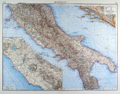 ITALIEN. - Mittelitalien. - Karte. - Mittelitalien. Mit einer Nebenkarte.
Farblithographie nach Scrobel aus Andree bei Velhagen & Klasing, 1899, 37 x 49 cm.
Espenhorst, PP 5.1.4. - Aus: Richard Andree's "Allgemeiner Handatlas" (4. Ausgabe, Auflage 1899). - "Mit dieser Ausgabe wurde der ANDREE zum führenden deut... (Artikelnr. 35022EG)
Erfahren Sie mehr120,00 € Inkl. MwSt. -
 ITALIEN. - Lombardei. - Karte. - Die Obere oder Westliche Lombardia. Mit gestochenen Erklärungen an beiden Seiten.
Altkol. Kupferstich von Bodenehr, um 1720, 15,5 x 28 cm.
Zeigt das westliche Oberitalien mit der Küste bis Livorno. (Artikelnr. 21022CG)
Erfahren Sie mehr110,00 € Inkl. MwSt. -
 SCHWEIZ. - Karte. - Carte Générale Physique et Routière des 22 Cantons de la Confédération Suisse.
Kupferstich von H. Brue, Paris, dat. 1822, 36 x 50,5 cm.
Sehr detaillierte, grenzkolorierte Gesamtkarte der Schweiz. - Gut erhalten. (Artikelnr. 2421GG)
Erfahren Sie mehr180,00 € Inkl. MwSt. -
 FRANKREICH. - Karte. - Frankreich in 4 Blättern. Gesamtkarte in 4 Blättern.
4 Kupferstiche mit Farblithographie von Weiler nach Vogel aus Stieler bei Perthes, Gotha, 1891, je 33 x 41 cm.
Espenhorst, PP 2.1.1.1.8. - Aus: A. Stieler's "Hand-Atlas" (8. Ausgabe, Auflage 1891). - Zeigt gesamt Frankreich in einem Maasst... (Artikelnr. 19170BG)
Erfahren Sie mehr220,00 € Inkl. MwSt. -
 SAVOYEN. - Karte. - Regiae celsitudinis Sabaudicae Status in quo Ducatus Sabaudiae.
Altkol. Kupferstich von J.B. Homann, um 1720, 50 x 57 cm.
Zeigt den französischen Teil südlich des Genfer Sees, die italienischen Seen mit Mailand und das Gebiet bis zum Mittelmeer (Nizza, Monte Carlo und Genua). Mit großer figürlicher... (Artikelnr. 24697CG)
Erfahren Sie mehr220,00 € Inkl. MwSt. -
TOULON. - Karte. - Toulon. Kleinteilige Umgebungskarte mit Hafen und Presqu'Ile Cepet.
Kupferstich von Jacobs nach Duvotenay aus Lavallée bei Furne, Paris, 1858, 14 x 23 cm.
Aus: Théophile Lavallée's "Atlas de Géographie Militaire". - Zeigt im Norden Ollioules, im Osten La Valette, die Küste von Ft. Ste. Marguerite bis ... (Artikelnr. 34873EG)
Erfahren Sie mehr60,00 € Inkl. MwSt. -
FRANKREICH. - Nordfrankreich. - Karte. - Frankreich. Nördliche Hälfte. Mit Anschluß- und Nebenkarte.
Farblithographie nach Scrobel aus Andree bei Velhagen & Klasing, 1900, 36,5 x 45,5 cm.
Espenhorst, PP 5.1.4. - Aus: Richard Andree's "Allgemeiner Handatlas" (4. Ausgabe, Auflage 1900). - Die Anschlußkarte zeigt die Bretagne, die Nebenkart... (Artikelnr. 727FG)
Erfahren Sie mehr90,00 € Inkl. MwSt. -
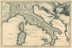
ITALIEN. - Karte. - Per Italiam Cursus publici & Ciarum Militarium accuratissima vestigia.
Altkol. Kupferstich bei Chr. Weigel, 1718, 32,5 x 40 cm.
Aus: Johann David Köhlers "Bequemer Schul= und Reisen=Atlas", 1718. - Schöne Gesamtkarte mit Sardinien und Korsika. Straßenkarte der wichtigsten öffentlichen Straßen, zum Teil a... (Artikelnr. 18642BG)
Erfahren Sie mehr320,00 € Inkl. MwSt. -
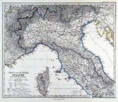
ITALIEN. - Norditalien. - Karte. - Charte von Nord- oder Ober-Italien. Gebietskarte.
Grenzkol. Kupferstich nach Streit, Weimar im Geograph. Institut, dat. 1825, 49,5 x 67 cm.
Espenhorst, PP 1.1.2. - Zeigt das Gebiet von Bozen im Norden bis Gaeta bzw. Foggia im Süden, dazu Korsika und die Dalmatien bis Sebenico. Mit Farber... (Artikelnr. 33044EG)
Erfahren Sie mehr92,00 € Inkl. MwSt. -
ITALIEN. - Norditalien. - Karte. - Italie Septentrionale Divisée en ses différens États.
Grenzkol. Kupferstich aus Delamarche, dat. 1833, 27,5 x 40,5 cm.
Aus: Felix Delamarche's "Atlas de la Géographie ancienne, du moyen-age et moderne". - Der Ingenieur und Mechaniker für Erd- und Himmelsgloben übernahm 1811 das Atlantenges... (Artikelnr. 34833EG)
Erfahren Sie mehr90,00 € Inkl. MwSt. -
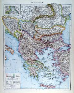 BALKAN. - Karte. - Balkanhalblinsel. Gesamtkarte bis Kreta, mit Anschlußkarte "Moldau" (Nordrumänien).
Farblithographie aus Andree bei Velhagen & Klasing, 1881, 47 x 37 cm.
Espenhorst, PP 5.1.1. - Aus: Richard Andree's "Allgemeiner Handatlas" (1. Ausgabe, Auflage 1881). - Verso 4 weitere Darstellungen: "Mittelmeerländer Östliche Hälfte",... (Artikelnr. 35335EG)
Erfahren Sie mehr95,00 € Inkl. MwSt. -
ÖSTERREICH und UNGARN. - Karte. - Der Österreichische Kaiserstaat. Gesamtkarte der Monarchie.
Grenzkol. Kupferstich nach Vogel aus Stieler bei Perthes, Gotha, 1866, 33 x 40 cm.
Espenhorst, PP 2.1.1.1.4. - Aus: A. Stieler's "Hand-Atlas" (4. Ausgabe, Auflage 1866). - Zeigt Österreich und die Ungarischen Kronländer, mit der "Militä... (Artikelnr. 34904EG)
Erfahren Sie mehr60,00 € Inkl. MwSt. -
SCHWEIZ. - Karte. - Die Schweiz. Gesamtkarte, mit Nebenkarte "Politische Übersicht" (Kantonseinteilung).
Farblithographie nach Scrobel aus Andree bei Velhagen & Klasing, 1899, 36,5 x 47,5 cm.
Espenhorst, PP 5.1.4. - Aus: Richard Andree's "Allgemeiner Handatlas" (4. Ausgabe, Auflage 1899). - "Mit dieser Ausgabe wurde der ANDREE zum führenden ... (Artikelnr. 35003EG)
Erfahren Sie mehr80,00 € Inkl. MwSt. -
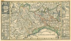
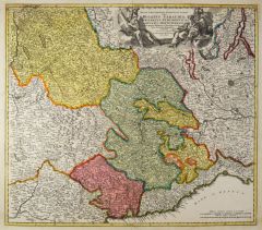
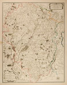
 SLAWONIEN. - Karte. - Tabula Geographica exhibens Regnum Sclavoniae cum Syrmii Ducatu.
Altkol. Kupferstich von Homann Erben, dat. 1745, 46,5 x 55,5 cm.
Zeigt das Gebiet zwischen Donaulauf und Bosnien, im Osten Belgrad. Mit großer figürlicher Kartusche rechts oben, Kopftitel in französisch und gestochenen Erklärungen link... (Artikelnr. 10109CG)
Erfahren Sie mehr220,00 € Inkl. MwSt. -
 BURGUND. - Karte. - Le Comté de Bourgogne ou la Franche Comté.
Altkol. Kupferstich bei Saint Jacques, um 1790, 62,5 x 48,5 cm.
Die grenzkolorierte Gebietskarte zeigt die Region um Besancon, im Westen von Beaune bis Neuchatel im Osten, im Süden von Louhans bis ins Elsaß. - Mit einem alt hinterlegten ... (Artikelnr. 2415GG)
Erfahren Sie mehr180,00 € Inkl. MwSt. -
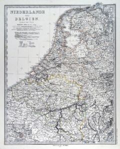
NIEDERLANDE. - Benelux. - Karte. - Niederlande und Belgien, mit Luxemburg. Mit zwei Nebenkarten.
Farblithographie nach Scrobel aus Andree bei Velhagen & Klasing, 1900, 49,5 x 37,5 cm.
Espenhorst, PP 5.1.4. - Aus: Richard Andree's "Allgemeiner Handatlas" (4. Ausgabe, Auflage 1900). - Die Nebenkarten zeigen "Die Niederlande, physisch" u... (Artikelnr. 725FG)
Erfahren Sie mehr75,00 € Inkl. MwSt. -
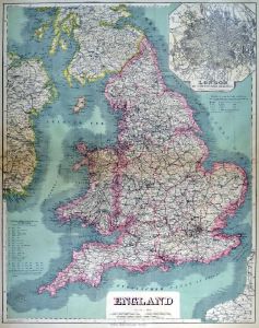 GROSSBRITANNIEN. - England. - Karte. - England. Mit Nebenkarte "London mit seinen nächsten Umgebungen".
Kupferstich mit Farblithographie nach Kiepert, Weimar im Geograph. Institut, 1886, 65 x 51,5 cm.
Espenhorst, PP 1.1.6. - Aus: Heinrich Kiepert's "Grosser Hand-Atlas" (49. Ausgabe, Auflage 1886). - Zeigt im Südosten die nordfranzösische K... (Artikelnr. 35166EG)
Erfahren Sie mehr100,00 € Inkl. MwSt. -
GRIECHENLAND. - Karte. - Europaeische Türkey und Griechenland. Gesamtkarte, unten die Insel Kreta.
Farblithographie aus J.M. Ziegler bei J. Wurster, Winterthur, 1864, 52 x 42 cm.
Espenhorst, PP 65.1. - Aus: Jakob Melchior Ziegler's "Geographischer Atlas über alle Theile der Erde" (2. Auflage von 1864). - Die Ränder etwas fleckig. (Artikelnr. 19002BG)
Erfahren Sie mehr160,00 € Inkl. MwSt. -
JUGOSLAWIEN. - Karte. - Die Kronländer Kärnthen, Krain, Görz-Gradisca & Istrien und Triest.
Grenzkol. Lithographie nach Theinert aus Sohr bei Flemming, Glogau, 1853, 38 x 29 cm.
Espenhorst, PP 4.1.1. - Aus: Karl Sohr's "Vollständiger Universal=Handatlas der neueren Erdbeschreibung". - Mit Angabe der politischen Einteilung und Ze... (Artikelnr. 609FG)
Erfahren Sie mehr110,00 € Inkl. MwSt. -
ÖSTERREICH und UNGARN. - Karte. - Carte Physique et Politique de L'Empire D'Autriche.
Grenzkol. Kupferstich von Marlier aus Dussieux bei Lecoffre, dat. 1846, 27,5 x 39 cm.
Aus: Louis Dussieux's "Atlas Général de Géographie". - Gesamtkarte mit der Lombardei, Venedig, Böhmen und Mähren, Galizien, Ungarn, Siebenbürgen, K... (Artikelnr. 34805EG)
Erfahren Sie mehr85,00 € Inkl. MwSt. -
UNGARN. - Karte. - Ungarn, Galizien, Bukowina, Croatien, Slavonien, Wojwodowina, Militairgrenze und Siebenbürgen.
Grenzkol. Lithographie nach Theinert aus Sohr bei Flemming, Glogau, 1853, 32 x 39 cm.
Espenhorst, PP 4.1.1. - Aus: Karl Sohr's "Vollständiger Universal=Handatlas der neueren Erdbeschreibung". - Mit Angabe der politischen Einteilung und Ze... (Artikelnr. 18059CG)
Erfahren Sie mehr70,00 € Inkl. MwSt. -
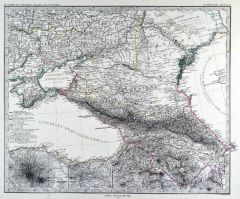 RUSSLAND. - Karte. - Süd-Russland & Kaukasien. Gebietskarte, mit zwei Nebenkarten.
Grenzkol. Kupferstich von Alt und Stichart nach Petermann aus Stieler bei Perthes, Gotha, 1875, 33,5 x 40 cm.
Espenhorst, PP 2.1.1.1.6. - Aus: A. Stieler's "Hand-Atlas" (6. Ausgabe, Auflage 1875). - Zeigt das Gebiet zwischen Schwarzem und ... (Artikelnr. 35386EG)
Erfahren Sie mehr95,00 € Inkl. MwSt. -
RUSSLAND. - Karte. - Süd-Russland & Kaukasien. Gebietskarte, mit zwei Nebenkarten.
Grenzkol. Kupferstich von Alt und Stichart nach Petermann aus Stieler bei Perthes, Gotha, 1867, 33,5 x 40 cm.
Espenhorst, PP 2.1.1.1.4. - Aus: A. Stieler's "Hand-Atlas" (4. Ausgabe, Auflage 1867). - Zeigt das Gebiet zwischen Schwarzem und ... (Artikelnr. 34891EG)
Erfahren Sie mehr110,00 € Inkl. MwSt. -
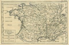 FRANKREICH. - Karte. - Das Alte Gallien und zwar das Narbonische das Lugdunische und Aquitanien. Historische Gesamtkarte.
Kupferstich, Halle, um 1760, 19,5 x 30 cm.
Aus "Übersetzung der Allgemeinen Welthistorie". - Geglättete Längsfalten. (Artikelnr. 35841EG)
Erfahren Sie mehr88,00 € Inkl. MwSt. -
 RUSSLAND. - Karte. - Europaeisches Rußland auch Schweden und Norwegen, dabei: Übersicht des Oesterreichischen und Preussischen Staats.
Grenzkol. Kupferstich aus Stieler bei Perthes, Gotha, dat. 1852, 32,5 x 38,5 cm.
Aus: A. Stieler's "Hand-Atlas". (Artikelnr. 694AG)
Erfahren Sie mehr60,00 € Inkl. MwSt. -
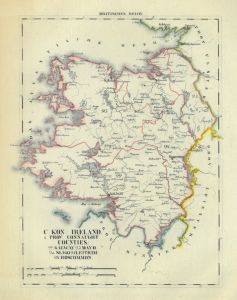
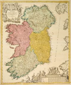 IRLAND. - Karte. - Hiberniae Regnum tam in praecipuas Ultoniae, Connaciae, Laceniae et Momoniae.
Altkol. Kupferstich von Johann Baptist Homann, um 1730, 57 x 48 cm.
Gesamtkarte mit den vier Bezirken. Mit zwei großen dekorativen Kartuschen. - Am oberen Rand links gering gebräunt, sonst wohl erhalten. (Artikelnr. 27604CG)
Erfahren Sie mehr320,00 € Inkl. MwSt. -
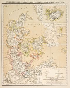
 DÄNEMARK. - Karte. - Das Koenigreich Dänemark mit den Herzogthümern Schleswig, Holstein u. Lauenburg.
Grenzkol. Stahlstich aus Meyer bei BI, um 1865, 37 x 29,5 cm.
Espenhorst, PP 3.4 (Meyer-Ravenstein 1862-1884). - Aus: Joseph Meyer's "Hand-Atlas", redigiert von Ludwig Ravenstein (1838-1915). - Mit zwei Nebenkarten von Kopenhagen und Islan... (Artikelnr. 19270BG)
Erfahren Sie mehr110,00 € Inkl. MwSt. -
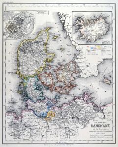
 DÄNEMARK. - Karte. - Königreich Dänemark und die Preussischen Provinzen Schleswig-Holstein und Lauenburg.
Farblithographie aus Sohr-Berghaus bei Flemming, Glogau, um 1885, 40,5 x 33 cm.
Espenhorst, PP 4.1.3. - Aus: Sohr-Berghaus's "Hand-Atlas über alle Teile der Erde". - Mit zwei Nebenkarten von Island und den Föröer Inseln. (Artikelnr. 19481BG)
Erfahren Sie mehr80,00 € Inkl. MwSt. -
 ITALIEN. - Karte. - Italia antiqua. Gesamtkarte mit Korsika und Sardinien zur Zeit des Kaisers Augustus.
Kupferstich von J.G. Beck, 1773, 20,5 x 30,5 cm.
Aus: Christoph Cellarius, "Notitia orbis antiquii sive geographia plenior". - Mit figürlicher Kartusche. (Artikelnr. 19312CG)
Erfahren Sie mehr85,00 € Inkl. MwSt. -
 NIEDERLANDE. - Benelux. - Karte. - Niederlande und Belgien, mit Luxemburg. Mit Nebenkarte "Neue Festung Antwerpen".
Grenzkol. Kupferstich nach Vogel aus Stieler bei Perthes, Gotha, 1875, 40,5 x 32,5 cm.
Espenhorst, PP 2.1.1.1.6. - Aus: A. Stieler's "Hand-Atlas" (6. Ausgabe, Auflage 1875). (Artikelnr. 35373EG)
Erfahren Sie mehr70,00 € Inkl. MwSt. -
 ITALIEN. - Nord- und Mittelitalien. - Karte. - Ober- und Mittel-Italien, bis Terracina bzw. Vasto.
Grenzkol. Kupferstich von Jungmann nach Petermann und Habenicht aus Stieler bei Perthes, Gotha, 1875, 33,5 x 40 cm.
Espenhorst, PP 2.1.1.1.6. - Aus: A. Stieler's "Hand-Atlas" (6. Ausgabe, Auflage 1875). (Artikelnr. 35369EG)
Erfahren Sie mehr85,00 € Inkl. MwSt. -
RUSSLAND. - Karte. - Das Europaeische Russland, bis zum Ural. Mit Umgebungskarte von St. Petersburg.
Grenzkol. Kupferstich nach Weiland, Weimar im Geograph. Institut, dat. 1842, 58 x 46 cm.
Espenhorst, PP 1.1.3. - Zeigt Ostsee, Eismeer, Schwarzes und Kaspisches Meer. Mit Farberklärungen. (Artikelnr. 668FG)
Erfahren Sie mehr138,00 € Inkl. MwSt. -
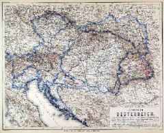 ÖSTERREICH und UNGARN. - Karte. - Kaiserthum Oesterreich. Gesamtkarte des Habsburgerreiches zur Zeit der Doppelmonarchie.
Stahlstich mit Farblithographie nach Ravenstein aus Meyer bei BI, um 1865, 33 x 42 cm.
Espenhorst, PP 3.4 (Meyer-Ravenstein 1862-1884). - Aus: Joseph Meyer's "Hand-Atlas", redigiert von Ludwig Ravenstein (1838-1915). (Artikelnr. 19301BG)
Erfahren Sie mehr120,00 € Inkl. MwSt. -
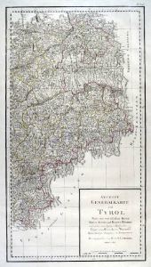 TIROL. - Karte. - Neueste Generalkarte von Tyrol. Nach den vortrefflichen Karten Peter Anichs und Blasius Huebers und andern zuverlässigen Hilfquellen Verfasst von Herrn A. von Wenzely usw. Östliche Hälfte der Tirolkarte.
Kupferstich bei F.A. Schraembl, dat. 1790, 67 x 37 cm.
Aus: "Allgemeiner Grosser Atlas", Nr. 72c. - Zeigt im Osten Bad Tölz, Hall, Brixen, Klausen und das Fleims-Thal, im Norden Neubeuern, im Süden Feltre, im Osten Saalfelden, Zell, Hl. ... (Artikelnr. 35615EG)
Erfahren Sie mehr140,00 € Inkl. MwSt. -
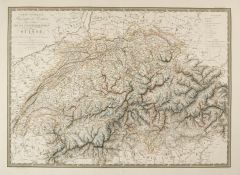
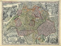 SCHWEIZ. - Karte. - Nova Totis Helvetiae. Gesamtkarte mit 4 Kartuschen (u.a. Ansichten des Rheinfalls und des Rheinursprungs).
Altkol. Kupferstich von Tobias Conrad Lotter bei Seutter, um 1745, 19,5 x 26 cm. (Artikelnr. 978AG)
Erfahren Sie mehr200,00 € Inkl. MwSt. -
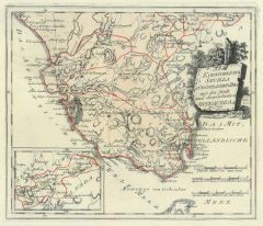 SEVILLA. - Karte. - Des Königreichs Sevilla südöstlicher Theil mit der Stadt und dem Gebiethe Antequera Nro. 545.
Altkol. Kupferstich von Reilly, um 1790, 23 x 27 cm. - Mit kleiner Nebenkarte. (Artikelnr. 24418CG)
Erfahren Sie mehr110,00 € Inkl. MwSt. -
 ITALIEN. - Karte. - Italien in 4 Blättern. Gesamtkarte in 4 Blättern.
4 Kupferstiche mit Farblithographie von Kühn nach Vogel aus Stieler bei Perthes, Gotha, 1891, je 40,5 x 33 cm.
Espenhorst, PP 2.1.1.1.8. - Aus: A. Stieler's "Hand-Atlas" (8. Ausgabe, Auflage 1891). - Zeigt gesamt Italien, mit Sizilien und... (Artikelnr. 19168BG)
Erfahren Sie mehr280,00 € Inkl. MwSt. -
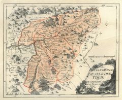
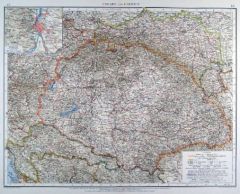
BÖHMEN. - Mähren und Schlesien. - Karte. - Böhmen, Mähren und Österreichisch-Schlesien.
Farblithographie von Ketterer nach Tänzler und Umbreit aus Andree bei Velhagen & Klasing, 1899, 36,5 x 49 cm.
Espenhorst, PP 5.1.4. - Aus: Richard Andree's "Allgemeiner Handatlas" (4. Ausgabe, Auflage 1899). - "Mit dieser Ausgabe wurde de... (Artikelnr. 35000EG)
Erfahren Sie mehr90,00 € Inkl. MwSt. -
SÜDOSTEUROPA. - Karte. - Süd-West-Russland & die Türkei. Gesamtkarte von Südosteuropa.
Grenzkol. Kupferstich nach Habenicht und Petermann aus Stieler bei Perthes, Gotha, 1867, 33 x 40 cm.
Espenhorst, PP 2.1.1.1.4. - Aus: A. Stieler's "Hand-Atlas" (4. Ausgabe, Auflage 1867). - Zeigt im Süden den Golf von Arta bzw. Volos, im ... (Artikelnr. 34886EG)
Erfahren Sie mehr80,00 € Inkl. MwSt. -
 UNGARN. - Karte. - Ungarn und Galizien. Mit Nebenkarte "Budapest und Umgebung".
Farblithographie von Gottschalck nach Brandrup aus Andree bei Velhagen & Klasing, 1899, 38 x 49 cm.
Espenhorst, PP 5.1.4. - Aus: Richard Andree's "Allgemeiner Handatlas" (4. Ausgabe, Auflage 1899). - "Mit dieser Ausgabe wurde der ANDREE zu... (Artikelnr. 35001EG)
Erfahren Sie mehr100,00 € Inkl. MwSt. -
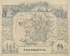 FRANKREICH. - Karte. - Frankreich. Gesamtkarte (11 x 14 cm), umgeben von mehreren Figuren und historischen Szenen.
Grenzkol. Kupferstich bei J. Berlin, 1853, 16 x 20,5 cm.
Espenhorst, PP 63,5. - Im Rand gering unfrisch. (Artikelnr. 26794CG)
Erfahren Sie mehr80,00 € Inkl. MwSt. -
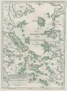 ÄGÄISCHE INSELN. - Karte. - Das Aegaeische Meer heute Der Archipelagus oder das Inselmeer Nro.18.
Grenzkol. Kupferstich von Reilly, um 1790, 32 x 22 cm.
Zeigt die Ägäis zwischen griechischer und türkischer Küste, im Westen Griechenland bis zur Linie Larissa-Theben-Megara-Falera. (Artikelnr. 10348CG)
Erfahren Sie mehr110,00 € Inkl. MwSt. -
RUSSLAND. - Karte. - Carte Générale de L'Empire des Russes et de la Tatarie Universelle. Gesamtkarte.
Grenzkol. Kupferstich von R. de Vaugondy, dat. 1769, 16 x 20,5 cm.
Zeigt das Gebiet von Polen bis zum Pazifik mit Japan, im Südosten China. (Artikelnr. 32539EG)
Erfahren Sie mehr98,00 € Inkl. MwSt.