Suchergebnisse für: "europa karte"
-
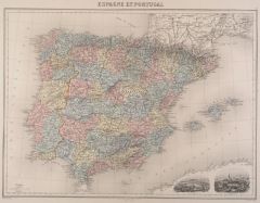 SPANIEN und PORTUGAL. - Karte. - Espagne et Portugal. Gesamtkarte, rechts unten 2 kl. Ansichten von Lissabon und Madrid.
Altkol. Stahlstich von Bixet nach Lecocq, um 1860, 31 x 42 cm. (Artikelnr. 8354CG)
Erfahren Sie mehr58,00 € Inkl. MwSt. -
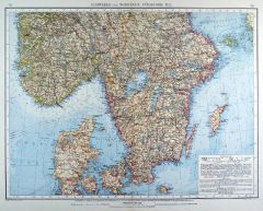 SKANDINAVIEN. - Karte. - Schweden und Norwegen. Südlicher Teil, mit Dänemark.
Farblithographie von Ketterer nach Umbreit aus Andree bei Velhagen & Klasing, 1899, 37,5 x 49,50 cm.
Espenhorst, PP 5.1.4. - Aus: Richard Andree's "Allgemeiner Handatlas" (4. Ausgabe, Auflage 1899). - "Mit dieser Ausgabe wurde der ANDREE z... (Artikelnr. 35018EG)
Erfahren Sie mehr100,00 € Inkl. MwSt. -
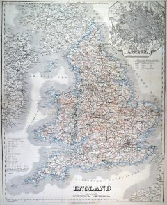 GROSSBRITANNIEN. - England. - Karte. - England. Mit Nebenkarte "London mit seinen nächsten Umgebungen".
Grenzkol. Kupferstich, Weimar im Geograph. Institut, 1872, 63,5 x 51,5 cm.
Espenhorst, PP 1.1.6. - Aus: Heinrich Kiepert's "Grosser Hand-Atlas" (43. Ausgabe, Auflage 1872). - Gewann 1871 die einzige Goldmedaille auf dem Geographenkongreß ... (Artikelnr. 35465EG)
Erfahren Sie mehr110,00 € Inkl. MwSt. -
GROSSBRITANNIEN. - Karte. - Grossbritannien und Ireland. Gesamtkarte mit Shetlandinseln, mit vier Nebenkarten.
Grenzkol. Kupferstich von Jungmann nach Weiland, Weimar im Geograph. Institut, dat. 1835, 63 x 48,5 cm.
Espenhorst, PP 1.1.3. - Die Nebenkarten zeigen: Gibraltar, Kanalinseln, Helgoland, Malta mit Gozzo und Comino. Mit Farbangaben für die... (Artikelnr. 659FG)
Erfahren Sie mehr132,00 € Inkl. MwSt. -
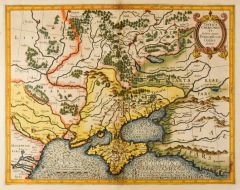 UKRAINE. - Karte. - Taurica Chersonesus VS. Nostra aetate Przecopsca et Gazara dicitur.
Altkol. Kupferstich nach Gerard Mercator, um 1630, 31,5 x 40 cm.
Zeigt die Ukraine mit der Halbinsel Krim, dem Asowschen Meer und dem nördlichen Schwarzen Meer. Oben rechts Titelkartusche, unten links Meilenzeiger, darunter Verlegername u... (Artikelnr. 24739CG)
Erfahren Sie mehr450,00 € Inkl. MwSt. -
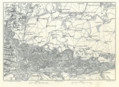 WIEN. - Karte. - Wagram. Kleinteilige Umgebungskarte von Wien, im Norden "Deutsch-Wagram".
Kupferstich von Jacobs nach Duvotenay aus Lavallée bei Furne, Paris, 1858, 14 x 20 cm.
Aus: Théophile Lavallée's "Atlas de Géographie Militaire". - Zeigt im Süden Wien und den Donaulauf von Langen Enzersdorf bis Fischament mit Insel L... (Artikelnr. 34870EG)
Erfahren Sie mehr45,00 € Inkl. MwSt. -
ITALIEN. - Karte. - Italien. Gesamtkarte, mit zwei Plänen (Umgebung von Rom bzw. Neapel).
Altkol. Lithographie von E. Serth bei E. Hochdanz und C. Hoffmann, Stuttgart, 1876, 38,5 x 29 cm.
Espenhorst, PP 21.2.3; aus "Illustrirter Volks-Atlas", nach T. Brommes Handatlas hrg. v. C.G. Reuschle. - Mit Dalmatinischer Küste, Malta un... (Artikelnr. 32912EG)
Erfahren Sie mehr110,00 € Inkl. MwSt. -
GRIECHENLAND. - Karte. - Das Königreich Hellas oder Griechenland und die Jonischen Inseln (Ephtánisos).
Grenzkol. Kupferstich von Herzberg nach Kiepert, Weimar im Geograph. Institut, 1876, 53,5 x 66,5 cm.
Espenhorst, AS, 1.1.6. - Im Norden bis zum Elymbos-Gebirge, im Süden bis Kythera. Mit zwei Nebenkarten: Athen und Umgebung sowie Korfu. ... (Artikelnr. 32596EG)
Erfahren Sie mehr138,00 € Inkl. MwSt. -
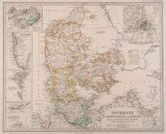 DÄNEMARK. - Karte. - Dänemark mit Schleswig, Holstein u. Lauenburg, nebst den dänischen Colonien.
Grenzkol. Kupferstich von Hanemann nach Petermann aus Stieler bei Perthes, Gotha, dat. 1862, 33,5 x 41 cm.
Aus: A. Stieler's "Hand-Atlas" - Gesamtkarte mit Maßstab und Erklärungen. Mit 5 Nebenkarten von Island, Grönland, die Faroer Ins... (Artikelnr. 18036CG)
Erfahren Sie mehr75,00 € Inkl. MwSt. -
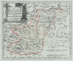
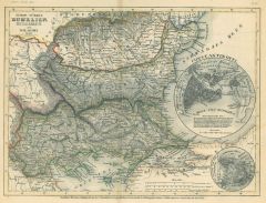
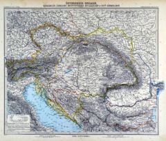 ÖSTERREICH und UNGARN. - Karte. - Österreich-Ungarn. Rumänien, Serbien, Montenegro, Bulgarien & Ost-Rumelien.
Kupferstich mit Farblithographie von Kühn und Messerschmidt aus Stieler bei Perthes, Gotha, 1891, 33 x 40 cm.
Espenhorst, PP 2.1.1.1.8. - Aus: A. Stieler's "Hand-Atlas" (8. Ausgabe, Auflage 1891). - Zeigt Österreich und Ungarn, mit Kroat... (Artikelnr. 19167BG)
Erfahren Sie mehr85,00 € Inkl. MwSt. -
SPANIEN und PORTUGAL. - Karte. - Carte Physique & Politique de L'Espagne et du Portugal.
Grenzkol. Kupferstich von Marlier aus Dussieux bei Lecoffre, dat. 1845, 27,5 x 38,5 cm.
Aus: Louis Dussieux's "Atlas Général de Géographie". - Gesamtkarte der Iberischen Halbinsel, mit den Balearen. - In den Ecken oben leicht wasserrand... (Artikelnr. 34812EG)
Erfahren Sie mehr75,00 € Inkl. MwSt. -
BÖHMEN. - Mähren und Schlesien. - Karte. - Böhmen, Mähren, Schlesien, Ober- und Niederösterreich. Gebietskarte.
Farblithographie nach Wolf aus Spamer, 1902, 31,5 x 41,5 cm.
Espenhorst, PP 23.2. - Aus: O. Spamer's "Grosser Hand-Atlas" (2. Ausgabe, Auflage 1902). - Verso Typographie, mit 9 Gebietskarten. - Unten 2 hinterlegte Randeinrisse, im Kartenbi... (Artikelnr. 35084EG)
Erfahren Sie mehr80,00 € Inkl. MwSt. -
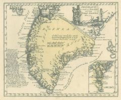
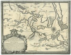 NAKSKOV/Lolland. - Karte. - Ichnographia Nakscoviae muniti Laalandiae. Ansicht der Insel Lolland mit Nakskov als Mittelpunkt.
Kupferstich in gestochenem Rahmen aus Pufendorf, 1696, 24,5 x 31 cm.
Fauser 9469. - Mit Titelkartusche links unten. Auf gestochene Umrandung beschnitten. (Artikelnr. 19567AG)
Erfahren Sie mehr95,00 € Inkl. MwSt. -
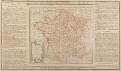 FRANKREICH. - Karte. - La France, divisée en ses quarante Gouvernemens Généraux et Militaires. Gesamtkarte.
Altkol. Kupferstich von Brion de la Tour, 1790, 23 x 26 cm, mit Legende 28 x 48 cm.
Beidseitig montierte Legende, die geographische, statistische und historische Besonderheiten beschreibt. - Kartusche etwas schwach. (Artikelnr. 7669AG)
Erfahren Sie mehr70,00 € Inkl. MwSt. -
ITALIEN. - Mittelitalien. - Karte. - Mittelitalien. Mit einer Nebenkarte "Die Römische Campagna".
Farblithographie nach Scrobel aus Andree bei Velhagen & Klasing, 1900, 37 x 48,5 cm.
Espenhorst, PP 5.1.4. - Aus: Richard Andree's "Allgemeiner Handatlas" (4. Ausgabe, Auflage 1900). - Zeigt Italien ab Florenz, im Süden bis Catanzaro. Im ... (Artikelnr. 739FG)
Erfahren Sie mehr120,00 € Inkl. MwSt. -
TIROL. - Karte. - Südbayern, Tirol und Salzburg, mit Südtirol. Mit Anschlußkarte.
Farblithographie Simon nach Jungk aus Andree bei Velhagen & Klasing, 1899, 36,5 x 48,5 cm.
Espenhorst, PP 5.1.4. - Aus: Richard Andree's "Allgemeiner Handatlas" (4. Ausgabe, Auflage 1899). - "Mit dieser Ausgabe wurde der ANDREE zum führen... (Artikelnr. 34998EG)
Erfahren Sie mehr120,00 € Inkl. MwSt. -
NIEDERLANDE. - Benelux. - Karte. - Carte Physique et Politique de la Holland et de la Belgique.
Grenzkol. Kupferstich von Marlier aus Dussieux bei Lecoffre, dat. 1847, 39 x 27,5 cm.
Aus: Louis Dussieux's "Atlas Général de Géographie". - Zeigt die Benelux-Staaten. (Artikelnr. 34803EG)
Erfahren Sie mehr60,00 € Inkl. MwSt. -
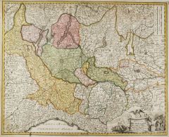 MAILAND. - Karte. - Ducatus Mediolani una cum Confinys accerata Tabula exhibitus auctus et e medatus.
Altkol. Kupferstich von J.B. Homann, um 1720, 47,5x 58 cm.
Zeigt das nordwestliche Italien mit Mailand im Mittelpunkt und den oberitalienischen Seen. Titelkartusche rechts unten. Schönes altes Flächenkolorit. (Artikelnr. 24935CG)
Erfahren Sie mehr300,00 € Inkl. MwSt. -
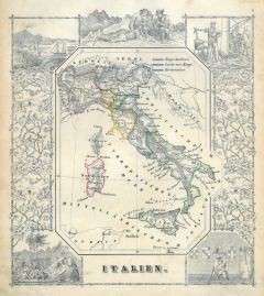 ITALIEN. - Karte. - Italien. Gesamtkarte (19,5 x 17,5 cm), umgeben von mehreren Figuren, Ansichten und historischen Szenen.
Grenzkol. Kupferstich bei J. Berlin, 1853, 16 x 20,5 cm.
Espenhorst, PP 63,5. - Im Rand gering unfrisch. (Artikelnr. 26856CG)
Erfahren Sie mehr120,00 € Inkl. MwSt. -
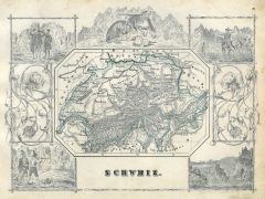 SCHWEIZ. - Karte. - Schweiz. Gesamtkarte (9,5 x 13 cm), umgeben von mehreren Figuren, Tieren und historischen Szenen.
Grenzkol. Kupferstich bei J. Berlin, 1853, 16 x 20,5 cm.
Espenhorst, PP 63,5. - Im Rand gering unfrisch. (Artikelnr. 26800CG)
Erfahren Sie mehr100,00 € Inkl. MwSt. -
GROSSBRITANNIEN. - England. - Karte. - England. Mit Nebenkarte "London mit seinen nächsten Umgebungen".
Grenzkol. Kupferstich, Weimar im Geograph. Institut, 1872, 63,5 x 51,5 cm.
Espenhorst, PP 1.1.6. - Aus: Heinrich Kiepert's "Grosser Hand-Atlas" (43. Ausgabe, Auflage 1872). - Gewann 1871 die einzige Goldmedaille auf dem Geographenkongreß ... (Artikelnr. 32930EG)
Erfahren Sie mehr108,00 € Inkl. MwSt. -
PICARDIE. - Karte. - Praefectura Piccardiae. Die Picardie mit Artois, Flandern und Hennegau.
Altkol. Kupferstich von G. Valck um 1710, 47 x 59,5 cm.
Gebietskarte mit Titelleiste und Meilenzeiger. Im Zentrum die Somme mit Amiens und S. Quentin, im Nordwesten die Atlantikküste von Dünkirchen über Calais bis Dieppe, im Süden Noyo... (Artikelnr. 32236EG)
Erfahren Sie mehr220,00 € Inkl. MwSt. -
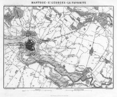 MANTUA. - Karte. - Mantoue - St. Georges - La Favorite. Kleinteilige Umgebungskarte von Mantova.
Kupferstich von Dyonnet nach Duvotenay aus Lavallée bei Furne, Paris, 1858, 20 x 26,5 cm.
Aus: Théophile Lavallée's "Atlas de Géographie Militaire". - Zeigt im Norden Marmirolo und Due Castelli, im Osten Castellaro und Roncoferraro, im... (Artikelnr. 34869EG)
Erfahren Sie mehr95,00 € Inkl. MwSt. -
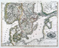 SKANDINAVIEN. - Karte. - Schweden und Norwegen auch Daenemark. Mit Umgebungsplan von Stockholm.
2 grenzkol. Kupferstiche von Edler nach Hübbe aus Stieler bei Perthes, Gotha, dat. 1824, je 28,5 x 36,5 cm.
Espenhorst, PP 2.1.1.1.0.b. - Aus: A. Stieler's "Hand-Atlas" ("Initial Version Expanded through Supplements"). - Zeigt im Osten Fi... (Artikelnr. 33219EG)
Erfahren Sie mehr140,00 € Inkl. MwSt. -
 BALKAN. - Karte. - Europ. Türkei: Rumelien, Bulgarien und Walachei 1850 mit zwei Nebenkarten: Konstantinopel und die Straße von Konstantinopel.
Grenzkol. Stahlstich aus Meyer's Zeitungsatlas, 1853, 18 x 24,5 cm. (Artikelnr. 984BG)
Erfahren Sie mehr35,00 € Inkl. MwSt. -
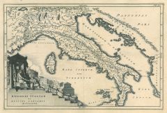 ITALIEN. - Karte. - Regiones Italiae ex Augusti Caesaris divisione. Historische Gesamtkarte zur Zeit des Kaisers Augustus.
Kupferstich von J.G. Beck, 1773, 20,5 x 30,5 cm.
Aus: Christoph Cellarius, "Notitia orbis antiquii sive geographia plenior". - Mit figürlicher Kartusche. (Artikelnr. 19303CG)
Erfahren Sie mehr75,00 € Inkl. MwSt. -
SAMOS. - Karte. - Carte détaillée de la route de l'auteur depuis le méandre jusqu'au Golfe d'Adramytti.
Kupferstich von Perrier nach Kauffer, um 1780, 33 x 22 cm.
Zeigt die Westküste der Türkei und die Inseln Lesbos, Chios und Samos. (Artikelnr. 13978AG)
Erfahren Sie mehr170,00 € Inkl. MwSt. -
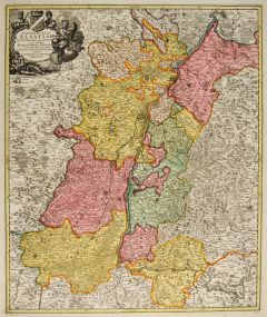 ELSASS. - Karte. - Landgraviatus Alsatiae tam Superioris quam Infer. cum utroque Marchionatu Badense.
Altkol. Kupferstich von J.B. Homann, um 1720, 58 x 48 cm.
Zeigt das Gebiet von Bitsch über Dieu bis Tellsberg, und von Eglisau am Rhein über Sultz nach Landau. Mit figürlicher Kartusche links oben. - Schönes altes Flächenkolorit. (Artikelnr. 27413CG)
Erfahren Sie mehr220,00 € Inkl. MwSt. -
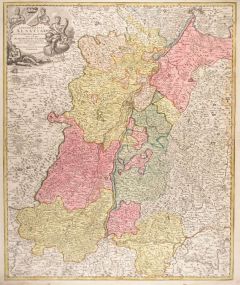 ELSASS. - Karte. - Landgraviatus Alsatiae tam Superioris quam Infer. cum utroque Marchionatu Badense.
Altkol. Kupferstich von J.B. Homann, um 1720, 58 x 48 cm.
Zeigt das Gebiet von Bitsch über Dieu bis Tellsberg, und von Eglisau am Rhein über Sultz nach Landau. Mit figürlicher Kartusche links oben. - Am rechten Rand gering wasserrandig. (Artikelnr. 5319AG)
Erfahren Sie mehr180,00 € Inkl. MwSt. -
FRANKREICH. - Karte. - Gesamtkarte in vier Teilen. Insgesamt vier Darstellungen auf vier Blättern.
4 Farblithographien nach Wolf aus Spamer, 1902, je 31,5 x 41,5 cm.
Espenhorst, PP 23.2. - Aus: O. Spamer's "Grosser Hand-Atlas" (2. Ausgabe, Auflage 1902). - Mit insgesamt 3 Nebenkarten: Korsika, Seine-Mündung und Umgebung von Paris. - Ve... (Artikelnr. 35094EG)
Erfahren Sie mehr180,00 € Inkl. MwSt. -
NIEDERLANDE. - Benelux. - Karte. - Die Niederlande und Belgien, mit Luxemburg. Gesamtkarte der Beneluxstaaten.
Grenzkol. Kupferstich von Eulenstein nach Kiepert, Weimar im Geograph. Institut, 1872, 61 x 49,5 cm.
Espenhorst, PP 1.1.6. - Aus: Heinrich Kiepert's "Grosser Hand-Atlas" (43. Ausgabe, Auflage 1872). - Gewann 1871 die einzige Goldmedaille a... (Artikelnr. 32931EG)
Erfahren Sie mehr102,00 € Inkl. MwSt. -
GROSSBRITANNIEN. - England. - Karte. - England. Gesamtkarte mit Wales, rechts oben Umgebungsplan von London.
Grenzkol. Kupferstich nach Kiepert und Gräf, Weimar im Geograph. Institut, dat. 1856, 64,5 x 51 cm.
Espenhorst, PP 1.1.5. - Aus: Heinrich Kiepert's "Hand-Atlas" (42. Ausgabe, 1856/69). - Zeigt im Westen die Irische Ostküste, im Osten die... (Artikelnr. 33156EG)
Erfahren Sie mehr120,00 € Inkl. MwSt. -
ITALIEN. - Norditalien. - Karte. - Nördliches Italien. Gebietskarte, mit Umgebungskarten von Venedig und Rom.
Grenzkol. Kupferstich nach Weiland, Weimar im Geograph. Institut, dat. 1841, 46 x 61 cm.
Espenhorst, PP 1.1.3. - Zeigt das Gebiet von Bozen im Norden bis Gaeta im Süden, dazu Korsika und Dalmatien bis Coronata. - Unten wasserrandig bis in... (Artikelnr. 655FG)
Erfahren Sie mehr112,00 € Inkl. MwSt. -
SPANIEN und PORTUGAL. - Karte. - Spanien und Portugal, mit Balearen. Mit drei Nebenkarten.
Farblithographie nach Scrobel aus Andree bei Velhagen & Klasing, 1900, 36,5 x 47,50 cm.
Espenhorst, PP 5.1.4. - Aus: Richard Andree's "Allgemeiner Handatlas" (4. Ausgabe, Auflage 1900). - Im Süden die Nordafrikanische Küste zwischen El A... (Artikelnr. 738FG)
Erfahren Sie mehr120,00 € Inkl. MwSt. -
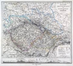 BÖHMEN. - Mähren und Schlesien. - Karte. - Östliches Deutschland oder Böhmen, Mähren und Schlesien.
Grenzkol. Kupferstich von Alt und Jungmann nach Berghaus aus Stieler bei Perthes, Gotha, 1875, 30,5 x 34,5 cm.
Espenhorst, PP 2.1.1.1.6. - Aus: A. Stieler's "Hand-Atlas" (6. Ausgabe, Auflage 1875). - Im Unterrand eine Höhenkarte von Münc... (Artikelnr. 35365EG)
Erfahren Sie mehr85,00 € Inkl. MwSt. -
MÄHREN. - Karte. - Die Markgrafschaft Mähren und das Herzogthum Ober u. Nieder-Schlesien.
Grenzkol. Kupferstich von Geyer und Hensgen nach Gräf, Weimar im Geograph. Institut, um 1860, 44 x 56 cm.
Espenhorst, PP 1.1.5. - Aus: Heinrich Kiepert's "Hand-Atlas" (42. Ausgabe, 1856/69). - Zeigt im Norden Strehlen, im Osten Bielitz, i... (Artikelnr. 35502EG)
Erfahren Sie mehr110,00 € Inkl. MwSt. -
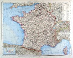 FRANKREICH. - Karte. - Übersichtskarte von Frankreich, mit Korsika. Mit einer Nebenkarte.
Farblithographie nach Scrobel aus Andree bei Velhagen & Klasing, 1899, 36,5 x 46,5 cm.
Espenhorst, PP 5.1.4. - Aus: Richard Andree's "Allgemeiner Handatlas" (4. Ausgabe, Auflage 1899). - "Mit dieser Ausgabe wurde der ANDREE zum führenden ... (Artikelnr. 35005EG)
Erfahren Sie mehr60,00 € Inkl. MwSt. -
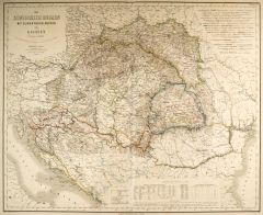 UNGARN. - Karte. - Das Königreich Ungarn mit seinen Nebenländern und Galizien.
Grenzkol. Kupferstich von Geyer und Luther nach Gräf, Weimar im Geograph. Institut, 1872, 51 x 64,5 cm.
Espenhorst, PP 1.1.6. - Aus: Heinrich Kiepert's "Grosser Hand-Atlas" (43. Ausgabe, Auflage 1872). - Gewann 1871 die einzige Goldmedail... (Artikelnr. 35518EG)
Erfahren Sie mehr110,00 € Inkl. MwSt. -
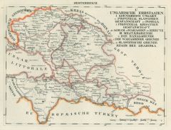 JUGOSLAWIEN. - Karte. - Provinzial Slavonien. Gespanschaft Posega, Provinzial Kroatien. Gespantschaft Agram, Warasdin, Kreutz, Militärgrenze: Warashdiner Grenze, Slawonische Grenze.
Grenzkol. Lithographie bei Schlieben, 1829, 19 x 26 cm.
Gebietskarte zwischen Warashdin, Zagreb und Brod, Posega. (Artikelnr. 18754AG)
Erfahren Sie mehr65,00 € Inkl. MwSt. -
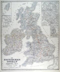 GROSSBRITANNIEN. - Karte. - Die Britischen Inseln oder die Vereinigten Königreiche Grossbritannien und Ireland. Gesamtkarte.
Grenzkol. Kupferstich von Kraatz nach Kiepert, Weimar im Geograph. Institut, 1876, 61 x 51 cm.
Espenhorst, AS, 1.1.6. - Mit vier Nebenkarten: Shetlandinseln, Normannische (=Kanal) Inseln, Fabrikdistricte im nordwestlichen England und Kohle... (Artikelnr. 32607EG)
Erfahren Sie mehr95,00 € Inkl. MwSt. -
ÖSTERREICH und UNGARN. - Karte. - Übersichtskarte von Österreich-Ungarn. Mit Nebenkarte "Wien und Umgebung".
Farblithographie nach Scrobel aus Andree bei Velhagen & Klasing, 1900, 37 x 46,5 cm.
Espenhorst, PP 5.1.4. - Aus: Richard Andree's "Allgemeiner Handatlas" (4. Ausgabe, Auflage 1900). - Zeigt alle Länder der Österreichisch-Ungarischen Mon... (Artikelnr. 720FG)
Erfahren Sie mehr110,00 € Inkl. MwSt. -
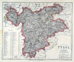 TIROL. - Karte. - Die gefürstete Grafschaft Tyrol nebst Vorarlberg u. dem souver. Fürstenthume Liechtenstein.
Grenzkol. Stahlstich nach Radefeld aus Meyer bei BI, um 1865, 29 x 35,5 cm.
Espenhorst, PP 3.4 (Meyer-Ravenstein 1862-1884). - Aus: Joseph Meyer's "Hand-Atlas", redigiert von Ludwig Ravenstein (1838-1915). - Mit einer Erklärung zu den "H?... (Artikelnr. 19276BG)
Erfahren Sie mehr140,00 € Inkl. MwSt. -
SKANDINAVIEN. - Karte. - Norwège Suède et Danmark. Gesamtkarte, mit Nebenkarten "Islande" und "Iles Faeroer".
Grenzkol. Kupferstich aus Delamarche, dat. 1833, 27,5 x 28,5 cm.
Aus: Felix Delamarche's "Atlas de la Géographie ancienne, du moyen-age et moderne". - Der Ingenieur und Mechaniker für Erd- und Himmelsgloben übernahm 1811 das Atlantenges... (Artikelnr. 34826EG)
Erfahren Sie mehr75,00 € Inkl. MwSt. -
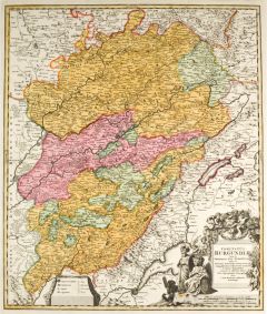 BURGUND. - Karte. - Comitatus Burgundiae tam in Primarias ejus Praefectura quam in Minores earundem Balliviat.
Altkol. Kupferstich von Johann Baptist Homann, um 1716, 56,5 x 47,5 cm.
Flächenkolorierte Gesamtkarte von Burgund. - Große figürliche Titelkartusche rechts unten. - Kräftiger Abdruck und schönes Altkolorit! (Artikelnr. 14860BG)
Erfahren Sie mehr240,00 € Inkl. MwSt. -
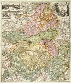 CHAMPAGNE. - Karte. - Tabula Geographica Campaniae specialis in suas sic dictas Electiones accurate distineta edita.
Altkol. Kupferstich von Johann Baptist Homann, um 1710, 57 x 48 cm.
Flächenkolorierte Gesamtkarte der Champagne. Mit figürlicher Kartusche rechts oben und zwei Gesamtansichten von Reims und Troyes links oben. (Artikelnr. 14861BG)
Erfahren Sie mehr200,00 € Inkl. MwSt. -
FRANKREICH. - Karte. - Frankreich und Umgebungen von Paris. Gesamtkarte mit Korsika, dazu Umgebungsplan von Paris.
Grenzkol. Kupferstich von J.C. Ausfeld bei Perthes, Gotha, dat. 1829, 30 x 35,5 cm.
Espenhorst, PP 2.1.1.1.0.b; aus Stielers "Hand-Atlas", Zero Edition. - Mit grenzkol. Einteilung nach Departements. - Gering fleckig. (Artikelnr. 33195EG)
Erfahren Sie mehr98,00 € Inkl. MwSt. -
GROSSBRITANNIEN. - Karte. - Carte Physique & Politique du Royaume-Uni de la Grande-Bretagne et D'Irlande.
Grenzkol. Kupferstich von Marlier aus Dussieux bei Lecoffre, dat. 1847, 38,5 x 27,5 cm.
Aus: Louis Dussieux's "Atlas Général de Géographie". - Gesamtkarte, mit Nebenkarte "Isles Shetland". - Im Rand gering fleckig. (Artikelnr. 34809EG)
Erfahren Sie mehr70,00 € Inkl. MwSt.