Suchergebnisse für: "europa karte"
-
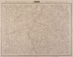
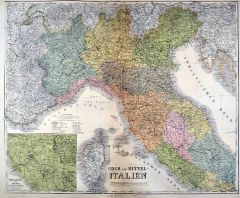 ITALIEN. - Nord- und Mittelitalien. - Karte. - Ober und Mittel-Italien. Mit Nebenkarte "Umgebung von Rom".
Kupferstich mit Farblithographie nach Kiepert, Weimar im Geograph. Institut, 1886, 52 x 63 cm.
Espenhorst, PP 1.1.6. - Aus: Heinrich Kiepert's "Grosser Hand-Atlas" (49. Ausgabe, Auflage 1886). - Zeigt im Süden Gaeta und Benevent. (Artikelnr. 35159EG)
Erfahren Sie mehr120,00 € Inkl. MwSt. -
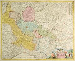 MAILAND. - Karte. - Ducatus Mediolani una cum Confinys accerata Tabula exhibitus auctus et e medatus.
Altkol. Kupferstich von J.B. Homann, um 1720, 47,5x 58 cm.
Zeigt das nordwestliche Italien mit Mailand im Mittelpunkt und den oberitalienischen Seen. - Hübsch kolorierte Titelkartusche rechts unten. Altes Flächenkolorit. (Artikelnr. 27434CG)
Erfahren Sie mehr280,00 € Inkl. MwSt. -
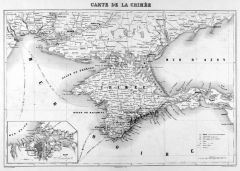 KRIM. - Karte. - Carte de la Crimée. Die Halbinsel, mit Nebenkarte der Umgebung von Sévastopol.
Kupferstich von Jacobs & Barthelemier nach Vuillemin bei Chardon bzw. Furne, Paris, um 1865, 27,5 x 41 cm.
Aus "Atlas de Géographie Militaire". - Im Norden die Küste von Odessa bis Berdiansk. (Artikelnr. 34792EG)
Erfahren Sie mehr75,00 € Inkl. MwSt. -
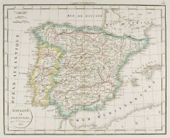
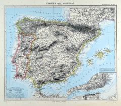
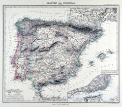 SPANIEN und PORTUGAL. - Karte. - Spanien und Portugal. Gesamtkarte, mit Balearen und Nebenkarte (Umgebung von Lissabon).
Grenzkol. Kupferstich von Weiler nach Vogel aus Stieler bei Perthes, Gotha, 1875, 30,5 x 37 cm.
Espenhorst, PP 2.1.1.1.6. - Aus: A. Stieler's "Hand-Atlas" (6. Ausgabe, Auflage 1875). (Artikelnr. 34878EG)
Erfahren Sie mehr80,00 € Inkl. MwSt. -
GRIECHENLAND. - Karte. - Königreich Griechenland und die Jonischen Inseln. Mit zwei Plänen.
Grenzkol. Kupferstich von Eulenstein nach Stülpnagel und Berghaus aus Stieler bei Perthes, Gotha, 1866, 31 x 41 cm.
Espenhorst, PP 2.1.1.1.4. - Aus: A. Stieler's "Hand-Atlas" (4. Ausgabe, Auflage 1866). - Zeigt im Nordwesten Korfu, im Nor... (Artikelnr. 34908EG)
Erfahren Sie mehr85,00 € Inkl. MwSt. -
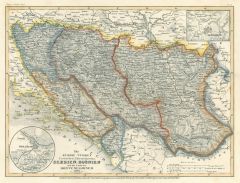 JUGOSLAWIEN. - Karte. - Die Europ. Türkei: Croatien, Herzegovina, Serbien, Bosnien, und das Land der Montenegriner 1849 mit Plan von Belgrad.
Grenzkol. Stahlstich aus Meyer's Zeitungsatlas, 1853, 18 x 24 cm. (Artikelnr. 1125BG)
Erfahren Sie mehr45,00 € Inkl. MwSt. -
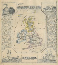 GROSSBRITANNIEN. - Karte. - England, Schottland u. Irland. Gesamtkarte (13,5 x 11 cm), umgeben von Eisenbahn-, Segelschiff- und Dampfschiffdarstellungen.
Grenzkol. Kupferstich bei J. Berlin, 1853, 16 x 20,5 cm.
Espenhorst, PP 63,5. - Im Rand gering unfrisch. (Artikelnr. 27134CG)
Erfahren Sie mehr120,00 € Inkl. MwSt. -
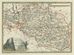 POLEN. - Karte. - Der königlichen Republik Polen Woiwodschaften Chelm u. Wolhynien oder Klein-Polens mittlerer Theil Nro. 44.
Grenzkol. Kupferstich von Reilly, um 1790, 21 x 28,5 cm.
Gebiet zwischen Tarnower, Dukler-, Samborer- und Lemberger Kreis. (Artikelnr. 17727AG)
Erfahren Sie mehr110,00 € Inkl. MwSt. -
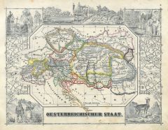 ÖSTERREICH. - Karte. - Oesterreichischer Staat. Gesamtkarte (11 x 15 cm), umgeben von mehreren Figuren, Tieren und historischen Szenen.
Grenzkol. Kupferstich bei J. Berlin, 1853, 16 x 20,5 cm.
Espenhorst, PP 63,5. - Im Rand gering unfrisch. (Artikelnr. 26799CG)
Erfahren Sie mehr100,00 € Inkl. MwSt. -
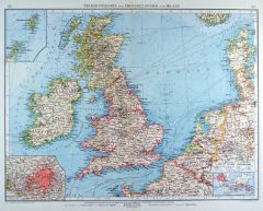 GROSSBRITANNIEN. - Karte. - Übersichtskarte von Grossbritannien und Irland. Mit drei Nebenkarten.
Farblithographie von Franke nach Jungk aus Andree bei Velhagen & Klasing, 1899, 37,5 x 50 cm.
Espenhorst, PP 5.1.4. - Aus: Richard Andree's "Allgemeiner Handatlas" (4. Ausgabe, Auflage 1899). - "Mit dieser Ausgabe wurde der ANDREE zum füh... (Artikelnr. 35011EG)
Erfahren Sie mehr90,00 € Inkl. MwSt. -
FRANKREICH. - Karte. - Frankreich, Physische Übersicht, mit Nebenkarte Korsika und drei Nebenkarten von Frankreich.
Farblithographie nach Wolf aus Spamer, 1902, 31,5 x 41,5 cm.
Espenhorst, PP 23.2. - Aus: O. Spamer's "Grosser Hand-Atlas" (2. Ausgabe, Auflage 1902). - Die drei Nebenkarten zeigen Stromgebiete, Klima und Ackerbau von Frankreich. - Verso Ty... (Artikelnr. 35092EG)
Erfahren Sie mehr70,00 € Inkl. MwSt. -
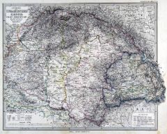
ÖSTERREICH und UNGARN. - Karte. - Der Österreichische Kaiserstaat, mit allen Kronländern. Mit Nebenkarte "Wien".
Grenzkol. Kupferstich nach Vogel aus Stieler bei Perthes, Gotha, 1867, 33 x 40 cm.
Espenhorst, PP 2.1.1.1.4. - Aus: A. Stieler's "Hand-Atlas" (4. Ausgabe, Auflage 1867). - Zeigt das Gebiet von Sachsen und Schlesien bis Albanien, von Veneti... (Artikelnr. 34884EG)
Erfahren Sie mehr90,00 € Inkl. MwSt. -
SKANDINAVIEN. - Karte. - Norwegen, Schweden & Finnland. Gebietskarte von Nordskandinavien (mit Nordschweden). Mit zwei Nebenkarten.
Grenzkol. Kupferstich von Poppey und Jungmann nach Petermann aus Stieler bei Perthes, Gotha, 1867, 34 x 42 cm.
Espenhorst, PP 2.1.1.1.4. - Aus: A. Stieler's "Hand-Atlas" (4. Ausgabe, Auflage 1867). - Die Nebenkarten zeigen die Umgebung von... (Artikelnr. 34887EG)
Erfahren Sie mehr90,00 € Inkl. MwSt. -
 KASTILIEN. - Karte. - La Castille propre ou Vieille, et la Nouvelle; avec L'Estremadure Castillane.
Kupferstich von Nicolas Visscher nach Rodrigo Mendes Silva, um 1690, 44 x 75 cm (von zwei Platten gedruckt).
Zeigt Kastilien mit Madrid im Mittelpunkt und reicht von Salamanca, Alcantara und Badajoz bis zum Mittelmer mit Alicante, Valencia... (Artikelnr. 2676GG)
Erfahren Sie mehr450,00 € Inkl. MwSt. -
SPANIEN und PORTUGAL. - Karte. - Gesamtkarte der Iberischen Halbinsel, mit Balearen, Ibiza, Tanger und Ceuta.
Grenzkol. Kupferstich nach Weiland, Weimar im Geograph. Institut, dat. 1838, 48 x 59,5 cm.
Espenhorst, PP 1.1.3. - Mit vier Umgebungskarten: Gibraltar, Lissabon, Cadiz und Madrid. - Unten schwach wasserrandig bis in die Darstellung. (Artikelnr. 658FG)
Erfahren Sie mehr142,00 € Inkl. MwSt. -
SPANIEN und PORTUGAL. - Karte. - Spanien und Portugal. Gesamtkarte der Iberischen Halbinsel, mit den Balearen.
Grenzkol. Kupferstich von Poppey nach Stülpnagel und Berghaus aus Stieler bei Perthes, Gotha, 1866, 31 x 36,5 cm.
Espenhorst, PP 2.1.1.1.4. - Aus: A. Stieler's "Hand-Atlas" (4. Ausgabe, Auflage 1866). - Mittelbug verso verstärkt. (Artikelnr. 34897EG)
Erfahren Sie mehr85,00 € Inkl. MwSt. -
 UNGARN. - Karte. - Länder der Ungarischen Krone: Ungarn, Siebenbürgen, Slavonien und ein Theil von Kroatien.
Grenzkol. Kupferstich von Alt und Jungmann aus Stieler bei Perthes, Gotha, 1875, 33,5 x 40,5 cm.
Espenhorst, PP 2.1.1.1.6. - Aus: A. Stieler's "Hand-Atlas" (6. Ausgabe, Auflage 1875). - Im Rand leicht fleckig und kleine, hinterlegte Einris... (Artikelnr. 35367EG)
Erfahren Sie mehr85,00 € Inkl. MwSt. -
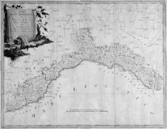 GENUA. - Karte. - Gebietskarte der Mittelmeerküste von Genua bis Ventimiglia im Westen und La Spezia im Osten.
Grenzkol. Kupferstich von G. Zuliani bei A. Zatta, Venedig, dat. 1782, 31 x 41 cm.
Links oben kolorierte Kartusche. - Im Ganzen etwas gebräunt. (Artikelnr. 38592EG)
Erfahren Sie mehr120,00 € Inkl. MwSt. -
SLOWENIEN. - Karte. - Nieder- und Ober-Österreich, Steiermark, Kärnten, Krain und Küstenland, mit Salzburg, Triest und Fiume.
Farblithographie nach Scrobel aus Andree bei Velhagen & Klasing, 1900, 49,5 x 37,5 cm.
Espenhorst, PP 5.1.4. - Aus: Richard Andree's "Allgemeiner Handatlas" (4. Ausgabe, Auflage 1900). (Artikelnr. 723FG)
Erfahren Sie mehr100,00 € Inkl. MwSt. -
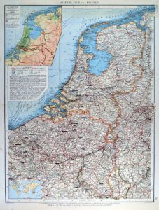
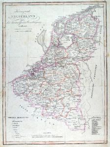 NIEDERLANDE. - Benelux. - Karte. - Königreich Niederland nach der letzten Grenz-Berichtigung verfaßt, oben Inschrift, unten Erklärungen.
Grenzkol. Kupferstich bei T. Mollo, Wien, um 1820, 44,5 x 32 cm.
Gesamtkarte. Das Grenzkolorit zeigt das Königreich der Niederlande inklusive Belgien und Luxemburg, eingeteilt in die Provinzen 1. bis 18. (Artikelnr. 599FG)
Erfahren Sie mehr130,00 € Inkl. MwSt. -
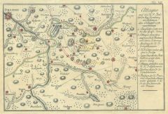 BÖHMEN. - Karte. - Attaque auf die K.K. Batterien bey Romburg in Böhmen den 1ten August 1778.
Altkol. Kupferstich, 1778, 20 x 30 cm.
Aus J.C. Adelungs "Schauplatz des Bayerischen Erbfolgekrieges". - Zeigt das Gebiet zwischen Dresden, Zittau, Böhmisch-Aicha und Aussig; mit Einzeichnung der Truppenstellungen. Faltspuren. (Artikelnr. 17863CG)
Erfahren Sie mehr95,00 € Inkl. MwSt. -
SKANDINAVIEN. - Karte. - Schweden & Norwegen (nördliche Hälfte). Gebietskarte, mit Nordfinnland.
Grenzkol. Farblithographie nach L. Ewald bei Jonghaus & Venator, Darmstadt, um 1865/68, 33,5 x 42 cm.
Neue Auflage, revidirt von Dr. F. Schäffer, 1861; oben rechts: "Ewald's Handatlas Nr. 59"; Espenhorst, PP 19.1.3. - "Der Darmstädter Ha... (Artikelnr. 34740EG)
Erfahren Sie mehr120,00 € Inkl. MwSt. -
 FRANKREICH. - Nordfrankreich. - Karte. - Frankreich. Nördliche Hälfte. Mit Anschluß- und Nebenkarte.
Farblithographie nach Scrobel aus Andree bei Velhagen & Klasing, 1899, 36,5 x 45,5 cm.
Espenhorst, PP 5.1.4. - Aus: Richard Andree's "Allgemeiner Handatlas" (4. Ausgabe, Auflage 1899). - "Mit dieser Ausgabe wurde der ANDREE zum führenden ... (Artikelnr. 35006EG)
Erfahren Sie mehr90,00 € Inkl. MwSt. -
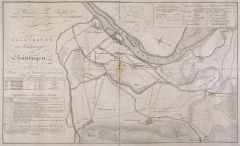 HÜNINGEN. - Karte. - Belagerung des Brückenkopfes von Hüningen im Jahre 1797.
Kupferstich von Ponheimer nach Höhm, um 1814, 31 x 51 cm.
Aus "Erzherzog Karl, Grundsätze der Strategie. Erläutert durch die Darstellung des Feldzugs 1796". - Die nicht genordete Schlachtenkarte zeigt den Rhein im Norden mit Hüningen a... (Artikelnr. 17049AG)
Erfahren Sie mehr140,00 € Inkl. MwSt. -
 PRZIBRAM. - Karte. - Gebietskarte östlich von Przibram zwischen Rosental und Tabor, Miltschin, Bistriz und Networzitz, mittig die Moldau.
Kupferstich, Weimar im Geograph. Institut, 1807, 30,5 x 40,5 cm.
Sehr detaillierte Sektionskarte (124), auch mit kleinsten Orten, Gewässern und Bergen. (Artikelnr. 15374AG)
Erfahren Sie mehr85,00 € Inkl. MwSt. -
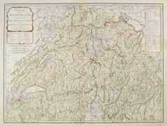 SCHWEIZ. - Karte. - A New Map of Switzerland, divided into the thirteen Cantons with their Allies & their Subjects.
Kupferstich bei Robert Sayer, London, dat. 1790, 49 x 64,5 cm.
Grenzkolorierte Gesamtkarte der Schweiz. - Die Ränder minimal fleckig. (Artikelnr. 2419GG)
Erfahren Sie mehr340,00 € Inkl. MwSt. -
 NIEDERLANDE. - Benelux. - Karte. - Niederlande und Belgien, mit Luxemburg. Mit zwei Nebenkarten.
Farblithographie von Klug nach Sternkopf aus Andree bei Velhagen & Klasing, 1899, 49,5 x 37,5 cm.
Espenhorst, PP 5.1.4. - Aus: Richard Andree's "Allgemeiner Handatlas" (4. Ausgabe, Auflage 1899). - "Mit dieser Ausgabe wurde der ANDREE zum ... (Artikelnr. 35004EG)
Erfahren Sie mehr75,00 € Inkl. MwSt. -
 GROSSBRITANNIEN. - Karte. - Grossbritannien südlicher Theil und "Grossbritannien nördlicher Theil". Gesamtkarte in zwei Blättern.
2 Kupferstiche mit Farblithographie von Poppey nach Petermann aus Stieler bei Perthes, Gotha, 1891, je 33 x 40 cm.
Espenhorst, PP 2.1.1.1.8. - Aus: A. Stieler's "Hand-Atlas" (8. Ausgabe, Auflage 1891). - Mit 5 Nebenkarten von London, Edinb... (Artikelnr. 19175BG)
Erfahren Sie mehr150,00 € Inkl. MwSt. -
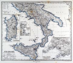 ITALIEN. - Süditalien. - Karte. - Süd-Italien, ab der Linie Rom - Termoli. Mit vier Nebenkarten.
Grenzkol. Kupferstich von Jungmann nach Petermann und Habenicht aus Stieler bei Perthes, Gotha, 1875, 33 x 40 cm.
Espenhorst, PP 2.1.1.1.6. - Aus: A. Stieler's "Hand-Atlas" (6. Ausgabe, Auflage 1875). - Die Nebenkarten zeigen: Sardinien, N... (Artikelnr. 35370EG)
Erfahren Sie mehr80,00 € Inkl. MwSt. -
RUSSLAND. - Asiatischer Teil. - Karte. - Das Russische Asien (Sibirien und Turan). Gesamtkarte von Russland.
Farblithographie nach Wolf aus Spamer, 1902, 31,5 x 41,5 cm.
Espenhorst, PP 23.2. - Aus: O. Spamer's "Grosser Hand-Atlas" (2. Ausgabe, Auflage 1902). - Zeigt das Gebiet von Skandinavien und der Deutschen Grenze bis zur Berings-Straße, im ... (Artikelnr. 35107EG)
Erfahren Sie mehr100,00 € Inkl. MwSt. -
RUSSLAND. - Karte. - Campagne de Russie 1812. Der Zug Napoleons nach Rußland, mit Nebenkarte.
Kupferstich von Jacobs nach Lemud aus Lavallée bei Furne, Paris, 1858, 20,5 x 32 cm.
Aus: Théophile Lavallée's "Atlas de Géographie Militaire". - Zeigt im Norden Pleskau (Pskow), im Süden Krakau und Kiew, im Westen Kalisch, im Osten M... (Artikelnr. 34864EG)
Erfahren Sie mehr50,00 € Inkl. MwSt. -
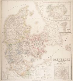 DÄNEMARK. - Karte. - Daenemark, Island, die Far-oer und die Herzogthümer Schleswig, Holstein & Lauenburg.
Grenzkol. Kupferstich von Haubold nach Gräf, Weimar im Geograph. Institut, dat. 1858, 61 x 55 cm.
Espenhorst, PP 1.1.5. - Aus: Kiepert, "Hand-Atlas", 42. Ausgabe (1856/69). - Gesamtkarte mit Maßstab und Erklärungen. Mit drei Nebenkarte... (Artikelnr. 8355CG)
Erfahren Sie mehr95,00 € Inkl. MwSt. -
SKANDINAVIEN. - Karte. - Schweden und Norwegen oder Scandinavische Halbinsel, Königr. Daenemark. Gesamtkarte mit Dänemark.
Farblithographie aus J.M. Ziegler bei J. Wurster, Winterthur, 1864, 56 x 42 cm.
Espenhorst, PP 65.1. - Aus: Jakob Melchior Ziegler's "Geographischer Atlas über alle Theile der Erde" (2. Auflage von 1864). - Links oben eine Insetkarte von ... (Artikelnr. 18991BG)
Erfahren Sie mehr160,00 € Inkl. MwSt. -
FRANKREICH. - Karte. - Frankreich. Gesamtkarte, mit einer Nebenkarte und einem Plan von Paris und Umgebung.
Altkol. Lithographie von Serth bei Hochdanz und Hoffmann, Stuttgart, 1875, 28,5 x 37,5 cm.
Espenhorst, PP 21.2.3. - Aus: "Illustrirter Volks-Atlas" nach T. Brommes Handatlas hrsg. von C.G. Reuschle. - Die Nebenkarte zeigt Korsika. Mit den ... (Artikelnr. 32915EG)
Erfahren Sie mehr58,00 € Inkl. MwSt. -
ITALIEN. - Nord- und Mittelitalien. - Karte. - Ober und Mittel-Italien. Gebietskarte, mit Umgebungskarte von Rom.
Grenzkol. Kupferstich von Mädel/Weiler nach Kiepert/Gräf, Weimar im Geograph. Institut, dat. 1857, 51 x 63 cm.
Espenhorst, PP 1.1.5. - Zeigt das Gebiet von Brixen im Norden bis Gaeta im Süden, im Westen Korsika, im Osten Kroatien bis Ja... (Artikelnr. 33151EG)
Erfahren Sie mehr112,00 € Inkl. MwSt. -
ITALIEN. - Süditalien. - Karte. - Unter Italien oder das Königreich beider Sicilien. Gebietskarte, mit zwei Nebenkarten.
Grenzkol. Kupferstich von Haubold nach Kiepert/Gräf, Weimar im Geograph. Institut, dat. 1857, 59,5 x 51 cm.
Espenhorst, PP 1.1.5. - Die Nebenkarten zeigen "Campagna Felice oder Umgebungen von Neapel", mit Capri, Ischia und Amalfiküste, u... (Artikelnr. 33152EG)
Erfahren Sie mehr132,00 € Inkl. MwSt. -
 SPANIEN und PORTUGAL. - Karte. - Espagne et Potugal. Gesamtkarte der Iberischen Halbinsel, mit den Balearen.
Grenzkol. Kupferstich aus Delamarche, dat. 1833, 26,5 x 33 cm.
Aus: Felix Delamarche's "Atlas de la Géographie ancienne, du moyen-age et moderne". - Der Ingenieur und Mechaniker für Erd- und Himmelsgloben übernahm 1811 das Atlantengesch... (Artikelnr. 34832EG)
Erfahren Sie mehr90,00 € Inkl. MwSt. -
SPANIEN und PORTUGAL. - Karte. - Gesamtkarte der Iberischen Halbinsel, mit den Balearen, Tanger und Ceuta.
Grenzkol. Kupferstich von Jäger nach Weiland, Weimar im Geograph. Institut, dat. 1827, 48 x 57,5 cm.
Espenhorst, PP 1.1.2., mit Teilabb. S. 131, Illus. 1.25. - Mit "Eintheilung Spaniens": Kastilien, Aragon, Navarra, Baskische Provinzen. -... (Artikelnr. 33068EG)
Erfahren Sie mehr148,00 € Inkl. MwSt. -
BÖHMEN. - Mähren und Schlesien. - Karte. - Mittel-Östliches Deutschland oder Böhmen, Mähren und Schlesien etc..
Grenzkol. Kupferstich von Ausfeld aus Stieler bei Perthes, Gotha, dat. 1834, 28,5 x 34,5 cm.
Espenhorst, PP 2.1.1.1 (vgl. dort die Illustration 2.42, S. 231). - Aus: A. Stieler's "Hand-Atlas" (First Edition, "the one least often found" (=d... (Artikelnr. 33209EG)
Erfahren Sie mehr90,00 € Inkl. MwSt. -
SKANDINAVIEN. - Karte. - Carte Physique & Politique de la Suède, de la Norwège, et du Danemark.
Grenzkol. Kupferstich von Marlier aus Dussieux bei Lecoffre, dat. 1845, 38,5 x 27,5 cm.
Aus: Louis Dussieux's "Atlas Général de Géographie". - Gesamtkarte von Schweden, Norwegen und Dänemark, mit Nebenkarten "Islande" und "Isles Farö"... (Artikelnr. 34810EG)
Erfahren Sie mehr70,00 € Inkl. MwSt. -
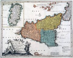 SIZILIEN. - Karte. - Insulae sive Regni Siciliae ante omnes Mediterranei maris Insulas clarissimae Tabula diligentissime novissimeque.
Altkol. Kupferstich von Mich. Kauffer bei Chr. Weigel, 1718, 33 x 42 cm.
Aus: Johann David Köhlers "Bequemer Schul= und Reisen=Atlas", 1718. - Dekorative Gesamtkarte mit Nebenkarte von Sardinien und großer Kartusche links unten. (Artikelnr. 18649BG)
Erfahren Sie mehr380,00 € Inkl. MwSt. -
RUSSLAND. - Karte. - Europaeisches Russland auch Schweden u. Norwegen. Dabei Uebersicht Des Oesterreichischen u. Preussischen Staats.
Grenzkol. Kupferstich aus Stieler bei Perthes, Gotha, 1866, 32,5 x 39,5 cm.
Espenhorst, PP 2.1.1.1.4. - Aus: A. Stieler's "Hand-Atlas" (4. Ausgabe, Auflage 1866). - Mittelbug verso verstärkt, der Rand unten alt beklebt. (Artikelnr. 34907EG)
Erfahren Sie mehr80,00 € Inkl. MwSt. -
SPANIEN und PORTUGAL. - Karte. - Gesamtkarte der Iberischen Halbinsel, mit Balearen und Ibiza sowie vier Umgebungskarten.
Grenzkol. Kupferstich nach Weiland, Weimar im Geograph. Institut, dat. 1857, 49 x 60 cm.
Espenhorst, PP 1.1.5. - Die Umgebungskarten zeigen: Gibraltar, Lissabon, Cadiz und Madrid. Im Süden die Nordwestküste Afrikas zwischen El Araiche un... (Artikelnr. 33154EG)
Erfahren Sie mehr158,00 € Inkl. MwSt. -
 SPANIEN und PORTUGAL. - Karte. - Spanien und Portugal. Gesamtkarte mit den Balearen (Ibiza, Mallorca und Menorca).
Kupferstich mit Farblithographie von Weiler nach Vogel aus Stieler bei Perthes, Gotha, 1891, 33 x 40 cm.
Espenhorst, PP 2.1.1.1.8. - Aus: A. Stieler's "Hand-Atlas" (8. Ausgabe, Auflage 1891). - Mit einer Nebenkarte von Lissabon. (Artikelnr. 19171BG)
Erfahren Sie mehr85,00 € Inkl. MwSt. -
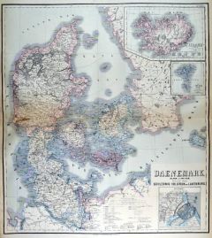 DÄNEMARK. - Karte. - Daenemark, Island u. die Far-Oer. Die preussischen Provinzen Schleswig, Holstein und Lauenburg.
Farblithographie, Weimar im Geograph. Institut, 1885, 61 x 55 cm.
Espenhorst, PP, 1.1.6. - Aus: Heinrich Kiepert's "Grosser Handatlas" (49. Ausgabe, Auflage 1885). - Mit drei Nebenkarten: Island, Far-Oer, Kopenhagen. - Im Randbereich des M... (Artikelnr. 35257EG)
Erfahren Sie mehr90,00 € Inkl. MwSt.