Suchergebnisse für: "europa karte"
-
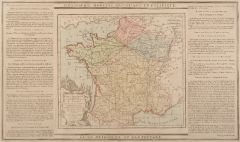
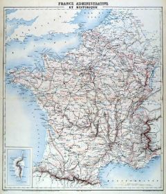 FRANKREICH. - Karte. - France Administrative et Historique. Mit Korsika. Einteilung in Départements, mit der alten und neuen Ostgrenze.
Farblithographie von Erhard nach E. Bureau bei Lemercier bzw. Furne, Paris, um 1871, 45,5 x 40 cm.
Aus "Atlas de Géographie Militaire". (Artikelnr. 34777EG)
Erfahren Sie mehr85,00 € Inkl. MwSt. -
GROSSBRITANNIEN. - Karte. - General Carte von Gross Britannien nach den neuesten Hilfsmitteln bearbeitet. Gesamtkarte mit Irland, oben Inschrift.
Grenzkol. Kupferstich bei T. Mollo, Wien um 1825, 45 x 32,5 cm.
Mit einer Nebenkarte der "Inseln Schetand". - Im Randbereich z.T. leicht fleckig. (Artikelnr. 606FG)
Erfahren Sie mehr120,00 € Inkl. MwSt. -
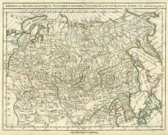 RUSSLAND. - Asiatischer Teil. - Karte. - Siberie ou Russie Asiatique, Tartarie Chinoise, Pays des Fluts et Isles du Japon.
Grenzkol. Kupferstich von R. de Vaugondy, um 1780, 24 x 31 cm.
Zeigt das Gebiet vom Polen bis zum Pazifik mit Japan, im Südosten Korea. (Artikelnr. 32540EG)
Erfahren Sie mehr128,00 € Inkl. MwSt. -
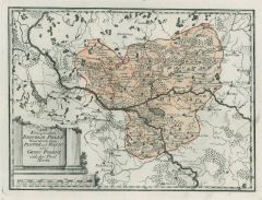 POLEN. - Karte. - Der königlichen Republik Polen Woiwodschaften Plotzk und Masau oder Groß Polens östlicher Teil Nro. 41.
Grenzkol. Kupferstich von Reilly, um 1790, 21 x 28 cm.
Mit der Weichsel im Mittelgrund von Thorn bis Kozyenice und die Bug bis Grano. (Artikelnr. 17504AG)
Erfahren Sie mehr110,00 € Inkl. MwSt. -
GROSSBRITANNIEN. - Karte. - Charte der vereinigten Königreiche Grosbritanien und Irland. Gesamtkarte mit Irland.
Grenzkol. Kupferstich nach Weidner, Weimar im Geograph. Institut, dat. 1817, 59,5 x 48 cm.
Espenhorst PP, 1.1.2; aus "Allgemeiner Handatlas" (Bundausgabe). - "Nach den neuesten Berichtigungen und astronomischen Ortsbestimmungen entworfen a... (Artikelnr. 32435EG)
Erfahren Sie mehr120,00 € Inkl. MwSt. -
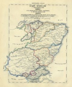
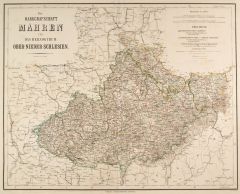 MÄHREN. - Karte. - Die Markgrafschaft Mähren und das Herzogthum Ober u. Nieder-Schlesien.
Grenzkol. Kupferstich von Geyer und Hensgen nach Gräf, Weimar im Geograph. Institut, 1872, 44,5 x 55,5 cm.
Espenhorst, PP 1.1.6. - Aus: Heinrich Kiepert's "Grosser Hand-Atlas" (43. Ausgabe, Auflage 1872). - Gewann 1871 die einzige Goldmed... (Artikelnr. 35507EG)
Erfahren Sie mehr110,00 € Inkl. MwSt. -
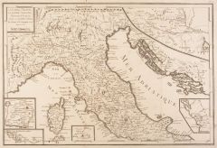 ITALIEN. - Norditalien. - Karte. - La Corse, l'Illyrie, la Gaule Cisalpine, Partie de l'Italie, et de la Grece.
Kupferstich bei J.-R. Joly, 1801, 31,5 x 46,5 cm.
Zeigt Norditalien von den Alpen bis Rom, mit fünf kleine Nebenkarten u. a. von Rom und Dalmatien. - Faltspuren. (Artikelnr. 14779BG)
Erfahren Sie mehr133,00 € Inkl. MwSt. -
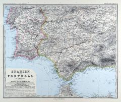
SPANIEN und PORTUGAL. - Karte. - Spanien und Portugal. Gesamtkarte der Iberischen Halbinsel, mit Balearen und Afrikanischer Gegenküste.
Farblithographie nach Wolf aus Spamer, 1902, 31,5 x 41,5 cm.
Espenhorst, PP 23.2. - Aus: O. Spamer's "Grosser Hand-Atlas" (2. Ausgabe, Auflage 1902). - Verso Typographie, mit 7 Gebietskarten. (Artikelnr. 35096EG)
Erfahren Sie mehr95,00 € Inkl. MwSt. -
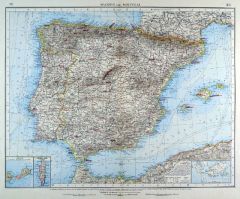
SPANIEN und PORTUGAL. - Karte. - Spanien und Portugal. Gesamtkarte der Iberischen Halbinsel, mit Balearen und Nebenkarte Menorca.
Grenzkol. Kupferstich von Schmidt nach Heck aus Stein bei Hinrichs, 1857, 40 x 48 cm.
Espenhorst, PP 31.1.1.2. - Aus: C.G.D. Stein "Neuer Atlas der ganzen Erde" (29. Ausgabe, Auflage 1857). (Artikelnr. 34919EG)
Erfahren Sie mehr100,00 € Inkl. MwSt. -
 JUNGBUNZLAU (Mladá Boleslav). - Karte. - Zeigt das Gebiet zwischen Wartenberg bis Brodecz im Westen, im Osten Riesengebirge bis Horzitze.
Kupferstich, Weimar im Geograph. Institut, 1807, 32 x 41 cm.
Sehr detaillierte Sektionskarte (99) mit auch kleinsten Orten, Gewässern etc. (Artikelnr. 9896AG)
Erfahren Sie mehr85,00 € Inkl. MwSt. -
GROSSBRITANNIEN. - Karte. - Die Britischen Inseln oder die Vereinigten Königreiche Grossbritannien und Ireland. Gesamtkarte.
Grenzkol. Kupferstich von Kraatz nach Kiepert, Weimar im Geograph. Institut, 1872, 61 x 51 cm.
Espenhorst, PP 1.1.6. - Aus: Heinrich Kiepert's "Grosser Hand-Atlas" (43. Ausgabe, Auflage 1872). - Gewann 1871 die einzige Goldmedaille auf dem... (Artikelnr. 35464EG)
Erfahren Sie mehr114,00 € Inkl. MwSt. -
PIEMONT. - Karte. - Ducatus Sabaudiae Principatus Pedemontii Ducatus Montisferratensis cum contiguis ad Ortu & Occasu.
Altkol. Kupferstich von Mich. Kauffer bei Chr. Weigel, 1718, 32 x 37 cm.
Aus: Johann David Köhlers "Bequemer Schul= und Reisen=Atlas", 1718. - Zeigt die Region Piemont mit Teilen von Mailand und Ligurien, bzw. das Gebiet zwischen Saint Ma... (Artikelnr. 18644BG)
Erfahren Sie mehr250,00 € Inkl. MwSt. -
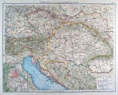 ÖSTERREICH und UNGARN. - Karte. - Übersichtskarte von Österreich-Ungarn. Mit Nebenkarte "Wien und Umgebung".
Farblithographie von Anschütz nach Umbreit aus Andree bei Velhagen & Klasing, 1899, 37 x 46,5 cm.
Espenhorst, PP 5.1.4. - Aus: Richard Andree's "Allgemeiner Handatlas" (4. Ausgabe, Auflage 1899). - "Mit dieser Ausgabe wurde der ANDREE zum... (Artikelnr. 34999EG)
Erfahren Sie mehr110,00 € Inkl. MwSt. -
FRANKREICH. - Karte. - Frankreich und Umgebungen von Paris. Gesamtkarte mit Korsika, dazu Umgebungsplan von Paris.
Grenzkol. Kupferstich von C. Stier nach F.v. Stülpnagel bei Perthes, Gotha, dat. 1838, 30,5 x 35,5 cm.
Espenhorst, PP 2.1.1.1. - Aus: A. Stieler's "Hand-Atlas" (First Edition, "the one least often found" (=die seltenste Ausgabe)). - Mit g... (Artikelnr. 33196EG)
Erfahren Sie mehr114,00 € Inkl. MwSt. -
FRANKREICH. - Nordfrankreich. - Karte. - Campagne de France 1814, mit der Umgebung von Paris als Nebenkarte.
Kupferstich von Jacobs nach F. de Lemud bei Lemercier bzw. Furne, Paris, 1858, 22 x 32,5 cm.
Aus: Théophile Lavallée's "Atlas de Géographie Militaire". - Zeigt das Gebiet von Paris bis zur Mosel, im Norden Mezieres und Luxembourg, im S?... (Artikelnr. 34857EG)
Erfahren Sie mehr64,00 € Inkl. MwSt. -
ITALIEN. - Norditalien. - Karte. - Lombardiae Inferioris Tabula in qua Ditio Veneta, Parmensis, Mutinensis et Mantuana.
Altkol. Kupferstich von Mich. Kauffer bei Chr. Weigel, 1718, 31 x 39 cm.
Aus: Johann David Köhlers "Bequemer Schul= und Reisen=Atlas", 1718. - Zeigt den nord-östlichen Teil von Italien (Venetien) mit dem Gebiet zwischen Brixen, Pula in K... (Artikelnr. 18646BG)
Erfahren Sie mehr280,00 € Inkl. MwSt. -
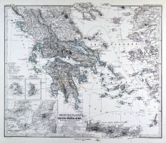 GRIECHENLAND. - Karte. - Griechenland und der Griechisch-Türkische Archipel. Gesamtkarte, mit Ägäis und drei Nebenkarten.
Grenzkol. Kupferstich von Jungmann nach Habenicht und Petermann aus Stieler bei Perthes, Gotha, 1875, 33,5 x 40 cm.
Espenhorst, PP 2.1.1.1.6. - Aus: A. Stieler's "Hand-Atlas" (6. Ausgabe, Auflage 1875). - Zeigt im Norden Korfu und Saloniki... (Artikelnr. 35388EG)
Erfahren Sie mehr90,00 € Inkl. MwSt. -
 SPANIEN und PORTUGAL. - Karte. - Spanien und Portugal in 4 Blättern. Gesamtkarte in 4 Blättern.
4 Kupferstiche mit Farblithographie von Weiler nach Vogel aus Stieler bei Perthes, Gotha, 1891, je 33,5 x 41 cm.
Espenhorst, PP 2.1.1.1.8. - Aus: A. Stieler's "Hand-Atlas" (8. Ausgabe, Auflage 1891). - Schöne Gesamtkarte von Spanien und P... (Artikelnr. 19172BG)
Erfahren Sie mehr260,00 € Inkl. MwSt. -
 SPANIEN und PORTUGAL. - Karte. - Spanien und Portugal, mit Balearen. Mit drei Nebenkarten.
Farblithographie nach Scrobel aus Andree bei Velhagen & Klasing, 1899, 36,5 x 47,50 cm.
Espenhorst, PP 5.1.4. - Aus: Richard Andree's "Allgemeiner Handatlas" (4. Ausgabe, Auflage 1899). - "Mit dieser Ausgabe wurde der ANDREE zum führenden... (Artikelnr. 35020EG)
Erfahren Sie mehr120,00 € Inkl. MwSt. -
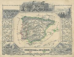 SPANIEN und PORTUGAL. - Karte. - Portugal u. Spanien. Gesamtkarte (10,5 x 14 cm), umgeben von mehreren Figuren und historischen Szenen.
Grenzkol. Kupferstich bei J. Berlin, 1853, 16 x 20,5 cm.
Espenhorst, PP 63,5. - Im Rand gering unfrisch. (Artikelnr. 26797CG)
Erfahren Sie mehr80,00 € Inkl. MwSt. -
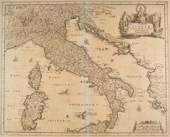 ITALIEN. - Italien. - Karte. - Tabula Italiae. Italien mit Korsika, Sardinien und der nördlichen Hälfte von Sizilien.
Kupferstich von Frederik de Wit, um 1680, 42 x 53 cm.
Zeigt zusätzlich die dalmatinische und die albanische Küste bis Korfu. Oben rechts Titelkartusche. - Mit zwei kleinen hinterlegten Randeinrissen und verstärktem Bug. Im Ganzen gleich... (Artikelnr. 41438EG)
Erfahren Sie mehr380,00 € Inkl. MwSt. -
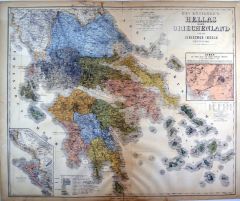 GRIECHENLAND. - Karte. - Das Königreich Hellas oder Griechenland und die Ionischen Inseln (Ephtánisos). Mit zwei Nebenkarten.
Farblithographie, Weimar im Geograph. Institut, 1885, 55,5 x 66 cm.
Espenhorst, PP 1.1.6. - Aus: Heinrich Kiepert's "Grosser Handatlas" (49. Ausgabe, Auflage 1885). - Die Nebenkarten zeigen Korfu und die Umgebung von Athen. - Im Randbereic... (Artikelnr. 35274EG)
Erfahren Sie mehr110,00 € Inkl. MwSt. -
SPANIEN und PORTUGAL. - Karte. - Spanien und Portugal. Gesamtkarte mit den Balearen (Ibiza, Mallorca und Menorca).
Farblithographie aus J.M. Ziegler bei J. Wurster, Winterthur, 1864, 41 x 55 cm.
Espenhorst, PP 65.1. - Aus: Jakob Melchior Ziegler's "Geographischer Atlas über alle Theile der Erde" (2. Auflage von 1864). - In den Rändern leicht fleckig. (Artikelnr. 19000BG)
Erfahren Sie mehr180,00 € Inkl. MwSt. -
RUMÄNIEN. - Karte. - Untere Donauländer und Türkei. Östliche Hälfte, mit Rumänien und Rumelien. Mit einer Nebenkarte.
Farblithographie nach Scrobel aus Andree bei Velhagen & Klasing, 1900, 50 x 37,5 cm.
Espenhorst, PP 5.1.4. - Aus: Richard Andree's "Allgemeiner Handatlas" (4. Ausgabe, Auflage 1900). - Mit Aussprachehinweisen, u.a für das Rumänische. Di... (Artikelnr. 743FG)
Erfahren Sie mehr120,00 € Inkl. MwSt. -
 POLEN. - Karte. - Der königlichen Republik Polen Woiwodschaften Sieradz, Lentschitz und Rawa oder Groß Polens südlicher Teil Nro. 40.
Grenzkol. Kupferstich von Reilly, um 1790, 21 x 28 cm.
Im Südosten die Weichsel mit Warschau, im Westen die Wartha zwischen Posen und Brzesnice. (Artikelnr. 17506AG)
Erfahren Sie mehr120,00 € Inkl. MwSt. -
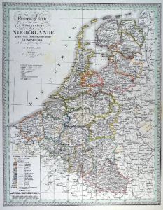 NIEDERLANDE. - Benelux. - Karte. - General-Charte von dem Königreiche der Niederlande nebst dem Grossherzogthume Luxemburg. Gesamtkarte der Beneluxstaaten.
Grenzkol. Kupferstich nach Weiland, Weimar im Geograph. Institut, dat. 1826, 57,5 x 44 cm.
Espenhorst, PP 1.1.2. - Mit Farberklärungen für die 17 Provinzen und Luxemburg. (Artikelnr. 33073EG)
Erfahren Sie mehr120,00 € Inkl. MwSt. -
SPANIEN und PORTUGAL. - Karte. - Carte Physique et Militaire de la Péninsule. Mit Nebenkarte der Umgebung von Lissabon.
Farblithographie von Erhard nach E. Bureau bei Lemercier bzw. Furne, Paris, um 1871, 38,5 x 48 cm.
Aus "Atlas de Géographie Militaire". - Mit Gebirgen, Flußläufen, Hauptstraßen und Eisenbahnlinien. (Artikelnr. 34794EG)
Erfahren Sie mehr90,00 € Inkl. MwSt. -
 NORWEGEN. - Karte. - Regni Norwegiae, Accvrata Tabvla in qua Praefecturae quinque Generales Aggerhvsiensis, Bergensis, Nidrosiensis, Wardhvsiensis et Bahvsiensis.
Altkol. Kupferstich von J.B. Homann, um 1720, 58 x 50 cm.
Gesamtkarte mit Nebenkarte von Nordnorwegen und der Finnmark links oben. Dekorative Titelkartusche mit Wappen und allegorischen Figuren und Druckprivileg. (Artikelnr. 1128GG)
Erfahren Sie mehr380,00 € Inkl. MwSt. -
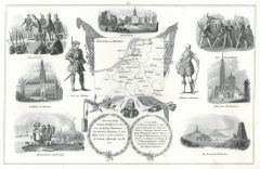 NIEDERLANDE. - Benelux. - Karte. - Umrißkarte von Holland und Belgien (7 x 8,5 cm), umgeben von 10 Ansichten, Szenen und Porträts.
Lithographie bei Schach, 1844, 20 x 30,5 cm.
Die Ansichten zeigen Amsterdam, Waterloo, Brüssel, Antwerpen sowie Trachtengruppen. (Artikelnr. 7790AG)
Erfahren Sie mehr68,00 € Inkl. MwSt. -
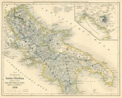 ITALIEN. - Süditalien. - Karte. - Das Königreich beider Sicilien, Nördliche Haelfte: Abruzzo, Terra Lavoro, Apulien, und Calabrien 1849 mit Nebenkarten Umgebung von Neapel.
Grenzkol. Stahlstich aus Meyer's Zeitungsatlas, 1849, 21 x 26 cm. (Artikelnr. 358AG)
Erfahren Sie mehr45,00 € Inkl. MwSt. -
FRANKREICH. - Karte. - Frankreich und die Schweiz. Gesamtkarte mit Departements. Mit Korsika und zwei Nebenkarten.
Grenzkol. Kupferstich von Alt nach Berghaus aus Stieler bei Perthes, Gotha, 1866, 33,5 x 35,5 cm.
Espenhorst, PP 2.1.1.1.4. - Aus: A. Stieler's "Hand-Atlas" (4. Ausgabe, Auflage 1866). - Die Nebenkarten zeigen die Umgebungen von Paris und ... (Artikelnr. 34898EG)
Erfahren Sie mehr60,00 € Inkl. MwSt. -
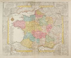
FRANKREICH. - Karte. - Royaume de France Divisé en 86 Départements. Frankreich und seine Departements, nach 1790.
Grenzkol. Kupferstich aus Delamarche, dat. 1833, 27,5 x 36 cm.
Aus: Felix Delamarche's "Atlas de la Géographie ancienne, du moyen-age et moderne". - Der Ingenieur und Mechaniker für Erd- und Himmelsgloben übernahm 1811 das Atlantengesch... (Artikelnr. 34829EG)
Erfahren Sie mehr75,00 € Inkl. MwSt. -
ITALIEN. - Karte. - Italiae Antiquae Mappa Nova. Das antike Italien, mit den Siedlungsgebieten der italienischen Volksstämme.
Grenzkol. Kupferstich aus Delamarche, dat. 1833, 30 x 35 cm.
Aus: Felix Delamarche's "Atlas de la Géographie ancienne, du moyen-age et moderne". - Der Ingenieur und Mechaniker für Erd- und Himmelsgloben übernahm 1811 das Atlantengeschä... (Artikelnr. 34846EG)
Erfahren Sie mehr80,00 € Inkl. MwSt. -
GRIECHENLAND. - Karte. - Carte Physique & Politique de la Turquie D'Europe, des 3 Principautés, de la Grèce.
Grenzkol. Kupferstich von Marlier aus Dussieux bei Lecoffre, dat. 1847, 38,5 x 27,5 cm.
Aus: Louis Dussieux's "Atlas Général de Géographie". - Zeigt das Gebiet von Südungarn bzw. der Donaumündung bis Kreta, im Osten der Bosporus. - In... (Artikelnr. 34815EG)
Erfahren Sie mehr60,00 € Inkl. MwSt. -
JUGOSLAWIEN. - Karte. - Untere Donauländer und Türkei. Westliche Hälfte, mit den Ländern zwischen Donau und Adria.
Farblithographie nach Scrobel aus Andree bei Velhagen & Klasing, 1900, 37,5 x 50,5 cm.
Espenhorst, PP 5.1.4. - Aus: Richard Andree's "Allgemeiner Handatlas" (4. Ausgabe, Auflage 1900). - Zeigt im Südosten das nördliche Griechenland mit A... (Artikelnr. 742FG)
Erfahren Sie mehr120,00 € Inkl. MwSt. -
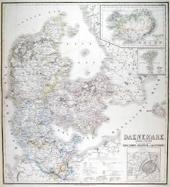
DÄNEMARK. - Karte. - Dänemark mit Schleswig, Holstein und Lauenburg, nebst den Dänischen Colonien. Mit fünf Nebenkarten.
Grenzkol. Kupferstich von Hanemann nach Petermann und Friederichsen aus Stieler bei Perthes, Gotha, 1866, 34,5 x 40 cm.
Espenhorst, PP 2.1.1.1.4. - Aus: A. Stieler's "Hand-Atlas" (4. Ausgabe, Auflage 1866). - Die Nebenkarten zeigen Kopenha... (Artikelnr. 34900EG)
Erfahren Sie mehr75,00 € Inkl. MwSt. -
 DÄNEMARK. - Karte. - Daenemark, Island u. die Far-Oer. Die preussischen Provinzen Schleswig, Holstein und Lauenburg.
Grenzkol. Kupferstich von Haubold nach Gräf, Weimar im Geograph. Institut, 1872, 60 x 54,5 cm.
Espenhorst, PP 1.1.6. - Aus: Heinrich Kiepert's "Grosser Hand-Atlas" (43. Ausgabe, Auflage 1872). - Gewann 1871 die einzige Goldmedaille auf de... (Artikelnr. 35467EG)
Erfahren Sie mehr120,00 € Inkl. MwSt. -
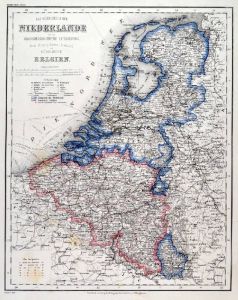 NIEDERLANDE. - Benelux. - Karte. - Das Königreich der Niederlande mit dem Grossherzogthume Luxemburg, dem Herzogthume Limburg und Königreich Belgien. Gesamtkarte.
Grenzkol. Stahlstich aus Meyer bei BI, um 1865, 37 x 29,5 cm.
Espenhorst, PP 3.4 (Meyer-Ravenstein 1862-1884). - Aus: Joseph Meyer's "Hand-Atlas", redigiert von Ludwig Ravenstein (1838-1915). (Artikelnr. 19271BG)
Erfahren Sie mehr90,00 € Inkl. MwSt. -
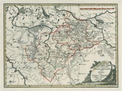
 ZLIN/Mähren. - Karte. - Südöstliche Umgebung von Zlin bis zur Grenze mit den Orten Klobuk, Brumow, Wisowitz, Ungarisch-Brod.
Kupferstich, Weimar im Geograph. Institut, 1807, 30,5 x 40,5 cm (davon nur ca. 30 x 23 cm ausgefüllt).
Sehr detaillierte Sektionskarte (140), auch mit kleinsten Orten, Gewässern und Bergen. (Artikelnr. 15378AG)
Erfahren Sie mehr40,00 € Inkl. MwSt. -
ÖSTERREICH. - Karte. - Die K. Österreichischen Kronländer Steiermark, Kärnten, Krain und das Küstenland (Görz, Gradisca, Istrien und Triest). Gebietskarte.
Grenzkol. Kupferstich nach Weiland, Weimar im Geograph. Institut, dat. 1857, 58,5 x 46,5 cm.
Espenhorst, PP 1.1.5. - Mit Farbangaben. "Nach der neuesten politischen Eintheilung berichtigt". (Artikelnr. 33133EG)
Erfahren Sie mehr110,00 € Inkl. MwSt. -
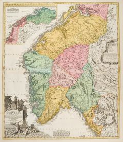
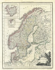 SKANDINAVIEN. - Karte. - Danemark, Suede et Norwege. Die Königreiche Schweden, Norwegen und Dänemark. Mit Nebenkarten Island und Îles Faeroe.
Grenzkol. Kupferstich von J.P. Tardieu nach Giraldon, 1812, 28,5 x 22 cm.
Gesamtkarte mit Maßstab und floraler Titelkartusche. Das Grenzkolorit zeigt für Schweden die Einteilung der Kreise. (Artikelnr. 32891EG)
Erfahren Sie mehr90,00 € Inkl. MwSt. -
 FRANKREICH. - Karte. - Carte Itineraire et Générale des 18 Feuilles de l'indicateur de France. Gesamtkarte, eingeteilt nach Reiserouten.
Altkol. Kupferstich von Brion de la Tour, 1790, 23 x 26 cm, mit Legende 28 x 48 cm.
Beidseitig montierte Legende, die geographische, statistische und historische Besonderheiten beschreibt. - Kartusche etwas schwach. (Artikelnr. 7670AG)
Erfahren Sie mehr70,00 € Inkl. MwSt. -
FRANKREICH. - Karte. - Frankreich in 4 Blättern. Gesamtkarte in vier Teilen, mit Korsika und Nebenkarte (Umgebung von Paris).
4 grenzkol. Kupferstiche von Weiler nach Vogel aus Stieler bei Perthes, Gotha, 1875, je 33 x 41 cm.
Espenhorst, PP 2.1.1.1.6. - Aus: A. Stieler's "Hand-Atlas" (6. Ausgabe, Auflage 1875). (Artikelnr. 34880EG)
Erfahren Sie mehr200,00 € Inkl. MwSt. -
NIEDERLANDE. - Benelux. - Karte. - Koenigreiche der Niederlande und Belgien. Gesamtkarte mit Luxemburg. Mit Grundrißplänen von Antwerpen und Brüssel.
Grenzkol. Kupferstich nach Koehler aus Stein bei Hinrichs, 1857, 48 x 38,5 cm.
Espenhorst, PP 31.1.1.2. - Aus: C.G.D. Stein "Neuer Atlas der ganzen Erde" (29. Ausgabe, Auflage 1857). (Artikelnr. 34923EG)
Erfahren Sie mehr80,00 € Inkl. MwSt. -
 BÖHMEN. - Karte. - Des Königreichs Böheim Kreise Saatz, Rakonitz und Ellenbogen mit dem Distrikte Egger und der Hauptstadt Prag Nro. 96.
Grenzkol. Kupferstich von Reilly, um 1790, 20 x 33 cm.
Zeigt das Gebiet westlich der Elbe bis Eger. (Artikelnr. 24377CG)
Erfahren Sie mehr130,00 € Inkl. MwSt. -
GRIECHENLAND. - Karte. - Griechenland und der Griechisch-Türkische Archipel. Gesamtkarte, mit Ägäis und drei Nebenkarten.
Grenzkol. Kupferstich von Jungmann nach Habenicht und Petermann aus Stieler bei Perthes, Gotha, 1867, 35,5 x 40 cm.
Espenhorst, PP 2.1.1.1.4. - Aus: A. Stieler's "Hand-Atlas" (4. Ausgabe, Auflage 1867). - Zeigt Griechenland mit der damalig... (Artikelnr. 34892EG)
Erfahren Sie mehr90,00 € Inkl. MwSt. -
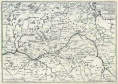
VALENCIENNES. - Karte. - Particular Carta Von denen Mouvements derer Hohen Alliirten Armée ... Und der Frantzösischen Armée 1712. Umgebungskarte mit Einzeichnung der Truppenstellungen.
Kupferstich von Merian aus "Theatrum Europaeum", 1723, 36 x 45 cm (Fauser 14576). (Artikelnr. 12363BG)
Erfahren Sie mehr95,00 € Inkl. MwSt. -
 FRANKREICH. - Karte. - Le Royaume de France et les Conquetes de Louis le Grand.
Altkol. Kupferstich von Steinberger bei Tobias Conrad Lotter, um 1740, 46,5 x 57 cm.
Gesamtkarte umgeben von einer Bordüre mit 19 Befestigungsplänen mit Erklärungen der Städte die durch Ludwig IV. erobert wurden. U. a. dargestellt sind... (Artikelnr. 14870BG)
Erfahren Sie mehr400,00 € Inkl. MwSt.