Suchergebnisse für: "europa karte"
-
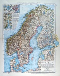 SKANDINAVIEN. - Karte. - Übersichtskarte von Schweden und Norwegen, Finnland und Dänemark. Mit zwei Nebenkarten.
Farblithographie von Kehr nach Umbreit aus Andree bei Velhagen & Klasing, 1899, 49,5 x 37,5 cm.
Espenhorst, PP 5.1.4. - Aus: Richard Andree's "Allgemeiner Handatlas" (4. Ausgabe, Auflage 1899). - "Mit dieser Ausgabe wurde der ANDREE zum f?... (Artikelnr. 35017EG)
Erfahren Sie mehr110,00 € Inkl. MwSt. -
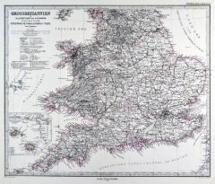
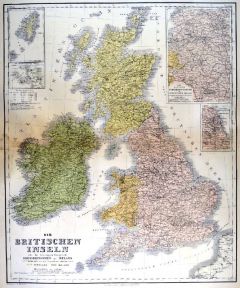 GROSSBRITANNIEN. - Karte. - Die Britischen Inseln oder die Vereinigten Königreiche Grossbritannien und Ireland. Mit vier Nebenkarten.
Kupferstich mit Farblithographie nach Kiepert, Weimar im Geograph. Institut, 1886, 62 x 51 cm.
Espenhorst, PP 1.1.6. - Aus: Heinrich Kiepert's "Grosser Hand-Atlas" (49. Ausgabe, Auflage 1886). - Zeigt im Südosten die nordfranzösische Kü... (Artikelnr. 35165EG)
Erfahren Sie mehr90,00 € Inkl. MwSt. -
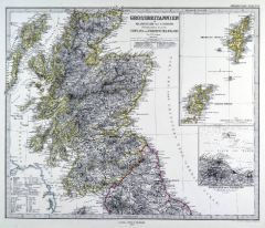 SCHOTTLAND. - Karte. - Grossbritannien. Nördliches Blatt. Schottland und der Nördlichste Teil Englands. Mit Anschlußkarte und Nebenkarte.
Grenzkol. Kupferstich von Poppey nach Petermann aus Stieler bei Perthes, Gotha, 1875, 33,5 x 40 cm.
Espenhorst, PP 2.1.1.1.6. - Aus: A. Stieler's "Hand-Atlas" (6. Ausgabe, Auflage 1875). - Im Süden bis zur Linie Kirkby Kendall - Scarborou... (Artikelnr. 35378EG)
Erfahren Sie mehr75,00 € Inkl. MwSt. -
BALKAN. - Karte. - Die Europaeische Türkei von der Gränze Griechenlands bis zu den Mündungen der Donau.
Grenzkol. Kupferstich von Thiel nach Stülpnagel aus Stieler bei Perthes, Gotha, dat. 1851, 32 x 38 cm.
Espenhorst, PP 2.1.1.1.2. - Aus: A. Stieler's "Hand-Atlas" ("Second Edition"). - Zeigt das Gebiet von Bosnien bis zum Schwarzen Meer bz... (Artikelnr. 33235EG)
Erfahren Sie mehr85,00 € Inkl. MwSt. -
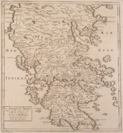
GRIECHENLAND. - Karte. - Griechenland und die Ionischen Inseln mit Beachtung der Klassischen Zeit. Mit zwei Plänen.
Grenzkol. Kupferstich nach Stülpnagel aus Stieler bei Perthes, Gotha, dat. 1850, 31 x 41 cm.
Espenhorst, PP 2.1.1.1.2. - Aus: A. Stieler's "Hand-Atlas" ("Second Edition"). - Mit Grenzkolorit für die "Neueste Eintheilung Griechenlands in ... (Artikelnr. 33236EG)
Erfahren Sie mehr100,00 € Inkl. MwSt. -
SPANIEN und PORTUGAL. - Karte. - Hispaniae Antiquae Tabula. Gesamtkarte der Iberischen Halbinsel zur Römerzeit, mit den Balearen.
Grenzkol. Kupferstich aus Delamarche, dat. 1833, 28 x 36,5 cm.
Aus: Felix Delamarche's "Atlas de la Géographie ancienne, du moyen-age et moderne". - Der Ingenieur und Mechaniker für Erd- und Himmelsgloben übernahm 1811 das Atlantengesch... (Artikelnr. 34844EG)
Erfahren Sie mehr70,00 € Inkl. MwSt. -
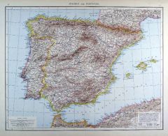 SPANIEN und PORTUGAL. - Karte. - Spanien und Portugal. Gesamtkarte der Iberischen Halbinsel, mit Balearen und Nordafrikanischer Küste.
Farblithographie aus Andree bei Velhagen & Klasing, 1881, 36,5 x 46,5 cm.
Espenhorst, PP 5.1.1. - Aus: Richard Andree's "Allgemeiner Handatlas" (1. Ausgabe, Auflage 1881). - Verso 3 weitere Darstellungen: "Meerenge von Gibraltar", "Belgien... (Artikelnr. 35334EG)
Erfahren Sie mehr95,00 € Inkl. MwSt. -
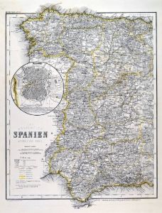 SPANIEN. - Karte. - Das Königreich Spanien. Westlicher Theil und "Östlicher Theil". Gesamtkarte von Spanien in zwei Blättern.
2 grenzkol. Stahlstiche nach Radefeld aus Meyer bei BI, um 1865, je 36 x 29 cm.
Espenhorst, PP 3.4 (Meyer-Ravenstein 1862-1884). - Aus: Joseph Meyer's "Hand-Atlas", redigiert von Ludwig Ravenstein (1838-1915). - Mit zwei Nebenkarten von Ma... (Artikelnr. 19294BG)
Erfahren Sie mehr180,00 € Inkl. MwSt. -
 FRANKREICH. - Karte. - Gebietskarte zwischen Ath und Lille im Norden, im Westen Aire und Doullens, im Süden Ham, im Osten Mons.
Kupferstich von D. A. Hauer bei W. Jaeger, um 1780, 47 x 62 cm.
Blatt 37 der "Carte Topographique d'Allemagne". (Artikelnr. 11869AG)
Erfahren Sie mehr95,00 € Inkl. MwSt. -
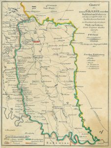 GALIZIEN. - Karte. - Charte ... des vermöge Traktats von 8/19 Merz 1810 von Oestreich an Russland abgetretenen Theils von Galizien. Gebietskarte.
Grenzkol. Kupferstich nach Streit, Weimar im Geograph. Institut, dat. 1810, 22 x 16 cm.
Zeigt das Gebiet zwischen Stripa, Podhorce und Dniester. (Artikelnr. 38722EG)
Erfahren Sie mehr68,00 € Inkl. MwSt. -
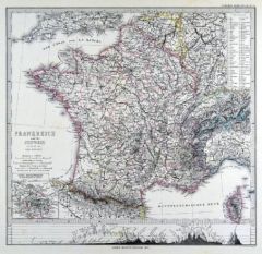
 FRANKREICH. - Karte. - Frankreich in 4 Blättern. Gesamtkarte in vier Teilen, mit Korsika und Nebenkarte (Umgebung von Paris).
4 grenzkol. Kupferstiche von Weiler nach Vogel aus Stieler bei Perthes, Gotha, 1875, je 33 x 41 cm.
Espenhorst, PP 2.1.1.1.6. - Aus: A. Stieler's "Hand-Atlas" (6. Ausgabe, Auflage 1875). - Im Rand teils leicht fleckig. (Artikelnr. 35372EG)
Erfahren Sie mehr200,00 € Inkl. MwSt. -
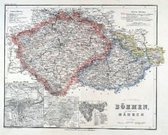 BÖHMEN und MÄHREN. - Karte. - Das Königreich Böhmen, die Markgrafschaft Mähren und das Herzogthum Ober- u. Nieder-Schlesien.
Grenzkol. Stahlstich nach Radefeld und Ravenstein aus Meyer bei BI, um 1865, 29,5 x 35,5 cm.
Espenhorst, PP 3.4 (Meyer-Ravenstein 1862-1884). - Aus: Joseph Meyer's "Hand-Atlas", redigiert von Ludwig Ravenstein (1838-1915). - Mit 3 Nebenkar... (Artikelnr. 19275BG)
Erfahren Sie mehr110,00 € Inkl. MwSt. -
 FRANKREICH. - Loire. - Karte. - Loirelauf von der Mündung bei Nantes bis Roanne, im Zentrum Orléans.
Altkol. Kupferstich von G. Valck, um 1710, 48,5 x 60 cm.
Flächenkolorierte Gebietskarte um das Orléanais. Zeigt im Nordwesten die Atlantikküste mit St. Malo und Avranches, im Westen das Gebiet von der Normandie über Anjou und Poitou bi... (Artikelnr. 32237EG)
Erfahren Sie mehr300,00 € Inkl. MwSt. -
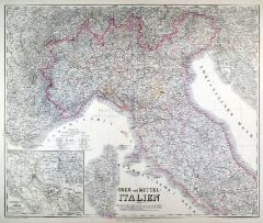 ITALIEN. - Nord- und Mittelitalien. - Karte. - Ober und Mittel-Italien. Gebietskarte, mit Umgebungskarte von Rom.
Grenzkol. Kupferstich von Mädel und Weiler nach Kiepert und Gräf, Weimar im Geograph. Institut, 1872, 51,5 x 62 cm.
Espenhorst, PP 1.1.6. - Aus: Heinrich Kiepert's "Grosser Hand-Atlas" (43. Ausgabe, Auflage 1872). - Gewann 1871 die einzi... (Artikelnr. 35520EG)
Erfahren Sie mehr120,00 € Inkl. MwSt. -
ITALIEN. - Norditalien. - Karte. - Ober - Italien. (Lombardei & Venetien). Mit einer Nebenkarte und einem Plan von Venedig.
Altkol. Lithographie von E. Serth bei E. Hochdanz und C. Hoffmann, Stuttgart, 1875, 28 x 38 cm.
Espenhorst, PP 21.2.3; aus "Illustrirter Volks-Atlas", nach T. Brommes Handatlas hrg. v. C.G. Reuschle. - Die Nebenkarte zeigt das Gebiet zwisc... (Artikelnr. 32913EG)
Erfahren Sie mehr120,00 € Inkl. MwSt. -
BALKAN. - Karte. - Die Europaeische Türkei von der Gränze Griechenlands bis zu den Mündungen der Donau.
Grenzkol. Kupferstich von Thiel nach Stülpnagel aus Stieler bei Perthes, Gotha, dat. 1834, 32 x 38 cm.
Espenhorst, PP 2.1.1.1. - Aus: A. Stieler's "Hand-Atlas" (First Edition, "the one least often found" (=die seltenste Ausgabe)). - Zeigt... (Artikelnr. 33206EG)
Erfahren Sie mehr100,00 € Inkl. MwSt. -
 SLOWENIEN. - Karte. - Nieder- und Ober-Österreich, Steiermark, Kärnten, Krain und Küstenland, mit Salzburg, Triest und Fiume.
Farblithographie von Wagner nach Berg aus Andree bei Velhagen & Klasing, 1899, 49,5 x 37,5 cm.
Espenhorst, PP 5.1.4. - Aus: Richard Andree's "Allgemeiner Handatlas" (4. Ausgabe, Auflage 1899). - "Mit dieser Ausgabe wurde der ANDREE zum fü... (Artikelnr. 35002EG)
Erfahren Sie mehr100,00 € Inkl. MwSt. -
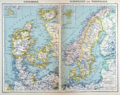 SKANDINAVIEN. - Karte. - Dänemark und "Schweden und Norwegen". Mit drei Nebenkarten. Insgesamt fünf Darstellungen auf einem Blatt.
Farblithographie nach Wolf aus Spamer, 1902, 31,5 x 41,5 cm.
Espenhorst, PP 23.2. - Aus: O. Spamer's "Grosser Hand-Atlas" (2. Ausgabe, Auflage 1902). - Zeigt im Osten auch Finnland und die Baltischen Staaten, im Süden Schleswig-Holstein u... (Artikelnr. 35089EG)
Erfahren Sie mehr100,00 € Inkl. MwSt. -
NIEDERLANDE. - Benelux. - Karte. - Das Königreich der Niederlande, das Königreich Belgien und das Grossherzogthum Luxemburg. Gesamtkarte der Beneluxstaaten.
Grenzkol. Kupferstich nach Weiland, Weimar im Geograph. Institut, dat. 1831, 37 x 28,5 cm.
Espenhost, PP 1.2.2. - Aus dem verkleinerten "Hand-Atlas ... für Bürgerschulen und Zeitungsleser" (sog. Bund-Ausgabe). - Seltener ("greater rarity... (Artikelnr. 33305EG)
Erfahren Sie mehr100,00 € Inkl. MwSt. -
 GROSSBRITANNIEN. - England. - Karte. - Grossbritannien. Südliches Blatt. England (ohne die Nördl. Grafschaften) u. Wales. Mit Nebenkarte "Die Canal-Inseln".
Grenzkol. Kupferstich von Poppey nach Petermann aus Stieler bei Perthes, Gotha, 1875, 33,5 x 40 cm.
Espenhorst, PP 2.1.1.1.6. - Aus: A. Stieler's "Hand-Atlas" (6. Ausgabe, Auflage 1875). - Im Norden bis zur Linie Broughton - Pickering. (Artikelnr. 35377EG)
Erfahren Sie mehr70,00 € Inkl. MwSt. -
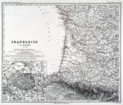
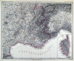 FRANKREICH. - Südfrankreich. - Karte. - Frankreich in 4 Blättern, Blatt 4. Südostfrankreich mit Provence und Côte d'Azur. Mit Nebenkarte "Corsica".
Grenzkol. Kupferstich von Weiler nach Vogel aus Stieler bei Perthes, Gotha, 1880, 33 x 41 cm.
Espenhorst, PP 2.1.1.1.6. - Aus: A. Stieler's "Hand-Atlas" (6. Ausgabe, Auflage 1880). - Im Rand oben leicht fleckig. (Artikelnr. 35287EG)
Erfahren Sie mehr65,00 € Inkl. MwSt. -
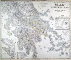 GRIECHENLAND. - Karte. - Das Königreich Hellas oder Griechenland und die Jonischen Inseln (Ephtánisos). Mit zwei Nebenkarten.
Grenzkol. Kupferstich von Herzberg nach Kiepert, Weimar im Geograph. Institut, 1872, 55 x 65,5 cm.
Espenhorst, PP 1.1.6. - Aus: Heinrich Kiepert's "Grosser Hand-Atlas" (43. Ausgabe, Auflage 1872). - Gewann 1871 die einzige Goldmedaille auf... (Artikelnr. 35469EG)
Erfahren Sie mehr130,00 € Inkl. MwSt. -
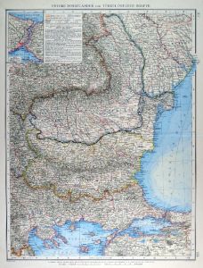 RUMÄNIEN. - Karte. - Untere Donauländer und Türkei. Östliche Hälfte, mit Rumänien und Rumelien. Mit einer Nebenkarte.
Farblithographie von Klug nach Jungk aus Andree bei Velhagen & Klasing, 1899, 50 x 37,5 cm.
Espenhorst, PP 5.1.4. - Aus: Richard Andree's "Allgemeiner Handatlas" (4. Ausgabe, Auflage 1899). - "Mit dieser Ausgabe wurde der ANDREE zum führe... (Artikelnr. 35028EG)
Erfahren Sie mehr120,00 € Inkl. MwSt. -
GROSSBRITANNIEN. - Karte. - Die Britischen Inseln oder die Vereinigten Königreiche Grossbritannien und Ireland. Gesamtkarte, mit vier Nebenkarten.
Grenzkol. Kupferstich von Kratz nach Kiepert und Gräf, Weimar im Geograph. Institut, dat. 1857, 62 x 50,5 cm.
Espenhorst, PP 1.1.5. -Aus: Heinrich Kiepert's "Hand-Atlas" (42. Ausgabe, 1856/69). - Die Nebenkarten zeigen: die Shetland- und ... (Artikelnr. 33155EG)
Erfahren Sie mehr130,00 € Inkl. MwSt. -
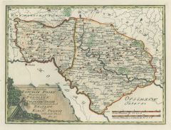
 POLEN. - Karte. - Der Königlichen Republik Polen Woiwodschaften Podlachien mit dem obern Theile der Woiwodschaft Lublin oder Klein Polens nördlicher Theil Nro. 43.
Grenzkol. Kupferstich von Reilly, um 1790, 21 x 28,5 cm.
Zeigt das Gebiet östlich von Warschau. Mit kolorierter Kartusche. (Artikelnr. 24395CG)
Erfahren Sie mehr120,00 € Inkl. MwSt. -
 FRANKREICH. - Karte. - Frankreich und die Schweiz. Gesamtkarte, im Osten die Schweiz. Mit Nebenkarte "Seine-Departement" und Höhenkarte.
Grenzkol. Kupferstich von Alt und Weiler nach Berghaus aus Stieler bei Perthes, Gotha, 1875, 33,5 x 35,5 cm.
Espenhorst, PP 2.1.1.1.6. - Aus: A. Stieler's "Hand-Atlas" (6. Ausgabe, Auflage 1875). - Die Höhenkarte im Unterrand zeigt die Ge... (Artikelnr. 35371EG)
Erfahren Sie mehr70,00 € Inkl. MwSt. -
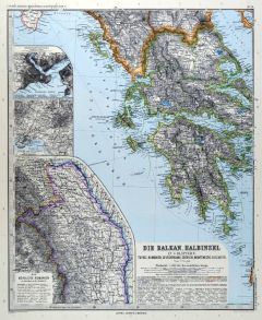 BALKAN. - Karte. - Die Balkan-Halbinsel in 4 Blättern. Türkei Rumänien, Griechenland, Serbien, Montenegro, Bulgarien. Gesamtkarte der Balkanhalbinsel.
4 Kupferstiche mit Farblithographie von Kern, Kühn und Weiler nach Vogel aus Stieler bei Perthes, Gotha, 1891, je 40,5 x 33 cm.
Espenhorst, PP 2.1.1.1.8. - Aus: A. Stieler's "Hand-Atlas" (8. Ausgabe, Auflage 1891). - Mit 5 Nebenkarten von... (Artikelnr. 19223BG)
Erfahren Sie mehr240,00 € Inkl. MwSt. -
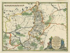
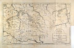 BÖHMEN. - Mähren und Schlesien. - Karte. - A Map of Part of the Seat of War in Germany etc.
Kupferstich, London, 1790, 35,5 x 58,5 cm.
Aus "Henry H.E. Lloyd, The history of the late war in Germany". Der in Wales geborene Generalmajor kämpfte im Siebenjährigen Krieg für Österreich. - Gesamtkarte. Im Süden die Donau zwischen R... (Artikelnr. 33827EG)
Erfahren Sie mehr98,00 € Inkl. MwSt. -
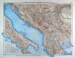 JUGOSLAWIEN. - Karte. - Untere Donauländer und Türkei. Westliche Hälfte, mit den Ländern zwischen Donau und Adria.
Farblithographie von Andrae nach Jungk aus Andree bei Velhagen & Klasing, 1899, 37,5 x 50,5 cm.
Espenhorst, PP 5.1.4. - Aus: Richard Andree's "Allgemeiner Handatlas" (4. Ausgabe, Auflage 1899). - "Mit dieser Ausgabe wurde der ANDREE zum f?... (Artikelnr. 35027EG)
Erfahren Sie mehr120,00 € Inkl. MwSt. -
RUSSLAND. - Asiatischer Teil. - Karte. - Carte Générale de la Russie Asiatique. Asiatisches Russland von der Wolga bis zur Behringstraße, oben links Inschrift und Meilenanzeiger.
Grenzkol. Kupferstich nach P.G. Chanlaire und E. Mentelle, Paris, um 1800, 28 x 49,5 cm. (Artikelnr. 32353EG)
Erfahren Sie mehr180,00 € Inkl. MwSt. -
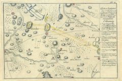 GABEL. - Karte. - Action bey Gabel den 2ten August 1778 zwischen den K.K. General Giulay und den K.Preus. General v. Pudjurski.
Altkol. Kupferstich, 1778, 20 x 30 cm.
Aus J.C. Adelungs "Schauplatz des Bayerischen Erbfolgekrieges". - Zeigt das Gebiet um Gabel bis Zwickau und Böhmisch-Aicha; mit Einzeichnung der Truppenstellungen. Faltspuren. (Artikelnr. 17861CG)
Erfahren Sie mehr75,00 € Inkl. MwSt. -
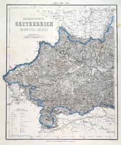 ÖSTERREICH. - Karte. - Das Erzherzogthum Oesterreich ob und unter der Enns. Westlicher Theil und "Oestlicher Theil". Gesamtkarte auf zwei Blättern.
2 grenzkol. Stahlstiche nach Radefeld aus Meyer bei BI, um 1865, je 36 x 29,5 cm.
Espenhorst, PP 3.4 (Meyer-Ravenstein 1862-1884). - Aus: Joseph Meyer's "Hand-Atlas", redigiert von Ludwig Ravenstein (1838-1915). - Minimal fleckig. (Artikelnr. 19278BG)
Erfahren Sie mehr200,00 € Inkl. MwSt. -
FRANKREICH. - Karte. - Royaume de France Divisé en ses 52 Provinces avant 1790. Frankreich und seine Provinzen, vor 1790.
Grenzkol. Kupferstich aus Delamarche, dat. 1833, 27,5 x 36 cm.
Aus: Felix Delamarche's "Atlas de la Géographie ancienne, du moyen-age et moderne". - Der Ingenieur und Mechaniker für Erd- und Himmelsgloben übernahm 1811 das Atlantengesch... (Artikelnr. 34828EG)
Erfahren Sie mehr70,00 € Inkl. MwSt. -
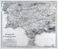 SPANIEN und PORTUGAL. - Karte. - Spanien und Portugal in 4 Blättern. Gesamtkarte, mit Balearen und Nebenkarte (Umgebung von Madrid).
4 grenzkol. Kupferstiche von Weiler nach Vogel aus Stieler bei Perthes, Gotha, 1875, je 33 x 41 cm.
Espenhorst, PP 2.1.1.1.6. - Aus: A. Stieler's "Hand-Atlas" (6. Ausgabe, Auflage 1875). - Blatt 4 (Südostspanien) beschädigt: hinterlegte ... (Artikelnr. 35374EG)
Erfahren Sie mehr200,00 € Inkl. MwSt. -
ITALIEN. - Karte. - Geographical and statistical Map of Italy. Gesamtkarte mit Sizilien, Sardinien und Korsika, umgeben von Texten zur Geschichte, Geographie und Kultur.
Altkol. Kupferstich von J. Walker aus Lavoisne, "Historical Atlas", dat. 1828, 42 x 52 cm.
Mit kleiner Nebenkarte rechts oben. Alte Unterstreichungen von Ortsnamen. (Artikelnr. 20173CG)
Erfahren Sie mehr170,00 € Inkl. MwSt. -
 ITALIEN. - Kirchenstaat. - Karte. - Gli Stati del Sommo Pontefice chiamati il Patrimonio di Sto. Pietro con insieme il Latio vecchio.
Altkol. Kupferstich bei Matthäus Seutter, gestochen von Tobias Conrad Lotter, um 1740, 49 x 58 cm.
Zeigt den Kirchenstaat von Narni und Aquila im Norden bis Terracina im Süden. - Mit großer figürlicher Kartusche links unten. (Artikelnr. 27588CG)
Erfahren Sie mehr450,00 € Inkl. MwSt. -
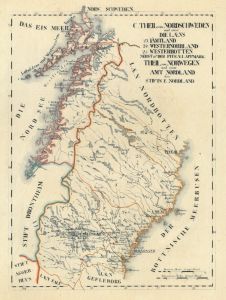
SKANDINAVIEN. - Karte. - Carte de la Scandinavie, mit den Königreichen Schweden, Norwegen und Dänemark. Mit Nebenkarten Island und Isles Faföe.
Grenzkol. Lithographie von P. Tardieu nach Lapie bei P.C. Lehuby, Paris, dat. 1838, 55 x 39,5 cm.
Aus "Atlas Universel", Nr. 29. - Gesamtkarte mit Maßstab . Das Grenzkolorit zeigt für Schweden die Einteilung der Kreise. - Insgesamt etwas... (Artikelnr. 31950EG)
Erfahren Sie mehr80,00 € Inkl. MwSt. -
 NIEDERLANDE. - Benelux. - Karte. - Les Pays-Bas, ou sont remarquées Les Aquisitions de la France jusque a la Treve de 1684.
Kupferstich von Nicolas de Fer, um 1712, 13 x 18 cm.
Zeigt das Gebiet zwischen Dokkum und Somme-Mündung, im Südosten Luxemburg und Koblenz. Mit schöner Kartusche, seitlich Wappenleisten mit 18 Wappen. - Alt aufgezogen. (Artikelnr. 36154EG)
Erfahren Sie mehr120,00 € Inkl. MwSt. -
FRANKREICH. - Karte. - Guienne et Gascogne, Basse Navarre et Béarn. Gebietskarte von Südwestfrankreich, mit Einteilung in elf Départements.
Grenzkol. Kupferstich von Dussy nach Delamarche und Robert de Vaugondy, Paris, dat. 1795, 24 x 26 cm.
Aus "Nouvel Atlas Portatif". - " L'An 3.me de la République Franc." Zeigt im Westen die Atlantikküste von der Gironde bis zu den Pyren?... (Artikelnr. 32365EG)
Erfahren Sie mehr94,00 € Inkl. MwSt.