Suchergebnisse für: "europa karte"
-
 VERSAILLES. - Kanal. - Karte. - Partie du Nouveau Canal. Fait pour la Conduitte de la Riviere d'Eure depuis Pontgouin jusques A Versailles. Verlauf des geplanten Kanals zwischen Pontgouin und dem Schloß Versailles. Drei Abschnitte auf dr
Kupferstiche bei Nicolas de Fer, 1695, je 20 x 26,5 cm.
Das von Ludwig XIV. in Planung gegebene Kanalprojekt (auch "Canal Louis XIV") sollte das Wasser der Eure über eine Entfernung von ca. 80 km zu den Wasserspielen im Park von Versaille... (Artikelnr. 41430EG)
Erfahren Sie mehr220,00 € Inkl. MwSt. -
VIERWALDSTÄTTERSEE. - Hardmeyer, J. - Der Vierwaldstättersee und seine Ufer.
Zürich, Orell-Füssli, (ca. 1880).
18 x 12 cm. 56 S. Mit 1 Karte (Umschlag-Rückseite) und 44 tls. ganzs. Holzstich-Illustrationen nach J. Weber. Mod. Lwd. mit mont. OUmschlag.
Europäische Wanderbilder Nr. 75 und 76. - Neu aufgebund... (Artikelnr. 1304CB)
Erfahren Sie mehr48,00 € Inkl. MwSt. -
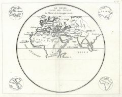 WELTKARTE. - Antike Welt. - Les Monde connu des Anciens.
Kupferstich bei J.-R. Joly, 1801, 23 x 29 cm.
Karte im Rund der antiken Welt mit Europa, Nordafrika und Asien. In den Ecken im Rund kleine Umrißkarten der vier Erdteile. (Artikelnr. 16793CG)
Erfahren Sie mehr110,00 € Inkl. MwSt. -
 BADEN-BADEN. - Baden-Baden und Umgebung.
Zürich, Orell-Füssli, 1879.
18 x 12 cm. 40 S. Mit 21 Holzstichen nach J. Weber und 1 Karte. Illustr. OBroschur.
Europäische Wanderbilder Nr. 9. - Mit hübschen Gesamt- und Teilansichten im Text und auf Tafeln. (Artikelnr. 1315CB)
Erfahren Sie mehr60,00 € Inkl. MwSt. -
 INTERLAKEN. - Gerber. - Interlaken.
Zürich, Orell-Füssli, ca. 1880.
18 x 12 cm. 48 S. Mit 20 Holzstichen nach J. Weber und 1 Karte. Illustr. OBroschur.
Europäische Wanderbilder Nr. 7. - Mit hübschen Gesamt- und Teilansichten im Text und auf Tafeln. (Artikelnr. 1337CB)
Erfahren Sie mehr48,00 € Inkl. MwSt. -
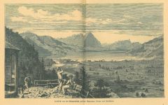
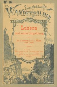 LUZERN. - Luzern - und seine Umgebung.
Zürich, Orell Füssli, ca. 1880.
18 x 12 cm. 32 S. Mit 13 Holzstichen nach J. Weber und 1 Karte. Illustr. OBroschur.
Europäische Wanderbilder Nr. 16. - Mit hübschen Gesamt- und Teilansichten im Text und auf Tafeln. (Artikelnr. 6317BB)
Erfahren Sie mehr48,00 € Inkl. MwSt. -
SCHAFFHAUSEN. - Schaffhausen und der Rheinfall.
Zürich, Orell-Füssli, ca. 1880.
18 x 12 cm. 39 S. Mit 18 Holzstichen nach J. Weber und H. Metzger und 1 Karte. Illustr. OBroschur.
Europäische Wanderbilder Nr. 18. - Mit hübschen Gesamt- und Teilansichten im Text und auf Tafeln. (Artikelnr. 2407BB)
Erfahren Sie mehr56,00 € Inkl. MwSt. -
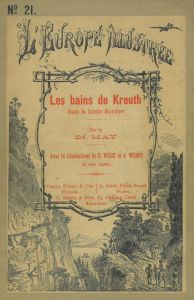 KREUTH. - May, Dr. (F.) - Les bains de Kreuth dans la Haute Baviere.
Zürich, Orell-Füssli, ca. 1880.
18 x 12 cm. 32 S. Mit 14 Holzstichen nach C. Bolze und J. Weber und 1 Karte. Illustr. OBroschur.
Europäische Wanderbilder Nr. 21 (französische Ausgabe). - Mit schönen Ansichten von Kreuth, Königsh... (Artikelnr. 7169BB)
Erfahren Sie mehr65,00 € Inkl. MwSt. -
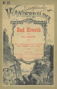 KREUTH. - May, Dr. (F.) - Bad Kreuth im bayrischen Hochgebirge.
Zürich, Orell-Füssli, ca. 1880.
17,5 x 11,5 cm. 32 S. Mit 14 Holzstichen nach C. Bolze und J. Weber und 1 Karte. Illustr. OBroschur.
Europäische Wanderbilder Nr. 22. - Mit schönen Ansichten von Kreuth, Königshaus und -alpe, Hohen... (Artikelnr. 323AB)
Erfahren Sie mehr90,00 € Inkl. MwSt. -
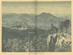
KARLSBAD. - Hardmeyer, J. - Karlsbad.
Zürich, Orell-Füssli, ca. 1890.
18 x 12 cm. 107 S. Mit 57 Holzstichen nach J. Weber. HLwd. d. Zt.
Europäische Wanderbilder Nr. 186, 187 u. 188. - Mit hübschen Gesamt- und Teilansichten im Text und auf Tafeln. - Einband berieben un... (Artikelnr. 2740BB)
Erfahren Sie mehr48,00 € Inkl. MwSt. -
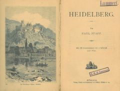 HEIDELBERG. - Pfaff, Karl. - Heidelberg.
Zürich, Orell-Füssli, ca. 1890.
18,5 x 12,5 cm. 72 S., 2 Bl. Mit 35 Holzstichen nach J. Weber und 1 Karte. HLwd. mit mont. VDeckel.
Europäische Wanderbilder Nr. 87 und 88. - Mit hübschen Gesamt- und Teilansichten im Text und auf T... (Artikelnr. 184CB)
Erfahren Sie mehr52,00 € Inkl. MwSt. -
ATLANTIK. - Verkehr. - Verkehrskarte des Atlantischen Ozeans.
Farblithographie nach Scrobel aus Andree bei Velhagen & Klasing, 1893, 36,5 x 47,5 cm.
Espenhorst, PP 5.1.3. - Aus: Richard Andree's "Allgemeiner Handatlas" (3. Ausgabe, Auflage 1893). - Zeigt die Verkehrsströme in und zwischen Afrika, Eu... (Artikelnr. 35537EG)
Erfahren Sie mehr90,00 € Inkl. MwSt. -
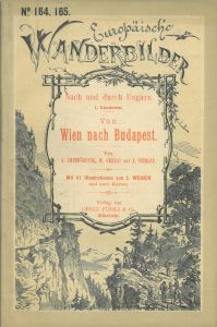 UNGARN. - Immendörfer, A., Gerlai, W. u. Sziklay, J. - Von Wien nach Budapest über Bruck a./L. - Totis (österr.-ung. Staatseisenbahngesellschaft und kgl. ung. Staatsbahnen) und über Marchegg - Pressburg (österr.-ungar. Staatseisenba
Zürich, Orell-Füssli, ca. 1880.
18 x 12 cm. 71 S. Mit 41 Holzstichen nach J. Weber, 1 Plan u. 1 Karte. Illustr. OBrosch.
Europäische Wanderbilder Nr. 164 u. 165. - Nach und durch Ungarn. I. Bändchen. - Mit vielen schönen Gesamt- ... (Artikelnr. 827CB)
Erfahren Sie mehr65,00 € Inkl. MwSt. -
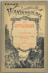 GOTTHARD-PASS. - Hardmeyer, J. - Die Gotthardbahn.
Zürich, Orell-Füssli, ca. 1880.
18 x 12 cm. 112 S. Mit 48 Holzstichen nach J. Weber u. 1 Karte. Illustr. OBrosch.
Europäische Wanderbilder Nr. 30, 31 u. 32. - Die hübschen Ansichten im Text und auf Tafeln, u.a. vom Zuger See, Gold... (Artikelnr. 3244BB)
Erfahren Sie mehr56,00 € Inkl. MwSt. -
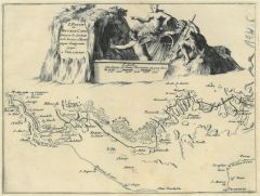
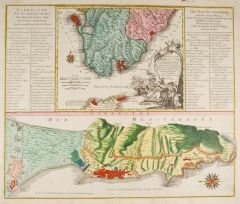
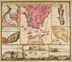 GIBRALTAR. - Accurate Vorstellung der berühmten Meers-Enge bey Gibraltar mit denen herumliegenden See-Haefen und Vestungen so wohl in Prospecten als Grundrissen.
Altkol. Kupferstich bei Homann Erben, um 1740, 48 x 58 cm.
Mittig die Karte der Meerenge von Gibraltar umgebenden von Karten von Cadiz, Ceuta und Gibraltar, Ansichten von Cadiz, Gibraltar und Tanger, sowie eine Karte der Insel Menorca mit ... (Artikelnr. 2679GG)
Erfahren Sie mehr280,00 € Inkl. MwSt. -
KANARISCHE INSELN. - Neue Charte der Canarien Inseln.
Kupferstich nach Bory de St. Vincent, dat. 1803, 18,5 x 45,5 cm.
Die Karte zeigt die gesamten Kanarischen Inseln. - Mit Faltspuren, die rechte untere Ecke fehlt. (Artikelnr. 15671BG)
Erfahren Sie mehr218,00 € Inkl. MwSt. -
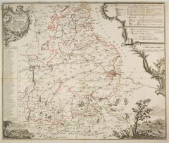
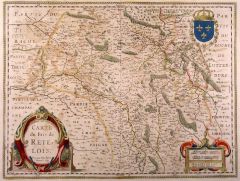 ARDENNEN. - Carte du Pais de Retelois.
Altkol. Kupferstich von Janssonius nach Jubrien, dat. 1641, 38 x 50 cm.
Grenzkolorierte Karte des gesamten Gebiets, mit altkolorierter Rollwerkkartusche, Wappen und Meilenzeiger. Breitrandig, Kolorit teils gering oxydiert. (Artikelnr. 12562BG)
Erfahren Sie mehr124,00 € Inkl. MwSt. -
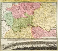
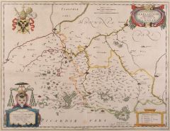 CAMBRAY. - Archiepiscopatvs Cameracensis. Archevesché de Cambray.
Altkol. Kupferstich von W.J. Blaeu nach Burgh, um 1630, 38 x 50 cm.
Grenzkolorierte Karte der Umgebung von Cambray mit zwei altkolorierten Kartuschen und zwei Wappen. Breitrandig und tadellos. (Artikelnr. 12332BG)
Erfahren Sie mehr152,00 € Inkl. MwSt. -
 BAYERN. - Mautkarte. - Geographische Mauth-Charte von Bayern. Vorstellend alle zu Wasser und zu Land hergebrachte Mauth-Stationen.
Grenzkol. Kupferstich von Tobias Conrad Lotter nach Johann Franz Kohlbrenner, dat. 1764, 55,5 x 65,5 cm.
Mappa Bavariae S. 17, Abb. 12. - Die Karte des Münchner Registraturbeamten Johann Franz Kohlbrenner (1728-1783) ist die erste Mautkar... (Artikelnr. 16257CG)
Erfahren Sie mehr650,00 € Inkl. MwSt. -
NORD. - Tracht. - Habitants. Einwohner von Département du Nord.
Altkol. Aquatinta, um 1795, 9 x 13,5 cm.
Aus der Reihe: "Voyage dans les Departements de la France" von Joseph La Vallée, Marquis de Bois-Robert (1747 - 1816), Paris, 1793-1800. Die Karte zeigt das die Umgebung von Lille, Douai und Cambra... (Artikelnr. 19617AG)
Erfahren Sie mehr24,00 € Inkl. MwSt. -
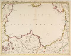 SCHWARZES MEER. - Seconde Partie de la Crimée, la Mer Noire.
Altkol. Kupferstich bei Covens & Mortier, Amsterdam, um 1730, 47 x 61 cm.
Die flächenkolorierte Karte zeigt das Schwarze Meer und einen kleinen Teil der Halbinsel Krim, sowie der Türkei, Bulgarien, Armenien, Rumänien und Rußland. - In ... (Artikelnr. 2825GG)
Erfahren Sie mehr340,00 € Inkl. MwSt. -
 TÜRKEI. - Jouannin, J.M. und Jules van Gaver. - Turquie.
Paris, Didot, 1840.
20,5 x 13 cm. 2 Bl., 460 S., 2 Bl. Mit 95 (davon 1 gefalt.) Stahlstichtafeln und 2 gefalt. Karten bzw. Plänen. Mod. HLwd. unter Verwendung des alten Rtit.
Die Tafeln mit verschiedenen Ansichten, Trachten- und Genr... (Artikelnr. 7550BB)
Erfahren Sie mehr250,00 € Inkl. MwSt. -
GENF. - Ansicht des Hôtel du Lac, rechts Segelboote und Raddampfer. Geschäftskarte.
Lithographie von Kocher, um 1850, 6,5 x 14 cm.
Sehr dekorative Karte, im unteren Rand Werbetext; auf braunem Karton altmontiert. (Artikelnr. 5513CG)
Erfahren Sie mehr86,00 € Inkl. MwSt. -
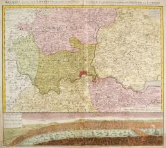 LONDON. - Ausführliche Geographische Vorstellung der Gegend um London nach Anleitung des Engl. Originals so Th. Bowles in London edirt, herausgegeben von Homann Erben 1741. Umgebungskarte von London, darunter Gesamtansicht über die Them
Altkol. Kupferstich von Homann Erben, dat. 1741, 49 x 56 cm.
Die flächenkolorierte Karte mit Kopftitel. Auch die Gesamtansicht in zartem Altkolorit. - Einriss von unten sorgfältig restauriert, Ränder etwas unfrisch. (Artikelnr. 22285CG)
Erfahren Sie mehr1.100,00 € Inkl. MwSt. -
 GIBRALTAR. - Castellum Gibraltar in Andalusia situm, cum celebri Freto inter Europam et Africam, annexis circumjacentibus Portubus et Castellis.
Altkol. Kupferstich bei Tobias Conrad Lotter, um 1755, 48 x 58 cm.
Zeigt die Halbinsel Gibraltar, darüber Karte von Südspanien von Cadiz bis Marbella mit der Meerenge von Gibraltar und der Nordspitze Afrikas mit den Städten Ceuta und Ta... (Artikelnr. 2680GG)
Erfahren Sie mehr550,00 € Inkl. MwSt. -
 LONDON. - Ausführliche Geographische Vorstellung der Gegend um London nach Anleitung des Engl. Originals so Th. Bowles in London edirt, herausgegeben von Homann Erben 1741. Umgebungskarte von London, darunter Gesamtansicht über die Them
Altkol. Kupferstich bei Homann Erben, dat. 1741, 49 x 56 cm.
Die flächenkolorierte Karte mit Kopftitel. Die Gesamtansicht nicht koloriert. - Rand oben und links knapp. - Dekoratives Blatt in kräftigem Altkolorit. (Artikelnr. 26286CG)
Erfahren Sie mehr900,00 € Inkl. MwSt. -
 ATLANTEN. - Wagner, Hermann (Hrsg.). - Sydow-Wagners methodischer Schul-Atlas. Entworfen, bearbeitet und herausgegeben.
Gotha, Perthes, 1893.
5. durchgesehene und berichtigte Aufl. 31,5 x 37 cm. Titel, 7 Bl. Mit 60 Haupt- und 50 Nebenkarten auf 44 Tafeln, alles in Farblithographie. Mod. Pp.-Mappe.
Espenhorst, AS, 38.3. - "Ab 1888 erschien eine auf 44 K... (Artikelnr. 6505BB)
Erfahren Sie mehr240,00 € Inkl. MwSt. -
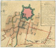 MIRANDOLA. - Relation der Belagerung von Mirandola, 1642 usw. Grundriß der befestigten Stadt, davor die Aufstellung der österreichisch-sardinischen und der spanischen Truppen, rechts oben Erklärungen a - y.
Altkol. Kupferstich bei Homann Erben, 1743, 24 x 28 cm.
Aus der vierteiligen "Kriegs-Expeditions-Karte in Italien a(nno) 1742 u(nd) 1743" usw. - Bis zur Einfassungslinie beschnitten. (Artikelnr. 34487EG)
Erfahren Sie mehr90,00 € Inkl. MwSt. -
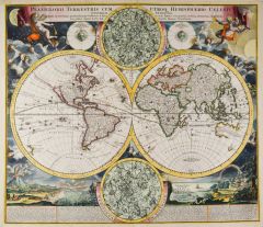 WELTKARTE und die vier Erdteile. - Planiglobii terrestris cum utroq Hemisphaerio Caelesti. Weltkarte in zwei Hemisphären, umgeben von zwei Sternenkarten, geographischen und figürlichen Darstellungen und gestochenen Erklärungen. - Dabei
5 altkolorierte Kupferstiche von Johann Baptist Homann, um 1720, je ca. 48 x 55 cm.
Weltkarte in zwei Hemisphären, umgeben von zwei Sternenkarten, geographischen und figürlichen Darstellungen und gestochenen Erklärungen, alles in schön... (Artikelnr. 25268CG)
Erfahren Sie mehr5.500,00 € Inkl. MwSt. -
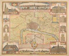 ANTWERPEN. - Marchionatus Sacri Romani Imperii. Grundriß von Antwerpen, umgeben von 3 Gesamtansichten aus verschiedenen Richtungen und 10 Teilansichten.
Altkol. Kupferstich von Nicolas Visscher nach Claes Jansz Visscher, 1684, 46 x 56 cm.
Aus dem 1684 erschienenen Atlas "Germaniae Inferiori". - Die Teilansichten zeigen u.a. Kathedrale, Rathaus, Börse, Hansehaus und verschiedene Kirchen. M... (Artikelnr. 28544CG)
Erfahren Sie mehr1.400,00 € Inkl. MwSt. -
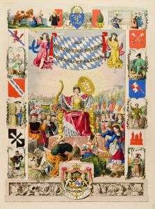 BAYERN. - Lommel, Georg und Gottlieb J. Bauer. - Das Königreich Bayern in seinen acht Kreisen.
Ca. 1840.
2. Aufl. 43 x 34 cm. Altkolor. Kupfertitel und 8 altkolor. Kupfertafeln von F. Würthle und J.P. Walther nach Kreul. 1 Bl. Erklärung, 10, 7, 9, 10 S., 9 Bl., 12 S., 11 Bl., 9 S. HLdr. d. Zt. mit Rsch.
Pfister II, 2935; Lipp... (Artikelnr. 1998CB)
Erfahren Sie mehr2.250,00 € Inkl. MwSt.