Suchergebnisse für: "europa karte"
-
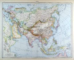
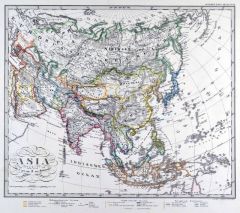
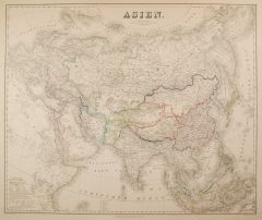 ASIEN. - Karte. - Asien. Gesamtkarte.
Grenzkol. Kupferstich von Jungmann nach Kiepert, Weimar im Geograph. Institut, 1876, 52,5 x 63 cm.
Espenhorst, AS, 1.1.6. - Zeigt Europa, Asien mit Japan, Philippinen, Indonesischer Inselwelt und Nordwestaustralien, dazu das nordöstliche ... (Artikelnr. 32592EG)
Erfahren Sie mehr118,00 € Inkl. MwSt. -
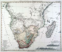 SÜDAFRIKA. - Karte. - Süd-Africa mit Madagascar.
Grenzkol. Kupferstich nach Berghaus aus Stieler bei Perthes, Gotha, dat. 1864, 32 x 39 cm.
Aus: A. Stieler's "Hand-Atlas". - Mit Einzeichnung der Reiserouten europäischer Forscher und zwei Höhenprofilen. (Artikelnr. 18038CG)
Erfahren Sie mehr85,00 € Inkl. MwSt. -
WELTKARTE. - Klimakarte. - Isothermen der Erde. Verbreitung der Vulkane. Verbreitung der Baum- und Strauchgewächse und der Kulturgewächse in Europa. Insgesamt vier Karten auf einem Blatt.
Grenzkol. Kupferstich von Dellinger nach Gräf, Weimar im Geograph. Institut, 1872, 48,5 x 61,5 cm.
Espenhorst, PP 1.1.6. - Aus: Heinrich Kiepert's "Grosser Hand-Atlas" (43. Ausgabe, Auflage 1872). - Gewann 1871 die einzige Goldmedaille au... (Artikelnr. 35211EG)
Erfahren Sie mehr110,00 € Inkl. MwSt. -
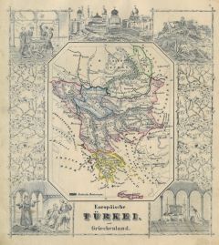 TÜRKEI. - Karte. - Europäische Türkei und Griechenland. Gesamtkarte (13,5 x 11 cm), umgeben von Ansichten und landestypischen Szenen.
Grenzkol. Kupferstich bei J. Berlin, 1853, 16 x 20,5 cm.
Espenhorst, PP 63,5. - Im Rand gering unfrisch. (Artikelnr. 27136CG)
Erfahren Sie mehr120,00 € Inkl. MwSt. -
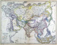
 ASIEN. - Karte. - Asien.
Farblithographie aus Andree bei Velhagen & Klasing, 1881, 37 x 46,5 cm.
Espenhorst, PP 5.1.1. - Aus: Richard Andree's "Allgemeiner Handatlas" (1. Ausgabe, Auflage 1881). - Zeigt im Westen Europa, Ägypten und Somalia, im Osten die Beringst... (Artikelnr. 35338EG)
Erfahren Sie mehr95,00 € Inkl. MwSt. -
ASIEN. - Karte. - Übersichtskarte von Asien.
Farblithographie nach Scrobel aus Andree bei Velhagen & Klasing, 1900, 36,5 x 46,5 cm.
Espenhorst, PP 5.1.4. - Aus: Richard Andree's "Allgemeiner Handatlas" (4. Ausgabe, Auflage 1900). - Zeigt Europa, Asien mit Japan, Philippinen, Indonesi... (Artikelnr. 745FG)
Erfahren Sie mehr120,00 € Inkl. MwSt. -
ASIEN. - Karte. - Übersichtskarte von Asien.
Farblithographie nach Scrobel aus Andree bei Velhagen & Klasing, 1893, 36,5 x 46,5 cm.
Espenhorst, PP 5.1.3. - Aus: Richard Andree's "Allgemeiner Handatlas" (3. Ausgabe, Auflage 1893). - Zeigt das Gebiet von Europa bis Nordaustralien. (Artikelnr. 34948EG)
Erfahren Sie mehr110,00 € Inkl. MwSt. -
 IRLAND. - Karte. - Gesamtkarte mit dem westlichen England, in zwei Teilen.
2 Mehrfarbendrucke in Typometrie von Raffelsberger bei Bermann, 1843, je ca. 34 x 51 cm.
Aus "Erste typometrische General-Karte von Europa", Wien, 1843. - Der nördliche Kartenteil zeigt neben Nordirland (Ulster) das westliche Schottland u... (Artikelnr. 588FG)
Erfahren Sie mehr220,00 € Inkl. MwSt. -
 GRIECHENLAND. - Karte. - Griechenland mit Ägäis und westlicher Türkei.
Mehrfarbendruck in Typometrie von F. Raffelsberger bei J. Bermann, Wien, 1843, 34 x 52,5 cm.
Aus "Erste typometrische General-Karte von Europa", Wien, 1843. - Gesamtkarte mit Albanien und Montenegro im Nordwesten, im Norden Makedonien, Rum... (Artikelnr. 584FG)
Erfahren Sie mehr180,00 € Inkl. MwSt. -
ALPEN. - Karte. - Südliches Mitteleuropa mit Zentrum Schweiz und Österreich, dazu Südostfrankreich, Süddeutschland, Norditalien und Slowenien.
Mehrfarbendruck in Typometrie von F. Raffelsberger bei J. Bermann, Wien, 1843, 34 x 52 cm.
Aus "Erste typometrische General-Karte von Europa". - Begrenzungen: Im Westen die Linie Paris-Clermont-Montpellier-Collioure; im Norden Paris-Mannhe... (Artikelnr. 31937EG)
Erfahren Sie mehr220,00 € Inkl. MwSt. -
ASIEN. - Karte. - Asien (physikalisch). Gesamtkarte.
Farblithographie nach Loreck und Winter bei Piloty & Loehle, 1899, 36 x 47 cm.
Aus: "Atlas für die Bayerischen Mittelschulen". - Zeigt im Westen Europa und Nordostafrika, im Südosten die Indonesische Inselwelt. Südwesten die Afrikanisch... (Artikelnr. 32923EG)
Erfahren Sie mehr80,00 € Inkl. MwSt. -
ASIEN. - Karte. - Asien (politisch). Gesamtkarte.
Farblithographie nach Loreck und Winter bei Piloty & Loehle, 1899, 36 x 47 cm.
Aus: "Atlas für die Bayerischen Mittelschulen". - Zeigt im Westen Europa und Nordostafrika, im Südosten die Indonesische Inselwelt. Südwesten die Afrikanisch... (Artikelnr. 32924EG)
Erfahren Sie mehr100,00 € Inkl. MwSt. -
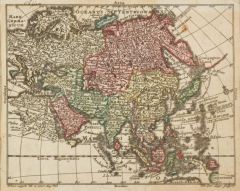
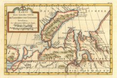
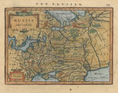 RUSSLAND. - Karte. - Russia cum Confinijs.
Altkol. Kupferstich von Janssonius, um 1630, 14 x 18 cm.
Das europäische Rußland mit Skandinavien, im Osten bis zum Ural bzw. Ob, im Süden bis zur Krim, unten Meilenanzeiger und Inschriftenkartusche. - Gleichmäßig gebräunt. (Artikelnr. 1682GG)
Erfahren Sie mehr140,00 € Inkl. MwSt. -
ASIEN. - Karte. - Asia. Gesamtkarte.
Grenzkol. Kupferstich nach Stülpnagel und Berghaus aus Stieler bei Perthes, Gotha, 1866, 30 x 35,5 cm.
Espenhorst, PP 2.1.1.1.4. - Aus: A. Stieler's "Hand-Atlas" (4. Ausgabe, Auflage 1866). - Zeigt das Gebiet von der Europäischen Türkei... (Artikelnr. 34909EG)
Erfahren Sie mehr60,00 € Inkl. MwSt. -
 ASIEN. - Karte. - Asia. Gesamtkarte.
Grenzkol. Kupferstich nach Stülpnagel aus Stieler bei Perthes, Gotha, 1875, 30 x 35,5 cm.
Espenhorst, PP 2.1.1.1.6. - Aus: A. Stieler's "Hand-Atlas" (6. Ausgabe, Auflage 1875). - Zeigt das Gebiet von der Europäischen Türkei im Nordweste... (Artikelnr. 35389EG)
Erfahren Sie mehr95,00 € Inkl. MwSt. -
INDIEN. - Karte. - Vorderindien. Mit Nebenkarte: Inselkette der Malediven.
Grenzkol. Kupferstich nach Weiland, Weimar im Geograph. Institut, dat. 1827, 60,5 x 53,5 cm.
Espenhorst, PP 1.1.2. - Zeigt das Gebiet zwischen der Indusmündung und Birma. Mit Farberklärungen für indische Fürstentümer und Europäische ... (Artikelnr. 33052EG)
Erfahren Sie mehr118,00 € Inkl. MwSt. -
 ASIEN. - Karte. - Asien. Gesamtkarte.
Grenzkol. Lithographie von Sulzer aus Kiepert bei Reimer, 1875, 33,5 x 43 cm.
Espenhorst, PP 20.3.2. - Aus: Heinrich Kiepert's "Kleiner Hand-Atlas der Neueren Geographie für Schule und Haus" (Ausgabe 1875). - Zeigt im Westen Europa, im Os... (Artikelnr. 35296EG)
Erfahren Sie mehr100,00 € Inkl. MwSt. -
ASIEN. - Karte. - Asien, Physische Übersicht. Gesamtkarte.
Farblithographie nach Wolf aus Spamer, 1902, 31,5 x 41,5 cm.
Espenhorst, PP 23.2. - Aus: O. Spamer's "Grosser Hand-Atlas" (2. Ausgabe, Auflage 1902). - Zeigt das Gebiet von Europa bis Neuguinea, in Flächenfarben: Unter dem Meeresspiegel, ... (Artikelnr. 35104EG)
Erfahren Sie mehr80,00 € Inkl. MwSt. -
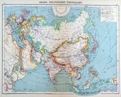 ASIEN. - Karte. - Asien, Politische Übersicht. Gesamtkarte.
Farblithographie nach Wolf aus Spamer, 1902, 31,5 x 41,5 cm.
Espenhorst, PP 23.2. - Aus: O. Spamer's "Grosser Hand-Atlas" (2. Ausgabe, Auflage 1902). - Zeigt das Gebiet von Europa bis Neuguinea, die Staatsgrenzen farbig. - Verso Typographi... (Artikelnr. 35105EG)
Erfahren Sie mehr100,00 € Inkl. MwSt. -
 ERDTEILE. - Karten. - Die 4 Kontinente (Afrika, Amerika, Asien und Europa) in hübschen, kleinen Landkarten.
4 altkol. Kupferstiche von Tobias Lobeck bei Tobias Conrad Lotter, um 1750, 9,5 x 12 cm (einzeln gerahmt). (Artikelnr. 18726BG)
Erfahren Sie mehr480,00 € Inkl. MwSt. -
 RUSSLAND. - Karte. - Empire de Russie en Europe.
Kupferstich von J. Balconi, um 1750, 41,5 x 49 cm.
Das europäische Rußland mit Schweden, im Osten bis zum Ural bzw. Ob, im Süden bis zum Schwarzen bzw. Kaspischen Meer. - Mehrfach gefaltet, leicht stockfleckig. (Artikelnr. 1684GG)
Erfahren Sie mehr220,00 € Inkl. MwSt. -
INDIEN. - Karte. - Vorderindien. Mit Nebenkarte: Inselkette der Malediven.
Grenzkol. Kupferstich nach Weiland, Weimar im Geograph. Institut, dat. 1850, 61 x 54,5 cm.
Espenhorst, PP 1.1.4. - Zeigt das Gebiet zwischen der Beludschistan und Birma. Mit Farberklärungen für indische Fürstentümer und Europäische Be... (Artikelnr. 33170EG)
Erfahren Sie mehr118,00 € Inkl. MwSt. -
INDIEN. - Karte. - Vorderindien. Mit Nebenkarte: Inselkette der Malediven.
Grenzkol. Kupferstich nach Weiland, Weimar im Geograph. Institut, dat. 1838, 61 x 53 cm.
Espenhorst, PP 1.1.3. - Zeigt das Gebiet zwischen der Beludschistan und Birma. Mit Farberklärungen für indische Fürstentümer und Europäische Besi... (Artikelnr. 676FG)
Erfahren Sie mehr118,00 € Inkl. MwSt. -
TÜRKEI. - Karte. - Das gesammte Osmanische Reich so wie die Besitzungen des Pascha's von Ägypten in Europa, Asia und Africa.
Grenzkol. Kupferstich von Maedel nach Weiland, Weimar im Geograph. Institut, dat. 1839, 48,5 x 61,5 cm.
Espenhorst, PP 1.1.3. - Zeigt auch "Griechenland, Iran, Afghanistan, Beludschistan, Turan und Arabien, nebst angrenzenden Theilen von O... (Artikelnr. 669FG)
Erfahren Sie mehr138,00 € Inkl. MwSt. -
AFRIKA. - Karte. - Übersichtskarte von Afrika, mit der Arabischen Halbinsel. Mit zwei Nebenkarten.
Farblithographie nach Scrobel aus Andree bei Velhagen & Klasing, 1900, 36,5 x 46,5 cm.
Espenhorst, PP 5.1.4. - Aus: Richard Andree's "Allgemeiner Handatlas" (4. Ausgabe, Auflage 1900). - Die Europäischen Kolonialbesitzungen mit Flächenko... (Artikelnr. 753FG)
Erfahren Sie mehr100,00 € Inkl. MwSt. -
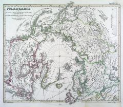 NORDPOL. - Karte. - Polar-Karte enthaltend: die Länder u. Meere vom Nord Pol bis 50° N.Br. u. weiter, mit der Übersicht des Russischen Reiches in Europa, Asia u. America.
Grenzkol. Kupferstich von Poppey aus Stieler bei Perthes, Gotha, dat. 1850, 31 x 37,5 cm.
Espenhorst, PP 2.1.1.1.2. - Aus: A. Stieler's "Hand-Atlas" ("Second Edition"). - Oben und unten etwas wasserrandig. (Artikelnr. 33237EG)
Erfahren Sie mehr90,00 € Inkl. MwSt. -
95,00 € Inkl. MwSt.
-
86,00 € Inkl. MwSt.
-
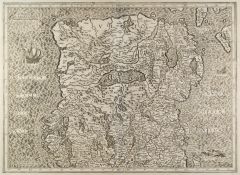
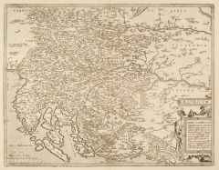 KROATIEN. - Karte. - Illyricum. Karte der ehemaligen römischen Provinz Illyrien.
Kupferstich von Abraham Ortelius, dat. 1572, 37 x 47,5 cm.
Van den Broecke 144. - Die Karte zeigt das Gebiet von Ungarn bis Dalmatien. - Gut erhalten. (Artikelnr. 2094GG)
Erfahren Sie mehr480,00 € Inkl. MwSt. -
 ITALIEN. - Norditalien. - Karte. - Strategische Karte des Festungs-Vierecks Peschiera, Verona, Mantua, Legnago.
Lithographie bei Schreiber, Esslingen, 1859, 32 x 46 cm.
Beilage zu "Über Land und Meer". Detaillierte Karte des Kriegsschauplatzes von 1859. - Längs- und Querfalten. (Artikelnr. 14419CG)
Erfahren Sie mehr80,00 € Inkl. MwSt. -
 SIBIRIEN. - Karte. - Verfolg der Karte von Sibirien und des Landes Kamtschatka.
Altkol. Kupferstich, um 1770, 23 x 25 cm.
Die Karte zeigt das östliche Sibirien, sowie Kamtschatka, im Süden noch die Insel Sachalin. - Mit geglätteten Faltspuren. (Artikelnr. 2704GG)
Erfahren Sie mehr120,00 € Inkl. MwSt. -
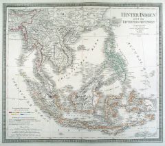 ASIEN. - Südostasien. - Karte. - Hinterindien nebst den Hinterindischen Inseln.
Grenzkol. Kupferstich nach Weiland/Kiepert, Weimar im Geograph. Institut, dat. 1857, 49,5 x 56,5 cm.
Espenhorst, PP 1.1.5. - Gebietskarte mit Malaysia, Indochina, Taiwan, Indonesien und Philippinen. Mit Farberklärungen für die Europäisc... (Artikelnr. 33171EG)
Erfahren Sie mehr148,00 € Inkl. MwSt. -
AFRIKA. - Karte. - Afrika (physikalisch). Gesamtkarte, mit sechs Nebenkarten.
Farblithographie nach Loreck und Winter bei Piloty & Loehle, 1899, 35,5 x 48 cm.
Aus: "Atlas für die Bayerischen Mittelschulen". - Zeigt im Norden das südliche Europa mit dem Türkischen Reich. Die Nebenkarten zeigen das Deutsche Reich u... (Artikelnr. 32926EG)
Erfahren Sie mehr100,00 € Inkl. MwSt. -
AFRIKA. - Karte. - Afrika (politisch). Gesamtkarte, mit acht Nebenkarten.
Farblithographie nach Loreck und Winter bei Piloty & Loehle, 1899, 35 x 48 cm.
Aus: "Atlas für die Bayerischen Mittelschulen". - Zeigt im Norden das südliche Europa mit dem Türkischen Reich. Die Nebenkarten zeigen das Deutsche Reich und... (Artikelnr. 32925EG)
Erfahren Sie mehr120,00 € Inkl. MwSt. -
 IRLAND. - Nordirland. - Karte. - Karte des Gebietes nördlich von Galway und Dublin.
Kupferstich von G. Mercator, um 1580, 35 x 47 cm.
Überaus detaillierte Karte mit Segelschiff und Seeungeheuer im Kartenbild. (Artikelnr. 25692CG)
Erfahren Sie mehr350,00 € Inkl. MwSt. -
 SIBIRIEN. - Karte. - Karte von Sibirien und den benachbarten Laendern.
Altkol. Kupferstich nach Bellin, um 1750, 28 x 45 cm.
Die Karte zeigt Russland, im Westen der Ladogasee, im Osten bis China. (Artikelnr. 2710GG)
Erfahren Sie mehr160,00 € Inkl. MwSt. -
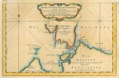 WAIGATSCH. - Karte. - Karte von der Strass Waigats oder Nassau.
Altkol. Kupferstich nach Bellin, um 1770, 19 x 30 cm.
Die Karte zeigt die Meerenge zwischen der Insel Waigatsch und dem Festland. (Artikelnr. 2711GG)
Erfahren Sie mehr100,00 € Inkl. MwSt. -
ASIEN. - Karte. - Asien. Gesamtkarte.
Grenzkol. Kupferstich von Maedel nach Weiland, Weimar im Geograph. Institut, dat. 1829, 54,5 x 58,5 cm.
Espenhorst, PP 1.1.2. - Zeigt das Gebiet zwischen Ägäis und Rotem Meer im Westen bis Nordaustralien im Südosten und den Aleuten im N... (Artikelnr. 33049EG)
Erfahren Sie mehr140,00 € Inkl. MwSt. -
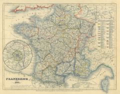 FRANKREICH. - Karte. - Frankreich 1849 mit Karte der Umgebung von Paris.
Grenzkol. Stahlstich aus Meyer's Zeitungsatlas, 1853, 19,5 x 26 cm. (Artikelnr. 85CG)
Erfahren Sie mehr48,00 € Inkl. MwSt. -
 NOWAJA SEMLJA. - Karte. - Karte derer Laender welche die Samojeden und Ostiaken bewohnen.
Altkol. Kupferstich, um 1780, 15 x 23,5 cm.
Die Karte zeigt die Insel Nowaja Semlja im Eismeer und Teile von Nordwest-Russland. (Artikelnr. 2703GG)
Erfahren Sie mehr80,00 € Inkl. MwSt. -
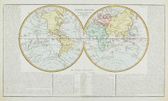 WELTKARTE und die vier Erdteile. - Mappe - Monde. Suivant les Nouvelles Observations. Weltkarte in zwei Hemisphären, umgeben gestochenen Erklärungen. - Dabei: Gesamtkarten von Europa, Amerika, Asien und Afrika.
5 altkolorierte Kupferstiche von Mr. Abbé Clouet, dat. 1787, je ca. 32 x 55 cm.
Schöne, wohl erhaltene Folge dieser französischen Karten. (Artikelnr. 25460CG)
Erfahren Sie mehr950,00 € Inkl. MwSt. -
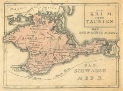 KRIM. - Karte. - Die Krim oder Taurien. Karte der Halbinsel.
Altkol. Kupferstich von G. Bodenehr, um 1730, 16 x 23 cm. - Minimal fleckig. (Artikelnr. 42344EG)
Erfahren Sie mehr120,00 € Inkl. MwSt. -
 ITALIEN. - Mittelitalien. - Karte. - Italia superior. Mit Korsika und kleiner Karte von Rom.
Grenzkol. Stahlstich aus Meyer's Zeitungsatlas, 1853, 19 x 25 cm. (Artikelnr. 356AG)
Erfahren Sie mehr45,00 € Inkl. MwSt. -
RUSSLAND. - Karte. - Carte Physique & Politique de la Russie et de la Pologne.
Grenzkol. Kupferstich von Marlier aus Dussieux bei Lecoffre, dat. 1845, 38,5 x 27 cm.
Aus: Louis Dussieux's "Atlas Général de Géographie". - Zeigt das Europäische Rußland bis zum Ural. - In den Ecken links leicht wasserrandig. (Artikelnr. 34811EG)
Erfahren Sie mehr75,00 € Inkl. MwSt. -
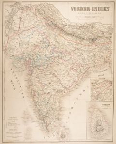 INDIEN. - Karte. - Vorder Indien.
Grenzkol. Kupferstich von Haubold nach Gräf, Weimar im Geograph. Institut, dat. 1861, 65 x 51,5 cm.
Espenhorst, PP 1.1.5. - Aus: Kiepert, "Hand-Atlas", 42. Ausgabe (1856/69). - Gesamtkarte mit Erklärungen und zwei Nebenkarten von Ceylon... (Artikelnr. 17093AG)
Erfahren Sie mehr95,00 € Inkl. MwSt. -
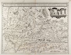 SALZBURG. - Karte. - Saltzburg Archiepiscopatus, et Carintha Ducatus.
Kupferstich von Mercator bei Blaeu, um 1630, 38 x 50 cm.
Sehr dekorative Karte mit schöner Wappenkartusche. Breitrandig. (Artikelnr. 25689CG)
Erfahren Sie mehr350,00 € Inkl. MwSt. -
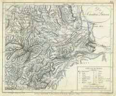 LUZERN. - Karte. - Der Canton Luzern. Schöne Kantons- Karte von Aarwangen bis Rothorn und Schwyz.
Kupferstich von Scheurman nach Pfyffer, um 1840, 22 x 26,5 cm. (Artikelnr. 10141AG)
Erfahren Sie mehr130,00 € Inkl. MwSt.