Suchergebnisse für: "europa karte"
-
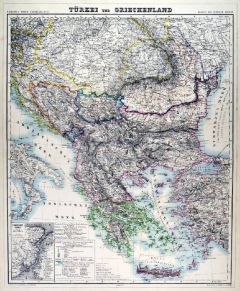
GRIECHENLAND. - Karte. - Türkei und Griechenland.
Grenzkol. Lithographie von Kraatz aus Kiepert bei Reimer, Berlin, 1858, 54 x 43,5 cm.
Espenhorst, PP 20.1.1. - Aus: Heinrich Kiepert's "Neuer Handatlas über alle Theile der Erde" (Ausgabe 1858). - Gesamtkarte von Griechenland mit dem euro... (Artikelnr. 19029BG)
Erfahren Sie mehr100,00 € Inkl. MwSt. -
ASIEN. - Südostasien. - Karte. - Hinterindien nebst den Hinterindischen Inseln.
Grenzkol. Stahlstich nach C.F. Weiland beim Geograph. Institut, Weimar, dat. 1840, 49 x 55 cm.
Gebietskarte mit Malaysia, Indochina, Taiwan, Indonesien und Philippinen, mit Titel, Maßstab und Erklärungen. Das Grenzkolorit zeigt die Europ... (Artikelnr. 31969EG)
Erfahren Sie mehr180,00 € Inkl. MwSt. -
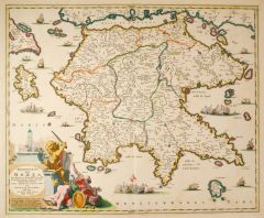 GRIECHENLAND. - Peloponnes. - Karte. - Peloponnesus hodie Morea. Gesamtkarte der Halbinsel.
Altkol. Kupferstich bei Nicolas Visscher, um 1700, 45,5 x 55,5 cm.
Teilkolorierte Karte mit großer, altkolorierter Titelkartusche mit Figuren und einem kämpfenden Löwen mit Schwert. Die dekorative Karte mit eingezeichneten Schiffen und ... (Artikelnr. 20191BG)
Erfahren Sie mehr450,00 € Inkl. MwSt. -
 KROATIEN. - Karte. - Illyricum. Karte der ehemaligen römischen Provinz Illyrien.
Altkol. Kupferstich von Abraham Ortelius, dat. 1572, 37 x 47,5 cm.
Die flächenkolorierte Karte zeigt das Gebiet von Ungarn bis Dalmatien. - Am Rand oben ein hinterlegter Einriss, rechts unten im Eck und verso alte hs. Notizen. (Artikelnr. 1762GG)
Erfahren Sie mehr580,00 € Inkl. MwSt. -
EUROPA. - Mittelmeer. - Karte. - Die Mittelmeerländer.
Farblithographie nach Wolf aus Spamer, 1902, 31,5 x 41,5 cm.
Espenhorst, PP 23.2. - Aus: O. Spamer's "Grosser Hand-Atlas" (2. Ausgabe, Auflage 1902). - Zeigt das Gebiet von Berlin bis Hamada von Mursuk, von Lissabon bis Damaskus, in je 7 F... (Artikelnr. 35095EG)
Erfahren Sie mehr90,00 € Inkl. MwSt. -
 LOTHRINGEN. - Karte. - Lorraine. Lotharingiae nova descriptio.
Altkol. Kupferstich von Ortelius, dat. 1587, 34 x 50 cm.
Flächenkolorierte Karte des gesamten Gebiets mit drei altkolorierten Rollwerkkartuschen. (Artikelnr. 193AG)
Erfahren Sie mehr180,00 € Inkl. MwSt. -
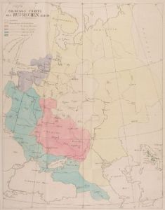 RUSSLAND. - Karte. - Bildungscharte des Russischen Reichs. Das europäische Russland von Lappland bis Tiflis, vom Bug bis zum 80. Längengrad (Grenze zu Sibirien).
Grenzkol. Kupferstich bei Cotta, Tübingen, 1806, 36 x 28 cm.
Mit vierseitigen Erläuterungen. - Mit Längs- und Querfalten. (Artikelnr. 19703EG)
Erfahren Sie mehr57,00 € Inkl. MwSt. -
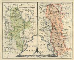 AARGAU. - Karte. - Die Freyen Aemer. Die Grafschaft Baden Nro. 426. Zwei Karten nebeneinander.
Altkol. Kupferstich von Reilly, um 1790, 21 x 29 cm.
Zweigeteilte Karte mit der Umgebung von Basel, rechts der Rhein zwischen Fort Louis und Kehl. (Artikelnr. 28537CG)
Erfahren Sie mehr220,00 € Inkl. MwSt. -
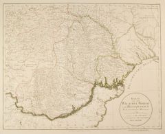 WALACHAI. - Karte. - Karte von der Walachei, Moldau und Bessarabien. Nach geometrischen Messungen und astronomischen Beobachtungen.
Kupferstich von J.F. Schmid bei F.A. Schraembl, dat. 1787, 45 x 57,5 cm.
Die Karte zeigt Moldavien und die Walachei mit den angrenzenden Ländern. (Artikelnr. 2411GG)
Erfahren Sie mehr340,00 € Inkl. MwSt. -
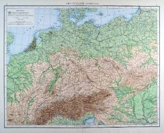 DEUTSCHLAND. - Karte. - Deutschland. Physikalisch.
Farblithographie aus Andree bei Velhagen & Klasing, 1881, 36,5 x 46,5 cm.
Espenhorst, PP 5.1.1. - Aus: Richard Andree's "Allgemeiner Handatlas" (1. Ausgabe, Auflage 1881). - Verso 9 weitere Darstellungen: Isothermen- und Windkarte der Erde... (Artikelnr. 35326EG)
Erfahren Sie mehr95,00 € Inkl. MwSt. -
 GRIECHENLAND. - Karte. - Türkei und Griechenland.
Grenzkol. Kupferstich von Herzberg und Brose aus Kiepert bei Reimer, Berlin, 1875, 54 x 43,5 cm.
Espenhorst, PP 20.1.2. - Aus: Heinrich Kiepert's "Neuer Handatlas über alle Theile der Erde" (Ausgabe 1875). - Berichtigt 1874. - Gesamtkarte... (Artikelnr. 19048BG)
Erfahren Sie mehr100,00 € Inkl. MwSt. -
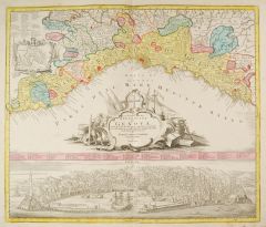 GENUA. - Lo Stato della Repubblica di Genova. Karte der Republik, darunter große Gesamtansicht vom Meer aus (13 x 56 cm).
Altkol. Kupferstich von Tobias Conrad Lotter, um 1740, 49 x 56 cm.
Die flächenkolorierte Karte zeigt die Küste zwischen Ventimiglia und La Spezia. Mit prächtiger Titelkartusche, kleinem Stadtplan in gestochener Umrandung und gestochenen... (Artikelnr. 9353CG)
Erfahren Sie mehr900,00 € Inkl. MwSt. -
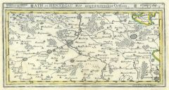 ATH. - Karte. - Ath in Hennegau Mitt angraenzenden Orthen.
Altkol. Kupferstich von Bodenehr, um 1720, 16 x 30 cm.
Die grenzkolorierte Karte zeigt Ath und seine Umgebung. (Artikelnr. 14854BG)
Erfahren Sie mehr66,00 € Inkl. MwSt. -
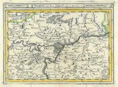 NAMUR. - Karte. - Namur mit dero Gegend auff 2 Stunden.
Altkol. Kupferstich von Bodenehr, um 1720, 16,5 x 23 cm.
Die grenzkolorierte Karte zeigt Namur mit seiner Umgebung. (Artikelnr. 14841BG)
Erfahren Sie mehr62,00 € Inkl. MwSt. -
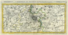 TOURNAI. - Karte. - Dorneck oder Tournay Mitt Naheanligender Gegend.
Altkol. Kupferstich von Bodenehr, um 1720, 15 x 29,5 cm.
Die grenzkolorierte Karte zeigt Tournai mit seiner Umgebung. (Artikelnr. 14839BG)
Erfahren Sie mehr66,00 € Inkl. MwSt. -
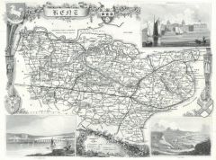 KENT. - Karte. - Kent. Karte der Grafschaft mit 3 Ansichten (Greenwich, Rochester, Dover) und Wappeneinfassungen.
Kupferstich, um 1820, 19 x 25,5 cm.
Oben hinterlegter Eckausriß mit geringem Bildverlust beim Wappen. (Artikelnr. 23147CG)
Erfahren Sie mehr68,00 € Inkl. MwSt. -
 TURIN. - Karte. - Die Gegend von Turin bis Cres Centin.
Altkol. Kupferstich von Bodenehr, um 1720, 16 x 27,5 cm.
Die grenzkolorierte Karte zeigt Turin mit seiner Umgebung. (Artikelnr. 14848BG)
Erfahren Sie mehr128,00 € Inkl. MwSt. -
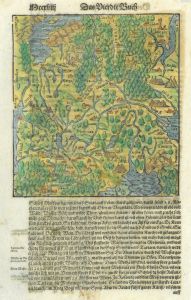 RUSSLAND. - Karte. - Moscowiterlandt. Karte mit Moskau im Mittelpunkt.
Kol. Holzschnitt aus Seb. Münster, "Cosmographia", um 1580, 17 x 16 cm.
Aus einer deutschen Ausgabe, auf der vollen Seite. (Artikelnr. 22746CG)
Erfahren Sie mehr118,00 € Inkl. MwSt. -
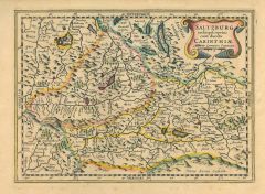 SALZBURG. - Karte. - Saltzburg archiepiscopatus cum ducatu Carinthiae. Grenzkolorierte Karte von Salzburg und Kärnten, mit den angrenzenden Gebieten.
Altkolorierter Kupferstich von Pieter Kaerius, um 1620, 18 x 25 cm. (Artikelnr. 1102GG)
Erfahren Sie mehr200,00 € Inkl. MwSt. -
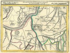 GUASTALLA. - Karte. - Guastalla Sampt dero Gegend Nach P. Coronelli Vorstellung.
Altkol. Kupferstich von Bodenehr, um 1720, 17,5 x 23 cm.
Die grenzkolorierte Karte zeigt Guastalla mit seiner Umgebung. (Artikelnr. 14855BG)
Erfahren Sie mehr130,00 € Inkl. MwSt. -
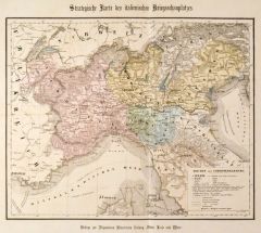 ITALIEN. - Norditalien. - Karte. - Strategische Karte des italienischen Kriegsschauplatzes.
Altkol. Lithographie nach Beckurts, 1859, 30 x 37 cm.
Beilage zu "Über Land und Meer". Zeigt Norditalien im Jahre 1859. (Artikelnr. 14418CG)
Erfahren Sie mehr57,00 € Inkl. MwSt. -
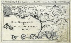 NEAPEL. - Karte. - Die Gegend zwischen Napoli und Gaeta.
Kupferstich von Bodenehr, um 1720, 16 x 26,5 cm.
Die Karte zeigt Neapel mit seiner Umgebung und den Inseln. (Artikelnr. 20991CG)
Erfahren Sie mehr120,00 € Inkl. MwSt. -
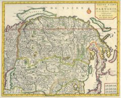 RUSSLAND. - Karte. - Nieuwe Kaart van Tartarie.
Altkol. Kupferstich von Isaak Tirion, um 1730, 28 x 35 cm.
Die grenzkolorierte Karte zeigt Sibirien, Nowaja Semlja, Korea und einen Teil Japans. (Artikelnr. 2706GG)
Erfahren Sie mehr180,00 € Inkl. MwSt. -
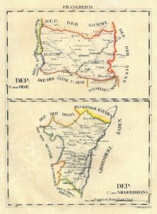 ELSASS. - Karte. - Dep: des Niederrheins, darüber Dep: der Oise". Zwei Karten übereinander.
Grenzkol. Lithographie von Hermann bei Schlieben, 1829, 26 x 19 cm.
Zeigt das Elsass mit Straßburg als Mittelpunkt, die Karte der Oise mit Beauvais, Clermont und Senlis. (Artikelnr. 18722AG)
Erfahren Sie mehr66,00 € Inkl. MwSt. -
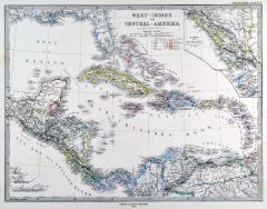
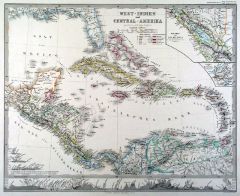 KARIBIK. - Karte. - West-Indien und Central-Amerika. Karibik mit zwei Nebenkarten (Isthmus von Nicaragua und von Panama).
Grenzkol. Kupferstich von Hase und Stichart nach Berghaus aus Stieler bei Perthes, Gotha, 1863, 33 x 41 cm.
Aus: A. Stieler's "Hand-Atlas". - Mit Einzeichnung der europäischen Kolonien und Höhenprofil am unteren Rand. (Artikelnr. 2846AG)
Erfahren Sie mehr95,00 € Inkl. MwSt. -
GRIECHENLAND. - Karte. - Türkei und Griechenland.
Grenzkol. Kupferstich von Herzberg und Brose aus Kiepert bei Reimer, Berlin, 1871, 54 x 43,5 cm.
Espenhorst, PP 20.1.2. - Aus: Heinrich Kiepert's "Neuer Handatlas über alle Theile der Erde" (Ausgabe 1871). - Neue Bearbeitung 1870. - Gesam... (Artikelnr. 19104BG)
Erfahren Sie mehr100,00 € Inkl. MwSt. -
GRIECHENLAND. - Karte. - Türkei und Griechenland.
Grenzkol. Kupferstich von Herzberg und Seitz aus Kiepert bei Reimer, Berlin, 1861, 54 x 43,5 cm.
Espenhorst, PP 20.1.1. - Aus: Heinrich Kiepert's "Neuer Handatlas über alle Theile der Erde" (Ausgabe 1861). - Neue Bearbeitung 1860. - Gesam... (Artikelnr. 19146BG)
Erfahren Sie mehr100,00 € Inkl. MwSt. -
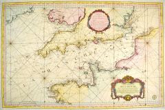 KANAL. - Karte. - Carte Reduite de la Manche Pour servir aux Vaisseaux du Roy.
Altkol. Kupferstich nach S. Bellin, 1763, 57,5 x 89 cm.
Sehr detaillierte Karte des Kanals mit genauer Darstellung der Küsten von England und Frankreich. Die Karte reicht im Norden bis Irland, im Osten bis Ostende. Mit großer altkolorier... (Artikelnr. 20730CG)
Erfahren Sie mehr850,00 € Inkl. MwSt. -
BALKAN. - Karte. - Das Osmanische Europa oder die Eurpaeische Türkey nebst dem Königreiche Griechenland und den Jonischen Inseln. Gebietskarte von Südosteuropa, mit drei Nebenkarten.
Grenzkol. Kupferstich von Ciliax nach Weiland, Weimar im Geograph. Institut, dat. 1840, 57,5 x 47 cm.
Espenhorst, PP 1.1.3. - Die Nebenkarten zeigen: Dardanellen; Bosporus; Umgebungen von Constantinopel. Mit Farberklärungen. Im Rand von a... (Artikelnr. 670FG)
Erfahren Sie mehr128,00 € Inkl. MwSt. -
BALKAN. - Karte. - Das Osmanische Europa oder die Eurpaeische Türkey nebst dem Königreiche Griechenland und den Jonischen Inseln. Gebietskarte von Südosteuropa, mit zwei Nebenkarten.
Grenzkol. Kupferstich nach Weiland/Kiepert, Weimar im Geograph. Institut, dat. 1857, 57,5 x 48 cm.
Espenhorst, PP 1.1.5. - Die Nebenkarten zeigen: Dardanellen; Umgebungen von Constantinopel. Mit Farberklärungen. (Artikelnr. 33163EG)
Erfahren Sie mehr128,00 € Inkl. MwSt. -
 KARIBIK. - Karte. - West-Indien und Central-Amerika. Karibik mit zwei Nebenkarten (Isthmus von Nicaragua und von Panama).
Grenzkol. Kupferstich nach Berghaus aus Stieler bei Perthes, Gotha, 1875, 31 x 40,5 cm.
Espenhorst, PP 2.1.1.1.6. - Aus: A. Stieler's "Hand-Atlas" (6. Ausgabe, Auflage 1875). - Mit Einzeichnung der europäischen Kolonien und 3 Höhenprofil... (Artikelnr. 35411EG)
Erfahren Sie mehr90,00 € Inkl. MwSt. -
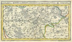 MONS. - Karte. - Mons oder Bergen in Henegau mitt angraenzenden Orthen.
Altkol. Kupferstich von Bodenehr, um 1720, 16,5 x 29,5 cm.
Die grenzkolorierte Karte zeigt Mons mit seiner Umgebung. (Artikelnr. 14843BG)
Erfahren Sie mehr66,00 € Inkl. MwSt. -
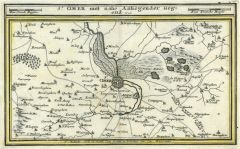 ST. OMER. - Karte. - St. Omer mitt nahe Anliegender Gegend.
Altkol. Kupferstich von Bodenehr, um 1720, 16,5 x 26,5 cm.
Die grenzkolorierte Karte zeigt St. Omer mit seiner Umgebung. (Artikelnr. 14850BG)
Erfahren Sie mehr66,00 € Inkl. MwSt. -
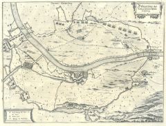
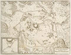 THIONVILLE. - Belagerung der Vestung Diedenhofen. Befestigungsplan und Karte der Umgebung mit der Belagerung von 1643.
Kupferstich von Merian aus "Theatrum Europaeum", 1647, 29 x 37 cm (Fauser 13899). (Artikelnr. 18719CG)
Erfahren Sie mehr76,00 € Inkl. MwSt. -
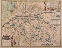 TOURAINE. - Karte. - Touraine. Tvronensis dvcatvs et confinivm Galliae celticae descriptio.
Altkol. Kupferstich von Ortelius, dat. 1562, 35,5 x 45 cm.
Flächenkolorierte Karte des gesamten Gebiets mit zwei altkolorierten Rollwerkkartuschen. (Artikelnr. 12547BG)
Erfahren Sie mehr160,00 € Inkl. MwSt. -
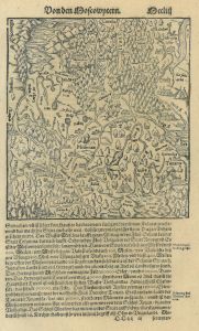 RUSSLAND. - Karte. - Von den Moscowytern. Karte mit Moskau im Mittelpunkt.
Holzschnitt aus Seb. Münster, "Cosmographia", 1588, 17,5 x 16 cm.
Aus der deutschen Ausgabe von 1588. Auf der vollen Buchseite. (Artikelnr. 14635CG)
Erfahren Sie mehr100,00 € Inkl. MwSt. -
BASEL. - Karte. - Strasburg - Basel - Schaffhausen. Karte der Eisenbahnlinie, oben rechts Ansicht des Rheinfalls.
Lithographie, in drei Farben gedruckt, mit 1 Stahlstich, BI, Leipzig, 1873, 20 x 14 cm. (Artikelnr. 12204CG)
Erfahren Sie mehr95,00 € Inkl. MwSt. -
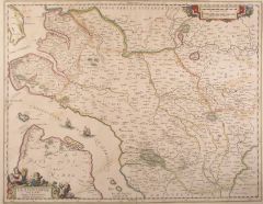
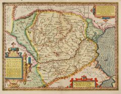 RUMÄNIEN. - Karte. - Daciarum, Moesiarum que, vetus descriptio.
Altkol. Kupferstich von Abraham Ortelius, dat. 1595, 35 x 46 cm.
Die Flächenkolorierte Karte zeigt Rumänien und seine Nachbarländer. - Die Ränder mit Wurmlöchern. (Artikelnr. 1761GG)
Erfahren Sie mehr450,00 € Inkl. MwSt. -
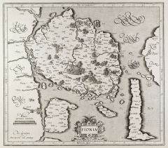 FÜNEN. - Karte. - Fionia.
Kupferstich von G. Mercator, um 1580, 36 x 40 cm.
Frühe Karte der Insel mit Alsen und Langeland. - Rollwerkskartusche unten mittig. - Breitrandig und gut erhalten. (Artikelnr. 25696CG)
Erfahren Sie mehr220,00 € Inkl. MwSt. -
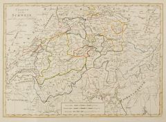 SCHWEIZ. - Karte. - Charte von der Schweiz nach ihrer jezigen Eintheilung.
Kupferstich, Prag, dat. 1809, 29 x 41 cm.
Grenzkolorierte Karte der Schweiz zur Zeit von Napoleon. - Mit geglätteten Faltspuren. (Artikelnr. 2417GG)
Erfahren Sie mehr100,00 € Inkl. MwSt. -
ASIEN. - Karte. - Asien. Gesamtkarte.
Grenzkol. Kupferstich von Jungmann nach Kiepert, Weimar im Geograph. Institut, 1872, 52,5 x 63 cm.
Espenhorst, PP 1.1.6. - Aus: Heinrich Kiepert's "Grosser Hand-Atlas" (43. Ausgabe, Auflage 1872). - Gewann 1871 die einzige Goldmedaille auf... (Artikelnr. 35470EG)
Erfahren Sie mehr130,00 € Inkl. MwSt. -
 SAINTONGE. - Karte - La Saintonge vers le Midy: Auecq Le Brovageais terre d'Arvert &c..
Altkol. Kupferstich von Sanson bei Janssonius, um 1682, 38 x 50 cm.
Grenzkolorierte Karte der Saintonge von der Charente bis Montguyon im Süden, mit altkolorierter figürlicher Kartusche. Breitrandig, der Bug etwas knittrig. (Artikelnr. 12560BG)
Erfahren Sie mehr162,00 € Inkl. MwSt. -
BRENNER. - Karte. - Karte der Brennerbahn zwischen Innsbruck und Bozen.
Lithographie bei Unterberger, um 1867, 91 x 27 cm.
Gefaltet im OPappband. - Mit 6 Blatt "Zur Beachtung" in deutsch, englisch und französisch; die Stationen sind auf der Karte mit rot hervorgehoben. - Sehr gut erhalten. (Artikelnr. 7260CG)
Erfahren Sie mehr142,00 € Inkl. MwSt. -
 GENNEP. - Belägerung des Vesten Schloß u Passes Gennep. Vogelschauansicht mit Karte der Umgebung und Einzeichnung der Truppenstellungen.
Kupferstich von Merian aus "Theatrum Europaeum", 1643, 27 x 35,5 cm (Fauser 4536). (Artikelnr. 18750CG)
Erfahren Sie mehr95,00 € Inkl. MwSt. -
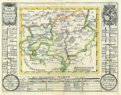 NAMUR. - Karte. - Die Grafschafft Namur Nach dero Eigendlichen Lager.
Altkol. Kupferstich von Bodenehr, um 1720, 15 x 20 cm.
Die grenzkolorierte Karte zeigt die Grafschaft Namur, mit Wappen und Erklärungen. (Artikelnr. 14842BG)
Erfahren Sie mehr62,00 € Inkl. MwSt. -
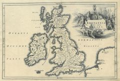 GROSSBRITANNIEN. - Karte. - Britannia medii aevi Romana. Karte des mittelalterlichen Britannien.
Kupferstich von J.G. Beck, 1773, 20,5 x 30,5 cm.
Aus: Christoph Cellarius, "Notitia orbis antiquii sive geographia plenior". - Mit figürlicher Kartusche. (Artikelnr. 19282CG)
Erfahren Sie mehr66,00 € Inkl. MwSt. -
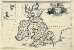 GROSSBRITANNIEN. - Karte. - Insularum Britannicarum facies antiqua. Karte des antiken Britannien.
Kupferstich von J.G. Beck, 1773, 20,5 x 30,5 cm.
Aus: Christoph Cellarius, "Notitia orbis antiquii sive geographia plenior". - Mit figürlicher Kartusche. (Artikelnr. 19308CG)
Erfahren Sie mehr66,00 € Inkl. MwSt. -
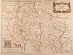 QUERCY. - Karte. - Quercy. Cadvrcivm.
Altkol. Kupferstich von Janssonius, um 1682, 38 x 50 cm.
Grenzkolorierte, nicht genordete Karte des Gebiets um Cahors mit altkolorierter Kartusche und Wappen. Breitrandig, Kolorit teils oxydiert. (Artikelnr. 12556BG)
Erfahren Sie mehr95,00 € Inkl. MwSt. -
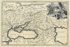 UKRAINE. - Karte. - Sarmatia. Historische Karte der südlichen Ukraine mit dem Kaukasus.
Kupferstich von J.G. Beck, 1773, 20,5 x 30,5 cm.
Aus: Christoph Cellarius, "Notitia orbis antiquii sive geographia plenior". - Mit figürlicher Kartusche. (Artikelnr. 19307CG)
Erfahren Sie mehr75,00 € Inkl. MwSt.