Suchergebnisse für: "europa karte"
-
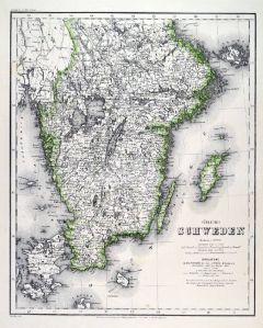 SCHWEDEN. - Karte. - Südliches Schweden.
Grenzkol. Stahlstich aus Meyer bei BI, um 1865, 36,5 x 29,5 cm.
Espenhorst, PP 3.4 (Meyer-Ravenstein 1862-1884). - Aus: Joseph Meyer's "Hand-Atlas", redigiert von Ludwig Ravenstein (1838-1915). - Die Karte zeigt das südliche Schweden bis ... (Artikelnr. 19268BG)
Erfahren Sie mehr120,00 € Inkl. MwSt. -
 SKANDINAVIEN. - Karte. - General Karte von den Königreichen Schweden Daenemark u. Norwegen mit Grönland und den Inseln Island und Faeröer Nro. 67.
Grenzkol. Kupferstich von Reilly, um 1790, 31,5 x 24,5 cm.
Mit drei Nebenkarten von Grönland, Island und den Farör Inseln. (Artikelnr. 10362CG)
Erfahren Sie mehr100,00 € Inkl. MwSt. -
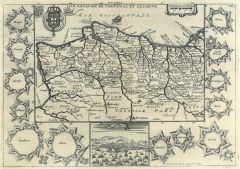
SPANIEN und PORTUGAL. - Karte. - Neueste Karte von Spanien und Portugal. Gesamtkarte, mit zwei Stadtplänen (Madrid, Lissabon).
Grenzkol. Stahlstich aus Meyer bei BI, dat. 1843, 30 x 37 cm.
Espenhorst, PP 3.3. - Aus: "Meyer's Handatlas". - Im Rand leicht fleckig. (Artikelnr. 32953EG)
Erfahren Sie mehr100,00 € Inkl. MwSt. -
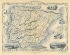 SPANIEN und PORTUGAL. - Karte. - Spain and Portugal.
Grenzkol. Stahlstich von J. Rogers und J. Rapkin, um 1830, 24 x 31 cm.
Gesamtkarte mit drei Ansichten von Lissabon, Madrid und Gibraltar, Stierkampfszene und zwei Wappen. Die Karte in ornamentaler Umrahmung. Mittelburg, sonst tadellos. (Artikelnr. 20076CG)
Erfahren Sie mehr142,00 € Inkl. MwSt. -
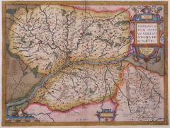
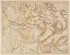
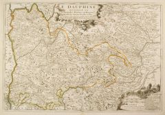 DAUPHINÉ. - Karte. - Le Dauphiné. Distingué en Principales Parties et Regions.
Grenzkol. Kupferstich von Nicolas de Fer, um 1695, 46 x 67 cm.
Die Karte zeigt den Südosten Frankreichs, zwischen der Rhône und der italienischen Grenze, mit Lyon, Grenoble und Turin. (Artikelnr. 2413GG)
Erfahren Sie mehr600,00 € Inkl. MwSt. -
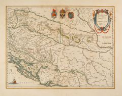
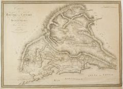 KOTOR. - Karte. - Carte des Bouches de Cattaro et du Montenegro. Karte der Bucht von Kotor mit Montenegro.
Kupferstich von C. Stein nach Max von Traux, dat. 1808, 38 x 53 cm.
Seitlich bis zur Einfassungslinie beschnitten, unten mit hinterlegtem Einriß, knittrig. (Artikelnr. 2404GG)
Erfahren Sie mehr240,00 € Inkl. MwSt. -
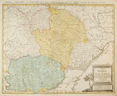 WALACHAI. - Karte. - Charte de la Moldavie & de la Valachie.
Altkol. Kupferstich von Güssefeld bei Homann Erben, dat. 1785, 46 x 57,5 cm.
Die Karte zeigt die Gebiete Transilvanien, Moldavien und die Walachei mit ihren Territorien, mit zahlreichen Orten, Bergen und Flüssen. (Artikelnr. 2409GG)
Erfahren Sie mehr340,00 € Inkl. MwSt. -
 OBERÖSTERREICH. - Karte. - Karte des Gebietes vom Innlauf im Westen bis Krems an der Donau im Osten, von Budweis im Norden bis Mittersill und Knittelfeld im Süden.
Kupferstich von C. Schleich Jun. nach A. Hanser bei C. Reinhard, München, um 1840, 41,5 x 53 cm.
Sehr detaillierte Karte mit dem Donaulauf und Linz im Zentrum. - Breitrandig und gut erhalten. (Artikelnr. 18789CG)
Erfahren Sie mehr142,00 € Inkl. MwSt. -
 ÖSTERREICH. - Karte. - Übersichts Blatt von Österreich u. Preussen. Die Karte zeigt die Gebiete von Österreich und Preussen im Vergleich.
Grenzkol. Stahlstich aus Galletti bei Hartleben, 1840, 20 x 25 cm.
Espenhorst, PP 45.1.1. - Aus: J.G.A. Galletti's "Allgemeine Weltkunde" (9. Ausgabe 1840). - Fünf Karten "neu gestochen von F(ranz) Biller ... wunderschön von Hand kolorie... (Artikelnr. 19288BG)
Erfahren Sie mehr75,00 € Inkl. MwSt. -
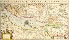 GENFER SEE. - Karte. - Chorographica Tabula Lacus Lemanni.
Altkol. Kupferstich von Jacques Goulart, um 1620, 31 x 54,5 cm.
Dritter Zustand ohne die Porträts am unteren Rand. - Karte des Genfer Sees mit den angrenzenden Gebieten des Herzogtums Savoyen, der Stadt Genf, der Grafschaft Burgund und de... (Artikelnr. 27042CG)
Erfahren Sie mehr900,00 € Inkl. MwSt. -
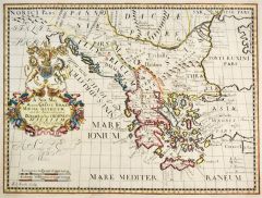 GRIECHENLAND. - Karte. - A New Map of Antient Greece, Thrace, Moesia, Illyricum and the Isles adjoyning Dedicated to his Highness William Duke of Glocester.
Altkol. Kupferstich von Ed. Smith, um 1700, 36 x 48 cm.
Karte des antiken Griechenland. Links kolorierte Kartusche mit Wappen und Meilenzeiger in englischen Meilen. - Seltene Karte. (Artikelnr. 26604CG)
Erfahren Sie mehr400,00 € Inkl. MwSt. -
GRIECHENLAND. - Karte. - Karte von Griechenland.
Holzschnitt aus Seb. Münster, "Cosmographia", um 1580, 16,5 x 13 cm (auf der vollen Buchseite). (Artikelnr. 12356CG)
Erfahren Sie mehr95,00 € Inkl. MwSt. -
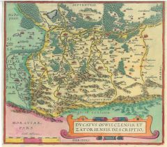 AUSCHWITZ. - Karte. - Ducatus Oswieczensis.
Altkol. Kupferstich von Ortelius, um 1580, 22 x 24,5 cm.
Karte des Herzogtums; mit kleiner Titelkartusche. (Artikelnr. 9478CG)
Erfahren Sie mehr100,00 € Inkl. MwSt. -
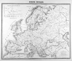 EUROPA. - Gebirge und Gewässer. - Karte. - Europe Physique.
Kupferstich von Delamare nach Testarode bei Lemercier bzw. Furne, Paris, um 1865, 35 x 44 cm.
Aus "Atlas de Géographie Militaire". - Mit Höhenkarte der Wasserscheiden. - Mittig ein paar schwache Fleckchen. (Artikelnr. 34773EG)
Erfahren Sie mehr95,00 € Inkl. MwSt. -
AFRIKA. - Westküste. - Karte. - Senegambien, Sudan und Ober-Guinea. Gebietskarte, mit Nebenkarte der Kapverdischen Inseln.
Grenzkol. Kupferstich nach Weiland, Weimar im Geograph. Institut, dat. 1827, 46,5 x 67,5 cm.
Espenhorst, PP 1.1.2. - Zeigt die westafrikanischen Küstenländer von Kap Blanco (Mauretanien) bis Kap Lopez (Gabun). Mit Farberklärungen für d... (Artikelnr. 33058EG)
Erfahren Sie mehr88,00 € Inkl. MwSt. -
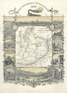 INNSBRUCK. - Eisenbahn. - Neujahrs - Entschuldigungskarte der Stadt Innsbruck für das Jahr 1859. Karte (17,5 x 15,5 cm) der Eisenbahnlinie von Innsbruck nach München. Eröffnet am 24. November 1858. Die Karte umgeben von 12 kleinen Ansi
Lithographie mit Tonplatte bei C. Redlich, Innsbruck, 1859. 36,5 x 25,5 cm.
Mit kleinen, feinen Ansichten von München, Rosenheim, Rattenberg, Hall, Kufstein, Jenbach, Ambras, Innsbruck (Bahnhof, Goldenes Dachl). Mit drei Wappen und einer ... (Artikelnr. 28560CG)
Erfahren Sie mehr1.250,00 € Inkl. MwSt. -
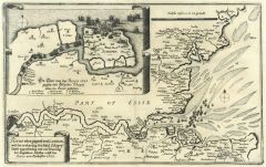 LONDON. - Karte. - Rivier oder gegent von London, mit der eroberung der Insul Schepey, sampt weg nehmung und ver brenung der Englischen Schiffen, auff der Rivier von Rochester. 1667. Karte der Themse von London bis zur Mündung. Oben link
Kupferstich von Merian aus "Theatrum Europaeum", 1677, 22 x 35 cm (vgl. Fauser 11845). (Artikelnr. 18773CG)
Erfahren Sie mehr280,00 € Inkl. MwSt. -
 SPANIEN und PORTUGAL. - Karte. - Form und gestalt Hispanie.
Holzschnitt aus Stumpf, 1606, 12,5 x 15,5 cm (auf der vollen Buchseite).
Karte der Iberischen Halbinsel. (Artikelnr. 4708CG)
Erfahren Sie mehr110,00 € Inkl. MwSt. -
 LA PERCHE. - Karte. - Perchensis Comitatus - La Perche Compte.
Altkol. Kupferstich von Blaeu, um 1620, 37,5 x 49 cm.
Die flächenkolorierte Karte zeigt das Gebiet zwischen Chateaudun, Le Mans, Alenson und Chartres. - Mit altkolorierter Titelkartusche links unten und gouachierter Wappenkartusche rechts... (Artikelnr. 24741CG)
Erfahren Sie mehr250,00 € Inkl. MwSt. -
 LYON. - Karte. - La Sovverainete de Dombes.
Altkol. Kupferstich von W.J. & J. Blaeu, um 1630, 38 x 50 cm.
Grenzkolorierte Karte des nördlichen Gebietes von Lyon bis Pont-de-Vaux im Norden und Bourg-en-Bresse im Osten mit altkolorierter figürlicher Kartusche und Wappen. Breitrandig... (Artikelnr. 12347BG)
Erfahren Sie mehr180,00 € Inkl. MwSt. -
 MEAUX. - Karte. - Valesivm Ducatus. Valois.
Altkol. Kupferstich von W.J. Blaeu, um 1630, 39 x 50 cm.
Grenzkolorierte Karte des Gebietes nord-westlich von Meaux bis Creil im Westen, Compiègne im Norden, Soissons im Osten und la Ferté-sous-Jouarre im Süden, mit altkolorierter figü... (Artikelnr. 12327BG)
Erfahren Sie mehr162,00 € Inkl. MwSt. -
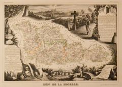 MOSEL. - Karte. - Dépt. de la Moselle. Gesamtkarte des Département.
Grenzkol. Kupferstich bei Laguillermie aus "Atlas universel illustré", um 1860, 28,5 x 41,5 cm; die Karte ca. 18 x 35 cm.
Umgeben von allegorischen Darstellungen, oben eine Gesamtansicht von Metz, sowie rechts und links Legenden. (Artikelnr. 19706BG)
Erfahren Sie mehr120,00 € Inkl. MwSt. -
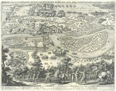 RHEINAU/Elsass. - Wahre Delineation der Schwedischen Schantzen und Schiffbrücken bey Rheinaw, und wie selbige von den Kayserischen eingenohmen worden, 1637. Befestigungsplan mit Karte der Umgebung und der Belagerung, im Hintergrund Ansic
Kupferstich von Merian aus "Theatrum Europaeum", 1639, 26 x 35,5 cm (Fauser 11680). (Artikelnr. 18680CG)
Erfahren Sie mehr133,00 € Inkl. MwSt. -
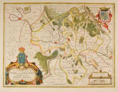 SEDAN. - Karte. - La Sovveraineté de Sedan et de Ravcovrt, et la Prevosté de Doncheri.
Altkol. Kupferstich von Janssosnius aus "Novus Atlas", 1649, 37,5 x 50 cm.
Grenzkolorierte Karte zeigt die Umgebung von Sedan mit altkolorierter Rollwerkkartusche und drei Wappen. Breitrandig und tadellos. (Artikelnr. 1105GG)
Erfahren Sie mehr220,00 € Inkl. MwSt. -
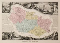 SOMME. - Karte. - Dépt. de la Somme. Gesamtkarte des Département.
Grenzkol. Kupferstich bei Laguillermie aus "Atlas universel illustré", um 1860, 28 x 41,5 cm; die Karte ca. 22 x 31 cm.
Umgeben von allegorischen Darstellungen, rechts oben eine Gesamtansicht von Amiens, sowie rechts und links Legenden. (Artikelnr. 19708BG)
Erfahren Sie mehr120,00 € Inkl. MwSt. -
 TONDER. - Karte. - Praeectvrae Tonderanae ora Maritima.
Altkol. Kupferstich von Christian Rothgiesser bei J. Mejer, um 1660, 39 x 48 cm.
Die grenzkolorierte Karte zeigt das Gebiet südlich von Tonder bis Bargum mit den Inseln um Dageboll. Mit altkolorierter Titelkartusche links oben. - Oben pro... (Artikelnr. 18003BG)
Erfahren Sie mehr380,00 € Inkl. MwSt. -
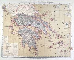 GRIECHENLAND. - Karte. - Griechenland und die Ionischen Inseln.
Farblithographie aus Sohr-Berghaus bei Flemming, Glogau, um 1885, 32,5 x 42 cm.
Espenhorst, PP 4.1.3. - Aus: Sohr-Berghaus's "Hand-Atlas über alle Teile der Erde". - Die Karte zeigt die Präfekturen Mittelgriechenland, Attika, Peloponnes ... (Artikelnr. 19486BG)
Erfahren Sie mehr80,00 € Inkl. MwSt. -
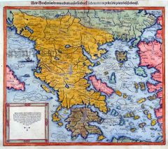 GRIECHENLAND. - Karte. - New Griechenlandt mit andern anstossenden Ländern wie es zu unsern zeiten beschriben ist. Karte von Griechenland und der Westküste Türkei sowie Kreta.
Altkol. Holzschnitt aus Seb. Münster, "Cosmographia", um 1580, 31 x 36 cm.
Mit Kopftitel und Textkartusche links unten. Unten angerändert. Schönes Flächenkolorit. (Artikelnr. 22550CG)
Erfahren Sie mehr450,00 € Inkl. MwSt. -
 KROATIEN. - Karte. - Sclavonia, Croatia, Bosnia cum Dalmatiae parte.
Altkol. Kupferstich von Mercator, um 1650, 35 x 46 cm.
Grenzkolorierte Karte des südlichen Gebiets von Kroatien (mit Inseln Pag, Dugi Otok, Kornat usw.) und Bosnien-Herzegowina mit altkolorierter Titelkartusche rechts oben und drei Wappen... (Artikelnr. 13316BG)
Erfahren Sie mehr350,00 € Inkl. MwSt. -
 ANGERS. - Karte. - Andegavensivm ditionis vera et integra descriptio.
Altkol. Kupferstich von Ortelius, um 1608, 35,5 x 47 cm.
Van den Broecke Nr. 40 mit Abb. - Die flächenkolorierte Karte zeigt das Gebiet um Angers, mit altkolorierter Rollwerkkartusche. - In den breiten Rändern gering fingerfleckig. (Artikelnr. 15642BG)
Erfahren Sie mehr280,00 € Inkl. MwSt. -
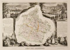 ARDENNES. - Karte. - Dépt. des Ardennes. Gesamtkarte des Département.
Grenzkol. Kupferstich bei Laguillermie aus "Atlas universel illustré", um 1860, 28 x 41 cm; die Karte ca. 22 x 21 cm.
Umgeben von allegorischen Darstellungen, links oben eine Gesamtansicht von Sedan, sowie rechts und links Legenden. (Artikelnr. 19707BG)
Erfahren Sie mehr120,00 € Inkl. MwSt. -
 BEAUVAIS. - Karte. - Comitatvs Bellovacvm, Vernaculè Beavvais.
Altkol. Kupferstich von W.J. & J. Blaeu, um 1630, 38 x 50 cm.
Grenzkolorierte Karte des Gebietes um Limoges, bis Compiègne Osten, Pontoise im Süden und Gisors im Westen. Mit figürlichem Meilenzeiger und Rollwerkkartusche links oben. Bre... (Artikelnr. 12323BG)
Erfahren Sie mehr152,00 € Inkl. MwSt. -
 BRETAGNE. - Karte. - Tabula Ducatus Britanniae Gallis le Gouvernemt General de Bretagne.
Altkol. Kupferstich von Johann Baptist Homann, um 1720, 7,5 x 11 cm.
Flächenkolorierte Karte der gesamten Bretagne mit großer Titelkartusche und Wappen links unten und Grundrissplan von Brest links oben. - Sehr gut erhalten. (Artikelnr. 13318BG)
Erfahren Sie mehr220,00 € Inkl. MwSt. -
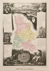 DRÔME. - Karte. - Dépt. de la Drôme. Gesamtkarte des Département.
Grenzkol. Kupferstich bei Laguillermie aus "Atlas universel illustré", um 1860, 42 x 29 cm; die Karte ca. 24 x 16 cm.
Umgeben von allegorischen Darstellungen, oben eine Gesamtansicht von Valence, sowie rechts und links Legenden. (Artikelnr. 19711BG)
Erfahren Sie mehr110,00 € Inkl. MwSt. -
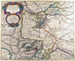
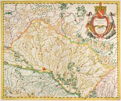 ELSASS. - Karte. - Alsatia inferior.
Altkol. Kupferstich von J. Janssonius nach G. Mercator, um 1630, 37 x 43,5 cm.
Westorientierte Karte mit dem Rheinlauf von Schoenau bis Selz, unten ein Teil von Baden. - Mit altkolorierter figürlicher Kartusche. - Breitrandig und gut erha... (Artikelnr. 27084CG)
Erfahren Sie mehr280,00 € Inkl. MwSt. -
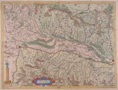 ELSASS. - Karte. - Alsatia superior cu Suntgoia & Brisgoia.
Altkol. Kupferstich von Hondius nach Mercator, 1627, 36 x 47,5 cm.
Die nicht genordete Karte zeigt von links den Rheinlauf ab Basel bis Straßburg auf der rechten Seite; das Elsass oben, der Schwarzwald unten. Mit kleiner Rollwerkskartusch... (Artikelnr. 9804CG)
Erfahren Sie mehr190,00 € Inkl. MwSt. -
FRANKREICH. - Gebirge und Gewässer. - Karte. - Carte Physique de la France. Karte mit den Französischen Wasserscheiden, dazu Gebirgszüge und Flüsse.
Kupferstich von Marlier aus Dussieux bei Lecoffre, dat. 1845, 28 x 39 cm.
Aus: Louis Dussieux's "Atlas Général de Géographie". - Mit Nebenkarte: Mosel- und Rheinmündung. (Artikelnr. 34801EG)
Erfahren Sie mehr65,00 € Inkl. MwSt. -
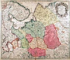 RUSSLAND. - Karte. - Mappae Imperii Moscovitici pars Septentrionalis.
Altkol. Kupferstich von M. Seutter, um 1740, 49,5 x 57 cm.
Die flächenkolorierte Karte zeigt das Gebiet nördlich von Moskau mit dem Ladoga-See, Onega-See, die Halbinsel Kola und dem Weißen Meer. Rechts oben Kartusche. - Die oberen beide... (Artikelnr. 18022BG)
Erfahren Sie mehr320,00 € Inkl. MwSt. -
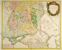 RUSSLAND. - Karte. - Partie Meridionale de la Russie Européene. Die Karte zeigt Teile der Ukraine, Rußlands, Weißrußlands und Georgiens.
Altkol. Kupferstich von R. de Vaugondy, Paris, dat. 1752, 48 x 59 cm.
Im Norden Susdal, im Süden Tiflis, im Osten der Ural (Fluss) und im Westen Minsk. (Artikelnr. 41025EG)
Erfahren Sie mehr280,00 € Inkl. MwSt. -
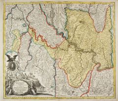
 AARGAU. - Karte. - Argow cum parte merid. Zurichgow.
Altkol. Kupferstich von Mercator, um 1620, 38 x 50 cm.
Die grenzkolorierte Karte zeigt das Gebiet zwischen Thuner-, Zürich- und Walensee, im Mittelpunkt der Vierwaldstätter See. Im Süden bis zum Oberwallis. Mit altkol. Titelkartusche un... (Artikelnr. 3648CG)
Erfahren Sie mehr320,00 € Inkl. MwSt. -
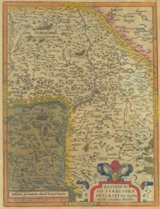 BASEL. - Karte. - Basiliensis Territorii descriptio nova.
Kol. Kupferstich nach Seb. Münster bei Ortelius, um 1580, 32 x 24,5 cm.
Van den Broecke 114a. - Nicht genordete Karte mit Basel im Zentrum. Mit altkolorierter Rollwerkskartusche und Meilenzeiger. - Im Ganzen gering gebräunt und auf feine... (Artikelnr. 27185CG)
Erfahren Sie mehr160,00 € Inkl. MwSt. -
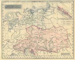
ÖSTERREICH. - Karte. - Ost-Alpenländer.
Grenzkol. Kupferstich von Wirsing aus Kiepert bei Reimer, Berlin, 1858, 44,5 x 55,5 cm.
Espenhorst, PP 20.1.1. - Aus: Heinrich Kiepert's "Neuer Handatlas über alle Theile der Erde" (Ausgabe 1858). - Die Karte zeigt die "K.K. Österreichis... (Artikelnr. 19122BG)
Erfahren Sie mehr100,00 € Inkl. MwSt. -
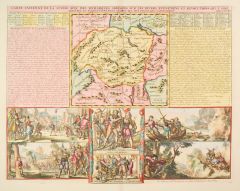 SCHWEIZ. - Karte. - Carte ancienne de la Suisse.
Altkol. Kupferstich bei Chatelain, 1708, 35 x 45 cm.
Historische Karte der Schweiz (19 x 19 cm), seitlich Schrifttafeln zur Geschichte, darunter 6 Szenen aus der Schweizer Geschichte, hauptsächlich Kampfszenen. - Mit breitem Rand und in s... (Artikelnr. 28183CG)
Erfahren Sie mehr380,00 € Inkl. MwSt. -
 SERBIEN. - Karte. - Iustissimae Causae Heroica Virtute propugnatae.
Altkol. Kupferstich von Matthäus Seutter, um 1740, 50 x 57 cm.
Die Karte zeigt das Gebiet von Belgrad sowie das östliche Slowenien. Mit großer figürlichen Titelkartusche unten links, darüber kleines Portrait von Karl VI. - In den Rän... (Artikelnr. 1763GG)
Erfahren Sie mehr500,00 € Inkl. MwSt. -
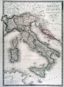 ITALIEN. - Karte. - General Karte von Italien und Dalmatien bis Cattaro, mit Sardinien und Korsika, oben Inschrift, unten Erklärungen.
Grenzkol. Kupferstich von R.v. Rothenburg nach A.H. Brué bei Artaria, Wien, dat. 1824, 50 x 35,5 cm.
Bei den Ortsnamen z.T. Reste von Unterstreichungen mit Bleistift. (Artikelnr. 596FG)
Erfahren Sie mehr140,00 € Inkl. MwSt. -
SCHWEDEN. - Karte. - Dänemark und Süd=Schweden.
Grenzkol. Kupferstich von Sulzer aus Kiepert bei Reimer, Berlin, 1861, 44,5 x 54,5 cm.
Espenhorst, PP 20.1.1. - Aus: Heinrich Kiepert's "Neuer Handatlas über alle Theile der Erde" (Ausgabe 1861). - Die dekorative Karte zeigt gesamt Dänem... (Artikelnr. 19143BG)
Erfahren Sie mehr80,00 € Inkl. MwSt. -
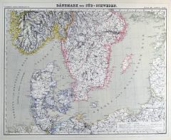 SCHWEDEN. - Karte. - Dänemark und Süd=Schweden.
Grenzkol. Kupferstich von Sulzer aus Kiepert bei Reimer, Berlin, 1858, 44,5 x 54,5 cm.
Espenhorst, PP 20.1.1. - Aus: Heinrich Kiepert's "Neuer Handatlas über alle Theile der Erde" (Ausgabe 1858). - Die dekorative Karte zeigt gesamt Dänem... (Artikelnr. 19028BG)
Erfahren Sie mehr80,00 € Inkl. MwSt. -
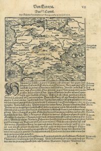
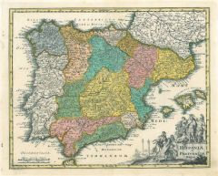 SPANIEN. - Karte. - Hispaniae et Portugaliae Regna.
Altkol. Kupferstich bei Chr. Weigel, 1718, 27,5 x 34 cm.
Aus: Johann David Köhlers "Bequemer Schul= und Reisen=Atlas", 1718. - Karte der iberischen Halbinsel, rechts die balearischen Inseln Ibiza, Mallorca und Menorca. Rechts unten figür... (Artikelnr. 18612BG)
Erfahren Sie mehr240,00 € Inkl. MwSt. -
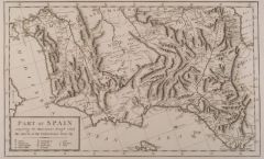 SPANIEN. - Ostspanien. - Karte. - Part of Spain comprising the Provinces trough which the Route of the Pictoresque Tour lay.
Kupferstich, um 1820, 23 x 38 cm.
Nicht genordete Karte vom Osten Spaniens vom Golf von Gibraltar bis Barcelona, im Westen bis Madrid. - Sehr breitrandig. (Artikelnr. 18122CG)
Erfahren Sie mehr114,00 € Inkl. MwSt.