Suchergebnisse für: "europa karte"
-
BÖHMEN und MÄHREN. - Karte. - Böhmen, Mähren, Österreich.
Grenzkol. Kupferstich von Sulzer aus Kiepert bei Reimer, Berlin, 1861, 44,5 x 55,5 cm.
Espenhorst, PP 20.1.2. - Aus: Heinrich Kiepert's "Neuer Handatlas über alle Theile der Erde" (Ausgabe 1861). - Die Karte zeigt das Königreich Böhmen,... (Artikelnr. 19135BG)
Erfahren Sie mehr100,00 € Inkl. MwSt. -
 GALIZIEN. - Karte. - Charte von Ost und West Galizien nach den neuesten astronomischen Ortsbestimmungen entworfen und revidiert auf der Sternwarte Seeberg bey Gotha.
Altkol. Kupferstich nach G.R.v. Schmidburg, Weimar im Geograph. Institut, dat. 1804, 48 x 61 cm.
Die grenzkolorierte Karte sehr detailliert. - Ränder etwas gebräunt. (Artikelnr. 2410GG)
Erfahren Sie mehr340,00 € Inkl. MwSt. -
 ELSASS. - Karte. - Alsatia Landgraviatus cum Suntgoia et Brisgoia.
Kupferstich von Merian aus "Theatrum Europaeum", 1682, 22 x 37 cm.
Westorientierte Karte, oben rechts Titelkartusche. (Artikelnr. 18565CG)
Erfahren Sie mehr114,00 € Inkl. MwSt. -
OBERINNTAL. - Karte. - Karte des Gebietes um den Innlauf in Vorarlberg, Graubünden und Südtirol, im Westen bis zum Silser See, im Osten bis Zirl.
Kupferstich von C. Schleich Jun., um 1830, 25 x 40 cm.
18te Section. - Sehr detaillierte Karte mit Arlberg und Engadin im Zentrum, im Nordwesten der Sentis und Feldkirch, im Nordosten Seefeld, im Südwesten Splügen-Pass und Hinterrhein, i... (Artikelnr. 36275EG)
Erfahren Sie mehr160,00 € Inkl. MwSt. -
 WELTKARTE. - Klimakarte. - Isothermen der Erde. Verbreitung der Vulkane. Darunter: Verbreitung der Baum- und Strauchgewächse und der Kulturgewächse in Europa, auf zwei Karten. Insgesamt vier Darstellungen auf einem Blatt.
Farblithographie nach Kiepert, Weimar im Geograph. Institut, 1886, 49 x 61,5 cm.
Espenhorst, PP 1.1.6. - Aus: Heinrich Kiepert's "Grosser Hand-Atlas" (49. Ausgabe, Auflage 1886). - Kleine, hinterlegte Randeinrisse. (Artikelnr. 35137EG)
Erfahren Sie mehr100,00 € Inkl. MwSt. -
 LIECHTENSTEIN. - Karte. - Karte von Liechtenstein mit dem Rheinlauf von Rorschach bis Sargans.
Altkol. Kupferstich bei Geograph. Institut, Weimar, um 1820, 31 x 41 cm. (Artikelnr. 2479GG)
Erfahren Sie mehr320,00 € Inkl. MwSt. -
BELGIEN. - Karte. - Belgium Regium accuratissime descriptum.
Altkol. Kupferstich von Mich. Kauffer bei Chr. Weigel, 1718, 33 x 38 cm.
Aus: Johann David Köhlers "Bequemer Schul= und Reisen=Atlas", 1718. - Karte von Belgien und Luxemburg, rechts der Rhein von Bonn bis Wesel. Links oben Titelkartusche... (Artikelnr. 246FG)
Erfahren Sie mehr140,00 € Inkl. MwSt. -
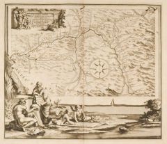
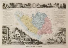 VENDÉE. - Karte. - Dépt. de la Vendée. Gesamtkarte des Département.
Grenzkol. Kupferstich bei Laguillermie aus "Atlas universel illustré", um 1860, 28,5 x 43 cm; die Karte ca. 17 x 24 cm.
Umgeben von allegorischen Darstellungen, unten ein großer Hof mit Bauern beim Getreide dreschen umgeben von verschied... (Artikelnr. 19710BG)
Erfahren Sie mehr120,00 € Inkl. MwSt. -
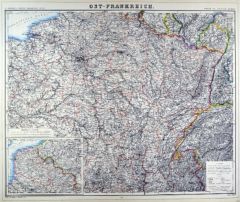
FRANKREICH. - Ostfrankreich. - Karte. - Ost-Frankreich.
Grenzkol. Lithographie von Sulzer und Barth aus Kiepert bei Reimer, Berlin, 1875, 46,5 x 56 cm.
Espenhorst, PP 20.1.2. - Aus: Heinrich Kiepert's "Neuer Handatlas über alle Theile der Erde" (Ausgabe 1875). - Berichtigt 1874. - Die Karte ze... (Artikelnr. 19066BG)
Erfahren Sie mehr70,00 € Inkl. MwSt. -
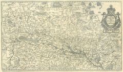
 FRANKREICH. - Ostfrankreich. - Karte. - Ost-Frankreich.
Grenzkol. Lithographie von Sulzer und Barth aus Kiepert bei Reimer, Berlin, 1871, 46,5 x 56 cm.
Espenhorst, PP 20.1.2. - Aus: Heinrich Kiepert's "Neuer Handatlas über alle Theile der Erde" (Ausgabe 1871). - Berichtigt 1870. - Die Karte ze... (Artikelnr. 19097BG)
Erfahren Sie mehr70,00 € Inkl. MwSt. -
INDRE. - Karte. - Département de l'Indre Ci-devant Partie du Berri.
Altkol. Aquatinta, um 1795, 16,5 x 21,5 cm.
Aus der Reihe: "Voyage dans les Departements de la France" von Joseph La Vallée, Marquis de Bois-Robert (1747 - 1816), Paris, 1793-1800. - Die Karte zeigt die Umgebung von Châteauroux". (Artikelnr. 16786BG)
Erfahren Sie mehr48,00 € Inkl. MwSt. -
INDRE-ET-LOIRE. - Karte. - Département d'Indre et Loire Ci-devant la Touraine.
Altkol. Aquatinta, um 1795, 16,5 x 21,5 cm.
Aus der Reihe: "Voyage dans les Departements de la France" von Joseph La Vallée, Marquis de Bois-Robert (1747 - 1816), Paris, 1793-1800. - Die Karte zeigt das Gebiet um Tours. (Artikelnr. 16785BG)
Erfahren Sie mehr48,00 € Inkl. MwSt. -
 ISLE DE FRANCE. - Karte. - Ager Parisiensis vulgo L'Isle de France.
Altkol. Kupferstich von W.J. Blaeu nach Pitheo, um 1630, 38 x 50 cm.
Grenzkolorierte Karte zeigt das Gebiet nördlich von Paris bis Meaux im Osten und Pontoise im Westen, mit altkolorierter, figürlicher Kartusche und Wappen rechts oben. (Artikelnr. 12330BG)
Erfahren Sie mehr220,00 € Inkl. MwSt. -
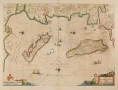 LA ROCHELLE. - Karte. - Insulae divi Martini et Vliarvs, vulgo L'Isle de Ré et Oleron.
Altkol. Kupferstich von Blaeu, um 1610, 39 x 53 cm.
Die grenzkolorierte Karte zeigt La Rochelle mit Umgebung, sowie die davor liegende Ile de Ré und Ile d'Oléron. - Gleichmäßig leicht gebräunt. (Artikelnr. 1768GG)
Erfahren Sie mehr400,00 € Inkl. MwSt. -
LOIRET. - Karte. - Département du Loiret, ci-devant partie de l'Orléanois.
Altkol. Aquatinta, um 1795, 16,5 x 21,5 cm.
Aus der Reihe: "Voyage dans les Departements de la France" von Joseph La Vallée, Marquis de Bois-Robert (1747 - 1816), Paris, 1793-1800. - Die Karte zeigt das Gebiet um Orleans. (Artikelnr. 16789BG)
Erfahren Sie mehr48,00 € Inkl. MwSt. -
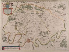
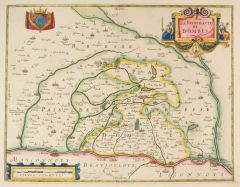 LYON. - Karte. - La Principaute de Dombes. Die nach Osten ausgerichtete Karte zeigt das Gebiet zwischen Mâcon und Lyon an der Saône, der Rhone und dem Fluß Ain.
Altkol. Kupferstich von J.van der Enden bei J. Janssonius, Amsterdam, um 1640, 34,5 x 45 cm.
Koeman, Atlantes Neerlandici, 4820,1A.1. (Artikelnr. 42681EG)
Erfahren Sie mehr240,00 € Inkl. MwSt. -
NIÈVRE. - Karte. - Département de la Nyèvre Ci-devant Nivernois.
Altkol. Aquatinta, um 1795, 16,5 x 21,5 cm.
Aus der Reihe: "Voyage dans les Departements de la France" von Joseph La Vallée, Marquis de Bois-Robert (1747 - 1816), Paris, 1793-1800. - Die Karte zeigt das Gebiet um Nevers. (Artikelnr. 16798BG)
Erfahren Sie mehr48,00 € Inkl. MwSt. -
 ORANGE. - Karte. - La Principavté D'Orange et comtat de Venaissin.
Altkol. Kupferstich von E. Hamersvelt bei P. Schenk & G. Valck, um 1680, 37 x 49 cm.
Flächenkolorierte, nicht genordete Karte zeigt das östliche Gebiet von Pont-St. Esprit bis Avignon mit zwei Kartuschen und Wappen. - Breitrandig und tad... (Artikelnr. 27497CG)
Erfahren Sie mehr170,00 € Inkl. MwSt. -
 PARIS. - Karte. - Carte Partivulire du Terroir et des Environs des Paris qui est la plus grande Partie de l'Isle de France.
Altkol. Kupferstich von N. Visscher, um 1690, 57 x 48,5 cm.
Flächenkolorierte Karte mit der Umgebung von Estampes im Süden bis Chantilly im Norden. Mit Kopftitel. (Artikelnr. 18005BG)
Erfahren Sie mehr280,00 € Inkl. MwSt. -
PUY-DE-DÔME. - Karte. - Département du Puy de Dôme, ci-devant Partie de l'Auvergne.
Altkol. Aquatinta, um 1795, 16,5 x 21,5 cm.
Aus der Reihe: "Voyage dans les Departements de la France" von Joseph La Vallée, Marquis de Bois-Robert (1747 - 1816), Paris, 1793-1800. - Die Karte zeigt die Umgebung von Clermont-Ferrand. (Artikelnr. 16799BG)
Erfahren Sie mehr48,00 € Inkl. MwSt. -
SOMME. - Karte. - Département de la Somme, ci-devant partie de la Picardie.
Altkol. Aquatinta, um 1795, 16,5 x 21,5 cm.
Aus der Reihe: "Voyage dans les Departements de la France" von Joseph La Vallée, Marquis de Bois-Robert (1747 - 1816), Paris, 1793-1800. - Die Karte zeigt das Gebiet um Amiens. (Artikelnr. 16810BG)
Erfahren Sie mehr48,00 € Inkl. MwSt. -
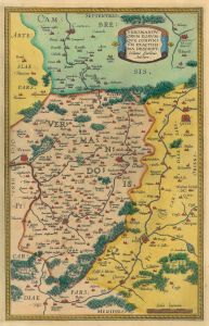 ST. QUENTIN/Dep. Aisne. - Karte. - Veromandvorvm Eorvmqve Confinivm Exactissima Descript. Karte mit dem Gebiet um St. Quentin.
Altkol. Kupferstich von J. Surhon, um 1600, 33 x 21 cm.
Zeigt das Gebiet von Noyon im Süden, bis Cambras im Norden und von Perone im Westen bis Guise im Osten. (Artikelnr. 1091GG)
Erfahren Sie mehr220,00 € Inkl. MwSt. -
GRIECHENLAND. - Karte. - Cronologie historique ... de l'ancienne Grece etc. Karte des antiken Griechenland von Lokris und Böotien bis zum Peloponnes, mit fünf Nebenkarten. Mit ausführlichen Erklärungen unten, links und rechts.
Kupferstich bei Chatelain, 1705, 33 x 44 cm.
Die Nebenkarten zeigen: das antike Athen, Theben und Korinth; Megara; Delos. - Mittelbug. (Artikelnr. 31701EG)
Erfahren Sie mehr150,00 € Inkl. MwSt. -
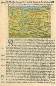
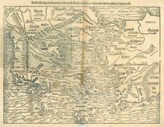 GRIECHENLAND. - Karte. - Neuw Griechenlandt, mit andern anstossenden Ländern, wie es zu unsern zeiten beschriben ist. Karte von Griechenland und der Westküste Türkei sowie Kreta.
Holzschnitt aus Seb. Münster, "Cosmographia", um 1580, 25,5 x 34 cm.
Mit Kopftitel. Im Mittelbug etwas faltig und leicht gebräunt, im Rand unten alt verstärkt, rechts fingerfleckig. (Artikelnr. 35837EG)
Erfahren Sie mehr190,00 € Inkl. MwSt. -
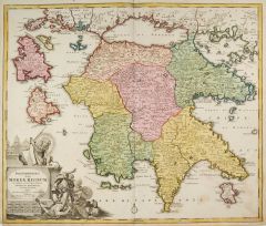 GRIECHENLAND. - Peloponnes. - Karte. - Peloponesus hodie Moreae Regnum.
Altkol. Kupferstich von Johann Baptist Homann, um 1730, 48 x 57 cm.
Die flächenkolorierte Karte zeigt die Peleponnes mit den Inseln Iseln Kefallinia, Sakinthos und Kithira. Mit prächtiger Kartusche unten links. - In den Rändern leicht g... (Artikelnr. 1035BG)
Erfahren Sie mehr350,00 € Inkl. MwSt. -
 BURGUND. - Karte. - Vtrivsqve Bvrgvndiae tum Ducatus tum Comitatus, descriptio.
Altkol. Kupferstich von W.J. Blaeu, um 1630, 38,5 x 49,5 cm.
Die grenzkolorierte Karte zeigt das Gebiet zwischen Langres (Norden), Saint-Hippolyte, Tournus (Süden) und Avallon. Rechts unten altkolorierte figürliche Kartusche mit zwei Wap... (Artikelnr. 18021BG)
Erfahren Sie mehr240,00 € Inkl. MwSt. -
CORRÈZE. - Karte. - Département de la Correze, ci-devant partie du Limosin.
Altkol. Aquatinta, um 1795, 21,5 x 16,5 cm.
Aus der Reihe: "Voyage dans les Departements de la France" von Joseph La Vallée, Marquis de Bois-Robert (1747 - 1816), Paris, 1793-1800. - Die Karte zeigt das Gebiet um Tulle. (Artikelnr. 16778BG)
Erfahren Sie mehr48,00 € Inkl. MwSt. -
DOUBS. - Karte. - Département du Doubs, ci-devant partie de la Franche Comté.
Altkol. Aquatinta, um 1795, 16,5 x 21,5 cm.
Aus der Reihe: "Voyage dans les Departements de la France" von Joseph La Vallée, Marquis de Bois-Robert (1747 - 1816), Paris, 1793-1800. - Die Karte zeigt die Umgebung von Besancon. (Artikelnr. 16780BG)
Erfahren Sie mehr48,00 € Inkl. MwSt. -
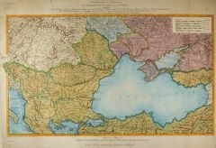 SCHWARZES MEER. - Karte. - Kriegstheater oder Graenzkarte Oesterreichs, Russlands, und der Türkey enthaltend.
Altkol. Kupferstich von F. Müller nach C. Schütz bei Artaria, Wien, dat. 1788, 42 x 72 cm.
Die flächenkolorierte Karte zeigt das Schwarze Meer mit seinen vor allem westlich und nördlich angrenzenden Küstenländern. - Mit Kopftitel. Ge... (Artikelnr. 24847CG)
Erfahren Sie mehr350,00 € Inkl. MwSt. -
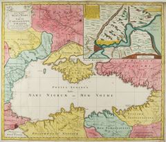 SCHWARZES MEER. - Karte. - Nova Mappa Maris Nigri et Freti Constantino Politani.
Altkol. Kupferstich von Tobias Conrad Lotter, um 1745, 49 x 57,5 cm.
Die flächenkolorierte Karte zeigt das Schwarze Meer mit seinen angrenzenden Küstenländern, im Mittelpunkt die Krim. Rechts oben große Nebenkarte der Verbindung zwisch... (Artikelnr. 24933CG)
Erfahren Sie mehr450,00 € Inkl. MwSt. -
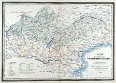
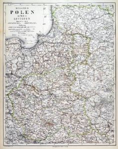 POLEN. - Karte. - Russisch Polen und Theile von Littauen.
Stahlstich mit Farblithographie nach Ravenstein aus Meyer bei BI, um 1865, 43 x 34 cm.
Espenhorst, PP 3.4 (Meyer-Ravenstein 1862-1884). - Aus: Joseph Meyer's "Hand-Atlas", redigiert von Ludwig Ravenstein (1838-1915). -Die Karte zeigt das G... (Artikelnr. 19300BG)
Erfahren Sie mehr140,00 € Inkl. MwSt. -
 SALZBURG. - Karte. - Saltzburg archiepiscopatus cum ducatus Carinthiae.
Altkol. Kupferstich nach Gerhard Mercator bei Hendrik Hondius, dat. 1627, 34 x 47 cm.
Detaillierte Karte des Fürstbistum/Hochstift Salzburg mit kolorierter Titelkartusche rechts oben. Zeigt das Gebiet zwischen Chiemsee und Gmunden im Nord... (Artikelnr. 22687BG)
Erfahren Sie mehr300,00 € Inkl. MwSt. -
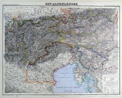 ÖSTERREICH. - Karte. - Ost-Alpenländer.
Grenzkol. Kupferstich von Wirsing aus Kiepert bei Reimer, Berlin, 1861, 44,5 x 55,5 cm.
Espenhorst, PP 20.1.1. - Aus: Heinrich Kiepert's "Neuer Handatlas über alle Theile der Erde" (Ausgabe 1861). - Berichtigt 1860. - Die Karte zeigt die ... (Artikelnr. 19133BG)
Erfahren Sie mehr100,00 € Inkl. MwSt. -
ÖSTERREICH. - Karte. - Ost-Alpenländer.
Grenzkol. Kupferstich von Wirsing aus Kiepert bei Reimer, Berlin, 1875, 44,5 x 55,5 cm.
Espenhorst, PP 20.1.2. - Aus: Heinrich Kiepert's "Neuer Handatlas über alle Theile der Erde" (Ausgabe 1875). - Berichtigt 1874. - Die Karte zeigt die ... (Artikelnr. 19069BG)
Erfahren Sie mehr100,00 € Inkl. MwSt. -
ÖSTERREICH. - Karte. - Ost-Alpenländer.
Grenzkol. Kupferstich von Wirsing aus Kiepert bei Reimer, Berlin, 1871, 44,5 x 55,5 cm.
Espenhorst, PP 20.1.2. - Aus: Heinrich Kiepert's "Neuer Handatlas über alle Theile der Erde" (Ausgabe 1871). - Berichtigt 1870. - Die Karte zeigt die ... (Artikelnr. 19091BG)
Erfahren Sie mehr100,00 € Inkl. MwSt. -
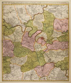
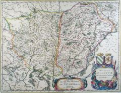
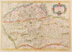
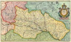
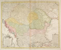 SÜDOSTEUROPA. - Karte. - Carte d'Hongrie en general, contenant selon la Divison ancienne & methodique.
Altkol. Kupferstich von Homann Erben, um 1730, 47 x 59 cm.
Die flächenkolorierte Karte zeigt das Königreich Ungarn mit Kroatien, Dalmatien, Bosnien, Serbien, Transsylvanien, Walachei und Moldau. Mit figürlicher Kartusche und Erklärung.... (Artikelnr. 1436GG)
Erfahren Sie mehr250,00 € Inkl. MwSt. -
 DÄNEMARK. - Karte. - Regni Danicae Insulae Seelandia, Fionia, Langelandia, Lalandia, Falstria, Langelandia Mona.
Altkol. Kupferstich von M. Seutter, um 1740, 50 x 57,5 cm.
Flächenkolorierte Karte der dänischen Ostseeinseln. Zeigt u.a. die Inseln Fünen, Langeland, Aero, Seeland, Falster, Lolland und Mon. Rechts unten große figürliche Kartusche mi... (Artikelnr. 27804CG)
Erfahren Sie mehr320,00 € Inkl. MwSt. -
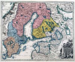 SCHWEDEN. - Karte. - Regnum Sueviae Cum Ducatu Finniae, Lapponia, Livonia, Nordlandia, Ingria.
Altkol. Kupferstich bei Chr. Weigel, 1718, 31 x 38,5 cm.
Aus: Johann David Köhlers "Bequemer Schul= und Reisen=Atlas", 1718. - Die Karte zeigt das gesamte Schweden, Finnland und Estland, mit Bottnischen und Finnischen Meerbusen. Rechts un... (Artikelnr. 18654BG)
Erfahren Sie mehr220,00 € Inkl. MwSt. -
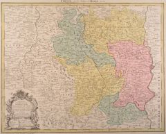
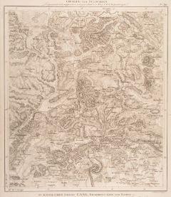
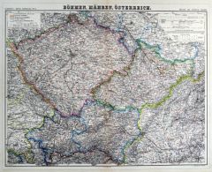 BÖHMEN und MÄHREN. - Karte. - Böhmen, Mähren, Österreich.
Grenzkol. Kupferstich von Sulzer aus Kiepert bei Reimer, Berlin, 1871, 44,5 x 55,5 cm.
Espenhorst, PP 20.1.2. - Aus: Heinrich Kiepert's "Neuer Handatlas über alle Theile der Erde" (Ausgabe 1871). - Berichtigt 1869. - Die Karte zeigt das K... (Artikelnr. 19090BG)
Erfahren Sie mehr100,00 € Inkl. MwSt. -
BÖHMEN und MÄHREN. - Karte. - Böhmen, Mähren, Österreich.
Grenzkol. Kupferstich von Sulzer aus Kiepert bei Reimer, Berlin, 1875, 44,5 x 55,5 cm.
Espenhorst, PP 20.1.2. - Aus: Heinrich Kiepert's "Neuer Handatlas über alle Theile der Erde" (Ausgabe 1875). - Berichtigt 1874. - Die Karte zeigt das K... (Artikelnr. 19071BG)
Erfahren Sie mehr100,00 € Inkl. MwSt. -
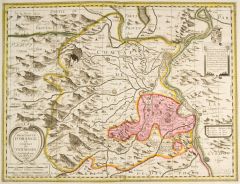
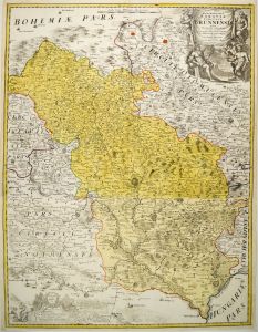 MÄHREN. - Karte. - Marchionatus Moraviae Circulus Brunnensis quem Mandato Caesareo accuratè emensus.
Altkol. Kupferstich von Johann Baptist Homann, um 1720, 78 x 60 cm.
Die zweiteilige, flächenkolorierte Karte zeigt das Gebiet um Brünn und zwischen Zwittau (Norden), Wischau, Ravensburg (Süden) und Trebitsch. - Untere Kartusche etwas fl... (Artikelnr. 27331CG)
Erfahren Sie mehr250,00 € Inkl. MwSt. -
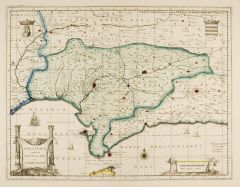 ANDALUSIEN. - Karte. - Andaluzia continens Sevillam et Cordvbam.
Altkol. Kupferstich von Petrus Schenk bei Gerard Valck, um 1700, 37,5 x 49 cm.
Die teilkolorierte Karte zeigt Andalusien mit den Städten Sevilla, Cordoba, Gibraltar, Granada und Malaga. - Kartusche links unten, 2 Wappen, Meilenzeiger, Win... (Artikelnr. 2674GG)
Erfahren Sie mehr320,00 € Inkl. MwSt. -
 TIVOLI. - Karte. - Genordete Landkarte des Gebietes zwischen Tivoli im Westen und Subiaco im Osten mit dem Lauf des Aniene.
Kupferstich von Jan van Vianen nach Jan Goree bei Francois Halma, 1704, 34 x 39 cm.
Die Karte zeigt das Gebiet in der Antike. - Links oben Titelkartusche, unten große Uferlandschaft mit dem Flußgott des Anio und eine weibliche Figur mit ... (Artikelnr. 28482CG)
Erfahren Sie mehr280,00 € Inkl. MwSt. -
 ITALIEN. - Norditalien. - Karte. - Karte des Königreiches Lombardie-Venedig, mit Südtirol vom Gardasee bis Gossensass, unten Inschrift, Erklärungen und Kreiseinteilung.
Mehrfarbendruck in Typometrie von F. Raffelsberger bei J. Bermann, Wien, dat. 1841, 34 x 49 cm.
Aus "Austria. Erster Typometrischer Atlas für Geschäftsleute jeder Art, Gymnasien, Schulen und Zeitungsleser", Wien, 1841 bzw, 1843. - Karte ... (Artikelnr. 577FG)
Erfahren Sie mehr180,00 € Inkl. MwSt. -
 ELSASS. - Karte. - Alsatia Landgraviatus Suntgoia et Brisgoia.
Kol. Kupferstich aus Gottfried, "Archontologia", 1649, 22 x 37 cm.
Westorientierte Karte, oben rechts Titelkartusche. Sehr schönes Flächenkolorit. (Artikelnr. 13864CG)
Erfahren Sie mehr124,00 € Inkl. MwSt. -
 POLEN. - Karte. - Von dem künigreich Poland.
Kol. Holzschnitt aus Seb. Münster, "Cosmographia", um 1590, 12 x 15,5 cm.
Nicht genordete Karte. - Auf der ganzen Buchseite. (Artikelnr. 22738CG)
Erfahren Sie mehr140,00 € Inkl. MwSt. -
 SCHAFFHAUSEN. - Karte. - Karte des Gebietes um Schaffhausen mit Diessenhofen, im Norden bis Fürstenberg.
Kupferstich von Abel nach Ammann bei Cotta, um 1800, 43 x 37 cm. (Artikelnr. 12317CG)
Erfahren Sie mehr133,00 € Inkl. MwSt. -
AIN. - Karte. - Département de l'Ain, ci-devant la Bresse, le Bugey et Dombes.
Altkol. Aquatinta, um 1795, 16,5 x 21,5 cm.
Aus der Reihe: "Voyage dans les Departements de la France" von Joseph La Vallée, Marquis de Bois-Robert (1747 - 1816), Paris, 1793-1800. - Die Karte zeigt das Gebiet um Bourg-en-Bresse. (Artikelnr. 16815BG)
Erfahren Sie mehr48,00 € Inkl. MwSt. -
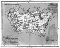 VOSGES. - Karte. - Département des Vosges, ci-devant partie de la Lorraine et du Barrois.
Altkol. Aquatinta, um 1795, 16,5 x 21,5 cm.
Aus der Reihe: "Voyage dans les Departements de la France" von Joseph La Vallée, Marquis de Bois-Robert (1747 - 1816), Paris, 1793-1800. - Die Karte zeigt das Gebiet um Épinal. (Artikelnr. 16813BG)
Erfahren Sie mehr48,00 € Inkl. MwSt.